
TIMOR SEA : TROPICAL CYCLONE LAURENCE (06S)
Moderator: S2k Moderators
Re: TIMOR SEA : SEVERE TROPICAL CYCLONE LAURENCE (06S)
Real bomber. This is a killer cyclone.
0 likes


-
Crostorm

- Category 5

- Posts: 2060
- Age: 51
- Joined: Mon Dec 25, 2006 3:51 pm
- Location: Croatia-Europe
- Contact:
Re: TIMOR SEA : SEVERE TROPICAL CYCLONE LAURENCE (06S)
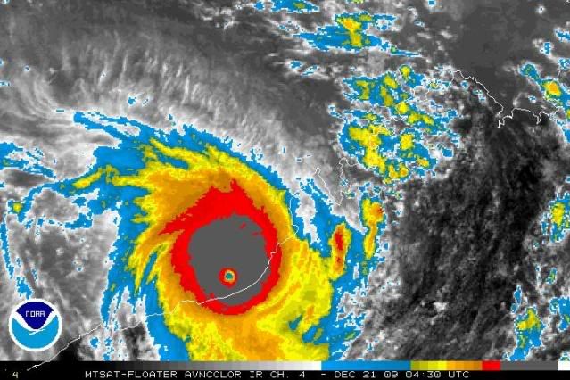
Current Intensity Analysis
UW - CIMSS
ADVANCED DVORAK TECHNIQUE
ADT-Version 8.1.1
Tropical Cyclone Intensity Algorithm
----- Current Analysis -----
Date : 21 DEC 2009 Time : 053000 UTC
Lat : 19:25:00 S Lon : 120:38:10 E
CI# /Pressure/ Vmax
7.0 / 899.5mb/140.0kt
Final T# Adj T# Raw T#
7.0 6.9 7.2
Latitude bias adjustment to MSLP : +1.5mb
Estimated radius of max. wind based on IR : 14 km
Center Temp : -12.9C Cloud Region Temp : -81.1C
Scene Type : EYE
Positioning Method : RING/SPIRAL COMBINATION
Ocean Basin : INDIAN
Dvorak CI > MSLP Conversion Used : PACIFIC
Tno/CI Rules : Constraint Limits : 2.7T/12hr
Weakening Flag : OFF
Rapid Dissipation Flag : OFF
0 likes

-
Crostorm
- Category 5
- Posts: 2060
- Age: 51
- Joined: Mon Dec 25, 2006 3:51 pm
- Location: Croatia-Europe
- Contact:
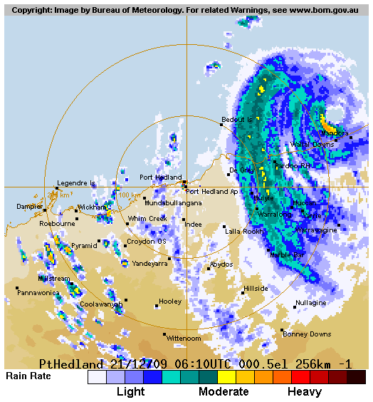
Latest Coastal Weather Observations for Mandora
http://www.bom.gov.au/products/IDW60701 ... 4200.shtml
http://www.bom.gov.au/products/IDW60701 ... 4200.shtml
0 likes


-
Blowme
- Tropical Wave

- Posts: 3
- Age: 52
- Joined: Sun Dec 20, 2009 6:05 pm
- Location: Tom Price Western Australia
Re: TIMOR SEA : SEVERE TROPICAL CYCLONE LAURENCE (06S)
Summary Details at:
1100 WST Mon 21 Dec 2009
Cyclone Name Laurence
Severity Category 5
Max Winds 204 gusting to 287 km/h
Central Pressure 929 hPa
Recent Movement S 6 km/h
Location 19.1S 120.5E
Confidence Accurate within 19 km
Radius to Gales 130 km
1100 WST Mon 21 Dec 2009
Cyclone Name Laurence
Severity Category 5
Max Winds 204 gusting to 287 km/h
Central Pressure 929 hPa
Recent Movement S 6 km/h
Location 19.1S 120.5E
Confidence Accurate within 19 km
Radius to Gales 130 km
0 likes
I know you guys love wind but I don't
-
HURAKAN

- Professional-Met

- Posts: 46084
- Age: 39
- Joined: Thu May 20, 2004 4:34 pm
- Location: Key West, FL
- Contact:
Re: TIMOR SEA : SEVERE TROPICAL CYCLONE LAURENCE (06S)
TROPICAL CYCLONE ADVICE NUMBER 81
Issued at 2:50 pm WST on Monday, 21 December 2009
BY THE BUREAU OF METEOROLOGY
TROPICAL CYCLONE WARNING CENTRE PERTH
A Cyclone WARNING continues for coastal areas from Bidyadanga to Port Hedland
and adjacent inland parts including Marble Bar, Nullagine and Telfer.
A Cyclone WATCH continues for inland parts of the southwest Kimberley and
eastern Pilbara, extending a long way inland to the WA border and including
Warburton and Giles.
At 2:00 pm WST Severe Tropical Cyclone Laurence was estimated to be
35 kilometres north of Wallal and
230 kilometres east northeast of Port Hedland
moving south southeast at 9 kilometres per hour.
Severe Tropical Cyclone Laurence will cross the coast near Wallal during this
afternoon and evening. VERY DESTRUCTIVE winds with gusts to 285 kilometres per
hour will occur on the Pilbara-Kimberley coast this afternoon, and will extend
inland close to the system centre during the evening. People in the area are
specifically warned of the DANGEROUS STORM TIDE expected as the cyclone centre
approaches the coast. Tides are likely to rise significantly above the normal
high tide mark with DAMAGING WAVES and DANGEROUS FLOODING.
DESTRUCTIVE winds are expected to extend inland overnight and during Tuesday,
possibly reaching as far inland as Telfer. GALES are occurring along the coast
between Bidyadanga and Wallal and will extend well inland during Tuesday and
Wednesday, reaching the vicinity of Giles and Warburton by Wednesday evening.
Heavy rainfall is falling between De Grey and Mandora and extends inland. Heavy
rainfall is expected to extend into the inland eastern Pilbara on Tuesday.
FESA-State Emergency Service advises as a precautionary measure the following
community alerts:
RED ALERT: People in or near communities from Sandfire to Pardoo and inland to
Yarrie need to go to shelter immediately.
YELLOW ALERT: People in or near Marble Bar and Nullagine need to take action and
get ready to shelter from a cyclone.
BLUE ALERT: People in or near communities from De Grey to Port Hedland and
inland to Marble Bar, Nullagine and Telfer need to prepare for cyclonic weather.
ALL CLEAR: People in or near Bidyadanga are advised that the wind dangers have
passed and you should proceed with caution
Communities in the southwest Kimberley and eastern Pilbara should listen for the
next advice.
Details of Severe Tropical Cyclone Laurence at 2:00 pm WST:
.Centre located near...... 19.5 degrees South 120.6 degrees East
.Location accuracy........ within 20 kilometres
.Recent movement.......... towards the south southeast at 9 kilometres per hour
.Wind gusts near centre... 285 kilometres per hour
.Severity category........ 5
.Central pressure......... 929 hectoPascals
The next advice will be issued by 6:00 pm WST Monday 21 December.Cyclone advices
and State Emergency Service Community Alerts are available by
dialling 1300 659 210
A map showing the track of the cyclone is available at:
http://www.bom.gov.au/weather/cyclone
0 likes
-
Blowme
- Tropical Wave
- Posts: 3
- Age: 52
- Joined: Sun Dec 20, 2009 6:05 pm
- Location: Tom Price Western Australia
Re: TIMOR SEA : SEVERE TROPICAL CYCLONE LAURENCE (06S)
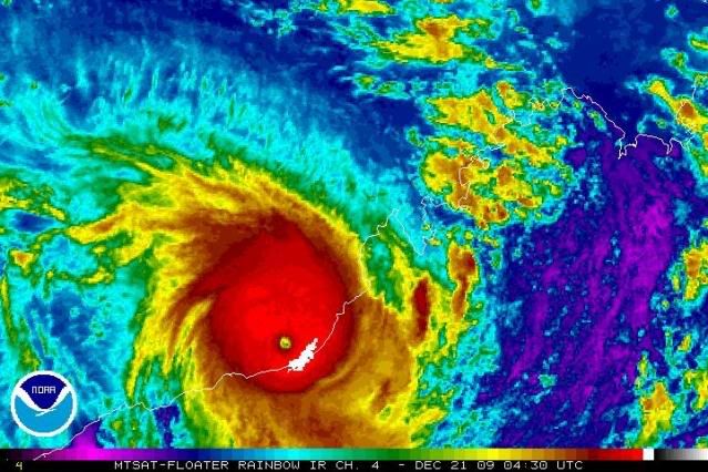
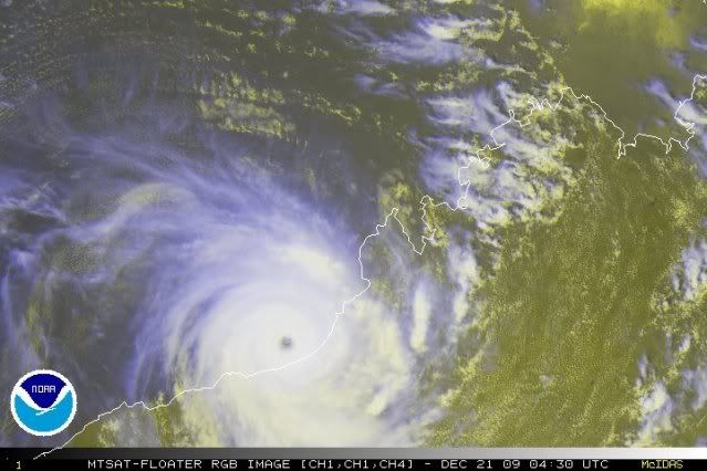
Severe Tropical Cyclone Laurence has intensified further and has been upgraded to category 5. The cyclone has a well defined centre on the Broome and Port Hedland radar and an eye is clearly visible on infrared satellite imagery.
Consensus forecasts indicate a coastal crossing east of Port Hedland in the vicinity of Wallal or Sandfire Roadhouse tonight at category 5 intensity. In the longer term the system is expected to take on a more SEly motion and accelerate significantly. Even though weakening may occur significant wind and rain impacts should be expected at inland locations.
Heavy rainfall is expected along the track path as the system heads inland, with falls in excess of 400mm near the coast and 200mm inalnd likely.
0 likes
I know you guys love wind but I don't
-
Crostorm
- Category 5
- Posts: 2060
- Age: 51
- Joined: Mon Dec 25, 2006 3:51 pm
- Location: Croatia-Europe
- Contact:
Re: TIMOR SEA : SEVERE TROPICAL CYCLONE LAURENCE (06S)
Mandora is reporting 965hPa,wind gust 152km/h
http://www.weatherzone.com.au/station.j ... st=ob&ut=1
http://www.weatherzone.com.au/station.j ... st=ob&ut=1
0 likes
-
brunota2003

- S2K Supporter

- Posts: 9476
- Age: 35
- Joined: Sat Jul 30, 2005 9:56 pm
- Location: Stanton, KY...formerly Havelock, NC
- Contact:
-
P.K.

- Professional-Met
- Posts: 5149
- Joined: Thu Sep 23, 2004 5:57 pm
- Location: Watford, England
- Contact:
Re: TIMOR SEA : SEVERE TROPICAL CYCLONE LAURENCE (06S)
Landfall as a cat 5.
WTAU05 APRF 211305
IDW23100
40:3:2:24:20S121E999:11:00
PAN PAN
HIGH SEAS WEATHER WARNING FOR METAREA 10 ISSUED BY THE
AUSTRALIAN BUREAU OF METEOROLOGY TROPICAL CYCLONE WARNING CENTRE PERTH
AT 1302UTC 21 DECEMBER 2009
HURRICANE FORCE WIND WARNING
Please be aware, wind gusts can be a further 40 percent stronger than the
averages given here, and maximum waves may be up to twice the height.
SITUATION
At 1200 UTC Severe Tropical Cyclone Laurence was centred over land within 10
nautical miles of
latitude twenty decimal zero south (20.0S)
longitude one hundred and twenty decimal eight east (120.8E)
Recent movement : south southeast at 6 knots
Maximum winds : 110 knots
Central pressure: 927 hPa
AREA AFFECTED
Within 80 nautical miles of the centre.
FORECAST
Maximum winds to 110 knots near the centre easing to 75 knots by 0000 UTC 22
December over land.
Winds above 64 knots within 15 nautical miles of centre with very high to
phenomenal seas.
Winds above 48 knots within 25 nautical miles of centre with very rough to high
seas and moderate to heavy swell.
Winds above 34 knots within 70 nautical miles of centre with rough to very
rough seas and moderate swell.
Forecast positions
At 0000 UTC 22 December: Over land within 35 nautical miles of 21.0 south 121.3
east
Central pressure 960 hPa.
Winds to 75 knots.
At 1200 UTC 22 December: Over land within 65 nautical miles of 22.4 south 122.4
east
Central pressure 981 hPa.
Winds to 50 knots.
REMARKS
All ships in the area please send weather reports every three hours.
Regular weather observing ships use normal channels.
Other ships please use either email to tcwcwa@bom.gov.au or fax to +61892632261
or satellite to SAC 1241 through Land Earth Station Perth 312.
Next warning will be issued by 1900 UTC 21 December 2009.
WEATHER PERTH
0 likes
-
CrazyC83
- Professional-Met
- Posts: 34315
- Joined: Tue Mar 07, 2006 11:57 pm
- Location: Deep South, for the first time!
Mandora's lowest pressure was 928mb with winds of about 75 kt at the time - at landfall, the pressure was likely 920mb.
As for the winds at landfall, I would guess 140 kt.
As for the winds at landfall, I would guess 140 kt.
Last edited by CrazyC83 on Mon Dec 21, 2009 8:47 am, edited 1 time in total.
0 likes

Re: TIMOR SEA : SEVERE TROPICAL CYCLONE LAURENCE (06S)
JTWC says on the last warning that it may have peaked at 130 kt, I would say 140 kt.
0 likes
-
cycloneye

- Admin

- Posts: 149275
- Age: 69
- Joined: Thu Oct 10, 2002 10:54 am
- Location: San Juan, Puerto Rico
Re: TIMOR SEA : SEVERE TROPICAL CYCLONE LAURENCE (06S)
WTXS33 PGTW 211500
MSGID/GENADMIN/NAVMARFCSTCEN PEARL HARBOR HI/JTWC//
SUBJ/TROPICAL CYCLONE 06S (LAURENCE) WARNING NR 015//
RMKS/
1. TROPICAL CYCLONE 06S (LAURENCE) WARNING NR 015
02 ACTIVE TROPICAL CYCLONES IN SOUTHIO
MAX SUSTAINED WINDS BASED ON ONE-MINUTE AVERAGE
WIND RADII VALID OVER OPEN WATER ONLY
---
WARNING POSITION:
211200Z --- NEAR 20.0S 120.8E
MOVEMENT PAST SIX HOURS - 170 DEGREES AT 05 KTS
POSITION ACCURATE TO WITHIN 020 NM
POSITION BASED ON EYE FIXED BY SATELLITE
PRESENT WIND DISTRIBUTION:
MAX SUSTAINED WINDS - 070 KT, GUSTS 085 KT
WIND RADII VALID OVER OPEN WATER ONLY
DISSIPATING AS A SIGNIFICANT TROPICAL CYCLONE OVER LAND
REPEAT POSIT: 20.0S 120.8E
---
FORECASTS:
12 HRS, VALID AT:
220000Z --- 21.1S 121.2E
MAX SUSTAINED WINDS - 030 KT, GUSTS 040 KT
WIND RADII VALID OVER OPEN WATER ONLY
DISSIPATED AS A SIGNIFICANT TROPICAL CYCLONE OVER LAND
---
REMARKS:
211500Z POSITION NEAR 20.3S 120.9E.
TROPICAL CYCLONE (TC) 06S (LAURENCE), LOCATED APPROXIMATELY 130 NM
EAST OF PORT HEDLAND, AUSTRALIA, HAS TRACKED SOUTHWARD AT 05 KNOTS
OVER THE PAST SIX HOURS. RECENT PORT HEDLAND RADAR IMAGERY SHOWS THE
LOW LEVEL CIRCULATION CENTER HAS BEEN OVER LAND FOR ALMOST 4 HOURS,
AND IS CURRENTLY LOCATED APPROXIMATELY 20 NAUTICAL MILES SOUTH OF
MANDORA. CURRENT OBSERVATIONS FROM MANDORA INDICATE THAT THE SYSTEM
HAS WEAKENED TO 70 KNOTS FROM A PEAK INTENSITY OF OVER 130 KNOTS
JUST PRIOR TO LANDFALL AT 0830Z. THE SYSTEM WILL RAPIDLY DECAY OVER
LAND WHILE TRACKING DEEPER INTO INTERIOR WESTERN AUSTRALIA. THIS IS
THE FINAL WARNING ON THIS SYSTEM BY THE JOINT TYPHOON WARNING CENTER
(NAVMARFCSTCEN). THE SYSTEM WILL BE CLOSELY MONITORED FOR SIGNS OF
REGENERATION. REFER TO TROPICAL CYCLONE 05S (FIVE) WARNINGS (WTXS32
PGTW) FOR TWELVE-HOURLY UPDATES.//
NNNN
0 likes
Visit the Caribbean-Central America Weather Thread where you can find at first post web cams,radars
and observations from Caribbean basin members Click Here
and observations from Caribbean basin members Click Here
Who is online
Users browsing this forum: No registered users and 33 guests