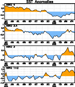
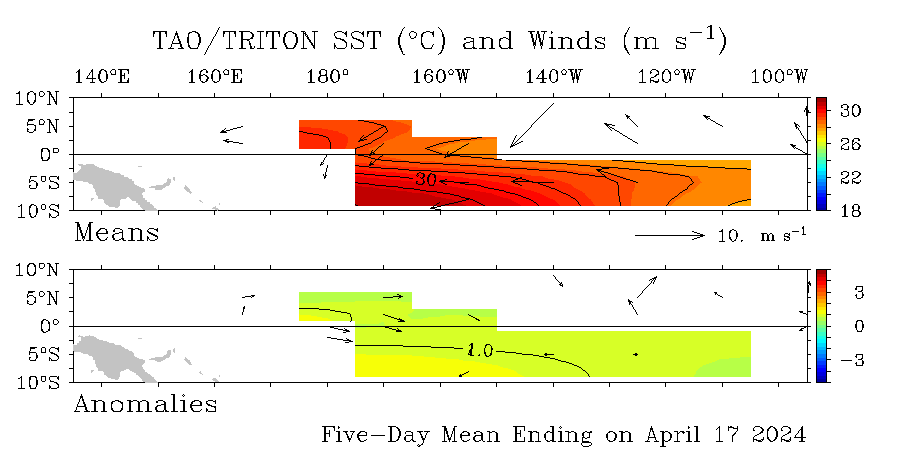
ENSO Updates (2007 thru 2023)

This is the general tropical discussion area. Anyone can take their shot at predicting a storms path.

Moderator: S2k Moderators

Forum rules

The posts in this forum are NOT official forecasts and should not be used as such. They are just the opinion of the poster and may or may not be backed by sound meteorological data. They are NOT endorsed by any professional institution or STORM2K. For official information, please refer to products from the National Hurricane Center and National Weather Service.

Help Support Storm2K
Message
Author
User avatar
cycloneye
Admin
Admin
Posts: 145299
Age: 68
Joined: Thu Oct 10, 2002 10:54 am
Location: San Juan, Puerto Rico

Re: ENSO Updates=Moderate El Nino thru early 2010

#1021 Postby cycloneye » Mon Dec 07, 2009 4:28 pm

cycloneye wrote:Its early but these are the most important and reliable ENSO models,CFS and POAMA models and both show the trend towards neutral ENSO starting by late spring or early summer.Lets continue to follow the data to see if the proyections are good about El Nino fading by late spring 2010.

Australian model POAMA

Image

NCEP model CFS

Image


I think we will have to wait to around March to see how things stand at that point about if El Nino starts to diminuish or it hangs a little longer at moderate status.I am partly with Derek in terms of still having El Nino when June 1 2010 arrives,but I differ that it will be like it is at this time,moderate.Lets wait and see the trends to see if El Nino starts to fade faster,slower or mantains to then start to make our projections about what to expect in the 2010 Atlantic Hurricane Season.
0 likes   
Visit the Caribbean-Central America Weather Thread where you can find at first post web cams,radars
and observations from Caribbean basin members Click Here

User avatar
Blown Away
S2K Supporter
S2K Supporter
Posts: 10145
Joined: Wed May 26, 2004 6:17 am

Re: ENSO Updates=Moderate El Nino thru early 2010

#1022 Postby Blown Away » Mon Dec 07, 2009 7:39 pm

Odds are there will be Neutral conditions during the heart of the 2010 season.
0 likes   
Hurricane Eye Experience: David 79, Irene 99, Frances 04, Jeanne 04, Wilma 05... EYE COMING MY WAY IN 2024…
Hurricane Brush Experience: Andrew 92, Erin 95, Floyd 99, Matthew 16, Irma 17, Ian 22, Nicole 22…

User avatar
cycloneye
Admin
Admin
Posts: 145299
Age: 68
Joined: Thu Oct 10, 2002 10:54 am
Location: San Juan, Puerto Rico

Re: ENSO Updates=Moderate El Nino thru early 2010

#1023 Postby cycloneye » Thu Dec 10, 2009 9:09 am

Climate Prediction Center December update=El Nino to last thru the spring

The question is how will be the status of El Nino by late spring,moderate,weak or gone?

http://www.cpc.ncep.noaa.gov/products/a ... odisc.html

Synopsis: El Niño is expected to continue and last at least into the Northern Hemisphere spring 2010.

El Niño strengthened from October to November 2009, as sea surface temperature (SST) anomalies increased across the central and eastern equatorial Pacific Ocean (Fig. 1 and Fig. 2). The Niño-3.4 index value remained steady during November with the most recent weekly value at +1.7oC (Fig. 2). Consistent with this warmth, upper-ocean heat content anomalies remained positive (Fig. 3) and subsurface temperature anomalies shifted eastward across the eastern Pacific, with the largest departures exceeding +4oC by the end of the month (Fig. 4). Also, the low-level and upper-level wind anomalies over the equatorial Pacific were highly variable during the month due to the Madden-Julian Oscillation (MJO). The MJO also contributed to anomalous convection over Indonesia and the west-central equatorial Pacific (110oE to 180o; Fig. 5). Collectively, these oceanic and atmospheric anomalies reflect a moderate strength El Niño.

Substantial disagreement remains among the models as to the eventual peak strength of El Niño (Fig. 6). Even at short lead times (e.g. November-December-January), SST forecasts for the Niño-3.4 region range from +0.5 to +2.0oC. At this point, it seems equally likely that El Niño will either strengthen further or remain at moderate strength (3-month Niño-3.4 SST index of +1.0 to +1.4oC) during the next few months. Regardless of the precise peak strength, El Niño is expected to exert a significant influence on the global weather and climate in the coming months. Most models indicate that SST anomalies in the Niño-3.4 region will begin to decrease in early 2010, but El Niño will persist through March-April-May 2010.

Expected El Niño impacts during December 2009-February 2010 include enhanced precipitation over the central tropical Pacific Ocean and a continuation of drier-than-average conditions over Indonesia. Also, warming in the far eastern equatorial Pacific is likely in the coming months with the associated potential for enhanced rainfall in portions of Peru and Ecuador. For the contiguous United States, potential impacts include above-average precipitation for the southern tier of the country, with below-average precipitation in the Pacific Northwest and the Ohio and Tennessee Valleys. Below-average snowfall and above-average temperatures are most likely across the northern tier of states (excluding New England), while below-average temperatures are favored for the southeastern states.
0 likes   
Visit the Caribbean-Central America Weather Thread where you can find at first post web cams,radars
and observations from Caribbean basin members Click Here

User avatar
srainhoutx
S2K Supporter
S2K Supporter
Posts: 6919
Age: 67
Joined: Sun Jan 14, 2007 11:34 am
Location: Haywood County, NC
Contact:

Re: ENSO Updates=El Nino to last thru late spring 2010

#1024 Postby srainhoutx » Mon Dec 14, 2009 8:51 am

Looking forward to today's update cycloneye. :wink:
0 likes   
Carla/Alicia/Jerry(In The Eye)/Michelle/Charley/Ivan/Dennis/Katrina/Rita/Wilma/Ike/Harvey

Member: National Weather Association
Wx Infinity Forums
http://wxinfinity.com/index.php

Facebook.com/WeatherInfinity
Twitter @WeatherInfinity

User avatar
cycloneye
Admin
Admin
Posts: 145299
Age: 68
Joined: Thu Oct 10, 2002 10:54 am
Location: San Juan, Puerto Rico

Re: ENSO Updates=El Nino to last thru late spring 2010

#1025 Postby cycloneye » Mon Dec 14, 2009 11:28 am

Climate Prediction Center weekly update at 12/14/09

El Nino 3-4 increased to +1.8C from last week number of +1.7C,in other words,continues in a moderate stage.

Last week numbers:

Niño 4= +1.4ºC
Niño 3.4= +1.7ºC
Niño 3= +1.4ºC
Niño1+2= +0.4ºC

This week numbers:
Niño 4= +1.3ºC
Niño 3.4= +1.8ºC
Niño 3= +1.6ºC
Niño1+2= +0.2ºC


http://www.cpc.ncep.noaa.gov/products/a ... ts-web.pdf

Image
0 likes   
Visit the Caribbean-Central America Weather Thread where you can find at first post web cams,radars
and observations from Caribbean basin members Click Here

User avatar
cycloneye
Admin
Admin
Posts: 145299
Age: 68
Joined: Thu Oct 10, 2002 10:54 am
Location: San Juan, Puerto Rico

Re: ENSO Updates=El Nino to last thru late spring 2010

#1026 Postby cycloneye » Thu Dec 17, 2009 10:41 am

Comparing the 1997 El Nino with the current El Nino,is not close as only by looking at the red color of 97 says it all.But the current event is fairly warm enough to be in a moderate range at this point.

16th of December,1997

Image

31rst of December,2009

Image

http://www.osdpd.noaa.gov/ml/ocean/sst/anomaly.html
0 likes   
Visit the Caribbean-Central America Weather Thread where you can find at first post web cams,radars
and observations from Caribbean basin members Click Here

User avatar
cycloneye
Admin
Admin
Posts: 145299
Age: 68
Joined: Thu Oct 10, 2002 10:54 am
Location: San Juan, Puerto Rico

Re: ENSO Updates=El Nino to last thru late spring 2010

#1027 Postby cycloneye » Thu Dec 17, 2009 12:23 pm

ENSO Models 12/17/09 Update

http://iri.columbia.edu/climate/ENSO/cu ... table.html

Current Conditions

As of mid-December 2009, SSTs are above-average throughout the central and eastern equatorial Pacific, indicative of El Niño conditions. Between mid-June and mid-July, SSTs in the east-central tropical Pacific warmed to levels indicative of weak El Niño conditions. Starting in October, strong and persistent westerly wind anomalies in the western Pacific, extending into the central Pacific, substantially increased the magnitude of the warm SST anomalies. The traditional Southern Oscillation Index (SOI) became negative during October, as did the equatorial SOI. The traditional SOI has remained negative since then, although the equatorial SOI has weakened. Positive convection anomalies were observed intermittently near and just west of the dateline between June and September, and became somewhat stronger and more persistent since October. On the oceanic side, equatorial heat content had been above-average since early in the year, and became stronger since October. The SST anomalies may strengthen still further in response to recent westerly wind anomalies that are in the process of deepening the thermocline in the central and eastern part of the basin.

For November 2009, the SST anomaly in the NINO3.4 region was 1.67 C, sufficient to be classified as moderate(+) El Niño conditions for this time of year. For the Sep-Oct-Nov season the anomaly was 1.18 degrees C. Currently the IRI's definition of El Niño conditions rests on an index of SST anomalies, averaged over the NINO3.4 region (5S-5N; 170W-120W), exceeding the warmest 25%-ile of the historical distribution, and similarly for La Niña relative to the 25%-ile coldest conditions in the historical distribution. The NINO3.4 anomaly necessary to qualify as La Niña or El Niño conditions for the Dec-Jan-Feb and the Jan-Feb-Mar seasons are approximately (-0.65C, 0.65) and (-0.55, 0.50), respectively.

Expected Conditions

The most recent weekly SST anomaly in the NINO3.4 region is 1.8 C, indicating moderate-to-strong El Niño conditions in the tropical Pacific. What is the outlook for the ENSO status going forward? The strengthened westerly wind anomalies along the equator in the western Pacific in October, and again since late November, provided substantial positive depth anomalies to the central and eastern thermocline. Since October, the spatial pattern of SST anomalies, and of the subsurface temperature anomalies, has become much more structured and reminiscent of El Niño events. It is still not clear, however, to what extent this pattern of SST anomalies will induce a strong, multi-month atmospheric response that will lead to air-sea couping of the type observed in strong El Niño events. Significant positive convection anomalies currently exist near and just west of the dateline, and while this is already representative of air-sea coupling, eastward expansion of the anomalous convection would allow for still greater coupling.

December is the time of year when existing ENSO events are near their mature phase, and typically persist for several subsequent months while slowly weakening. For this event, it seems most likely that El Niño conditions will persist at least into February 2010, and given the current subsurface anomalies, may still strengthen slightly more before beginning to weaken. A premature dissipation, such as that observed in early 2007, seems unlikely for this event.

Presently, the models and observations taken together indicate probabilities of about 98% for maintaining El Niño conditions and about 2% for dissipation to ENSO-neutral conditions for the Dec-Jan-Feb season in progress. Going forward, probabilities for El Niño stay at or above 90% until Feb-Mar-Apr, after which they decrease to approximately 55% by Apr-May-Jun 2010, falling to climatological probabilities of 25% by Jul-Aug-Sep. Probabilities for La Niña conditions are predicted to be negligible for the next several months, not reaching 10% until Apr-May-Jun 2010.

The above assessment was made in part on the basis of an examination of the current forecasts of ENSO prediction models as well as the observed conditions. For purposes of this discussion, El Niño SST conditions are defined as SSTs in the NINO3.4 region being in the warmest 25% of their climatological distribution for the 3-month period in question over the 1950-present timeframe. The corresponding cutoff in terms of degrees C of SST anomaly varies seasonally, being close to 0.40 degrees C in boreal late-spring to early-summer season and as high as 0.75 degrees C in late boreal autumn. La Niña conditions are defined as NINO3.4 region SSTs being in the coolest 25% of the climatological distribution. Neutral conditions occupy the remaining 50% of the distribution. These definitions were developed such that the most commonly accepted El Niño and La Niña episodes are reproduced.

Image

The models are in general agreement in their ENSO forecasts through the 10-month forecast period. The statistical and dynamical models agree in that they predict El Niño conditions through the end of this year. The details of their predictions differ, however. The warmest NINO3.4 forecasts come from the dynamical models. For the current Dec-Jan-Feb season, 100% of the models are predicting El Niño conditions; none predict ENSO-neutral conditions. At lead times of 4 or more months into the future, statistical and dynamical models that incorporate information about the ocean's observed sub-surface thermal structure generally exhibit higher predictive skill than those that do not. Among models that do use sub-surface temperature information, 11 of 14 (79%) indicate El Niño conditions for the Apr-May-Jun season, and 3 of 14 (21%) predict ENSO-neutral SSTs. (Note 1). Caution is advised in interpreting the distribution of model forecasts as the actual probabilities. At longer leads, the skill of the models degrades, and skill uncertainty must be convolved with the uncertainties from initial conditions and differing model physics, leading to more climatological probabilities in the long-lead ENSO Outlook than might be suggested by the suite of models. Furthermore, the expected skill of one model versus another has not been established using uniform validation procedures, which may cause a difference in the true probability distribution from that taken verbatim from the raw model predictions.
0 likes   
Visit the Caribbean-Central America Weather Thread where you can find at first post web cams,radars
and observations from Caribbean basin members Click Here

User avatar
cycloneye
Admin
Admin
Posts: 145299
Age: 68
Joined: Thu Oct 10, 2002 10:54 am
Location: San Juan, Puerto Rico

Re: ENSO Updates=El Nino to last thru late spring 2010

#1028 Postby cycloneye » Sun Dec 20, 2009 7:54 pm

SOI has tanked once again in the daily data.I think El Nino is reaching its peak in the comming 2-3 weeks.The question becomes,how fast El Nino starts to fade to then be a non factor for the 2010 Atlantic Hurricane season.

http://www.longpaddock.qld.gov.au/Seaso ... SOIValues/

14-Dec-2009 -10.80
15-Dec-2009 -20.86
16-Dec-2009 -28.96
17-Dec-2009 -30.15
18-Dec-2009 -28.60
19-Dec-2009 -28.60
20-Dec-2009 -29.43


30 day SOI Index

Image
0 likes   
Visit the Caribbean-Central America Weather Thread where you can find at first post web cams,radars
and observations from Caribbean basin members Click Here

User avatar
cycloneye
Admin
Admin
Posts: 145299
Age: 68
Joined: Thu Oct 10, 2002 10:54 am
Location: San Juan, Puerto Rico

Re: ENSO Updates=El Nino to last thru late spring 2010

#1029 Postby cycloneye » Mon Dec 21, 2009 11:48 am

Climate Prediction Center weekly update at 12/21/09

No big changes in the numbers except that El Nino 1-2 falls to negative.

Last Week Numbers:


Niño 4= +1.3ºC
Niño 3.4= +1.8ºC
Niño 3= +1.6ºC
Niño1+2= +0.2ºC


This Week Numbers:


Niño 4= +1.4ºC
Niño 3.4= +1.8ºC
Niño 3= +1.6ºC
Niño 1+2= -0.2ºC


http://www.cpc.ncep.noaa.gov/products/a ... ts-web.pdf

Image
0 likes   
Visit the Caribbean-Central America Weather Thread where you can find at first post web cams,radars
and observations from Caribbean basin members Click Here

User avatar
cycloneye
Admin
Admin
Posts: 145299
Age: 68
Joined: Thu Oct 10, 2002 10:54 am
Location: San Juan, Puerto Rico

Re: ENSO Updates=El Nino to last thru late spring 2010

#1030 Postby cycloneye » Wed Dec 23, 2009 8:03 am

Australians 12/23/09 ENSO update=Moderate to Strong El Nino to last until late Spring (Northern Hemisphere) 2010

Note=When the Aussies say it will peak in the summer months,is their summer in the Southern Hemisphere not the summer of the Northern Hemisphere.

http://www.bom.gov.au/climate/enso/

Details
Sea surface temperatures (SSTs) across the tropical Pacific Ocean remained above normal for the month of November. The SST anomaly map for November is available here; the map shows warm anomalies in excess of +1°C covering most of the tropical Pacific east of 160°E, with anomalies exceeding +2°C in parts of the central Pacific. The map also shows near-normal SSTs covering most of the western Pacific and northern waters around Australia. The monthly NINO indices for November were +1.3°C, +1.7°C and +1.5°C for NINO3, NINO3.4 and NINO4 respectively. Each of the NINO regions warmed when compared with October values; NINO3 by approximately 0.4°C, NINO3.4 by 0.6°C and NINO4 by 0.2°C.

In terms of weekly data, the most recent NINO indices are +1.6°C, +1.9°C and +1.5°C for NINO3, NINO3.4 and NINO4 respectively for the week ending 20 December. When compared with two weeks ago all indices have risen; NINO3 by +0.1°C and NINO3.4 and NINO4 by +0.2°C. NINO3.4 is now at its highest level since the 1997-98 El Niño. The 7-day SST anomaly map shows warm anomalies in excess of +1°C covering most of the tropical Pacific east of the dateline. In some areas, particularly between 170°W and 140°W, ocean temperatures are more than +2°C above normal, with a few small patches having anomalies in excess of +3°C. When compared with anomalies observed two weeks ago, the central Pacific sea surface has warmed slightly. An animation of recent SST changes is available.

A four-month sequence of sub-surface Pacific Ocean equatorial temperature anomaly is available here. The sequence shows the rapid warming of the sub-surface through October and November, with anomalies greater than +4°C present in the eastern Pacific, between 110°W and 140°W. However, weak negative anomalies propagating eastwards during December are displacing the warm anomalies along the thermocline, particularly in the central Pacific. A recent map for the 5 days ending 20 December shows a weak renewal of warming in the central Pacific associated with weaker than normal Trade winds. When compared with two weeks ago, the western Pacific sub-surface has cooled slightly between 140°E and 170°E, with negative anomalies up to −2°C on a weekly scale. An animation of recent sub-surface changes is available.

Trade winds have been weaker than normal across much of the equatorial Pacific during December, with a strong westerly wind burst in the western Pacific. The TAO/TRITON map (small image above), for the five days ending 20 December, shows westerly wind anomalies dominating the central equatorial Pacifc. This has renewed surface warming east of the dateline.

The SOI has been relatively stable throughout December after increasing through November. The current 30-day SOI value (21 December) is −10. The monthly value for November was −7, and October was −15. The SOI remains at values typical of an El Niño event SOI graph, SOI table).

Cloudiness near the date-line over the equatorial Pacific is another important indicator of ENSO conditions. Cloudiness near the dateline has been mostly above average since July, consistent with a developing El Niño. Negative OLR anomalies have increased during December reaching levels last seen in January 2007.

Most international computer models are predicting that El Niño conditions will persist throughout the southern hemisphere summer. Five of six international models surveyed by the Bureau of Meteorology forecast SSTs to remain above threshold levels into early 2010. A majority of computer models are predicting that Pacific Ocean SSTs will start to cool by March next year, which is the typical timing for the decay of El Niño events. Recent forecasts from the POAMA model, run daily at the Bureau of Meteorology, show a continuation of warming with SSTs remaining above El Niño thresholds into 2010, peaking over the summer months.
0 likes   
Visit the Caribbean-Central America Weather Thread where you can find at first post web cams,radars
and observations from Caribbean basin members Click Here

User avatar
srainhoutx
S2K Supporter
S2K Supporter
Posts: 6919
Age: 67
Joined: Sun Jan 14, 2007 11:34 am
Location: Haywood County, NC
Contact:

Re: ENSO Updates=El Nino to last thru late spring 2010

#1031 Postby srainhoutx » Wed Dec 23, 2009 8:17 am

cycloneye wrote:Australians 12/23/09 ENSO update=Moderate to Strong El Nino to last until late Spring (Northern Hemisphere) 2010

Note=When the Aussies say it will peak in the summer months,is their summer in the Southern Hemisphere not the summer of the Northern Hemisphere.

http://www.bom.gov.au/climate/enso/

Details
Sea surface temperatures (SSTs) across the tropical Pacific Ocean remained above normal for the month of November. The SST anomaly map for November is available here; the map shows warm anomalies in excess of +1°C covering most of the tropical Pacific east of 160°E, with anomalies exceeding +2°C in parts of the central Pacific. The map also shows near-normal SSTs covering most of the western Pacific and northern waters around Australia. The monthly NINO indices for November were +1.3°C, +1.7°C and +1.5°C for NINO3, NINO3.4 and NINO4 respectively. Each of the NINO regions warmed when compared with October values; NINO3 by approximately 0.4°C, NINO3.4 by 0.6°C and NINO4 by 0.2°C.

In terms of weekly data, the most recent NINO indices are +1.6°C, +1.9°C and +1.5°C for NINO3, NINO3.4 and NINO4 respectively for the week ending 20 December. When compared with two weeks ago all indices have risen; NINO3 by +0.1°C and NINO3.4 and NINO4 by +0.2°C. NINO3.4 is now at its highest level since the 1997-98 El Niño. The 7-day SST anomaly map shows warm anomalies in excess of +1°C covering most of the tropical Pacific east of the dateline. In some areas, particularly between 170°W and 140°W, ocean temperatures are more than +2°C above normal, with a few small patches having anomalies in excess of +3°C. When compared with anomalies observed two weeks ago, the central Pacific sea surface has warmed slightly. An animation of recent SST changes is available.

A four-month sequence of sub-surface Pacific Ocean equatorial temperature anomaly is available here. The sequence shows the rapid warming of the sub-surface through October and November, with anomalies greater than +4°C present in the eastern Pacific, between 110°W and 140°W. However, weak negative anomalies propagating eastwards during December are displacing the warm anomalies along the thermocline, particularly in the central Pacific. A recent map for the 5 days ending 20 December shows a weak renewal of warming in the central Pacific associated with weaker than normal Trade winds. When compared with two weeks ago, the western Pacific sub-surface has cooled slightly between 140°E and 170°E, with negative anomalies up to −2°C on a weekly scale. An animation of recent sub-surface changes is available.

Trade winds have been weaker than normal across much of the equatorial Pacific during December, with a strong westerly wind burst in the western Pacific. The TAO/TRITON map (small image above), for the five days ending 20 December, shows westerly wind anomalies dominating the central equatorial Pacifc. This has renewed surface warming east of the dateline.

The SOI has been relatively stable throughout December after increasing through November. The current 30-day SOI value (21 December) is −10. The monthly value for November was −7, and October was −15. The SOI remains at values typical of an El Niño event SOI graph, SOI table).

Cloudiness near the date-line over the equatorial Pacific is another important indicator of ENSO conditions. Cloudiness near the dateline has been mostly above average since July, consistent with a developing El Niño. Negative OLR anomalies have increased during December reaching levels last seen in January 2007.

Most international computer models are predicting that El Niño conditions will persist throughout the southern hemisphere summer. Five of six international models surveyed by the Bureau of Meteorology forecast SSTs to remain above threshold levels into early 2010. A majority of computer models are predicting that Pacific Ocean SSTs will start to cool by March next year, which is the typical timing for the decay of El Niño events. Recent forecasts from the POAMA model, run daily at the Bureau of Meteorology, show a continuation of warming with SSTs remaining above El Niño thresholds into 2010, peaking over the summer months.


That's Big News Luis. Some have suspected that this Central Pacific based El Nino event would be stronger than many thought. The affects are certainly being felt this winter in our part of the world. Thanks for the Update. :wink:
0 likes   
Carla/Alicia/Jerry(In The Eye)/Michelle/Charley/Ivan/Dennis/Katrina/Rita/Wilma/Ike/Harvey

Member: National Weather Association
Wx Infinity Forums
http://wxinfinity.com/index.php

Facebook.com/WeatherInfinity
Twitter @WeatherInfinity

User avatar
cycloneye
Admin
Admin
Posts: 145299
Age: 68
Joined: Thu Oct 10, 2002 10:54 am
Location: San Juan, Puerto Rico

Re: ENSO Updates=El Nino to last thru late spring 2010

#1032 Postby cycloneye » Wed Dec 23, 2009 9:06 am

That's Big News Luis. Some have suspected that this Central Pacific based El Nino event would be stronger than many thought. The affects are certainly being felt this winter in our part of the world. Thanks for the Update.


Steve,I have to give you a little caveat about the Aussies.They for the most part are a little more El Nino bullish than NCEP Climate Prediction Center when updates come.But overall,in this El Nino,both are almost the same.
0 likes   
Visit the Caribbean-Central America Weather Thread where you can find at first post web cams,radars
and observations from Caribbean basin members Click Here

User avatar
cycloneye
Admin
Admin
Posts: 145299
Age: 68
Joined: Thu Oct 10, 2002 10:54 am
Location: San Juan, Puerto Rico

Re: ENSO Updates=El Nino to last thru late spring 2010

#1033 Postby cycloneye » Sat Dec 26, 2009 9:53 am

The daily SOI index has reversed from tanking to going positive but lets see if it is only a blip or is a start of a trend to go positive.

Daily SOI Index

14-Dec-2009 -10.80
15-Dec-2009 -20.86
16-Dec-2009 -28.96
17-Dec-2009 -30.15
18-Dec-2009 -28.60
19-Dec-2009 -28.60
20-Dec-2009 -29.43
21-Dec-2009 -27.82
22-Dec-2009 -22.11
23-Dec-2009 -24.70
24-Dec-2009 -16.40
25-Dec-2009 -8.41
26-Dec-2009 +0.15


http://www.longpaddock.qld.gov.au/Seaso ... SOIValues/
0 likes   
Visit the Caribbean-Central America Weather Thread where you can find at first post web cams,radars
and observations from Caribbean basin members Click Here

User avatar
cycloneye
Admin
Admin
Posts: 145299
Age: 68
Joined: Thu Oct 10, 2002 10:54 am
Location: San Juan, Puerto Rico

Re: ENSO Updates=El Nino to last thru late spring 2010

#1034 Postby cycloneye » Mon Dec 28, 2009 11:28 am

Climate Prediction Center 12/28/09 Weekly Update

No big changes from the moderate to strong status of El Nino in this weeks update.

Last Week Numbers

Niño 4= +1.4ºC
Niño 3.4= +1.8ºC
Niño 3= +1.6ºC
Niño 1+2= -0.2ºC


This Week Numbers

Niño 4= +1.5ºC
Niño 3.4= +1.9ºC
Niño 3= +1.6ºC
Niño1+2= +0.5ºC


http://www.cpc.ncep.noaa.gov/products/a ... ts-web.pdf

Image
0 likes   
Visit the Caribbean-Central America Weather Thread where you can find at first post web cams,radars
and observations from Caribbean basin members Click Here

User avatar
cycloneye
Admin
Admin
Posts: 145299
Age: 68
Joined: Thu Oct 10, 2002 10:54 am
Location: San Juan, Puerto Rico

Re: ENSO Updates=El Nino to last thru late spring 2010

#1035 Postby cycloneye » Tue Dec 29, 2009 12:59 pm

These long range projections from the models have to be taken with caution as they ocilate constantly.But is the first time that the NCEP or CFS model goes to neutral on July.Lets continue to watch the dynamic models and see if they switch to Neutral by that time to get an idea of a trend towards that scenario.

Image
0 likes   
Visit the Caribbean-Central America Weather Thread where you can find at first post web cams,radars
and observations from Caribbean basin members Click Here

jinftl
Category 5
Category 5
Posts: 4312
Joined: Tue Aug 31, 2004 4:47 pm
Location: fort lauderdale, fl

Re: ENSO Updates=El Nino to last thru late spring 2010

#1036 Postby jinftl » Fri Jan 01, 2010 1:50 pm

December IRI Graphic shows that by July-Aug-Sept, the current forecast conditions are broken down as follows:

50% chance enso neutral
25% el nino conditions
25% la nina conditions

Image

The trend of the forecast each month is as significant as the actual breakdown of %s.
0 likes   

User avatar
cycloneye
Admin
Admin
Posts: 145299
Age: 68
Joined: Thu Oct 10, 2002 10:54 am
Location: San Juan, Puerto Rico

Re: ENSO Updates=El Nino to last thru late spring 2010

#1037 Postby cycloneye » Sun Jan 03, 2010 5:17 pm

It looks like the El Nino 3-4 area is the most warmest one of all the areas,like a modoki type.

http://www.pmel.noaa.gov/tao/realtime.html

Image
0 likes   
Visit the Caribbean-Central America Weather Thread where you can find at first post web cams,radars
and observations from Caribbean basin members Click Here

User avatar
Blown Away
S2K Supporter
S2K Supporter
Posts: 10145
Joined: Wed May 26, 2004 6:17 am

Re: ENSO Updates=El Nino to last thru late spring 2010

#1038 Postby Blown Away » Sun Jan 03, 2010 9:12 pm

:uarrow: What does that mean?
0 likes   
Hurricane Eye Experience: David 79, Irene 99, Frances 04, Jeanne 04, Wilma 05... EYE COMING MY WAY IN 2024…
Hurricane Brush Experience: Andrew 92, Erin 95, Floyd 99, Matthew 16, Irma 17, Ian 22, Nicole 22…

User avatar
cycloneye
Admin
Admin
Posts: 145299
Age: 68
Joined: Thu Oct 10, 2002 10:54 am
Location: San Juan, Puerto Rico

Re: ENSO Updates=El Nino to last thru late spring 2010

#1039 Postby cycloneye » Sun Jan 03, 2010 9:24 pm

Blown_away wrote::uarrow: What does that mean?


Modoki type El Nino was present in 2004 and that season was active.But the latest proyections are for El Nino to wind down by late Spring or maybe slip into early summer.
0 likes   
Visit the Caribbean-Central America Weather Thread where you can find at first post web cams,radars
and observations from Caribbean basin members Click Here

User avatar
cycloneye
Admin
Admin
Posts: 145299
Age: 68
Joined: Thu Oct 10, 2002 10:54 am
Location: San Juan, Puerto Rico

Re: ENSO Updates=El Nino to last thru late spring 2010

#1040 Postby cycloneye » Mon Jan 04, 2010 11:15 am

Climate Prediction Center 1/4/10 update

There has been some decrease in the anomaly temperatures at El Nino 3-4 and the other areas but it is still a Moderate to Strong El nino.

Last week numbers

Niño 4= +1.5ºC
Niño 3.4= +1.9ºC
Niño 3= +1.6ºC
Niño1+2= +0.5ºC


This week numbers

Niño 4= +1.4ºC
Niño 3.4= +1.8ºC
Niño 3= +1.4ºC
Niño1+2= +0.7ºC


http://www.cpc.ncep.noaa.gov/products/a ... ts-web.pdf

Image
0 likes   
Visit the Caribbean-Central America Weather Thread where you can find at first post web cams,radars
and observations from Caribbean basin members Click Here


Return to “Talkin' Tropics”

Who is online

Users browsing this forum: No registered users and 29 guests