Texas winter wx thread (2009-2010)
Moderator: S2k Moderators
Forum rules
 The posts in this forum are NOT official forecast and should not be used as such. They are just the opinion of the poster and may or may not be backed by sound meteorological data. They are NOT endorsed by any professional institution or STORM2K.

The posts in this forum are NOT official forecast and should not be used as such. They are just the opinion of the poster and may or may not be backed by sound meteorological data. They are NOT endorsed by any professional institution or STORM2K.
-
vbhoutex

- Storm2k Executive

- Posts: 29146
- Age: 74
- Joined: Wed Oct 09, 2002 11:31 pm
- Location: Cypress, TX
- Contact:
Re: Texas winter wx thread (2009-2010)
Steve the UL and its' location and slower speed is what caught my eye also. This continues to be an interesting, COLD Winter here in SE TX. I don't for a moment think we are out of the woods this Winter as far as Winter precip or extreme(for us)cold. Stay tuned and enjoy the ride.
0 likes
Skywarn, C.E.R.T.
Please click below to donate to STORM2K to help with the expenses of keeping the site going:

Please click below to donate to STORM2K to help with the expenses of keeping the site going:
-
Texas Snowman

- Storm2k Moderator

- Posts: 6197
- Joined: Fri Jan 25, 2008 11:29 am
- Location: Denison, Texas
Re: Texas winter wx thread (2009-2010)
How much do the models take into account the effect of snowpack in forecasted surface and upper level temperatures?
There is a hefty snowpack over the northern 2/3 of the nation. While the southern edge will erode this week, I'm not sure it's going to disappear quickly.
With a power house low developing in the NW Gulf, how hard will it be for some of that snowpack air to get drawn into Texas?
There is a hefty snowpack over the northern 2/3 of the nation. While the southern edge will erode this week, I'm not sure it's going to disappear quickly.
With a power house low developing in the NW Gulf, how hard will it be for some of that snowpack air to get drawn into Texas?
0 likes
The above post and any post by Texas Snowman is NOT an official forecast and should not be used as such. It is just the opinion of the poster and may or may not be backed by sound meteorological data. It is NOT endorsed by any professional institution including storm2k.org. For official information, please refer to NWS products.


Re: Texas winter wx thread (2009-2010)
The computer models have the snow cover in the initialization, especially the ECMWF. So it is factored in somewhat.
850 mb temps support some freezing precip on the 18z GFS, however, boundary layer temps 850-1000 mb seem too warm to support snow/sleet to me--- looks like a cold rain...still early for Friday's forecast.
850 mb temps support some freezing precip on the 18z GFS, however, boundary layer temps 850-1000 mb seem too warm to support snow/sleet to me--- looks like a cold rain...still early for Friday's forecast.
0 likes
“If you thought that science was certain - well, that is just an error on your part.”
-
austinrunner
Re: Texas winter wx thread (2009-2010)
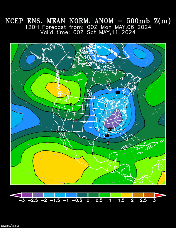
4.5 standard deviation 500 mb height anomaly forecasted for Saturday!
Last edited by austinrunner on Mon Jan 11, 2010 7:25 am, edited 1 time in total.
0 likes

Yikes! wow that's quite formidable...
0 likes
The above post and any post by Ntxw is NOT an official forecast and should not be used as such. It is just the opinion of the poster and may or may not be backed by sound meteorological data. It is NOT endorsed by any professional institution including Storm2k. For official information, please refer to NWS products.
Help support Storm2K!
-
srainhoutx

- S2K Supporter

- Posts: 6919
- Age: 68
- Joined: Sun Jan 14, 2007 11:34 am
- Location: Haywood County, NC
- Contact:
Re: Texas winter wx thread (2009-2010)
austinrunner wrote:5 standard deviation 500 mb height anomaly forecasted for Saturday!
This is why many of us are very concerned. We rarely see these types anomalies in Winter. This will likely be a major news maker in the days ahead IMHO.
0 likes
Carla/Alicia/Jerry(In The Eye)/Michelle/Charley/Ivan/Dennis/Katrina/Rita/Wilma/Ike/Harvey
Member: National Weather Association
Wx Infinity Forums
http://wxinfinity.com/index.php
Facebook.com/WeatherInfinity
Twitter @WeatherInfinity
Member: National Weather Association
Wx Infinity Forums
http://wxinfinity.com/index.php
Facebook.com/WeatherInfinity
Twitter @WeatherInfinity

Re: Texas winter wx thread (2009-2010)
austinrunner wrote:5 standard deviation 500 mb height anomaly forecasted for Saturday!
I have no idea what this is or what it means. It seems that it means a great deal. Can someone please be kind of enough to tell me what it means.....
0 likes
-
TrekkerCC

- S2K Supporter
- Posts: 263
- Joined: Sat Sep 06, 2003 10:19 pm
- Location: North Central Texas (Dallas Area)
Re: Texas winter wx thread (2009-2010)
txtiff wrote:I have no idea what this is or what it means. It seems that it means a great deal. Can someone please be kind of enough to tell me what it means.....
This chart shows deviations from the mean normal 500MB height. It is showing a very large area of below normal 500MB heights compared to the normal 500MB mean. Basically, it boils down to the fact that the upper level low will be very potent and likely to be a significant event (heavy rain for certain and for some areas this storm system may bring some snow).
0 likes
Storm2K Forecast Disclaimer:
This post is NOT AN OFFICIAL FORECAST and should not be used as such. It is just the opinion of the poster and may or may not be backed by sound meteorological data. It is NOT endorsed by any professional institution including storm2k.org. For Official Information please refer to the NHC and NWS products.
This post is NOT AN OFFICIAL FORECAST and should not be used as such. It is just the opinion of the poster and may or may not be backed by sound meteorological data. It is NOT endorsed by any professional institution including storm2k.org. For Official Information please refer to the NHC and NWS products.
-
goCoogs
- Tropical Low

- Posts: 38
- Joined: Mon Dec 22, 2008 9:52 am
- Location: Houston, TX I-10@ Greenhouse
Re: Texas winter wx thread (2009-2010)
I'm not sure what the map means either. I am an engineer though and I know what 5 standard deviations means. It means it is a very rare event. Correct me if I'm wrong, but doesn't 5 standard deviations mean the odds of this type of event occuring in any given year are 1 in 1,744,278?
0 likes
Re: Texas winter wx thread (2009-2010)
goCoogs wrote:I'm not sure what the map means either. I am an engineer though and I know what 5 standard deviations means. It means it is a very rare event. Correct me if I'm wrong, but doesn't 5 standard deviations mean the odds of this type of event occuring in any given year are 1 in 1,744,278?
The anomalies given are for forecast points in relation to observations taken every 6 hours. That is, what you see is a deviation from that climatic mean for observations that that have been taken every 6 hours for many years.
0 likes
-
goCoogs
- Tropical Low
- Posts: 38
- Joined: Mon Dec 22, 2008 9:52 am
- Location: Houston, TX I-10@ Greenhouse
Re: Texas winter wx thread (2009-2010)
Thanks for clearing that up with the anomolies. I was getting worried. If they are based on 6 hour observations it makes a lot more sense. I figured I was looking at it incorrectly.
0 likes
-
Texas Snowman
- Storm2k Moderator
- Posts: 6197
- Joined: Fri Jan 25, 2008 11:29 am
- Location: Denison, Texas
Re: Texas winter wx thread (2009-2010)
Bottom line seems to be that wet, frozen, or otherwise, a potentially memorable winter storm system may crank up off the Texas coast in a few days.
I like the term someone threw out a day or two ago, a potential Tex'easter.
I like the term someone threw out a day or two ago, a potential Tex'easter.
0 likes
The above post and any post by Texas Snowman is NOT an official forecast and should not be used as such. It is just the opinion of the poster and may or may not be backed by sound meteorological data. It is NOT endorsed by any professional institution including storm2k.org. For official information, please refer to NWS products.
-
srainhoutx
- S2K Supporter
- Posts: 6919
- Age: 68
- Joined: Sun Jan 14, 2007 11:34 am
- Location: Haywood County, NC
- Contact:
Re: Texas winter wx thread (2009-2010)
Larry Cosgrove thoughts tonight in the Houston Examiner...
http://www.examiner.com/x-3775-Houston- ... ry-11-2010
It may not make you stop grumbling about the incessant cold in Houston this winter, but I can tell you that temperatures will be milder over the next few days. Yes, readings will remain below seasonal normals through the next seven days, just not as low (deviations as much as -20 deg F from the mean) as the first 10 days of January.
That cheery notion aside, under lingering high pressure nocturnal values will again slip below freezing in most areas each of the next two nights. Frost and even localized ice fogs could form, so go extra slow on the bridges and overpasses between sundown and 8 AM.
By Wednesday, the complexion of our weather pattern changes, and not for the good. Computer models are locking in on the formation of a huge winter storm, originating in the subtropical jet stream over Mexico. Take a look at the 500MB forecast for Friday, January 15; it is very rare that you see a well-developed, close low over Mexico, but the idea of a trough axis ending over the Gulf of Tehuantepec is unreal! This feature will be loaded with moisture and energy, and the numerical outlooks suggest a grab of some remnant Arctic air as the surface low moves northeastward from Matamoras Mexico into the Columbus GA vicinity before reforming over the Virginia Capes. After torrential rain and gusty winds, Houston may see a brief mix or change to sleet and/or snow before the disturbance pulls away on January 16. This system may also produce a vicious ice storm in parts of Appalachia, the Piedmont and parts of MD an DE, with prominent snow threats from IN/OH/KY into WV/W MD/PA/NJ/S NY. On the GFS QPF chart, I have inserted prospective ice and snow changeover lines associated with this event.
I will try to post an updated storm track map concerning path and apparent weather possibilities in a special WEATHERAmerica update on Tuesday.
http://www.examiner.com/x-3775-Houston- ... ry-11-2010
0 likes
Carla/Alicia/Jerry(In The Eye)/Michelle/Charley/Ivan/Dennis/Katrina/Rita/Wilma/Ike/Harvey
Member: National Weather Association
Wx Infinity Forums
http://wxinfinity.com/index.php
Facebook.com/WeatherInfinity
Twitter @WeatherInfinity
Member: National Weather Association
Wx Infinity Forums
http://wxinfinity.com/index.php
Facebook.com/WeatherInfinity
Twitter @WeatherInfinity
-
srainhoutx
- S2K Supporter
- Posts: 6919
- Age: 68
- Joined: Sun Jan 14, 2007 11:34 am
- Location: Haywood County, NC
- Contact:
Re: Texas winter wx thread (2009-2010)
Here's the 250mb 00z GFS (flight level) Loop from the N Pacific. This is giving fits to guidance...
http://www.nco.ncep.noaa.gov/pmb/nwprod ... loop.shtml
http://www.nco.ncep.noaa.gov/pmb/nwprod ... loop.shtml
0 likes
Carla/Alicia/Jerry(In The Eye)/Michelle/Charley/Ivan/Dennis/Katrina/Rita/Wilma/Ike/Harvey
Member: National Weather Association
Wx Infinity Forums
http://wxinfinity.com/index.php
Facebook.com/WeatherInfinity
Twitter @WeatherInfinity
Member: National Weather Association
Wx Infinity Forums
http://wxinfinity.com/index.php
Facebook.com/WeatherInfinity
Twitter @WeatherInfinity
-
serenata09
- Tropical Storm

- Posts: 166
- Joined: Fri Jan 18, 2008 7:55 pm
- Location: Dallas, TX
Re: Texas winter wx thread (2009-2010)
So what is the latest model guidance telling us (specifically for the DFW area)? I've tried reading these maps but I don't think I'm that great at it. Correct me if I'm wrong but is the 00z GFS trending slightly colder for the time period we are discussing?
0 likes

Re: Texas winter wx thread (2009-2010)
I am also curious what this storm will bring to the north texas area.
0 likes
-
attallaman
Re: Texas winter wx thread (2009-2010)
Will this next system possibly bring temperatures as cold as or colder than what we're dealing with right now or will the lows with this next system be warmer? It's 27F here right now with a forecasted low of 19F right before sunrise.
0 likes
-
TrekkerCC
- S2K Supporter
- Posts: 263
- Joined: Sat Sep 06, 2003 10:19 pm
- Location: North Central Texas (Dallas Area)
Re: Texas winter wx thread (2009-2010)
attallaman wrote:Will this next system possibly bring temperatures as cold as or colder than what we're dealing with right now or will the lows with this next system be warmer? It's 27F here right now with a forecasted low of 19F right before sunrise.
The temperatures with this upcoming system will be much warmer. We have been under an air mass that had its origins in the arctic circle. Very bitter cold air. We may have some cold air entrained into this system, but it will not be brutally cold air like this past weekend has been.
0 likes
Storm2K Forecast Disclaimer:
This post is NOT AN OFFICIAL FORECAST and should not be used as such. It is just the opinion of the poster and may or may not be backed by sound meteorological data. It is NOT endorsed by any professional institution including storm2k.org. For Official Information please refer to the NHC and NWS products.
This post is NOT AN OFFICIAL FORECAST and should not be used as such. It is just the opinion of the poster and may or may not be backed by sound meteorological data. It is NOT endorsed by any professional institution including storm2k.org. For Official Information please refer to the NHC and NWS products.
-
attallaman
Re: Texas winter wx thread (2009-2010)
Well that's good Mr. TrekkerCC, mighty good.TrekkerCC wrote:attallaman wrote:Will this next system possibly bring temperatures as cold as or colder than what we're dealing with right now or will the lows with this next system be warmer? It's 27F here right now with a forecasted low of 19F right before sunrise.
The temperatures with this upcoming system will be much warmer. We have been under an air mass that had its origins in the arctic circle. Very bitter cold air. We may have some cold air entrained into this system, but it will not be brutally cold air like this past weekend has been.
0 likes
-
aerology
- Tropical Depression

- Posts: 56
- Age: 78
- Joined: Sun Oct 18, 2009 2:38 am
- Location: Concordia, Kansas
- Contact:
The following text was Originally Posted back on page 55 of this thread;
One of the problems with the current models is the reference time frame is very narrow for initial conditions, and changes with in the past three days, a lot of times, will introduce presistance of inertia, to the medial flows, for several days, consistent with the actual flows, as the Lunar declinational atmospheric tides, make their runs across the equator from one poleward culmination to another.
Then as the tide turns and we have the severe weather bursts at declinational culmination, they get confused, or surprised, as the initial inertial effects reverse for about four days before the sweep to the other pole, that brings back the smooth flows, the models understand.
So that when the Lunar declination went to Maximum North on December 3rd, turbulence and shear introduced into the atmosphere, from the turning tide, (the models do not know about), surprised them with the usual couple of tornadoes. Now (12-13-09) that we are ~20 degrees South Lunar declination, the models have a full buffer, of five days of linear inertial movement, from the Moon’s trip South across the equator (12-09-09) and is slowing it’s movement.
Coming up on the Southern extent culmination, producing a secondary tidal bulge in the Northern Hemisphere, bringing us to the mid point of a 27.32 day declinational cycle (one of the four routine patterns that cycle on an 109.3 day period). This particular one (#1) that started back on Dec 3rd, has incursions of polar air masses that come down from Western Canada, through Montana and the Dakotas, to make up the Northern part of the atmospheric tidal bulge.
So I would expect to see a large invasion of cold dry air sweep almost all the way to the Gulf coast again, then the produced frontal boundary with the interesting weather, that includes change state intense precipitation. Freezing rain, where the warm over runs cold, and snow where the cold undercuts the more sluggish warm air, still moving North East by inertia alone, severe weather to form in that trailing edge of the warm moist mass, that gets over taken from behind by the polar air mass that tries to follow the tidal bulge back to the equator, which for the next 4 of 5 days powers up the cyclonic patterns generated by carolis forces, and finishes out as the Moon approaches the equator again.
Expect the same type of interaction again for a primary bulge production by the passage back North, culminating on 12-30-09, pumping in a solid polar air mass very consistent with the pattern we had on 12-03-09, (the North “lunar declination culmination”)[LDC], then (#2) the next Rossby wave / jet stream regime pattern, comes back into play with much more zonal flow, and air masses invading from the Pacific, (of the two sub types of) phase with lesser amounts of Gulf moisture entrainment in this one, more in the other #4.
^added note> Now 1-11-2010 and the western half zonal flow is going strong, and because of the solar minimum the eastern half, is dipping South rather stronger than usual. So the trend should continue merrily through the type #3 pattern as well.
The (#3) third 27.32 day pattern with polar air masses invading in from the Minnesota / Great Lakes area and sweeping out through the Eastern sea board, and mostly zonal flow out west, from 01-27-10 till 02-23-10, comes next.
The fourth 27.32 day cycle, that looks very similar to #2 but with much more moisture from the Gulf of Mexico, usually has more hail and tornadoes associated with it than Pattern #4, and typically flows up Eastern side of tornado alley. Will be in effect from 02-23-10 through 03-22-10, and <b>should produce the first big surge of severe tornado production, from about March 20th 2010, until about March 26 or later</b> as the Next polar air mass cycle is coming out of western Canada, and should make for steep temperature gradients, and ion content differences.
Richard Holle
0 likes
Who is online
Users browsing this forum: No registered users and 52 guests