Deep South Winterwx Discussion 2015-2016
Moderator: S2k Moderators
Forum rules
 The posts in this forum are NOT official forecast and should not be used as such. They are just the opinion of the poster and may or may not be backed by sound meteorological data. They are NOT endorsed by any professional institution or STORM2K.

The posts in this forum are NOT official forecast and should not be used as such. They are just the opinion of the poster and may or may not be backed by sound meteorological data. They are NOT endorsed by any professional institution or STORM2K.
-
MGC

- S2K Supporter

- Posts: 5940
- Joined: Sun Mar 23, 2003 9:05 pm
- Location: Pass Christian MS, or what is left.
Re: Deep South Snow/Winterwx thread (2009-2010)
Hit 16 at my place....at least that is what the official MGC thermometer indicated. Hit 18 at the Gulfport airport. Noticed a good bit of ice on the bayou this morning. Doubt my palm and citrus survived. No piggly-wiggly eggnog....have an electric blanket though.....MGC
0 likes
-
mitchelliii
- Tropical Low

- Posts: 21
- Joined: Mon Jan 11, 2010 9:06 am
Re: Deep South Snow/Winterwx thread (2009-2010)
Anyone else see any winter weather headed down the pike for Georgia with all of the systems lined up out across the Pacific?
Cheers,
Cheers,
0 likes


Re: Deep South Snow/Winterwx thread (2009-2010)
12z GFS looking interesting next saturday!
192 hours:

204 hours:

216 hours:

192 hours:
204 hours:
216 hours:
0 likes
"It is better to live one day as a lion than a hundred years as a sheep"
-
Stormcenter
- S2K Supporter
- Posts: 6689
- Joined: Wed Sep 03, 2003 11:27 am
- Location: Houston, TX
Re: Deep South Snow/Winterwx thread (2009-2010)
Below is an interesting comment from this afternoon's (Jan.22) HPC extended forecast. 
http://www.hpc.ncep.noaa.gov/discussions/pmdepd.html
THE SRN STREAM CONTINUES ACTIVE. A SHORTWAVE TROUGH WILL MOVE
ACROSS THE SW CONUS WHICH SHOULD EVENTUALLY INDUCE A SURFACE LOW
TRACKING ACROSS THE GULF COAST REGION THE LATTER PORTION OF NEXT
WEEK. HAPPILY...THE NEW 12Z/22 UKMET AND UKMET ARE MUCH MORE
SUPPORTIVE OF OUR UPDATED PRELIM CONTINUITY IN THE SRN STREAM THAN
THE CORRESPONDING GFS. ALTHO THEY DO SHOW A DECENT ARCTIC
SHORTWAVE DROPPING S THRU CENTRAL CANADA IN THE DAY 3-4 TIME
FRAME...THEY TURN THE ENERGY EWD ACROSS THE NRN GREAT LAKES WED
DAY 5 RATHER THAN DROPPING IT S INTO THE OH VLY. THEY APPEAR ON
TARGET WITH OUR CONTINUITY IN BRINGING THE NEXT SRN STREAM
SHORTWAVE TOWARDS SRN CA BY EARLY WED...WHICH SUPPORTS OUR WAVE
OVER SW TX FOR THU DAY 6. THIS SYS COULD TAP GULF MOISTURE AND
BECOME AN IMPORTANT PRECIP PRODUCER BY FRI DAY 7 OVER THE SERN
CONUS...POSSIBLY WITH SN ON THE NRN EDGE OF THE PRECIP SHIELD.FLOOD
0 likes
-
aerology
- Tropical Depression

- Posts: 56
- Age: 79
- Joined: Sun Oct 18, 2009 2:38 am
- Location: Concordia, Kansas
- Contact:
Re: Deep South Snow/Winterwx thread (2009-2010)
mitchelliii wrote:Anyone else see any winter weather headed down the pike for Georgia with all of the systems lined up out across the Pacific?
Cheers,
Just a heads up....
We already had a spate of 14 Tornadoes (preliminary data total) on the 20th January 2010, just as the Moon crossed the equator headed North. Which brought in warmer moist air from the gulf, and a nice tight body of more polar, dry line air mass, mid afternoon to start things off. Expect another round the (Texas) 27th -30th (Ga, Al) January the same areas.
The following post is NOT an official forecast and should not be used as such. It is just the opinion of the poster and may or may not be backed by sound meteorological data. It is NOT endorsed by any professional institution including storm2k.org. For official information, please refer to NWS products.
As the moon will be maximum North on the 27th, the warm moist air it will drag with it, will clash with the cold air mass, the models are hinting at. The resultant wrap around mixing of the two, will generate a spate of severe weather, that sweeps across the SE / Gulf coast, with hail and tornadoes very possible the end of January 2010.
edited by vbhoutex to add disclaimer
0 likes
-
Brent
- S2K Supporter
- Posts: 38762
- Age: 37
- Joined: Sun May 16, 2004 10:30 pm
- Location: Tulsa Oklahoma
- Contact:
Re: Deep South Snow/Winterwx thread (2009-2010)
Friday Night...Colder...cloudy. A 30 percent chance of rain or snow in the evening. Lows in the upper 20s.

0 likes
#neversummer


Re: Deep South Snow/Winterwx thread (2009-2010)
Nashville NWS afternoon discussion:
AREA FORECAST DISCUSSION
NATIONAL WEATHER SERVICE NASHVILLE TN
244 PM CST SUN JAN 24 2010
.DISCUSSION...
RAIN AREA ALONG PLATEAU BEGINNING TO PULL EAST JUST AHEAD OF OCCLUSION.
ANOTHER BAND OF SHOWERS HAS STARTED TO DEVELOP ACROSS WESTERN MIDDLE
TN AT EARLY AFTERNOON. THIS BAND ASSOCIATED WITH A PREFRONTAL TROUGH
THAT EXTENDS DOWN THROUGH WESTERN MIDDLE TN. SURFACE COLD FRONT AT
19Z EXTENDS DOWN THROUGH MISSOURI OZARKS APPROACHING BOOTHEEL THEN
BACK INTO FAR NORTH CENTRAL TEXAS AND THEN INTO PAN HANDLE. CONTINENTAL
POLAR AIR MASS BEHIND THIS FRONT WILL INVADE MID STATE TONIGHT AND
WILL DRIVE TEMPS DOWN INTO THE 30S BY DAYBREAK. HAVE KEPT SHOWERS GOING
TONIGHT MORE NUMEROUS EAST WITH ISOLATED THUNDERSTORMS MAINLY DURING
THE EVENING. SHOWERS SHOULD DECREASE FROM THE WEST AFTER MIDNIGHT. INITAL
BITE OF COLD AIR NOT ALL THAT BAD AS SOUTHERN BRANCH OF THE POLAR
JET WILL BE QUITE ACTIVE THIS WEEK HELPING TO HOLD TEMPS UP ACROSS
THE SOUTH. THEN...AS NORTHERN POLAR VORTEX ROTATES SOUTH OF JAMES BAY
ABOUT MID-WEEK A GOOD SHOT OF COLD AIR GETS INJECTED THURSDAY INTO
SOUTHERN BRANCH WHICH THEN KICKS SURFACE LOW (INVERTED TROUGH) EAST
FROM LOUISIANA AND ACROSS THE SOUTH LAND BRINGING WHAT MAY VERY WELL
BE WINTRY PRECIP TO MIDDLE TENNESSEE BEGINNING THURSDAY AFTERNOON
IN THE NORTHWEST AND ACROSS ALL OF MIDDLE TENNESSEE THURSDAY NIGHT
INTO FRIDAY. THE EVENTUAL TRACK OF THE SURFACE LOW WILL BE A BIG
FACTOR AS USUAL. OUR PADUCAH OFFICE JUST INFORMED ME THAT IT WAS
ABOUT A YEAR AGO (JAN 27TH) THAT THE SEVERE ICE STORM OCCURRED IN
SOUTHWEST KY.
BOYD
0 likes
-
Brent
- S2K Supporter
- Posts: 38762
- Age: 37
- Joined: Sun May 16, 2004 10:30 pm
- Location: Tulsa Oklahoma
- Contact:
Re: Deep South Snow/Winterwx thread (2009-2010)
Friday Night: A chance of rain and snow. Mostly cloudy, with a low around 34. Chance of precipitation is 40%.
Saturday: A slight chance of rain and snow. Partly cloudy, with a high near 46. Chance of precipitation is 20%.
Saturday: A slight chance of rain and snow. Partly cloudy, with a high near 46. Chance of precipitation is 20%.
0 likes
#neversummer
Re: Deep South Snow/Winterwx thread (2009-2010)
Local Mets were predicting possible snow on Saturday???? (here in GA) 
0 likes
-
Brent
- S2K Supporter
- Posts: 38762
- Age: 37
- Joined: Sun May 16, 2004 10:30 pm
- Location: Tulsa Oklahoma
- Contact:
Re: Deep South Snow/Winterwx thread (2009-2010)
Cristina wrote:Local Mets were predicting possible snow on Saturday???? (here in GA)
It is possible. Not expecting much but it bears watching.
0 likes
#neversummer
-
Brent
- S2K Supporter
- Posts: 38762
- Age: 37
- Joined: Sun May 16, 2004 10:30 pm
- Location: Tulsa Oklahoma
- Contact:
Re: Deep South Snow/Winterwx thread (2009-2010)
Latest:
Friday Night: Rain likely, possibly mixed with snow and freezing rain. Cloudy, with a low around 31. Chance of precipitation is 70%.
Saturday: A slight chance of rain, snow, and freezing rain. Mostly cloudy, with a high near 41. Chance of precipitation is 20%.
Friday Night: Rain likely, possibly mixed with snow and freezing rain. Cloudy, with a low around 31. Chance of precipitation is 70%.
Saturday: A slight chance of rain, snow, and freezing rain. Mostly cloudy, with a high near 41. Chance of precipitation is 20%.
0 likes
#neversummer
-
Ivanhater

- Storm2k Moderator

- Posts: 11221
- Age: 39
- Joined: Fri Jul 01, 2005 8:25 am
- Location: Pensacola
Re: Deep South Snow/Winterwx thread (2009-2010)
Well looking at the extended, it looks like most of February for the deep south will be above normal, actually quite warm at times. I'm not complaining, I am looking forward to it!
0 likes
Michael
Re: Deep South Snow/Winterwx thread (2009-2010)
Well, I ain't in the DEEP South, but the Mid-South sure got a wintry mess! We've got a nice
layer of ice on top of 4-5" snow, and the tree limbs are leaning over to the ground and snapping.
There's trees and large limbs down, everywhere - icicles on the sagging power lines. Channel 4
out of Nashville is reporting 600 customers in Lawrence County without power right now...ours
is still on, for now - holding my breath! I shoveled a path to my frozen up car, and all you can
hear outside is trees groaning from the weight and snapping off, the occasional sound of a
chainsaw somewhere, and the snowplow making an occasional pass over on Highway 20...
It's eerie!
0 likes


-
attallaman
Re: Deep South Snow/Winterwx thread (2009-2010)
Can you post a pic?breeze wrote:Well, I ain't in the DEEP South, but the Mid-South sure got a wintry mess! We've got a nice
layer of ice on top of 4-5" snow, and the tree limbs are leaning over to the ground and snapping.
There's trees and large limbs down, everywhere - icicles on the sagging power lines. Channel 4
out of Nashville is reporting 600 customers in Lawrence County without power right now...ours
is still on, for now - holding my breath! I shoveled a path to my frozen up car, and all you can
hear outside is trees groaning from the weight and snapping off, the occasional sound of a
chainsaw somewhere, and the snowplow making an occasional pass over on Highway 20...
It's eerie!
0 likes
Re: Deep South Snow/Winterwx thread (2009-2010)
This is a poor quality cell phone shot of one of the trees in the backyard. I'm recharging my
cell phone right now and hope to get better pics tomorrow, especially with a bit more sunshine
and no gray skies!
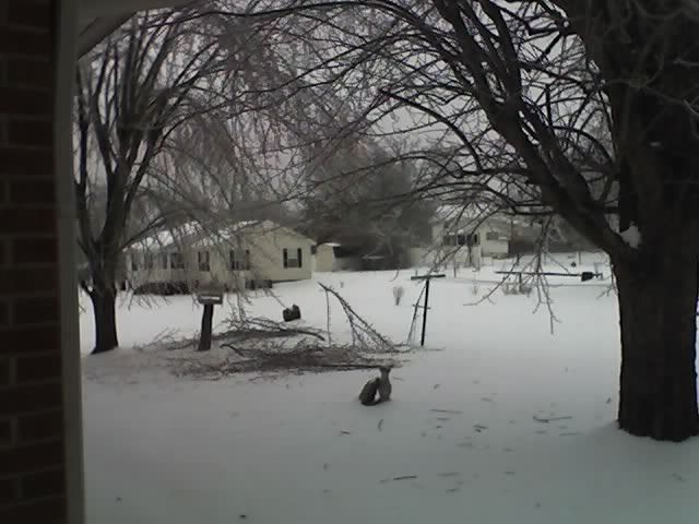
That's a tree laying over the neighbor's fence in the back of the photo!
cell phone right now and hope to get better pics tomorrow, especially with a bit more sunshine
and no gray skies!
That's a tree laying over the neighbor's fence in the back of the photo!
0 likes
-
attallaman
Re: Deep South Snow/Winterwx thread (2009-2010)
Not a bad pic for a cell phone. If you're able to recharge the phone consider posting another pic tomorrow if you could and I hope you don't lose your power during the night so you can stay warm because it does look cold there.breeze wrote:This is a poor quality cell phone shot of one of the trees in the backyard. I'm recharging my
cell phone right now and hope to get better pics tomorrow, especially with a bit more sunshine
and no gray skies!
That's a tree laying over the neighbor's fence in the back of the photo!
0 likes
-
Brent
- S2K Supporter
- Posts: 38762
- Age: 37
- Joined: Sun May 16, 2004 10:30 pm
- Location: Tulsa Oklahoma
- Contact:
Re: Deep South Snow/Winterwx thread (2009-2010)
*faints* after looking at the 0z GFS.
It can't be right.
Anyway...
Friday Night...Mostly cloudy with a 30 percent chance of rain and snow. Lows in the lower 30s.
 Another long sleep-deprived week.
The 0z GFS taken verbatim is an epic ice and snowstorm for the entire east coast from the Deep South to the Northeast, and lasts several days. Areas just buried by this storm get walloped again.
It can't be right.
Anyway...
Friday Night...Mostly cloudy with a 30 percent chance of rain and snow. Lows in the lower 30s.
Another long sleep-deprived week.The 0z GFS taken verbatim is an epic ice and snowstorm for the entire east coast from the Deep South to the Northeast, and lasts several days. Areas just buried by this storm get walloped again.
0 likes
#neversummer
Re: Deep South Snow/Winterwx thread (2009-2010)
Took a few more pics from my cell phone...a good digital camera is certainly on my "I Want One of Those" List for this year! 
Took this yesterday - I worked at shoveling away a sheet of ice to get to my car, then I
couldn't get in it because the door was frozen shut!
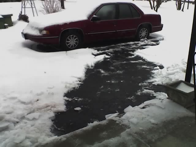
Ice on the lines, taken from the porch, this morning:
Took this yesterday - I worked at shoveling away a sheet of ice to get to my car, then I
couldn't get in it because the door was frozen shut!
Ice on the lines, taken from the porch, this morning:
0 likes
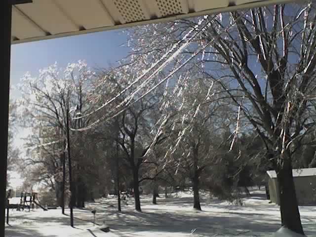
Re: Deep South Snow/Winterwx thread (2009-2010)
Maple tree limbs coated in ice - you can see where the ice is falling beneath the tree, now.
It's doing a good job of melting, this afternoon, as temps warmed into the mid-30°F range,
which was over the forecast high of 32°F.
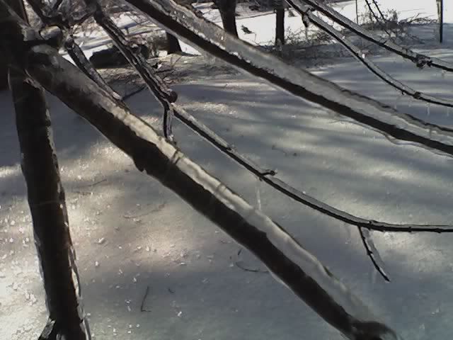
It's doing a good job of melting, this afternoon, as temps warmed into the mid-30°F range,
which was over the forecast high of 32°F.
0 likes
Who is online
Users browsing this forum: No registered users and 80 guests