Texas winter wx thread (2009-2010)

Winter Weather Discussion

Moderator: S2k Moderators

Forum rules

The posts in this forum are NOT official forecast and should not be used as such. They are just the opinion of the poster and may or may not be backed by sound meteorological data. They are NOT endorsed by any professional institution or STORM2K.

Help Support Storm2K
Message
Author
HockeyTx82
S2K Supporter
S2K Supporter
Posts: 2542
Joined: Tue Oct 27, 2009 11:17 am
Location: Ponder, TX

Re: Texas winter wx thread (2009-2010)

#4441 Postby HockeyTx82 » Tue Jan 26, 2010 4:44 pm

Well the temps have gone up a bit on Thursday night but way down for the high on Friday. Also the precip chances went from rain to wintry mix with higer chances. Something is going on.......

http://forecast.weather.gov/MapClick.ph ... 2=-97.1309

:froze:
0 likes   
Don't hold me accountable for anything I post on this forum. Leave the real forecasting up to the professionals.

Location: Ponder, TX (all observation posts are this location unless otherwise noted)

User avatar
somethingfunny
ChatStaff
ChatStaff
Posts: 3926
Age: 37
Joined: Thu May 31, 2007 10:30 pm
Location: McKinney, Texas

Re: Texas winter wx thread (2009-2010)

#4442 Postby somethingfunny » Tue Jan 26, 2010 4:45 pm

So wxman, msstateguy, wall_cloud and others, if I decide to warm up the car and go on a snow chase, where would you suggest I go?
0 likes   

WacoWx
Category 2
Category 2
Posts: 664
Joined: Mon Dec 28, 2009 4:14 pm
Location: NOT Waco, TX ----> Dallas, TX

Re: Texas winter wx thread (2009-2010)

#4443 Postby WacoWx » Tue Jan 26, 2010 4:50 pm

if it were me, i'd go to Aspen or Vail. :ggreen:
0 likes   

msstateguy83

Re: Texas winter wx thread (2009-2010)

#4444 Postby msstateguy83 » Tue Jan 26, 2010 4:50 pm

000
FXUS64 KOUN 262142
AFDOUN

AREA FORECAST DISCUSSION
NATIONAL WEATHER SERVICE NORMAN OK
342 PM CST TUE JAN 26 2010

.DISCUSSION...
UPPER LOW THAT WILL BRING A VARIETY OF WINTER WEATHER IS
LOCATED SEVERAL HUNDRED MILES OFF THE SOUTHERN CALIFORNIA COAST
LATE THIS AFTERNOON. TONIGHT...HIGH CLOUDS WILL THICKEN ACROSS
THE FA WITHIN A WEST TO SOUTHWEST FLOW... WHILE LOW CLOUDS ACROSS
SOUTH TEXAS LIFT NORTH OVERNIGHT. ON WEDNESDAY...INITIAL SURGE OF
MUCH COLDER AIR WILL ENTER FAR NORTHWEST OKLAHOMA AROUND NOON.
BREEZY SOUTHWEST WINDS AHEAD OF THE FRONT WILL PROVIDE RATHER WARM
CONDITIONS ACROSS A LARGE PART OF THE FA.

COLD FRONT WILL CONTINUE TO PUSH SOUTHWARD WEDNESDAY NIGHT AND
SHOULD BE SOUTH OF MOST AREAS BY EARLY THURSDAY MORNING. RAIN
SHOWERS WILL LIKELY DEVELOP NEAR FRONTAL ZONE DURING THE
OVERNIGHT PERIOD ACROSS SOUTHERN OKLAHOMA...WESTERN NORTH TEXAS.

PRECIPITATION WILL BECOME WIDESPREAD DURING THE DAY THURSDAY AS UPPER
LOW MOVES NORTHEAST. SIGNIFICANT PRECIPITATION AMOUNTS APPEAR LIKELY
FOR A LARGE PART OF FA. STILL A CHALLENGING (PRECIP-TYPE) FORECAST
BUT MAINLY USED THE 12Z NAM THERMAL STRUCTURE FOR (TYPE--- CHANGE
OVER) WITH COLDER GFS SURFACE NUMBERS.

AREAS NORTH AND WEST OF HOBART...EL RENO...STILLWATER WILL HAVE
BEST CHANCE OF ACCUMULATING SNOW WITH SLEET. AREAS SOUTH AND EAST
OF SEMINOLE...DUNCAN...AND WICHITA FALLS WILL HAVE BEST
OPPORTUNITY OF HIGHER ICE ACCUMULATIONS. FAR SOUTHEAST OKLAHOMA
MAY SEE MAINLY A COLD RAIN WITH SOME SLEET AND SNOW AS PRECIP
ENDS.

AFTER FRIDAY...TEMPERATURES WILL REMAIN VERY COLD INTO SUNDAY WITH
NO ADDITIONAL PRECIP. ANOTHER SHORTWAVE WILL BRING A CHANCE OF MAINLY
LIGHT RAIN TO EASTERN PARTS OF FA ON MONDAY.
0 likes   

msstateguy83

#4445 Postby msstateguy83 » Tue Jan 26, 2010 4:52 pm

per oun's latest forecast disc expect the front passed thru most of the fa by early thu am.. so could be well into n.tx by that time... iam telling you that front is key to this whole puzzle......
0 likes   

User avatar
wxman57
Moderator-Pro Met
Moderator-Pro Met
Posts: 22991
Age: 67
Joined: Sat Jun 21, 2003 8:06 pm
Location: Houston, TX (southwest)

Re: Texas winter wx thread (2009-2010)

#4446 Postby wxman57 » Tue Jan 26, 2010 4:52 pm

OK, 18Z NAM fully in. Let's compare the 18Z run to the 12Z.

First for SPS. 18Z NAM is MUCH drier in the cold air than the 12Z run

18Z NAM for SPS:
Image

12Z NAM for SPS:
Image

Now, for DFW. Both runs are fairly dry for GFS in the cold air. The 18Z NAM is also a few degrees warmer for DFW on Friday:

18Z NAM for DFW:
Image

12Z NAM for DFW:
Image

So the trends in both the GFS and NAM from 12Z to 18Z are a little drier and a little warmer for the DFW to SPS area for Friday. I.E., they're both trending toward less freezing/frozen precip.

However, Wichita Falls may be pretty close to some heavier snow amounts.

What'll really tell the story as far as precip types will be the vertical temperature profiles. Don't have time to run them now, as I'm about ready to go home. Will look at them from home this evening.
0 likes   

Weatherdude20

Re: Texas winter wx thread (2009-2010)

#4447 Postby Weatherdude20 » Tue Jan 26, 2010 4:57 pm

HockeyTx82 wrote:Well the temps have gone up a bit on Thursday night but way down for the high on Friday. Also the precip chances went from rain to wintry mix with higer chances. Something is going on.......

http://forecast.weather.gov/MapClick.ph ... 2=-97.1309

:froze:


Thats what confused me, haha I just think the NWSFO is confused...
0 likes   

HockeyTx82
S2K Supporter
S2K Supporter
Posts: 2542
Joined: Tue Oct 27, 2009 11:17 am
Location: Ponder, TX

Re: Texas winter wx thread (2009-2010)

#4448 Postby HockeyTx82 » Tue Jan 26, 2010 5:01 pm

Weatherdude20 wrote:
HockeyTx82 wrote:Well the temps have gone up a bit on Thursday night but way down for the high on Friday. Also the precip chances went from rain to wintry mix with higer chances. Something is going on.......

http://forecast.weather.gov/MapClick.ph ... 2=-97.1309

:froze:


Thats what confused me, haha I just think the NWSFO is confused...


As little as I know, and trust me I don't know very much about weather, it just seems that there are so many things that have to come together for this thing to happen. The Christmas Eve storm snuck up on everyone and really came down. Does this one pose the same? Perhaps? When should we have a clearer picture of what to expect other then when it gets here and does what it is going to do............?
0 likes   
Don't hold me accountable for anything I post on this forum. Leave the real forecasting up to the professionals.

Location: Ponder, TX (all observation posts are this location unless otherwise noted)

msstateguy83

Re: Texas winter wx thread (2009-2010)

#4449 Postby msstateguy83 » Tue Jan 26, 2010 5:01 pm

someone who can look @ the gfs temp data for me iam looking over precip as it comes in..
0 likes   

msstateguy83

Re: Texas winter wx thread (2009-2010)

#4450 Postby msstateguy83 » Tue Jan 26, 2010 5:01 pm

48 hrs out... NEW GFS RUN....

Image
0 likes   

HockeyTx82
S2K Supporter
S2K Supporter
Posts: 2542
Joined: Tue Oct 27, 2009 11:17 am
Location: Ponder, TX

Re: Texas winter wx thread (2009-2010)

#4451 Postby HockeyTx82 » Tue Jan 26, 2010 5:03 pm

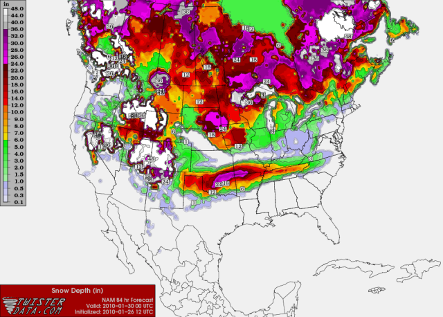
msstateguy83 wrote:48 hrs out... NEW GFS RUN....

Image


So is it safe to say at this point we will have more then enough moisture? Just a matter of what type of precip falls in your area?
0 likes   
Don't hold me accountable for anything I post on this forum. Leave the real forecasting up to the professionals.

Location: Ponder, TX (all observation posts are this location unless otherwise noted)

Weatherdude20

Re: Texas winter wx thread (2009-2010)

#4452 Postby Weatherdude20 » Tue Jan 26, 2010 5:05 pm

HockeyTx82 wrote:
Weatherdude20 wrote:
HockeyTx82 wrote:Well the temps have gone up a bit on Thursday night but way down for the high on Friday. Also the precip chances went from rain to wintry mix with higer chances. Something is going on.......

http://forecast.weather.gov/MapClick.ph ... 2=-97.1309

:froze:


Thats what confused me, haha I just think the NWSFO is confused...


As little as I know, and trust me I don't know very much about weather, it just seems that there are so many things that have to come together for this thing to happen. The Christmas Eve storm snuck up on everyone and really came down. Does this one pose the same? Perhaps? When should we have a clearer picture of what to expect other then when it gets here and does what it is going to do............?


Yes, it has the potential to rapidly change for the worse, and hopefully the new data is coming in anytime now, so analyzations will be done soon as well.
0 likes   

msstateguy83

Re: Texas winter wx thread (2009-2010)

#4453 Postby msstateguy83 » Tue Jan 26, 2010 5:05 pm

exactly... thats been my point thats why i have been so dang animated about this and to the point, hopefully people on here that listen to us are catching on *IF* the front comes thru early enough this could all spell MAJOR, MAJOR AND I MEAN MAJOR problems with ice & snow... if the air is cold enough in the upper levels it could be a major snowstorm unlike we have seen...
0 likes   

msstateguy83

#4454 Postby msstateguy83 » Tue Jan 26, 2010 5:06 pm

weatherdude if you can grab some temp readings for me if you can from this run iam goin over all the precip data closely...
0 likes   

msstateguy83

Re: Texas winter wx thread (2009-2010)

#4455 Postby msstateguy83 » Tue Jan 26, 2010 5:08 pm

Image

Image
Image
Image
Image
0 likes   

Weatherdude20

Re: Texas winter wx thread (2009-2010)

#4456 Postby Weatherdude20 » Tue Jan 26, 2010 5:11 pm

Well 27 for Wichita Falls at that time.
0 likes   

User avatar
Ntxw
Storm2k Moderator
Storm2k Moderator
Posts: 22792
Joined: Wed Oct 21, 2009 6:34 pm
Location: DFW, Texas

Re: Texas winter wx thread (2009-2010)

#4457 Postby Ntxw » Tue Jan 26, 2010 5:11 pm

FW

...WINTER RETURNS THURSDAY NIGHT AND FRIDAY...

A POWERFUL UPPER LEVEL STORM SYSTEM WILL MOVE THROUGH THE SOUTHERN
PLAINS AND BRING A PERIOD OF UNSETTLED WEATHER AND COLDER
TEMPERATURES TO NORTH TEXAS. MOISTURE AND LIFT AHEAD OF THE UPPER
LEVEL SYSTEM WILL RESULT IN WIDESPREAD RAIN AND A FEW
THUNDERSTORMS THURSDAY AND INTO THURSDAY NIGHT. RAINFALL AMOUNTS
WILL AVERAGE 1 TO 2 INCHES...WITH TOTALS UP TO 3 INCHES POSSIBLE
NORTH OF THE I-20 CORRIDOR.

MEANWHILE A STRONG COLD FRONT WILL MOVE SOUTH ACROSS NORTH TEXAS
THURSDAY AND THURSDAY NIGHT. AS TEMPERATURES COOL BEHIND THE
FRONT...THE RAIN SHOULD CHANGE OVER TO A LIGHT WINTRY MIX OF
PRECIPITATION TO THE NORTHWEST OF A LINE FROM LAMPASAS...TO
WACO...TO TERRELL...TO SULPHUR SPRINGS BY FRIDAY MORNING. SOME
MINOR ACCUMULATIONS OF ICE OCCURRING FROM LIGHT FREEZING DRIZZLE
WILL BE POSSIBLE FRIDAY MORNING...ESPECIALLY NORTHWEST OF A LINE
FROM COMANCHE...TO WEATHERFORD...TO GAINESVILLE WHERE SURFACE
TEMPERATURES WILL DROP INTO THE UPPER 20S.

THE MOST SIGNIFICANT WINTER PRECIPITATION IS EXPECTED TO REMAIN
OVER THE TEXAS PANHANDLE AND OKLAHOMA WHERE THE CENTER OF UPPER
LEVEL STORM SYSTEM IS FORECAST TO TRACK. HOWEVER...DUE TO
UNCERTAINTIES ON THE EXACT TRACK OF THE SYSTEM...RESIDENTS
ACROSS NORTH TEXAS ARE ENCOURAGED TO MONITOR THE LATEST FORECASTS
FOR ANY CHANGES DURING THE NEXT COUPLE OF DAYS.
0 likes   
The above post and any post by Ntxw is NOT an official forecast and should not be used as such. It is just the opinion of the poster and may or may not be backed by sound meteorological data. It is NOT endorsed by any professional institution including Storm2k. For official information, please refer to NWS products.

  Help support Storm2K!
Help Support Storm2K

msstateguy83

#4458 Postby msstateguy83 » Tue Jan 26, 2010 5:13 pm

if you go by snow depth charts on twisterdata it puts all the heavy snow up north.. but sometimes you gotta use your brains... surface temps, upper level temps @ that time,exc,exc....
0 likes   

msstateguy83

Re: Texas winter wx thread (2009-2010)

#4459 Postby msstateguy83 » Tue Jan 26, 2010 5:19 pm

this has moved further se from the 12z run will post shortly...

TOP ONE IS 12Z BOTTOM 18Z

Image

Image
Last edited by msstateguy83 on Tue Jan 26, 2010 5:22 pm, edited 1 time in total.
0 likes   

User avatar
somethingfunny
ChatStaff
ChatStaff
Posts: 3926
Age: 37
Joined: Thu May 31, 2007 10:30 pm
Location: McKinney, Texas

Re: Texas winter wx thread (2009-2010)

#4460 Postby somethingfunny » Tue Jan 26, 2010 5:21 pm

I'm concerned by the forecasts of 3"+ of rain before the front moves through. That would bring some localized flooding problems for sure.

With that much water saturated into the ground I would think that it would take quite some time for the ground to reach freezing even after the air temperature dips below freezing, so I don't anticipate any accumulations of ice or snow except perhaps on overpasses.

*Referring to the DFW area, that is.
0 likes   


Return to “Winter Weather”

Who is online

Users browsing this forum: No registered users and 40 guests