ENSO Updates (2007 thru 2023)
Moderator: S2k Moderators
Forum rules
The posts in this forum are NOT official forecasts and should not be used as such. They are just the opinion of the poster and may or may not be backed by sound meteorological data. They are NOT endorsed by any professional institution or STORM2K. For official information, please refer to products from the National Hurricane Center and National Weather Service.
- cycloneye
- Admin

- Posts: 149151
- Age: 69
- Joined: Thu Oct 10, 2002 10:54 am
- Location: San Juan, Puerto Rico
Re: ENSO Updates=CPC 1/25/10=El Nino sst anomalies decrease
The below graphic updates daily.It shows decreasing anomalies from 120W eastward but still warmer areas west of that longitud.That kind of setup is called a Modoki El Nino.


0 likes
Visit the Caribbean-Central America Weather Thread where you can find at first post web cams,radars
and observations from Caribbean basin members Click Here
and observations from Caribbean basin members Click Here
Re: ENSO Updates=CPC 1/25/10=El Nino sst anomalies decrease
0 likes
- Blown Away
- S2K Supporter

- Posts: 10253
- Joined: Wed May 26, 2004 6:17 am
Re: ENSO Updates=CPC 1/25/10=El Nino sst anomalies decrease
Macrocane wrote::uarrow: Like the one that occured on 2004, if it becomes a Modoki El Niño the Atl hurricane season won't be as slow as it was last year but we cannot say that it will be like the 2004 season wich was a very rare occurence.
Which of the 2010 Atlantic hurricane season analog years (52,58,64,66,98,2003,2007) had a Modoki El Nino type event the year before? If these analog years are accurate it could be a very active season the E Carribean and SFL.
0 likes
Hurricane Eye Experience: David 79, Irene 99, Frances 04, Jeanne 04, Wilma 05… Hurricane Brush Experience: Andrew 92, Erin 95, Floyd 99, Matthew 16, Irma 17, Ian 22, Nicole 22…
Re: ENSO Updates=El Nino to last thru late spring / early summer
I think none of those years would be considered analog if El Niño Modoki persists during this year because last year was a typical El Niño and now it would be transtitioning to modoki. But to answer your question, I think that only 2003 had a Modoki El Niño the year before, if those analog years that you mentioned end up being correct we will have an active hurricane season.
0 likes
- cycloneye
- Admin

- Posts: 149151
- Age: 69
- Joined: Thu Oct 10, 2002 10:54 am
- Location: San Juan, Puerto Rico
Re: ENSO Updates=El Nino to last thru late spring / early summer
Another year that had a "Modoki El Nino" was 2004 and you can see that it was an active season.


0 likes
Visit the Caribbean-Central America Weather Thread where you can find at first post web cams,radars
and observations from Caribbean basin members Click Here
and observations from Caribbean basin members Click Here
Re: ENSO Updates=El Nino to last thru late spring / early summer
The only prior year that would be considered "el Nino Modoki" would be 2002 ... and 2003 was not exceptional
0 likes
Re: ENSO Updates=El Nino to last thru late spring / early summer
hcane wrote:The only prior year that would be considered "el Nino Modoki" would be 2002 ... and 2003 was not exceptional
Actually it was pretty active, not as active as 2004 and 2005 but way more active than the average.
0 likes
- cycloneye
- Admin

- Posts: 149151
- Age: 69
- Joined: Thu Oct 10, 2002 10:54 am
- Location: San Juan, Puerto Rico
Re: ENSO Updates=El Nino to last thru late spring / early summer
2003 had a very active Cape Verde season and well above the average in general.


0 likes
Visit the Caribbean-Central America Weather Thread where you can find at first post web cams,radars
and observations from Caribbean basin members Click Here
and observations from Caribbean basin members Click Here
- cycloneye
- Admin

- Posts: 149151
- Age: 69
- Joined: Thu Oct 10, 2002 10:54 am
- Location: San Juan, Puerto Rico
Re: ENSO Updates=El Nino to last thru late spring / early summer
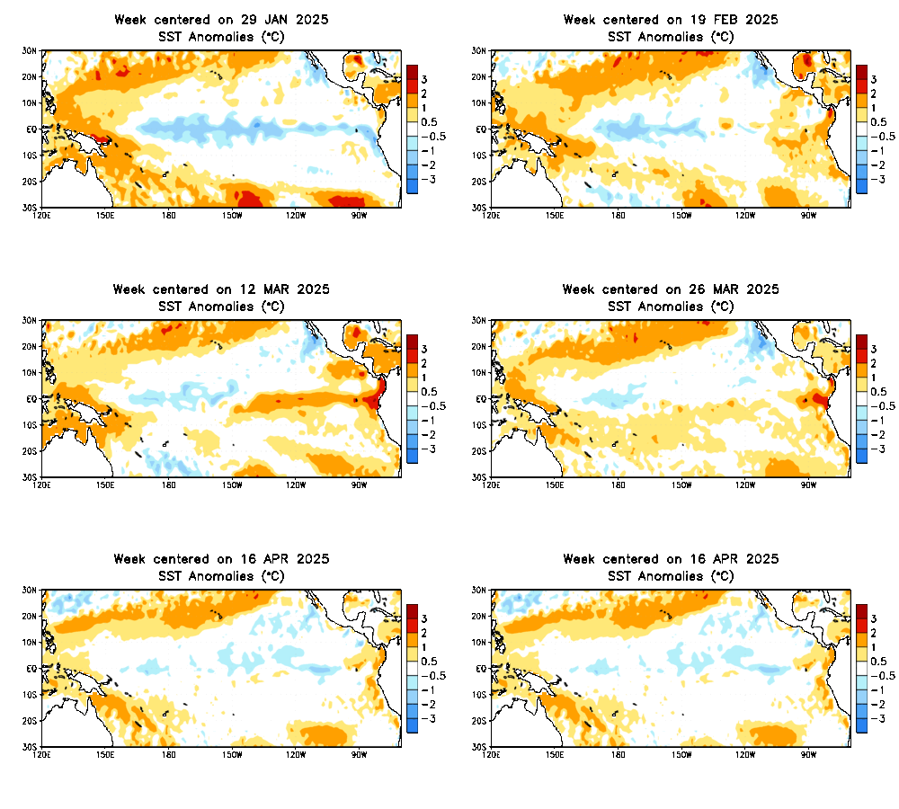
El Nino has weakened some as you can see in the loop.As the updates from the Australians and Climate Prediction Center have said,El Nino may have peaked.Lets continue to watch the progress of ENSO to see if a trend towards El Nino weakening sustains or is a blip.

0 likes
Visit the Caribbean-Central America Weather Thread where you can find at first post web cams,radars
and observations from Caribbean basin members Click Here
and observations from Caribbean basin members Click Here
Re: ENSO Updates=El Nino to last thru late spring / early summer
The higher the + sst anomaly, the stronger the el nino is.....clearly there has been a steady weakening trend of the current el nino since the peak reached at the end of December:
Nino Region 3.4 SST anomaly:
12/28/09 = +1.9C
1/4/10 = +1.8C
1/11/10 = +1.8C
1/18/10 = +1.7C
1/25/10 = +1.4C
An anomaly of under +0.5C down to -0.5C is considered enso neutral....neither el nino nor la nina. The key this spring will be to see if conditions approach enso neutral by the time the hurricane season really gets going climatologically in August.
0 likes
Re: ENSO Updates=El Nino thru late spring or early summer
The Nino appears to be fading, but someone forgot to tell the SOI
Code: Select all
  Date            Tahiti    Darwin   Daily**    30 day    90 day
                                                Av.SOI    Av.SOI
----------------------------------------------------------------
  3-Jan-2010     1010.21   1004.65      4.48     -7.08    -10.10
  4-Jan-2010     1009.00   1001.40     14.09     -6.21     -9.96
  5-Jan-2010     1008.29   1001.20     11.69     -5.66     -9.87
  6-Jan-2010     1007.78   1003.90     -3.43     -5.54     -9.86
  7-Jan-2010     1008.26   1004.90     -5.88     -5.48     -9.78
  8-Jan-2010     1007.59   1005.25    -10.69     -5.79     -9.72
  9-Jan-2010     1005.25   1005.40    -22.42     -6.74     -9.76
  10-Jan-2010    1003.05   1005.75    -34.43     -8.02     -9.96
  11-Jan-2010    1004.13   1005.15    -26.52     -9.23    -10.16
  12-Jan-2010    1007.93   1004.35     -4.85     -9.40    -10.20
  13-Jan-2010    1009.83   1005.80     -2.73     -9.13    -10.21
  14-Jan-2010    1010.86   1007.55     -6.12     -8.64    -10.14
  15-Jan-2010    1011.81   1007.85     -3.06     -7.78     -9.81
  16-Jan-2010    1010.99   1006.75     -1.74     -6.83     -9.37
  17-Jan-2010    1010.65   1006.05     -0.04     -5.88     -8.93
  18-Jan-2010    1010.10   1006.90     -6.64     -5.15     -8.64
  19-Jan-2010    1010.00   1008.15    -13.00     -4.60     -8.46
  20-Jan-2010    1010.53   1009.40    -16.39     -4.22     -8.38
  21-Jan-2010    1010.71   1008.90    -13.18     -3.92     -8.24
  22-Jan-2010    1010.99   1008.95    -12.10     -3.50     -8.16
  23-Jan-2010    1011.06   1009.05    -12.24     -3.36     -8.04
  24-Jan-2010    1011.26   1007.85     -5.65     -3.27     -7.89
  25-Jan-2010    1010.90   1006.95     -3.10     -3.38     -7.69
  26-Jan-2010    1010.00   1006.05     -3.10     -3.69     -7.42
  27-Jan-2010    1008.15   1005.55     -9.46     -4.51     -7.30
  28-Jan-2010    1006.18   1005.25    -17.33     -5.59     -7.41
  29-Jan-2010    1006.51   1004.25    -11.06     -6.03     -7.40
  30-Jan-2010    1005.41   1004.75    -18.60     -7.11     -7.43
  31-Jan-2010    1001.99   1006.40    -42.49     -8.90     -7.71
  1-Feb-2010      999.10   1006.45    -58.07    -11.14     -8.23
0 likes
- cycloneye
- Admin

- Posts: 149151
- Age: 69
- Joined: Thu Oct 10, 2002 10:54 am
- Location: San Juan, Puerto Rico
Re: ENSO Updates=El Nino thru late spring or early summer
0 likes
Visit the Caribbean-Central America Weather Thread where you can find at first post web cams,radars
and observations from Caribbean basin members Click Here
and observations from Caribbean basin members Click Here
- cycloneye
- Admin

- Posts: 149151
- Age: 69
- Joined: Thu Oct 10, 2002 10:54 am
- Location: San Juan, Puerto Rico
Re: ENSO Updates=El Nino thru late spring or early summer
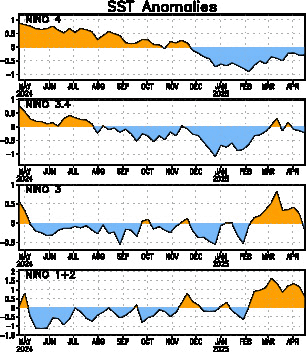
Climate Prediction Center Weekly 2/1/10 Update
El Nino 3-4 area continues a steady decrease in its numbers making El Nino Moderate taking away the wording "strong to moderate".
Last Week Numbers
Niño 4= +1.4ºC
Niño 3.4= +1.4ºC
Niño 3= +0.8ºC
Niño1+2= +0.1ºC
This Week Numbers
Niño 4= +1.3ºC
Niño 3.4= +1.2ºC
Niño 3= +0.7ºC
Niño1+2= +0.4ºC
http://www.cpc.ncep.noaa.gov/products/a ... ts-web.pdf

0 likes
Visit the Caribbean-Central America Weather Thread where you can find at first post web cams,radars
and observations from Caribbean basin members Click Here
and observations from Caribbean basin members Click Here
-
HURRICANELONNY
- Category 5

- Posts: 1390
- Joined: Wed May 07, 2003 6:48 am
- Location: HOLLYWOOD.FL
- cycloneye
- Admin

- Posts: 149151
- Age: 69
- Joined: Thu Oct 10, 2002 10:54 am
- Location: San Juan, Puerto Rico
Re: ENSO Updates=Models forecast Neutral by early summer
Australians 3rd of Febuary ENSO Update
Details
The Pacific Ocean sea surface temperature (SST) remains warmer than the long-term average across the central and eastern tropical Pacific. The SST anomaly map for January shows warm anomalies in excess of +1°C covering most of the tropical Pacific east of the dateline, with anomalies exceeding +2°C in parts of the central Pacific. The map also shows near-normal SSTs covering most of the western Pacific and northern waters around Australia. The monthly NINO indices for January were +1.1°C, +1.5°C and +1.2°C for NINO3, NINO3.4 and NINO4 respectively. All NINO indices cooled in relation to the December anomalies.
In terms of weekly data, the most recent NINO indices are +0.9°C, +1.2°C and +1.0°C for NINO3, NINO3.4 and NINO4 respectively. When compared with two weeks ago, each of the NINO indices has cooled slightly; NINO3 and NINO4 cooled by approximately 0.3°C, and NINO3.4 by approximately 0.5°C. The 7-day SST anomaly map shows warm anomalies in excess of +1°C covering most of the tropical Pacific east of 170°E, while ocean temperatures are more than 2°C above average between the date-line and 140°W. When compared with anomalies observed a fortnight ago, the central and eastern Pacific sea surface has cooled slightly. An animation of recent SST changes is available.
A four-month sequence of sub-surface Pacific Ocean equatorial temperature anomaly shows a peak in sub-surface warmth during November, with anomalies in excess of +4°C evident between 110°W and 140°W. During December and January, weak cool anomalies propogated eastwards displacing some of the warm anomalies along the thermocline, particuarly in the central Pacific. A recent map for the 5 days ending 1 February shows that a large volume of warmer than normal water persists below the surface of the tropical Pacific east of the dateline, with anomalies exceeding +3°C in the eastern Pacific. When compared with two weeks ago, the sub-surface of the equatorial Pacific has slightly cooled. An animation of recent sub-surface changes is available.
An archive of past SST and sub-surface temperature charts is available.
Trade winds have weakened significantly during the last fortnight, with a strong westerly wind burst observed over the western Pacific. Westerly wind anomalies are now evident across both the central and western equatorial Pacific. Trade winds remain stronger than normal in the eastern Pacific after strengthening in early January. The latest weekly wind anomalies are shown in the TAO/TRITON map (small image above) for the five days ending 1 February.
The SOI increased slowly through January, after being relatively stable for most of December. The SOI dropped rapidly during the last week due to a sharp decline in the MSLP over Tahiti. This fall in the SOI is due to the strong westerly wind anomalies in the central Pacific. The current 30-day SOI value (1 February) is −13. The monthly value for January was −10.
Daily SOI Index
http://www.longpaddock.qld.gov.au/Seaso ... SOIValues/
Cloudiness near the date-line across the equatorial Pacific is another important indicator of El Niño conditions, as it typically increases near and to the east of the dateline during these episodes. Cloudiness near the dateline increased during the last two months with recent high levels coinciding with a westerly wind burst currently over the western and central Pacific.
Most international computer models are predicting that the warm tropical Pacific Ocean temperatures will persist in El Niño regions over the remainder of the southern hemisphere summer and into autumn. The majority of models are predicting a gradual cooling of SSTs by April and a return to neutral conditions by the southern hemisphere autumn or winter. Typically, autumn is a transitional period for ENSO, hence model predictions of El Niño that forecast through this period are less reliable than at other times of the year. Recent forecasts from the POAMA model, run daily at the Bureau of Meteorology, show a gradual cooling with SSTs returning to neutral conditions during the southern hemisphere winter.
0 likes
Visit the Caribbean-Central America Weather Thread where you can find at first post web cams,radars
and observations from Caribbean basin members Click Here
and observations from Caribbean basin members Click Here
- cycloneye
- Admin

- Posts: 149151
- Age: 69
- Joined: Thu Oct 10, 2002 10:54 am
- Location: San Juan, Puerto Rico
Re: ENSO Updates=Models forecast Neutral by early summer
Models forecast Neutral ENSO by early summer
This is a more solid consensus of the ENSO models that I have seen in a while.
http://www.bom.gov.au/climate/ahead/ENSO-summary.shtml
This is a more solid consensus of the ENSO models that I have seen in a while.
http://www.bom.gov.au/climate/ahead/ENSO-summary.shtml
0 likes
Visit the Caribbean-Central America Weather Thread where you can find at first post web cams,radars
and observations from Caribbean basin members Click Here
and observations from Caribbean basin members Click Here
- cycloneye
- Admin

- Posts: 149151
- Age: 69
- Joined: Thu Oct 10, 2002 10:54 am
- Location: San Juan, Puerto Rico
Re: ENSO Updates=Models forecast Neutral by early summer
Dr Jeff Masters discussion of El Nino
Posted by: JeffMasters, 2:32 PM GMT on Febuary 03, 2010
El Niño is weakening. Ocean temperatures over the Eastern and Central Pacific have gradually cooled over the past few weeks, and it now appears that the El Niño event of 2009 - 2010 has peaked. Ocean temperatures in the area 5°N - 5°S, 120°W - 170°W, also called the "Niña 3.4 region", crossed below the 1.5°C threshold for a strong El Niño into the "moderate" range in mid-January, and were 1.2°C above average on January 31, according to the Australian Bureau of Meteorology. If temperatures decline further into the 0.5°C - 1.0°C above average range, this will be a "weak" El Niño. The peak warmth of this event appears to have been late December - early January.
Departure of sea surface temperature from average for the Equatorial Pacific Ocean from March 2009 (when La Niña conditions were present) to January 2010. The strongest El Niño conditions were observed December 2009 - January 2010, when temperatures as much as 2 - 2.5°C were observed between longitudes 150°W - 170°W.
The El Niño forecast
Though El Niño appears to have peaked, the decline in SSTs over the Equatorial Pacific may slow and possibly reverse in February, thanks to a burst of stronger-than-average surface westerly winds that has developed near the Date Line. This westerly wind burst is driving a new Kelvin wave of sub-surface warm water towards the coast of South America, which will act to reinforce El Niño over the next month or so. This new Kelvin wave is not as strong as the previous one that propagated eastward over the last few months of 2009, which pushed El Niño over the "strong" threshold. Once the new Kelvin wave subsides in March, it is possible that there will be more westerly wind bursts that will act to drive new Kelvin waves that will reinforce El Niño into the summer. However, El Niño events typically die out in the spring, and most of the El Niño computer forecast models (Figure 2) are predicting an end to El Niño by summer. Note that the last time we had a strong El Niño event--the record El Niño of 1997 - 1998--the event ended very abruptly in May, and a La Niña event developed by the 1998 hurricane season. This resulted in a very active 1998 hurricane season (14 named storms, 10 hurricanes, and 3 major hurricanes, including Category 5 Hurricane Mitch). The recent weakening of El Niño is a likely sign that there will not be El Niño conditions for the coming hurricane season. Only once since 1950 has an El Niño event lasted through two full hurricane seasons, and I don't expect that will occur this time, either. Given that since 1995, the Atlantic has been in an active hurricane period, except for in El Niño years, a more active than normal hurricane season is likely in 2010.
Forecasts made in late January of El Niño from a suite of high-powered global dynamical models and simpler statistical models. Of the dynamical models, 5 are forecasting neutral El Niño conditions by hurricane season (ASO, August-September-October), 2 are forecasting La Niña, and only 1 is forecasting El Niño. For the statistical models, these numbers are 4 neutral, 1 La Niña, and 3 El Niño.
0 likes
Visit the Caribbean-Central America Weather Thread where you can find at first post web cams,radars
and observations from Caribbean basin members Click Here
and observations from Caribbean basin members Click Here
- somethingfunny
- ChatStaff

- Posts: 3926
- Age: 37
- Joined: Thu May 31, 2007 10:30 pm
- Location: McKinney, Texas
Re: ENSO Updates=El Nino thru late spring or early summer
cycloneye wrote::uarrow: Wow,I have never seen the index crash like that in only two days.
You must not watch the New York Stock Index.
0 likes
Re: ENSO Updates=Models forecast Neutral by early summer
Thirty day average of SOI has dropped 14 points in 10 days
Code: Select all
  26-Jan-2010    1010.00   1006.05     -3.10     -3.69     -7.42
  27-Jan-2010    1008.15   1005.55     -9.46     -4.51     -7.30
  28-Jan-2010    1006.18   1005.25    -17.33     -5.59     -7.41
  29-Jan-2010    1006.51   1004.25    -11.06     -6.03     -7.40
  30-Jan-2010    1005.41   1004.75    -18.60     -7.11     -7.43
  31-Jan-2010    1001.99   1006.40    -42.49     -8.90     -7.71
  1-Feb-2010      999.10   1006.45    -58.07    -11.14     -8.23
  2-Feb-2010      999.15   1005.55    -53.51    -13.07     -8.76
  3-Feb-2010     1001.71   1006.15    -44.09    -15.01     -9.27
  4-Feb-2010     1000.54   1008.35    -60.28    -17.41    -10.08
0 likes
Re: ENSO Updates=Models forecast Neutral by early summer
xironman wrote:Thirty day average of SOI has dropped 14 points in 10 daysCode: Select all
26-Jan-2010 1010.00 1006.05 -3.10 -3.69 -7.42
27-Jan-2010 1008.15 1005.55 -9.46 -4.51 -7.30
28-Jan-2010 1006.18 1005.25 -17.33 -5.59 -7.41
29-Jan-2010 1006.51 1004.25 -11.06 -6.03 -7.40
30-Jan-2010 1005.41 1004.75 -18.60 -7.11 -7.43
31-Jan-2010 1001.99 1006.40 -42.49 -8.90 -7.71
1-Feb-2010 999.10 1006.45 -58.07 -11.14 -8.23
2-Feb-2010 999.15 1005.55 -53.51 -13.07 -8.76
3-Feb-2010 1001.71 1006.15 -44.09 -15.01 -9.27
4-Feb-2010 1000.54 1008.35 -60.28 -17.41 -10.08
I think a lot of this drop can be attributed to the fact that a strong tropical cyclone (Oli) has moved within a couple hundred miles of Tahiti.
0 likes
Who is online
Users browsing this forum: Ulf and 34 guests


