Texas winter wx thread (2009-2010)

Winter Weather Discussion

Moderator: S2k Moderators

Forum rules

The posts in this forum are NOT official forecast and should not be used as such. They are just the opinion of the poster and may or may not be backed by sound meteorological data. They are NOT endorsed by any professional institution or STORM2K.

Help Support Storm2K
Message
Author
bktkck
Tropical Low
Tropical Low
Posts: 16
Joined: Mon Dec 28, 2009 10:36 am
Location: Tyler, TX

Re: Texas winter wx thread (2009-2010)

#5221 Postby bktkck » Thu Feb 04, 2010 2:32 pm

Portastorm wrote:
HockeyTx82 wrote:So just like that it's all over?


Over? Did you say "over"?

Nothing's over until Wxman57 says it is! :lol:


It wasn't over when the German's bombed Pearl Harbor!
0 likes   

User avatar
wxman57
Moderator-Pro Met
Moderator-Pro Met
Posts: 22984
Age: 67
Joined: Sat Jun 21, 2003 8:06 pm
Location: Houston, TX (southwest)

Re: Texas winter wx thread (2009-2010)

#5222 Postby wxman57 » Thu Feb 04, 2010 2:43 pm

Here's your rallying cry:
http://www.moviesounds.com/animal/germans.wav

The GFS will have a very hard time beyond 4-5 days with a strong southern stream pattern. I guess they didn't fix that issue very well with the model upgrade.
0 likes   

HockeyTx82
S2K Supporter
S2K Supporter
Posts: 2540
Joined: Tue Oct 27, 2009 11:17 am
Location: Ponder, TX

Re: Texas winter wx thread (2009-2010)

#5223 Postby HockeyTx82 » Thu Feb 04, 2010 2:44 pm

bktkck wrote:
Portastorm wrote:
HockeyTx82 wrote:So just like that it's all over?


Over? Did you say "over"?

Nothing's over until Wxman57 says it is! :lol:


It wasn't over when the German's bombed Pearl Harbor!


Germans? Forget it, he's rolling....
Last edited by HockeyTx82 on Thu Feb 04, 2010 2:46 pm, edited 1 time in total.
0 likes   
Don't hold me accountable for anything I post on this forum. Leave the real forecasting up to the professionals.

Location: Ponder, TX (all observation posts are this location unless otherwise noted)

User avatar
srainhoutx
S2K Supporter
S2K Supporter
Posts: 6919
Age: 67
Joined: Sun Jan 14, 2007 11:34 am
Location: Haywood County, NC
Contact:

Re: Texas winter wx thread (2009-2010)

#5224 Postby srainhoutx » Thu Feb 04, 2010 2:45 pm

wxman57 wrote:Here's your rallying cry:
http://www.moviesounds.com/animal/germans.wav

The GFS will have a very hard time beyond 4-5 days with a strong southern stream pattern. I guess they didn't fix that issue very well with the model upgrade.


:lol: That was good wxman57. :wink:

HPC Final Extended Disco...

EXTENDED FORECAST DISCUSSION
NWS HYDROMETEOROLOGICAL PREDICTION CENTER CAMP SPRINGS MD
124 PM EST THU FEB 04 2010

VALID 12Z SUN FEB 07 2010 - 12Z THU FEB 11 2010

AT LEAST IN TERMS OF THE LARGE SCALE FLOW MEDIUM RANGE GUIDANCE
SHOWS GOOD CONTINUITY AS IT DEPICTS A SPLIT FLOW PATTERN OVER WRN
NOAM AND AN ELONGATED MEAN TROF EXTENDING FROM SERN CANADA INTO
THE NRN PLAINS. WITHIN THIS CONFIGURATION THE OPERATIONAL MODELS
AND ENSEMBLES SHOW THE GREATEST SPREAD WITH FLOW FROM THE NRN HALF
OF THE PLAINS EWD... WITH A FURTHER COMPLICATION BEING THE EXTENT
TO WHICH THIS FLOW INTERACTS WITH SRN STREAM ENERGY REACHING THE
SWRN CONUS BY THE END OF THE SHORT RANGE PERIOD. OVER AT LEAST
THE PAST COUPLE OF DAYS OPERATIONAL MODELS HAVE GENERALLY BEEN
INDICATING THE FORMATION OF AN UPPER LOW IN THE NRN PLAINS/UPR MS
VALLEY REGION BY EARLY NEXT WEEK. PRIOR ENSEMBLES HAD BEEN
SUFFICIENTLY DIVERSE TO YIELD ONLY MODERATELY WEAK ELONGATED
TROFFING IN THEIR MEANS BUT 00Z GEFS/12Z ECMWF ENSEMBLE MEANS ARE
STARTING TO TREND TOWARD THE OPERATIONAL AVERAGE FROM THE PAST 1-2
DAYS. CONSENSUS OF MODELS AND ENSEMBLES EXPECTS THIS FEATURE TO
TRACK EWD WITH TIME... REACHING THE MID ATLC/NORTHEAST AROUND
WED-THU. TELECONNECTIONS RELATIVE TO THE CORE OF POSITIVE HGT
ANOMALIES FCST TO BE SOMEWHERE BETWEEN HUDSON BAY AND THE DAVIS
STRAIT SUGGEST FLOW WITHIN THE MEAN TROF SHOULD BE RELATIVELY
PROGRESSIVE. THIS RELATIONSHIP SUPPORTS THE FASTER TREND IN
OPERATIONAL ECMWF RUNS OVER THE PAST DAY AND RECOMMENDS LEANING
AWAY FROM THE SLOWER SOLNS OF THE GUIDANCE SPREAD SUCH AS THE 00Z
CANADIAN. BETTER CONTINUITY AND CONSENSUS ARE DESIRED BEFORE
LATCHING ONTO THE DEEP SFC LOWS WHICH THE 00Z GFS/ECMWF DEVELOP
OFF THE EAST COAST BY DAY 7 THU... THOUGH AT LEAST SOME RESIDUAL
SFC TROFFING IS REASONABLE. MEANWHILE GIVEN THE TIME FRAME
INVOLVED THE 00Z OPERATIONAL MODELS DISPLAY BETTER THAN AVERAGE
AGREEMENT WITH A COMPACT ERN PAC SYSTEM FCST TO BRUSH CA BY THE
LATTER HALF OF THE PERIOD. ECMWF RUNS HAVE TRENDED EWD WITH THIS
SYSTEM OVER THE PAST DAY BUT THE 00Z GEFS MEAN SUGGESTS THAT THE
MID LVL ENERGY MAY STILL BE PULLED A LITTLE FARTHER SWD THAN THE
GFS/CMC.

EARLY IN THE PERIOD THE 00Z GFS SHOWS MORE SWWD ELONGATION OF NRN
PLAINS/ROCKIES FLOW THAN MOST OTHER GUIDANCE... FAVORING A BLEND
OF THE 00Z ECMWF/GEFS MEAN DAYS 3-5 SUN-TUE TO REPRESENT CONSENSUS
AND ACCOUNT FOR CONTINUED DETAIL UNCERTAINTIES OVER THE CONUS AS
WELL AS THE ERN PAC. BOTH THE GFS AND ECMWF BECOME QUESTIONABLY
DEEP WITH THEIR UPR LOWS CROSSING THE EAST COAST BY DAYS 6-7
WED-THU... SO THE ECMWF/GEFS MEAN BLEND LEANS MORE TOWARD THE GEFS
MEAN FOR THAT PART OF THE FCST.

...UPDATED PRELIMS...
AGAIN TODAY USING GFS/ECMWF ENS MEANS RESOLVES DETAIL DIFFERENCES
AND GIVES A SIMPLIFIED SOLUTION THRU THE PERIOD. 00Z GFS/ECMWF ENS
MEANS USED DAYS 3-5 WITH MORE INCORPORATION OF THE 06Z RUN OF GFS
AND ITS ENS MEAN DAYS 6 AND 7. NO CHANGES TO AFTN FINALS.

COLD HIGH PRESSURE DOMINATES THE US EAST OF THE ROCKIES SUN TO MID
WEEK WHILE A SRN STREAM SHORTWAVE INDUCES A SRN PLAINS/INTERIOR
GULF COAST LOW EARLY IN THE WEEK WITH POTENTIAL OF A REFORMING
MILLER TYPE B SYSTEM EXITING OFF THE EAST COAST MID WEEK BRINGING
ADDITIONAL WINTER WEATHER TO THE MS VALLEY AND EWD TOWARDS THE MID
ATLC REGION/NORTHEAST WED.
POLAR VORTEX DROP BY MEANS AND OP
MODELS BRINGS AN ADDITIONAL COLD SURGE INTO ERN CONUS LATE WEEK.
MEAN WRN CONUS TROF KEEPS PAC SYSTEMS DROPPING SWD JUST OFFSHORE
CA COAST THIS PERIOD
.


RAUSCH/ROSENSTEIN
0 likes   
Carla/Alicia/Jerry(In The Eye)/Michelle/Charley/Ivan/Dennis/Katrina/Rita/Wilma/Ike/Harvey

Member: National Weather Association
Wx Infinity Forums
http://wxinfinity.com/index.php

Facebook.com/WeatherInfinity
Twitter @WeatherInfinity

User avatar
Tireman4
S2K Supporter
S2K Supporter
Posts: 5853
Age: 59
Joined: Fri Jun 30, 2006 1:08 pm
Location: Humble, Texas
Contact:

Re: Texas winter wx thread (2009-2010)

#5225 Postby Tireman4 » Thu Feb 04, 2010 3:04 pm

wxman57 wrote:Here's your rallying cry:
http://www.moviesounds.com/animal/germans.wav

The GFS will have a very hard time beyond 4-5 days with a strong southern stream pattern. I guess they didn't fix that issue very well with the model upgrade.


Animal House. One of the FUNNIEST movies ever. My wife so does not get this movie, but boy oh boy, what a movie...

http://www.youtube.com/watch?v=Q47bpOCTcaY ....

The movie...

Back to the topic..., I figured they would have fixed that issue Wxman57..I thought new meant better.
0 likes   

User avatar
Ntxw
Storm2k Moderator
Storm2k Moderator
Posts: 22790
Joined: Wed Oct 21, 2009 6:34 pm
Location: DFW, Texas

Re: Texas winter wx thread (2009-2010)

#5226 Postby Ntxw » Thu Feb 04, 2010 3:08 pm

Tireman4 wrote:
wxman57 wrote:Here's your rallying cry:
http://www.moviesounds.com/animal/germans.wav

The GFS will have a very hard time beyond 4-5 days with a strong southern stream pattern. I guess they didn't fix that issue very well with the model upgrade.


Animal House. One of the FUNNIEST movies ever. My wife so does not get this movie, but boy oh boy, what a movie...

http://www.youtube.com/watch?v=Q47bpOCTcaY ....

The movie...

Back to the topic..., I figured they would have fixed that issue Wxman57..I thought new meant better.


I think it's been better so far as to not having wild swings a few days out. Also the northern tier pattern is pretty well depicted. I'm sure the changes focused a lot over the patterns in the east (coast) where the major population center is. Just my thoughts. Newer doesn't all mean better though probably still needs tweaking.
0 likes   
The above post and any post by Ntxw is NOT an official forecast and should not be used as such. It is just the opinion of the poster and may or may not be backed by sound meteorological data. It is NOT endorsed by any professional institution including Storm2k. For official information, please refer to NWS products.

  Help support Storm2K!
Help Support Storm2K

Weatherdude20

Re: Texas winter wx thread (2009-2010)

#5227 Postby Weatherdude20 » Thu Feb 04, 2010 3:32 pm

bktkck wrote:
Portastorm wrote:
HockeyTx82 wrote:So just like that it's all over?


Over? Did you say "over"?

Nothing's over until Wxman57 says it is! :lol:


It wasn't over when the German's bombed Pearl Harbor!


Germany bombed pearl harbor?
0 likes   

brewskymc
Tropical Depression
Tropical Depression
Posts: 57
Joined: Mon Jan 05, 2009 5:49 pm
Location: Rowlett, TX

Re: Texas winter wx thread (2009-2010)

#5228 Postby brewskymc » Thu Feb 04, 2010 3:38 pm

Bluto Blutarsky said that they did... so it must be true.
0 likes   

User avatar
jasons2k
Storm2k Executive
Storm2k Executive
Posts: 8245
Age: 51
Joined: Wed Jul 06, 2005 12:32 pm
Location: The Woodlands, TX

#5229 Postby jasons2k » Thu Feb 04, 2010 3:39 pm

It's a joke ;-)

but let's stay on topic please
0 likes   

orangeblood
S2K Supporter
S2K Supporter
Posts: 3714
Joined: Tue Dec 15, 2009 6:14 pm
Location: Fort Worth, TX

Re: Texas winter wx thread (2009-2010)

#5230 Postby orangeblood » Thu Feb 04, 2010 3:42 pm

The Japanese are on our side this go around, at least on today's model run. :wink:
0 likes   

User avatar
srainhoutx
S2K Supporter
S2K Supporter
Posts: 6919
Age: 67
Joined: Sun Jan 14, 2007 11:34 am
Location: Haywood County, NC
Contact:

Re: Texas winter wx thread (2009-2010)

#5231 Postby srainhoutx » Thu Feb 04, 2010 3:46 pm

CPC seems to think it will stay chilly and damp...

Image

Image

Image

Image
0 likes   
Carla/Alicia/Jerry(In The Eye)/Michelle/Charley/Ivan/Dennis/Katrina/Rita/Wilma/Ike/Harvey

Member: National Weather Association
Wx Infinity Forums
http://wxinfinity.com/index.php

Facebook.com/WeatherInfinity
Twitter @WeatherInfinity

User avatar
Ntxw
Storm2k Moderator
Storm2k Moderator
Posts: 22790
Joined: Wed Oct 21, 2009 6:34 pm
Location: DFW, Texas

#5232 Postby Ntxw » Thu Feb 04, 2010 4:01 pm

You know with the strings of cooler days, a brief day of sunshine then back to more damp\cool that January thaw period seems like such a distant memory even though it wasn't that long ago. Good thing it wasn't any longer or the plants would've had a false bloom! And looking at the ensembles in the longer stretch what a cold period we're heading into relative to average. 2-3 degrees below average is plenty cold enough but my lord, 10+ below average, brrr :cold: 
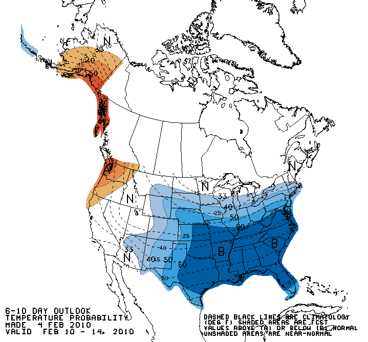
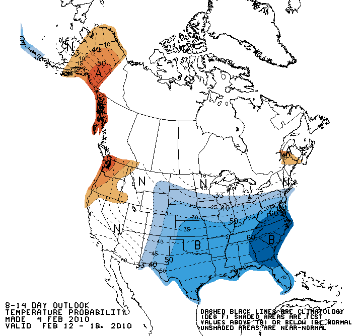
for parts of the eastern 2/3rd of the country.
0 likes   
The above post and any post by Ntxw is NOT an official forecast and should not be used as such. It is just the opinion of the poster and may or may not be backed by sound meteorological data. It is NOT endorsed by any professional institution including Storm2k. For official information, please refer to NWS products.


  Help support Storm2K!

Help Support Storm2K


User avatar
Portastorm
Storm2k Moderator
Storm2k Moderator
Posts: 9914
Age: 63
Joined: Fri Jul 11, 2003 9:16 am
Location: Round Rock, TX
Contact:

Re: Texas winter wx thread (2009-2010)

#5233 Postby Portastorm » Thu Feb 04, 2010 4:30 pm

A couple of interesting snippets from afternoon AFDs out of Fort Worth and Austin/San Antonio NWSFOs:

FORT WORTH
-------------
A REINFORCING SHOT OF COLD AIR WILL ARRIVE AROUND THURSDAY NEXT
WEEK. THIS ARCTIC AIR WILL HAVE ITS ORIGINS NORTH OF 60 WITHIN THE
MAINLAND PORTION OF NUNAVUT. WILL REFRAIN FROM INTRODUCING PRECIP
AT THIS TIME...BUT ANOTHER OPPORTUNITY FOR WINTER WEATHER COULD BE
IN THE OFFING.

AUSTIN/SAN ANTONIO
---------------------
ANOTHER COLD FRONT IS EXPECTED LATE IN THE WEEK. THERE IS A
POSSIBILITY FOR WINTERY PRECIPITATION WITH THIS SECOND SYSTEM.
HOWEVER...HAVE KEPT ONLY COLD RAINS IN THE FORECAST FOR THE TIME
BEING AS IT IS PREMATURE TO ADD FROZEN PRECIP THIS FAR OUT.
NONETHELESS...THIS SYSTEM OBVIOUSLY BEARS WATCHING. STAY TUNED
0 likes   

User avatar
CaptinCrunch
S2K Supporter
S2K Supporter
Posts: 8731
Age: 57
Joined: Mon Nov 03, 2003 4:33 pm
Location: Kennedale, TX (Tarrant Co.)

Re: Texas winter wx thread (2009-2010)

#5234 Postby CaptinCrunch » Thu Feb 04, 2010 5:07 pm

Portastorm wrote:A couple of interesting snippets from afternoon AFDs out of Fort Worth and Austin/San Antonio NWSFOs:

FORT WORTH
-------------
A REINFORCING SHOT OF COLD AIR WILL ARRIVE AROUND THURSDAY NEXT
WEEK. THIS ARCTIC AIR WILL HAVE ITS ORIGINS NORTH OF 60 WITHIN THE
MAINLAND PORTION OF NUNAVUT. WILL REFRAIN FROM INTRODUCING PRECIP
AT THIS TIME...BUT ANOTHER OPPORTUNITY FOR WINTER WEATHER COULD BE
IN THE OFFING.

AUSTIN/SAN ANTONIO
---------------------
ANOTHER COLD FRONT IS EXPECTED LATE IN THE WEEK. THERE IS A
POSSIBILITY FOR WINTERY PRECIPITATION WITH THIS SECOND SYSTEM.
HOWEVER...HAVE KEPT ONLY COLD RAINS IN THE FORECAST FOR THE TIME
BEING AS IT IS PREMATURE TO ADD FROZEN PRECIP THIS FAR OUT.
NONETHELESS...THIS SYSTEM OBVIOUSLY BEARS WATCHING. STAY TUNED


Should of added this in from the NWS FTW AFD

NEXT RAIN EVENT WILL BEGIN SUNDAY. STILL APPEARS SIGNIFICANT
PRECIP WILL END BEFORE TEMPS FALL TO FREEZING MONDAY NIGHT.
HOWEVER...500MB TROUGH LAGS BEHIND LOW-LEVEL COLD ADVECTION...
AND SOME LIGHT WINTRY PRECIP IS NOT OUT OF THE QUESTION LATE
MONDAY NIGHT. WILL MAINTAIN FORECAST WITH RAIN TAPERING OFF FROM
NORTHWEST TO SOUTHEAST.
0 likes   

User avatar
Ntxw
Storm2k Moderator
Storm2k Moderator
Posts: 22790
Joined: Wed Oct 21, 2009 6:34 pm
Location: DFW, Texas

#5235 Postby Ntxw » Thu Feb 04, 2010 5:14 pm

Well the models did show light precip, and I mean very light a flurry if that. Nothing to effect roadways by any means. Now if you travel up to Oklahoma and Kansas that's a whole other story.
0 likes   
The above post and any post by Ntxw is NOT an official forecast and should not be used as such. It is just the opinion of the poster and may or may not be backed by sound meteorological data. It is NOT endorsed by any professional institution including Storm2k. For official information, please refer to NWS products.


  Help support Storm2K!

Help Support Storm2K


msstateguy83

#5236 Postby msstateguy83 » Thu Feb 04, 2010 5:15 pm

18z gfs is coming out :D

its at about 108 hours out now AND WOW look at the temps streaming down south! damn... i think the cold air is coming... of course its still running but so far looking
good...
0 likes   

rhoby13
Tropical Low
Tropical Low
Posts: 31
Joined: Thu Dec 03, 2009 4:02 pm
Location: Austin, TX

Re: Texas winter wx thread (2009-2010)

#5237 Postby rhoby13 » Thu Feb 04, 2010 5:22 pm

Me gusta! :D
0 likes   

User avatar
Ntxw
Storm2k Moderator
Storm2k Moderator
Posts: 22790
Joined: Wed Oct 21, 2009 6:34 pm
Location: DFW, Texas

#5238 Postby Ntxw » Thu Feb 04, 2010 5:26 pm

Given it's 18z GFS, Portastorm's dream storm is back!
0 likes   
The above post and any post by Ntxw is NOT an official forecast and should not be used as such. It is just the opinion of the poster and may or may not be backed by sound meteorological data. It is NOT endorsed by any professional institution including Storm2k. For official information, please refer to NWS products.


  Help support Storm2K!

Help Support Storm2K


User avatar
Portastorm
Storm2k Moderator
Storm2k Moderator
Posts: 9914
Age: 63
Joined: Fri Jul 11, 2003 9:16 am
Location: Round Rock, TX
Contact:

Re:

#5239 Postby Portastorm » Thu Feb 04, 2010 5:31 pm

Ntxw wrote:Given it's 18z GFS, Portastorm's dream storm is back!


Doesn't that just figure?! :wink:

I know. I'm watching the run just like y'all are. Trying to temper my enthusiasm and remember the wise words of Wxman57.
0 likes   

User avatar
TeamPlayersBlue
Category 5
Category 5
Posts: 3445
Joined: Tue Feb 02, 2010 1:44 am
Location: Denver/Applewood, CO

#5240 Postby TeamPlayersBlue » Thu Feb 04, 2010 5:32 pm

its showing significant snow for Houston now....me like
0 likes   
Personal Forecast Disclaimer:
The posts in this forum are NOT official forecast and should not be used as such. They are just the opinion of the poster and may or may not be backed by sound meteorological data. They are NOT endorsed by any professional institution or storm2k.org. For official information, please refer to the NHC and NWS products.


Return to “Winter Weather”

Who is online

Users browsing this forum: No registered users and 4 guests