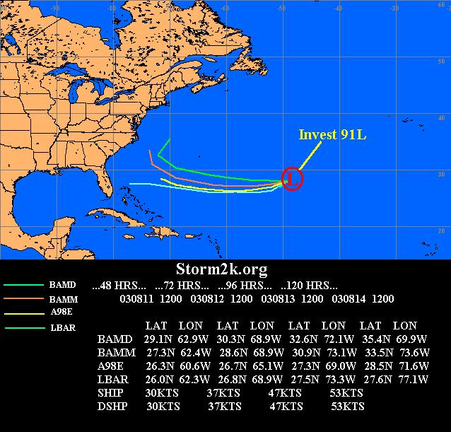
Invest 91L s2k Model map
Moderator: S2k Moderators
Forum rules

The posts in this forum are NOT official forecasts and should not be used as such. They are just the opinion of the poster and may or may not be backed by sound meteorological data. They are NOT endorsed by any professional institution or STORM2K. For official information, please refer to products from the National Hurricane Center and National Weather Service.
-
chadtm80
Invest 91L s2k Model map
I know there are some anxious to see a model map for the new 91L so I figured i would put one together, im sure scott will have his up and going later on..
0 likes
-
hurricanedude

- Military Member

- Posts: 1856
- Joined: Tue Oct 08, 2002 9:54 am
- Location: Virginia Beach, Virginia
- Contact:
-
Anonymous
Global models...
Worth mentioning also is that the global models bring this to the Bahamas area- Could be interresting 
0 likes
-
JetMaxx
Thanks Chad! 
It definitely looks like a threat for some portion of the U.S. coastline by late next week....possibly as a hurricane.
We're almost to the point of the season when major hurricanes become a serious U.S. threat, so this system bears close monitoring by all residents from South Florida to New England.
The earliest in the season major landfall of record for the U.S. Southeast Coast was hurricane Connie on August 12, 1955; South Florida's earliest major landfalling hurricane of record was a ferocious hurricane that struck Miami on August 16-17, 1888.
0 likes
-
chadtm80
-
Scott_inVA

- Storm2k Forecaster

- Posts: 1238
- Joined: Sat Oct 12, 2002 5:44 pm
- Location: Lexington, Virginia
- Contact:
91 MODEL MAP UP
Good job Chad
I'm still drying things out from yesterday but did get the map w/globals up...
http://www.wrel.com/modelmap.htm
Thanks
Scott
I'm still drying things out from yesterday but did get the map w/globals up...
http://www.wrel.com/modelmap.htm
Thanks
Scott
0 likes
-
cycloneye

- Admin

- Posts: 149721
- Age: 69
- Joined: Thu Oct 10, 2002 10:54 am
- Location: San Juan, Puerto Rico
Chad great job as always.
0 likes
Visit the Caribbean-Central America Weather Thread where you can find at first post web cams,radars
and observations from Caribbean basin members Click Here
and observations from Caribbean basin members Click Here
-
ColdFront77
-
vbhoutex

- Storm2k Executive
- Posts: 29150
- Age: 74
- Joined: Wed Oct 09, 2002 11:31 pm
- Location: Cypress, TX
- Contact:
Good job Chad!!! I like both your and Scott's maps because that means I don't have to worry about this one IF it should develop(I can still taste the crow between my teeth from 90l!)!!
There is almost no way that GOMER's could ever be bothered by this one. The E coast trough is dug in so deep I'm not sure it will ever leave the E coast or N FL. We may have a permanent block in place!!! Of course on the other side of this coin is the High pressure ridge we are under that is frying us daily!!! Always trade offs!!!!
There is almost no way that GOMER's could ever be bothered by this one. The E coast trough is dug in so deep I'm not sure it will ever leave the E coast or N FL. We may have a permanent block in place!!!
0 likes
Skywarn, C.E.R.T.
Please click below to donate to STORM2K to help with the expenses of keeping the site going:

Please click below to donate to STORM2K to help with the expenses of keeping the site going:
-
Rainband
-
Scott_inVA
- Storm2k Forecaster
- Posts: 1238
- Joined: Sat Oct 12, 2002 5:44 pm
- Location: Lexington, Virginia
- Contact:
ColdFront77 wrote:In Chad's forecast model map, I see two; not one... basically moving toward Florida.
In the model guidance from our friend, Scott at WREL Radio... a lot more of the models are indicating a movement westward [at least] toward Florida.
Possible it is b/c of different model runs. current page @ WREL is 0Z global/18Z tropicals. I'll get the 12Z globals up shortly
Scott
0 likes
-
Stormsfury

- Category 5

- Posts: 10549
- Age: 53
- Joined: Wed Feb 05, 2003 6:27 pm
- Location: Summerville, SC
-
Scott_inVA
- Storm2k Forecaster
- Posts: 1238
- Joined: Sat Oct 12, 2002 5:44 pm
- Location: Lexington, Virginia
- Contact:
Model Map updated
Stormsfury wrote:I did some maps with the 12z Globals and they are much further south than the tropical models.
Will wait until Scott posts those maps for all to see.
SF
We're getting another round of flooding (again :o ) but jumped on this long enough for a quick update.
http://www.wrel.com/modelmap.htm
Scott
0 likes
-
chadtm80
Who is online
Users browsing this forum: gfsperpendicular and 176 guests