Texas winter wx thread (2009-2010)
Moderator: S2k Moderators
Forum rules
 The posts in this forum are NOT official forecast and should not be used as such. They are just the opinion of the poster and may or may not be backed by sound meteorological data. They are NOT endorsed by any professional institution or STORM2K.

The posts in this forum are NOT official forecast and should not be used as such. They are just the opinion of the poster and may or may not be backed by sound meteorological data. They are NOT endorsed by any professional institution or STORM2K.
-
srainhoutx

- S2K Supporter

- Posts: 6919
- Age: 68
- Joined: Sun Jan 14, 2007 11:34 am
- Location: Haywood County, NC
- Contact:
Re: Texas winter wx thread (2009-2010)
Anyone notice the 1068mb High near Greenland at hour 72 on the 00Z NAM?
0 likes
Carla/Alicia/Jerry(In The Eye)/Michelle/Charley/Ivan/Dennis/Katrina/Rita/Wilma/Ike/Harvey
Member: National Weather Association
Wx Infinity Forums
http://wxinfinity.com/index.php
Facebook.com/WeatherInfinity
Twitter @WeatherInfinity
Member: National Weather Association
Wx Infinity Forums
http://wxinfinity.com/index.php
Facebook.com/WeatherInfinity
Twitter @WeatherInfinity

Re: Texas winter wx thread (2009-2010)
GFS 00z run looks sorta weird to me. I'm not an expert with this stuff, so I guess that's as far as my analysis goes. But it looks off especially after day 6 and beyond.
0 likes

Re: Texas winter wx thread (2009-2010)
iorange55 wrote:GFS 00z run looks sorta weird to me. I'm not an expert with this stuff, so I guess that's as far as my analysis goes. But it looks off especially after day 6 and beyond.
Later in the week, the GFS retrogrades the ridge off the PAC\NW. At the same time a storm hangs around and wants to break down that ridge but doesn't quite do it...looks odd to me too. I think the model is having trouble with that system.
0 likes
The above post and any post by Ntxw is NOT an official forecast and should not be used as such. It is just the opinion of the poster and may or may not be backed by sound meteorological data. It is NOT endorsed by any professional institution including Storm2k. For official information, please refer to NWS products.
Help support Storm2K!
-
Extremeweatherguy

- Category 5

- Posts: 11095
- Joined: Mon Oct 10, 2005 8:13 pm
- Location: Florida

-
vbhoutex

- Storm2k Executive

- Posts: 29143
- Age: 74
- Joined: Wed Oct 09, 2002 11:31 pm
- Location: Cypress, TX
- Contact:
Re:
wxman22 wrote:Hmm so i see im not the only one who thought that it looked a bit strange also its like it has all this cold air sitting in Canada but it doesn't bring it down due to the pattern...
Not by a long shot. It doesn't seem to make sense with the pattern as it is and as it appears to be unfolding based on all the models. Not sure what is going on. Is it having a hard time with the pattern or is it on to something the others haven't picked up on yet? Honestly I think it is the former since it seems to be waffling more than usual from run to run.
0 likes
Skywarn, C.E.R.T.
Please click below to donate to STORM2K to help with the expenses of keeping the site going:

Please click below to donate to STORM2K to help with the expenses of keeping the site going:


Interesting comment from hurricane expert Dr. Jeff Masters in this story about big snow events, wetter and warmer winters and climate change.
It certainly has been much wetter the past 8-10 months or so in the DFW area. If our weather pattern stays wet instead of the droughts of past years then maybe next year will also bring another significant snowfall. This last storm actually brought us too much snow and created some misery with all the power outages and tree damage. But it was beautiful
Jeff Masters: A 2006 study published in the Journal of Applied Meteorology and Climatology found that 61-80% of all heavy snowstorms of 6+ inches in the contiguous U.S. between the years 1900-2001 occurred during winters with above-average temperatures. In other words, the old adage, "it's too cold to snow," has some truth to it. The authors also found that 61-85% of all heavy snowstorms of 6+ inches occurred during winters that were wetter than average. The authors conclude, "a future with wetter and warmer winters ... will bring more heavy snowstorms of 6+ inches than in 1901 - 2000."
It certainly has been much wetter the past 8-10 months or so in the DFW area. If our weather pattern stays wet instead of the droughts of past years then maybe next year will also bring another significant snowfall. This last storm actually brought us too much snow and created some misery with all the power outages and tree damage. But it was beautiful
0 likes
-
srainhoutx
- S2K Supporter
- Posts: 6919
- Age: 68
- Joined: Sun Jan 14, 2007 11:34 am
- Location: Haywood County, NC
- Contact:
Re: Texas winter wx thread (2009-2010)
Appears to be a lot of uncertainty via the HPC Morning Prelim Discussion on just how things will play out this week...but the ECMWF and it's ensemble members are the choice for now...
PRELIMINARY EXTENDED FORECAST DISCUSSION
NWS HYDROMETEOROLOGICAL PREDICTION CENTER CAMP SPRINGS MD
818 AM EST MON FEB 15 2010
VALID 12Z FRI FEB 19 2010 - 12Z MON FEB 22 2010
GLOBAL MODELS AND ENSEMBLES SHOW FAIRLY GOOD AGREEMENT WITH THE
EXPECTED LARGE SCALE MEAN FLOW THRU THE PERIOD BUT THERE ARE SOME
SIGNIFICANT DETAIL ISSUES THAT WILL LIKELY TAKE A WHILE TO BE
RESOLVED. MEANS SHOW TWO PROMINENT CORES OF POSITIVE HGT
ANOMALIES... ONE NEAR THE DAVIS STRAIT AND ANOTHER CLOSE TO THE
ALASKA PANHANDLE. A MODERATE NEG ANOMALY CENTER SHOULD EVOLVE OFF
THE WEST COAST WHILE THE MAJORITY OF THE CONUS SHOULD BE UNDER NEG
HGT ANOMALIES AS WELL. THIS ANOMALY PATTERN IS ASSOC WITH REX
BLOCK TYPE CONFIGURATIONS COVERING THE CANADIAN
MARITIMES/GREENLAND REGION AND ERN PAC/NWRN NOAM. ALSO
UNDERCUTTING PAC FLOW IS FCST TO REACH THE WRN CONUS BY FRI-SAT.
HIGHEST UNCERTAINTY THIS FCST PERIOD INVOLVES THE EVOLUTION OF SRN
CANADA/NWRN CONUS ENERGY AS AN UPR HIGH CLOSES OFF NEAR OR JUST E
OF THE AK PANHANDLE... AND POSSIBLE INTERACTION WITH ERN PAC
ENERGY. LATEST ECMWF/GFS RUNS GENERALLY INDICATE MORE SRN
CANADA/NWRN CONUS ENERGY MAY RETROGRADE COMPARED THE 00Z UKMET/CMC
AND ENSEMBLE MEANS. LACK OF A WELL DEFINED CONSENSUS FAVORS A
BLEND AMONG THE RANGE OF CURRENT SOLNS. BY LATE IN THE PERIOD THE
00Z GFS BECOMES A NRN OUTLIER WITH ITS UPR LOW OFF THE WEST COAST
BY DAY 7 MON WITH THE 06Z GFS COMPARING MUCH BETTER TO
MODEL/ENSEMBLE CONSENSUS. HOWEVER TO DIFFERING DEGREES BOTH THE
00Z AND 06Z GFS RUNS BRING MORE RIDGING INTO THE ROCKIES/HIGH
PLAINS THAN MOST OTHER GUIDANCE. THE CONSENSUS APPEARS MORE
REASONABLE BASED ON TELECONNECTIONS RELATIVE TO AK PANHANDLE/DAVIS
STRAIT RIDGING... WHICH COMBINED WOULD FAVOR MODERATE TROFFING
FROM SRN CANADA AND NRN ROCKIES/PLAINS INTO THE ERN CONUS.
THERE IS FAIR CLUSTERING OF SOLNS WITH AN ERN PAC SHRTWV FCST TO
REACH THE WEST COAST BY DAY 5 SAT WITH 00Z/06Z GFS RUNS HOLDING
THIS ENERGY FARTHER NWWD AT THAT TIME COMPARED TO OTHER MODELS AND
ENSEMBLE MEANS. EWD MOTION OF THIS PROGRESSIVE SYSTEM SHOULD
BRING A WAVE INTO THE ERN CONUS BY DAY 7 MON. THE 00Z ECMWF SEEMS
TO OFFER AN ACCEPTABLE COMPROMISE TRACK IN LIGHT OF POOR ENSEMBLE
CLUSTERING AND UNCERTAINTY OVER THE EXACT ORIENTATION OF NRN
STREAM FLOW WHICH WILL HAVE SOME INFLUENCE ON SYSTEM EVOLUTION.
EARLIER IN THE FCST ANOTHER FEATURE OF NOTE IS A COMPACT
SHRTWV/UPR LOW FCST TO BE OVER ONTARIO/UPR GRTLKS AS OF DAY 3 THU.
OPERATIONAL MODELS DIVERGE CONSIDERABLY WITH TIMING/TRACK ALREADY
BY DAY 4 FRI. THE 00Z ECMWF IS WITHIN THE BROAD SOLN SPREAD...
BETWEEN THE FAST/NWD 06Z GFS AND SLOW 00Z GFS. THE UKMET/CMC ARE
FASTER THAN OTHER MODELS. HOPEFULLY 12Z GUIDANCE DEVELOPS SOME
IMPROVED CLUSTERING WITH THIS FEATURE.
THE UPDATED PRELIM FCST USES A BLEND INCORPORATING HALF WEIGHTING
OF THE 00Z ECMWF WITH THE REMAINDER CONSISTING OF THE 00Z
GEFS/ECMWF ENSEMBLE MEANS... AS THE 00Z ECMWF COMPARES BETTER TO
ENSEMBLES AND TELECONNECTIONS THAN SOME ASPECTS OF LATEST GFS RUNS
AND ENOUGH UNCERTAINTY EXISTS THRU THE PERIOD TO SMOOTH OUT SOME
OPERATIONAL MODEL DETAILS.
RAUSCH
0 likes
Carla/Alicia/Jerry(In The Eye)/Michelle/Charley/Ivan/Dennis/Katrina/Rita/Wilma/Ike/Harvey
Member: National Weather Association
Wx Infinity Forums
http://wxinfinity.com/index.php
Facebook.com/WeatherInfinity
Twitter @WeatherInfinity
Member: National Weather Association
Wx Infinity Forums
http://wxinfinity.com/index.php
Facebook.com/WeatherInfinity
Twitter @WeatherInfinity
-
msstateguy83
the end of this wk could be something big imo, its just gonna take time with the models getting a clearer picture
b/c one thing is pretty clear attm they are not handling this wx pattern well at all. but there will still be plenty
more winter iam sure, likely with the pattern we are in atleast 1 more big winter storm event.
b/c one thing is pretty clear attm they are not handling this wx pattern well at all. but there will still be plenty
more winter iam sure, likely with the pattern we are in atleast 1 more big winter storm event.
0 likes


Re:
funster wrote:Interesting comment from hurricane expert Dr. Jeff Masters in this story about big snow events, wetter and warmer winters and climate change.Jeff Masters: A 2006 study published in the Journal of Applied Meteorology and Climatology found that 61-80% of all heavy snowstorms of 6+ inches in the contiguous U.S. between the years 1900-2001 occurred during winters with above-average temperatures. In other words, the old adage, "it's too cold to snow," has some truth to it. The authors also found that 61-85% of all heavy snowstorms of 6+ inches occurred during winters that were wetter than average. The authors conclude, "a future with wetter and warmer winters ... will bring more heavy snowstorms of 6+ inches than in 1901 - 2000."
It certainly has been much wetter the past 8-10 months or so in the DFW area. If our weather pattern stays wet instead of the droughts of past years then maybe next year will also bring another significant snowfall. This last storm actually brought us too much snow and created some misery with all the power outages and tree damage. But it was beautiful
This winter has been below normal for most of the East/Southeast and the South.
0 likes
“If you thought that science was certain - well, that is just an error on your part.”
-
Portastorm

- Storm2k Moderator

- Posts: 9954
- Age: 63
- Joined: Fri Jul 11, 2003 9:16 am
- Location: Round Rock, TX
- Contact:
Re: Texas winter wx thread (2009-2010)
If the Pacific system undercuts and disrupts the West Coast ridging into Alaska ... you can forget about your winter storm for Texas next weekend. That's the key, IMHO. Those of us cheering on more "winter" need to watch that closely.
0 likes
-
srainhoutx
- S2K Supporter
- Posts: 6919
- Age: 68
- Joined: Sun Jan 14, 2007 11:34 am
- Location: Haywood County, NC
- Contact:
Re: Texas winter wx thread (2009-2010)
The difference between the EC and the GFS (500mb) in the 8-10 range...

0 likes
Carla/Alicia/Jerry(In The Eye)/Michelle/Charley/Ivan/Dennis/Katrina/Rita/Wilma/Ike/Harvey
Member: National Weather Association
Wx Infinity Forums
http://wxinfinity.com/index.php
Facebook.com/WeatherInfinity
Twitter @WeatherInfinity
Member: National Weather Association
Wx Infinity Forums
http://wxinfinity.com/index.php
Facebook.com/WeatherInfinity
Twitter @WeatherInfinity
-
Portastorm
- Storm2k Moderator
- Posts: 9954
- Age: 63
- Joined: Fri Jul 11, 2003 9:16 am
- Location: Round Rock, TX
- Contact:
Re: Texas winter wx thread (2009-2010)
Didn't see anyone post this yet so I thought I would ... link below to Larry Cosgrove's latest blog entry. He's basically saying look for a major Arctic outbreak in the next 10 days which could set some new record lows in Texas. He's also bullish on one more winter storm. After about Feb. 25th though ... seems like he's suggesting the pattern relaxes and winter may be over (or at least return to normal climatological values).
The link:
http://www.examiner.com/x-3775-Houston-Weather-Examiner~y2010m2d14-WEATHERAmerica-Newsletter-Sunday-February-14-2010-at-600-PM-CT
The link:
http://www.examiner.com/x-3775-Houston-Weather-Examiner~y2010m2d14-WEATHERAmerica-Newsletter-Sunday-February-14-2010-at-600-PM-CT
0 likes
-
srainhoutx
- S2K Supporter
- Posts: 6919
- Age: 68
- Joined: Sun Jan 14, 2007 11:34 am
- Location: Haywood County, NC
- Contact:
Re: Texas winter wx thread (2009-2010)
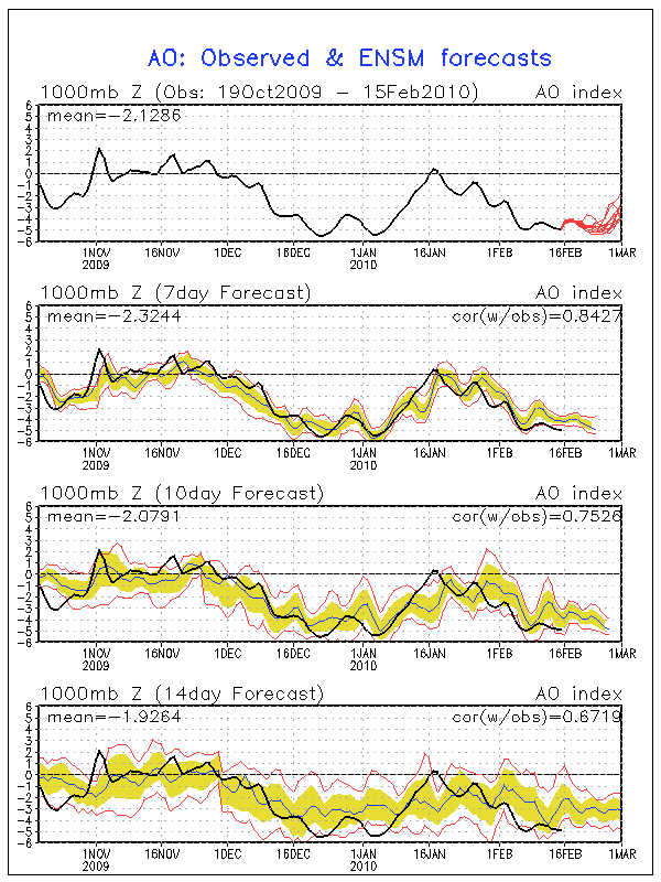
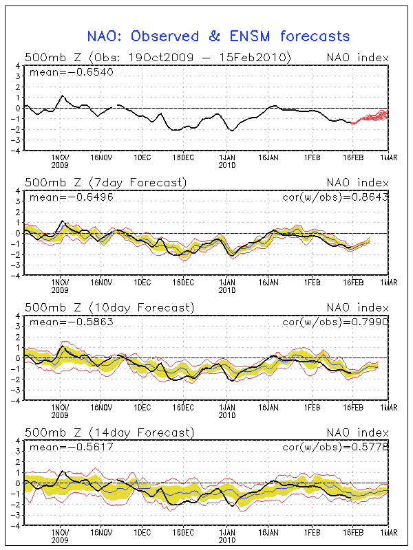
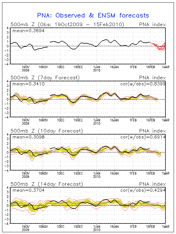
LC forecast are some what correct and in line with what donsutherland1 has stated regarding a relaxing of the blocking pattern. With that said, AO as well as NAO are still very negative. Also, while the GFS ensembles suggested yesterday that the PNA would begin it's fall to neutral, it still continues to climb slowly and remain positive... 
0 likes
Carla/Alicia/Jerry(In The Eye)/Michelle/Charley/Ivan/Dennis/Katrina/Rita/Wilma/Ike/Harvey
Member: National Weather Association
Wx Infinity Forums
http://wxinfinity.com/index.php
Facebook.com/WeatherInfinity
Twitter @WeatherInfinity
Member: National Weather Association
Wx Infinity Forums
http://wxinfinity.com/index.php
Facebook.com/WeatherInfinity
Twitter @WeatherInfinity
Re: Texas winter wx thread (2009-2010)
Yea looks that the PNA wants to come back.
0 likes
“If you thought that science was certain - well, that is just an error on your part.”
-
Portastorm
- Storm2k Moderator
- Posts: 9954
- Age: 63
- Joined: Fri Jul 11, 2003 9:16 am
- Location: Round Rock, TX
- Contact:
Re: Texas winter wx thread (2009-2010)
Looking over the 12z GFS ... thru 90 hrs ... encouraging. West Coast ridge stronger and high pressure coming down through the Rockies.
Edit update: thru 108 hrs, still encouraging. 850mb 0-degree isotherm cutting across Tx pandhandle. In the 0z run, it was up in Kansas.
Edit update: thru 108 hrs, still encouraging. 850mb 0-degree isotherm cutting across Tx pandhandle. In the 0z run, it was up in Kansas.
0 likes
Re: Texas winter wx thread (2009-2010)
This run is in the right direction, but hopefully it's still wrong.
0 likes
-
Portastorm
- Storm2k Moderator
- Posts: 9954
- Age: 63
- Joined: Fri Jul 11, 2003 9:16 am
- Location: Round Rock, TX
- Contact:
Re: Texas winter wx thread (2009-2010)
iorange55 wrote:This run is in the right direction, but hopefully it's still wrong.
Yeah, the cold air never really sinks further south than the Panhandle. The run is through 150 hours now and looks very ugly. Well, maybe we can take solace in the trends in the early part of the run and wait to see what the Euro and CMC show us at lunchtime! (Portastorm trying to be encouraging)
0 likes
-
orangeblood
- S2K Supporter
- Posts: 3895
- Joined: Tue Dec 15, 2009 6:14 pm
- Location: Fort Worth, TX
Re: Texas winter wx thread (2009-2010)
The next big storm in Texas, if there is one, doesn't look like it will be this week. I think the GFS is showing us hints every other run it seems with the potential big winter storm occuring around the 24th-25th. This appears to be the best opportunity for the next BIG one to occur.
0 likes

Who is online
Users browsing this forum: No registered users and 149 guests