Texas winter wx thread (2009-2010)

Winter Weather Discussion

Moderator: S2k Moderators

Forum rules

The posts in this forum are NOT official forecast and should not be used as such. They are just the opinion of the poster and may or may not be backed by sound meteorological data. They are NOT endorsed by any professional institution or STORM2K.

Help Support Storm2K
Message
Author
User avatar
iorange55
Category 5
Category 5
Posts: 2388
Joined: Thu Nov 13, 2008 9:47 pm
Location: Big D

Re:

#7861 Postby iorange55 » Sat Feb 20, 2010 12:19 am

txtiff wrote:Okay so I have about 10 snowballs in my freezer (left over from last weeks storm) that my son has saved. Do you guys think it would be safe to convince him to throw them out and make room for the next batch?? :lol:


Lol, I wouldn't risk it till it's falling. You know the weather here.
0 likes   

WacoWx
Category 2
Category 2
Posts: 664
Joined: Mon Dec 28, 2009 4:14 pm
Location: NOT Waco, TX ----> Dallas, TX

Re: Texas winter wx thread (2009-2010)

#7862 Postby WacoWx » Sat Feb 20, 2010 12:21 am

txwxwatcher wrote:
Storm Tracker SA-CS wrote:what do you guys think for the college station area snowfall totals?


Though others may want to make predictions, I personally would hold back from guessing on specific snowfall totals at this point (especially considering the well-publicized bust for the Dallas area last go-round). That being said, the trends have been looking good for your area, and if they continue, I would be surprised if you did not see accumulating snow.


As someone who bases all of their meteorological decisions on this boards opinions and analysis, ^^this is said perfectly. Also, as someone who is 90-100 miles NW of you, i pray to jeebus that you get accumulating snow. Your excitement and anticipation is justified...and matched by 99% here. Being on the edge of the wrong sidise of the fun is NO FUN. i'm drunk on a weather board on a saturday. its an addiction. the wether that is. that took me 23 minutes to type

hook 'em
:flag:
0 likes   

User avatar
Ntxw
Storm2k Moderator
Storm2k Moderator
Posts: 22790
Joined: Wed Oct 21, 2009 6:34 pm
Location: DFW, Texas

Re: Texas winter wx thread (2009-2010)

#7863 Postby Ntxw » Sat Feb 20, 2010 12:22 am

txwxwatcher wrote:
Storm Tracker SA-CS wrote:what do you guys think for the college station area snowfall totals?


Though others may want to make predictions, I personally would hold back from guessing on specific snowfall totals at this point (especially considering the well-publicized bust for the Dallas area last go-round). That being said, the trends have been looking good for your area, and if they continue, I would be surprised if you did not see accumulating snow.


That's quite a bold statement for that far south. Remember what Wxman said, the precip shown depicts the amount 6 hours prior which doesn't have very much precip after cold enough air arrives. GFS doesn't have much in the way of accumulating snow for the Houston area via 0z or CLL (a dusting to an inch), however it is a good run if you like trends. I hope you get all the snow you're wanting =D

Freezing line is marching into HGX with the amount already fallen, not freezing yet.
Image

Not much left and the freezing line is making it's way off the coast.
Image
Last edited by Ntxw on Sat Feb 20, 2010 12:29 am, edited 1 time in total.
0 likes   
The above post and any post by Ntxw is NOT an official forecast and should not be used as such. It is just the opinion of the poster and may or may not be backed by sound meteorological data. It is NOT endorsed by any professional institution including Storm2k. For official information, please refer to NWS products.

  Help support Storm2K!
Help Support Storm2K

User avatar
txtiff
Tropical Storm
Tropical Storm
Posts: 114
Joined: Thu Dec 24, 2009 2:27 am
Location: Kaufman, Texas

Re: Re:

#7864 Postby txtiff » Sat Feb 20, 2010 12:25 am

iorange55 wrote:
txtiff wrote:Okay so I have about 10 snowballs in my freezer (left over from last weeks storm) that my son has saved. Do you guys think it would be safe to convince him to throw them out and make room for the next batch?? :lol:


Lol, I wouldn't risk it till it's falling. You know the weather here.


I know, I know......lol :froze:
0 likes   

User avatar
wxgirl69
Tropical Storm
Tropical Storm
Posts: 120
Age: 55
Joined: Wed Nov 18, 2009 9:32 pm
Location: Deer Park, Texas

Re: Texas winter wx thread (2009-2010)

#7865 Postby wxgirl69 » Sat Feb 20, 2010 12:28 am

txwxwatcher wrote:Folks in SE Texas, particularly in the Houston area, should be happy with this latest GFS run. The model appears to show the precip lingering around a while for them with temperatures low enough to support snow.


I think I will wait for the Sunday model runs before I predict snow for Houston.. I am the first one to jump up and down for snow.. But, way to early toooo get excited....
0 likes   

Storm Tracker SA-CS
Tropical Depression
Tropical Depression
Posts: 97
Joined: Fri Feb 19, 2010 2:01 pm
Location: College Station, TX

Re: Texas winter wx thread (2009-2010)

#7866 Postby Storm Tracker SA-CS » Sat Feb 20, 2010 12:45 am

ahhh i really would love 1-2 inches here. what do you guys think the chance of that happening is? 20%? 30%?
0 likes   

msstateguy83

Re: Texas winter wx thread (2009-2010)

#7867 Postby msstateguy83 » Sat Feb 20, 2010 12:52 am

iam sticking to my guns the graphic tells the story i dont buy the far southern track of this system
we will see who is right in the end but widespread 6" amts possible in the blue shaded area with higher
amounts just nw of the metroplex region..OK also needs to watch out for this system i see snow totals
poss maxing out somewhere near the redriver w possibly even some significant snow into sc, swrn ok...

as of course with any forecast it is subject to change so stay tuned and as we get more data in over
the weekend we should get a better handle on it...if the models dont change by 00z sunday or
early monday i might change my mind but until then i strongly feel IT WILL NOT LAY DOWN THAT MUCH
SNOW THAT FAR SOUTH but we will see :wink: iam by no means trying to be the scrooge on this just
my strong opinion on the matter..... more thoughts later in the weekend


URL=http://img28.imageshack.us/i/snow22.jpg/]Image[/URL]

The following post is NOT an official forecast and should not be used as such. It is just the opinion of the poster and may or may not be backed by sound meteorological data. It is NOT endorsed by any professional institution including storm2k.org. For official information, please refer to NWS products.
0 likes   

User avatar
Ntxw
Storm2k Moderator
Storm2k Moderator
Posts: 22790
Joined: Wed Oct 21, 2009 6:34 pm
Location: DFW, Texas

Re: Texas winter wx thread (2009-2010)

#7868 Postby Ntxw » Sat Feb 20, 2010 12:58 am

FWIW GFS hasn't shifted much from last night.

0z
Image
0 likes   
The above post and any post by Ntxw is NOT an official forecast and should not be used as such. It is just the opinion of the poster and may or may not be backed by sound meteorological data. It is NOT endorsed by any professional institution including Storm2k. For official information, please refer to NWS products.


  Help support Storm2K!

Help Support Storm2K


Peanut432
Tropical Storm
Tropical Storm
Posts: 119
Joined: Mon Jan 25, 2010 10:21 pm
Location: Hollis Ok

Re: Texas winter wx thread (2009-2010)

#7869 Postby Peanut432 » Sat Feb 20, 2010 1:06 am

msstateguy83 wrote:iam sticking to my guns the graphic tells the story i dont buy the far southern track of this system
we will see who is right in the end but widespread 6" amts possible in the blue shaded area with higher
amounts just nw of the metroplex region..OK also needs to watch out for this system i see snow totals
poss maxing out somewhere near the redriver w possibly even some significant snow into sc, swrn ok...

as of course with any forecast it is subject to change so stay tuned and as we get more data in over
the weekend we should get a better handle on it...if the models dont change by 00z sunday or
early monday i might change my mind but until then i strongly feel IT WILL NOT LAY DOWN THAT MUCH
SNOW THAT FAR SOUTH but we will see :wink: iam by no means trying to be the scrooge on this just
my strong opinion on the matter..... more thoughts later in the weekend


URL=http://img28.imageshack.us/i/snow22.jpg/]Image[/URL]

The following post is NOT an official forecast and should not be used as such. It is just the opinion of the poster and may or may not be backed by sound meteorological data. It is NOT endorsed by any professional institution including storm2k.org. For official information, please refer to NWS products.

What makes you think the storm will go north? It has been pretty insistent in takeing the heaviest snow into central Texas.
0 likes   

User avatar
Extremeweatherguy
Category 5
Category 5
Posts: 11095
Joined: Mon Oct 10, 2005 8:13 pm
Location: Florida

#7870 Postby Extremeweatherguy » Sat Feb 20, 2010 1:09 am

0 likes   

User avatar
Extremeweatherguy
Category 5
Category 5
Posts: 11095
Joined: Mon Oct 10, 2005 8:13 pm
Location: Florida

#7871 Postby Extremeweatherguy » Sat Feb 20, 2010 1:17 am

The 00z ECMWF is starting to come in..

Here is a look at what it is showing at 72 hours out (00z Tuesday):
850mb temps: http://i43.photobucket.com/albums/e371/ ... l_f072.gif
500mb map: http://i43.photobucket.com/albums/e371/ ... d_f072.gif
700mb RH: http://i43.photobucket.com/albums/e371/ ... m_f072.gif
850mb RH: http://i43.photobucket.com/albums/e371/ ... m_f072.gif

And at 96 hours out (00z Wednesday):
850mb temps: http://i43.photobucket.com/albums/e371/ ... l_f096.gif
500mb map: http://i43.photobucket.com/albums/e371/ ... d_f096.gif
700mb RH: http://i43.photobucket.com/albums/e371/ ... m_f096.gif
850mb RH: http://i43.photobucket.com/albums/e371/ ... m_f096.gif

It looks like the ECMWF wants to target the northern areas (north of I-20 in Texas up into Oklahoma) on Monday into early Tuesday, and then the southern areas (I-20 southward in Texas) Tuesday into early Wednesday.
Last edited by Extremeweatherguy on Sat Feb 20, 2010 1:29 am, edited 2 times in total.
0 likes   

User avatar
Ntxw
Storm2k Moderator
Storm2k Moderator
Posts: 22790
Joined: Wed Oct 21, 2009 6:34 pm
Location: DFW, Texas

#7872 Postby Ntxw » Sat Feb 20, 2010 1:21 am

Either way, either side of DFW is going to get pretty good snows (looks like 100 miles or so has the best chance in range). Question is how far south this will get to give some people who haven't experienced snow this winter a last hurrah. My only issue with the far northern track is the PV and the storm beforehand already shifting the boundary south (not quite as south as central Texas for the axis in my belief).

I think the best thing to do right now for forecasting is to take a blend of bunch. We won't know for sure sure until pretty much when the precip shield develops.
Last edited by Ntxw on Sat Feb 20, 2010 1:37 am, edited 1 time in total.
0 likes   
The above post and any post by Ntxw is NOT an official forecast and should not be used as such. It is just the opinion of the poster and may or may not be backed by sound meteorological data. It is NOT endorsed by any professional institution including Storm2k. For official information, please refer to NWS products.


  Help support Storm2K!

Help Support Storm2K


Storm Tracker SA-CS
Tropical Depression
Tropical Depression
Posts: 97
Joined: Fri Feb 19, 2010 2:01 pm
Location: College Station, TX

Re: Texas winter wx thread (2009-2010)

#7873 Postby Storm Tracker SA-CS » Sat Feb 20, 2010 1:30 am

how much snow for cs based on the new ecmwf?
0 likes   

User avatar
Ntxw
Storm2k Moderator
Storm2k Moderator
Posts: 22790
Joined: Wed Oct 21, 2009 6:34 pm
Location: DFW, Texas

Re: Texas winter wx thread (2009-2010)

#7874 Postby Ntxw » Sat Feb 20, 2010 1:43 am

Storm Tracker SA-CS wrote:how much snow for cs based on the new ecmwf?


Can't really tell via ECMWF. You'd have to ask a pro met with access as the free site doesn't really give precip amounts.
0 likes   
The above post and any post by Ntxw is NOT an official forecast and should not be used as such. It is just the opinion of the poster and may or may not be backed by sound meteorological data. It is NOT endorsed by any professional institution including Storm2k. For official information, please refer to NWS products.


  Help support Storm2K!

Help Support Storm2K


Storm Tracker SA-CS
Tropical Depression
Tropical Depression
Posts: 97
Joined: Fri Feb 19, 2010 2:01 pm
Location: College Station, TX

Re: Texas winter wx thread (2009-2010)

#7875 Postby Storm Tracker SA-CS » Sat Feb 20, 2010 1:44 am

well is it supporting the gfs again?
0 likes   

User avatar
Ntxw
Storm2k Moderator
Storm2k Moderator
Posts: 22790
Joined: Wed Oct 21, 2009 6:34 pm
Location: DFW, Texas

Re: Texas winter wx thread (2009-2010)

#7876 Postby Ntxw » Sat Feb 20, 2010 1:46 am

Storm Tracker SA-CS wrote:well is it supporting the gfs again?


They aren't too different in set up.
0 likes   
The above post and any post by Ntxw is NOT an official forecast and should not be used as such. It is just the opinion of the poster and may or may not be backed by sound meteorological data. It is NOT endorsed by any professional institution including Storm2k. For official information, please refer to NWS products.


  Help support Storm2K!

Help Support Storm2K


Snowman67
Category 2
Category 2
Posts: 633
Joined: Thu Dec 31, 2009 12:44 pm
Location: Tomball, TX

Re: Texas winter wx thread (2009-2010)

#7877 Postby Snowman67 » Sat Feb 20, 2010 7:42 am

From this morning's Houston/Galveston area forecast discussion:

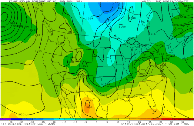
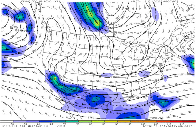
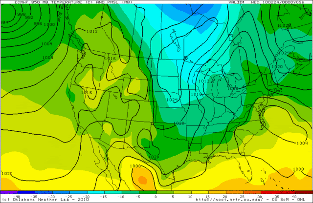
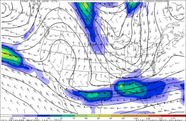
LONG RANGE...MODELS ARE IN BETTER AGREEMENT THAT A STRONG UPPER
LEVEL DISTURBANCE WILL APPROACH SOUTHEAST TEXAS ON TUESDAY
AFTERNOON. MODELS ARE TRENDING A TOUCH NORTH WITH THE BETTER
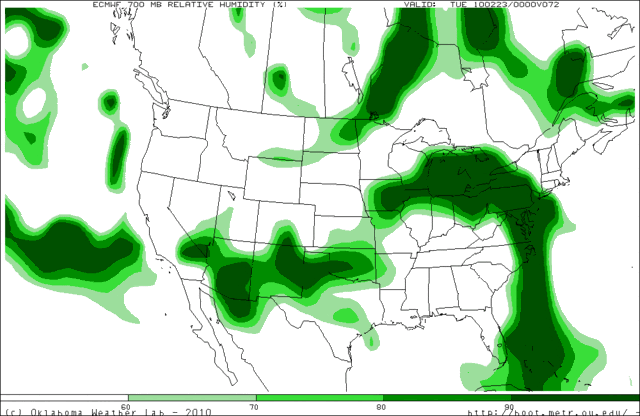
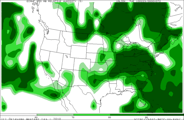
MOISTURE BUT PARAMETERS ARE STILL COMING TOGETHER FOR LIGHT
RAIN...MIXING WITH OR CHANGING TO SNOW OVER THE NORTHERN THIRD OF
THE REGION. FURTHER SOUTH...RAIN COULD STILL MIX WITH A LITTLE
SNOW AS FAR SOUTH AS HOUSTON TUESDAY NIGHT. STILL A FEW DAYS AWAY
AND MUCH CAN CHANGE BETWEEN NOW AND TUESDAY. CONFIDENCE IS A BIT
HIGHER TODAY AS THE CANADIAN AND ECMWF ARE ON BOARD WITH THE
PRECIPITATION. DIFFERENCES ABOUND WITH REGARD TO THE THERMAL
PROFILE. THE GFS IS STILL THE COLDEST MODEL WITH THE ECMWF AND
CANADIAN INDICATING RAIN WITH BOTH MODELS TRENDING COLDER. THE GFS HAS
BEEN SHOWING SNOW OVER THE NORTHERN ZONES FOR SIX CONSECUTIVE
MODEL RUNS.
SOME CLEARING EXPECTED BEHIND TUESDAYS SYSTEM WITH DRY
WEATHER AND COOL TEMPERATURES PREVAILING WEDNESDAY THROUGH FRIDAY.
ANOTHER STRONG SYSTEM WILL APPROACH SOUTHEAST TEXAS NEXT WEEKEND
WITH RAIN CHANCES AGAIN IN THE FORECAST.

We in SE Texas shouldn't give up hope just yet :wink:
0 likes   
Any forecast I make is based on my opinion only. Please refer to the NWS or NHC for official forecasts.

User avatar
DentonGal
Tropical Storm
Tropical Storm
Posts: 189
Joined: Sun Dec 27, 2009 6:25 am
Location: Denton, TX

#7878 Postby DentonGal » Sat Feb 20, 2010 8:06 am

Here's the thoughts out of FW this morning.

AREA FORECAST DISCUSSION
NATIONAL WEATHER SERVICE FORT WORTH TX
505 AM CST SAT FEB 20 2010

.AVIATION...
EXPECT IFR CEILINGS AT ALL TAF SITES THIS MORNING WITH 3-5SM IN
PATCHY DRIZZLE AND FOG. CONDITIONS WILL GRADUALLY IMPROVE THIS
MORNING WITH MVFR CIGS EXPECTED TO PREVAIL BY MIDDAY. WITH
CONTINUED SOUTHERLY FLOW OF 9-13KTS...STRATUS AND MVFR CEILINGS
WILL PERSIST INTO THE OVERNIGHT HOURS. AS LARGE SCALE LIFT
INCREASES LATE TONIGHT AND EARLY SUNDAY MORNING...EXPECT NUMEROUS
SHOWERS AND THUNDERSTORMS TO SPREAD INTO METROPLEX AREA BY 1000Z
(400 AM CST). 09

&&


.PREV DISCUSSION... /ISSUED 432 AM CST SAT FEB 20 2010/
UPPER LEVEL LOW NOW MOVING ONSHORE IN SOUTHERN CALIFORNIA WILL BE
OUR PRIMARY WEATHER MAKER IN THE SHORT-TERM. THIS SYSTEM WILL OPEN
UP AND MOVE RAPIDLY EASTWARD THROUGH THE DESERT SW TODAY AND BE
IN WEST TEXAS BY TONIGHT. MEANWHILE...SOUTHERLY LOW LEVEL FLOW AND
MOISTURE ADVECTION WILL CONTINUE THROUGH THE DAY TODAY WITH
GENERALLY CLOUDY SKIES. LOW LEVEL AIR MASS WILL BE STRONGLY CAPPED
THROUGH THIS EVENING...BUT DO EXPECT SOME LIGHT RAIN OR DRIZZLE TO
BE POSSIBLE IN THE MOIST LAYER BENEATH THE INVERSION.

STRONG UPPER FORCING WILL SPREAD INTO THE REGION DURING THE
OVERNIGHT HOURS...AND RESULT IN LIFTING/SATURATION OF THE MID
LEVELS. EXPECT A BROKEN LINE OF ELEVATED SHOWERS AND STORMS TO
DEVELOP AND MOVE INTO THE WESTERN CWA AFTER MIDNIGHT. CONVECTION
SHOULD ARRIVE IN THE I-35 CORRIDOR JUST BEFORE SUNRISE...AND
CONTINUE TO PUSH EAST DURING THE MORNING HOURS. SOME ELEVATED
INSTABILITY...WITH MUCAPE AOA 500 J/KG...AND DEEP LAYER SHEAR WILL
BE PRESENT. THUS A COUPLE STORMS MAY BE STRONG AND HAVE THE
POTENTIAL TO PRODUCE HAIL OF DIME-NICKEL SIZE. MORNING CONVECTION
SHOULD RAPIDLY MOVE EAST WITH GENERALLY CLEARING SKIES BY LATE
SUNDAY MORNING. A COLD FRONT WILL SLOWLY PUSH SOUTHEAST DURING THE
AFTERNOON AND EVENING HOURS. DAY TIME HEATING AHEAD OF THE FRONT
WILL CREATE AN UNSTABLE/UNCAPPED AIR MASS...BUT SYNOPTIC-SCALE
VERTICAL MOTIONS WILL LARGELY BE SUBSIDENT IN THE WAKE OF THE
MORNING SHORTWAVE. CANT RULE OUT A COUPLE ISOLATED AFTERNOON
STORMS ALONG THE FRONT...BUT WILL SHOW PM POPS AT 20 OR LESS.
NORTHERLY WINDS WILL ALLOW SOME COOLER CANADIAN AIR TO GRADUALLY
INFILTRATE THE REGION SUNDAY NIGHT AND INTO MONDAY.

NEXT FORECAST CONCERN REGARDS SNOW POTENTIAL ON TUESDAY. MODELS
ARE ALL INDICATING THAT SOME PART OF THE CWA WILL EXPERIENCE SNOW
TUESDAY...BUT UNFORTUNATELY THE AGREEMENT ENDS THERE. THE MODELS
ARE IN TWO CAMPS OF THOUGHT...AS THEY CONTINUE TO STRUGGLE WITH
HOW THE BLOCKING HIGH OVER PACIFIC NORTHWEST BREAKS DOWN.

GFS/ECMWF ARE QUICKEST TO BREAK THE HIGH DOWN AND TRANSLATE THE
RIDGE AXIS SOUTHEAST INTO THE ROCKIES BY TUESDAY. THIS MAINTAINS A
SHARP/WELL DEFINED UPPER TROUGH TO ITS EAST...AND SERVES TO DRIVE
MORE COLD AIR ROOSTING OVER THE PLAINS FARTHER SOUTH INTO TEXAS.
THE BEST CHANCES OF SNOW SHOULD THIS 500MB PATTERN VERIFY WOULD
FAVOR AREAS GENERALLY SOUTH OF I-20. THE OTHER SOLUTION OFFERED BY
THE NAM/CANADIAN/SREF TEND TO KEEP THE UPPER HIGH STRONGER...WHICH
KEEPS MORE WEST-EAST FLOW ALOFT ACROSS OUR REGION. THE PRIMARY
UPPER LEVEL VORTICITY PACKET IN THIS PATTERN BECOMES SHEARED APART
AND ELONGATED...COMING ACROSS THE RED RIVER VALLEY ON MONDAY
NIGHT AND TUESDAY MORNING. BEST CHANCES OF SNOW IN THIS REGIME
WOULD THUS FAVOR LOCATIONS GENERALLY NORTH OF I-20...WITH SOUTHERN
LOCATIONS BEING TOO DRY/WARM FOR SNOW.

FOR NOW WE BELIEVE THAT THE GFS/ECMWF FORECASTS ARE MORE RELIABLE.
THIS IS DUE TO GOOD RUN TO RUN CONSISTENCY...INCLUDING AGREEMENT
IN MOST OF THE GFS ENSEMBLE MEMBERS AND EVEN SOME OF THE CANADIAN
ENSEMBLE MEMBERS. IN THE OFFICIAL FORECAST...THE HIGHEST POPS FOR
SNOW WILL BE PLACED ACROSS THE SOUTHERN HALF OF THE CWA TUESDAY
AND TUESDAY EVENING. HOWEVER...WE WILL MAINTAIN AT LEAST A CHANCE
OF SNOW FOR ALL LOCATIONS...UNTIL WE GET A BETTER MODEL CONSENSUS.
IT IS TOO SOON TO SPECULATE ON AMOUNTS OR IMPACTS...BUT WE CAN SAY
THAT THIS SYSTEM WILL HAVE NORTHERLY FLOW IN THE LOW LEVELS AND
THUS NOT HAVE A VIRTUALLY UNLIMITED SUPPLY OF MOISTURE TO WORK
WITH LIKE LAST WEEKS SYSTEM HAD. A SPS WILL BE ISSUED TO HIGHLIGHT
THE LIKELIHOOD THAT SNOW WILL FALL SOMEWHERE IN NORTH TEXAS ON
TUESDAY...AND YET THE UNCERTAINTY THAT STILL EXISTS WITH LOCATION
AND AMOUNTS OR IMPACTS.

THE REMAINDER OF THE FORECAST IS DRY AND UNEVENTFUL. A GRADUAL
WARM UP WILL OCCUR WED THRU FRIDAY.
0 likes   
Mom to 8 really is enough!

User avatar
Portastorm
Storm2k Moderator
Storm2k Moderator
Posts: 9914
Age: 63
Joined: Fri Jul 11, 2003 9:16 am
Location: Round Rock, TX
Contact:

Re: Texas winter wx thread (2009-2010)

#7879 Postby Portastorm » Sat Feb 20, 2010 9:19 am

Here is the latest from Houston pro met Jeff Lindner:

------

Confidence growing in a winter weather event for early next week.

Strong cold front will arrive on Sunday...enjoy the mild temps. this weekend.

Discussion:
Weak return flow underway this morning with a mid level deck over much of the region and fog/mist is some areas. Surface dewpoints have been very slow to recover, and it appears the models are really overdoing the moisture return over the cold nearshore Gulf waters. So far dewpoints have remained below nearshore SST's keeping sea fog as a none issue...this may change during the day on Sunday. Otherwise, colder Gulf waters appear to be mitigating the return of an unstable air mass, and latest model trends support a lower chance for thunderstorms on Sunday as instability will be greatly lacking. Still expect showers late this afternoon through frontal passage, but all severe threat will be removed for Sunday with strong capping in the mid levels and meager amounts of instability.

Early Next Week:

Main forecast item of concern now lies in early next week as strong cold front surges off the coast Monday and then a strong storm system moves across TX in the cold air Tues/Wed. Poor model agreement of late has trended toward each other over the past 24 hours with the ECMWF trending toward the colder and wetter GFS. The GFS continues to lead the pack with the coldest and wettest solution and would indeed produce accumulating snows over parts of SE TX Tuesday afternoon and Tuesday night. The GFS is now supported by the ECMWF, CMC, and several of the ensemble members adding more confidence that some sort of winter weather event will happen early next week.

An extensive review of the 00Z forecast soundings for College Station, Conroe, IAH, and Sugar Land suggest the onset of rainfall around midday Tuesday with soundings all supporting rain. CLL is the coldest, but still above freezing, although the sounding looks like it would support some sleet (IP) or RA/IP mix. By Tuesday evening CLL is fairly close to a saturated and frozen profile with only the lowest levels above freezing. Would expect RA/SN mix changing to all SN Tuesday evening. The other 3 sites remain a touch too warm, but by early Wednesday morning Conroe and IAH show a favorable SN profile....but drying starts to take over by this point.

With all this said, would expect an onset of a winter mix over our N and W counties Tuesday midday with surface temperatures remaining above freezing with no accumulation. RA/SN line will progress southward Tuesday afternoon into the evening hours with all SN over the northern 1/3rd of the area by mid evening Tuesday. Surface temperatures fall closer to freezing in the SN area with some accumulation possible. North of US 59, rain will likely mix with snow late Tuesday evening as the event starts to come to an end.

Too early to lay out any accumulation amounts at this time as deviations in the models could still keep the majority of the frozen precip. north of our area. This event remains low confidence and significant forecast changes over the next 3 days are likely.

As for temperatures Sunday will be the warmest with highs in the 70-75 range and then all downhill from there for all of next week. Will undercut the already cold GFS guidance with highs only in the 40's on Tuesday...possibly 30's up north where clouds/precip. begin first. Could see freezing temps. over parts of the area Tuesday night/Wednesday AM and then possibly more widespread freeze Thursday AM.
0 likes   

User avatar
jasons2k
Storm2k Executive
Storm2k Executive
Posts: 8245
Age: 51
Joined: Wed Jul 06, 2005 12:32 pm
Location: The Woodlands, TX

Re: Texas winter wx thread (2009-2010)

#7880 Postby jasons2k » Sat Feb 20, 2010 9:30 am

Below is the latest from Jeff Lindner.

(Edit: Portastorm beat me to it)

Anyway, given his thoughts the good discussion out of DFW, etc., it does appear the models are getting a better handle on this and are converging towards the more southern solution.

As I've been saying all along -- patience -- it will probably be tomorrow before there is any real confidence in this. But it is looking like those in Central Texas and areas south of the Metroplex may finally get their chance.

Unfortunately for Houston, it looks like a small chance of some snow at the tail end, but that's it.
0 likes   


Return to “Winter Weather”

Who is online

Users browsing this forum: No registered users and 369 guests