Texas winter wx thread (2009-2010)
Moderator: S2k Moderators
Forum rules
 The posts in this forum are NOT official forecast and should not be used as such. They are just the opinion of the poster and may or may not be backed by sound meteorological data. They are NOT endorsed by any professional institution or STORM2K.

The posts in this forum are NOT official forecast and should not be used as such. They are just the opinion of the poster and may or may not be backed by sound meteorological data. They are NOT endorsed by any professional institution or STORM2K.
-
Storm Tracker SA-CS
- Tropical Depression

- Posts: 97
- Joined: Fri Feb 19, 2010 2:01 pm
- Location: College Station, TX

Re: Texas winter wx thread (2009-2010)
Storm Tracker SA-CS wrote:does that signal snow?
First chart is hour 48 when the precip and freezing line is approaching the area, temps aloft aren't cold enough yet (the lines are tightly together meaning the atmosphere is saturated but has warm temps to the right of 0c). Then at hour 54 the lines are moving apart signaling the atmosphere is no longer saturated (precip) as the temps are below freezing aloft (to the left 0c line) for snow. Could be a period in there for some snow, doesn't look like much right now via 0z GFS.
0 likes
The above post and any post by Ntxw is NOT an official forecast and should not be used as such. It is just the opinion of the poster and may or may not be backed by sound meteorological data. It is NOT endorsed by any professional institution including Storm2k. For official information, please refer to NWS products.
Help support Storm2K!
-
Nederlander
- S2K Supporter

- Posts: 1259
- Joined: Sat Jul 19, 2008 4:28 pm
- Location: Conroe, TX
Re: Texas winter wx thread (2009-2010)
Not sure if I'm reading that right but it looks like there's a warm pocket between the 700-850 levels.. That's no good for snow right?
0 likes
0 likes
The above post and any post by Ntxw is NOT an official forecast and should not be used as such. It is just the opinion of the poster and may or may not be backed by sound meteorological data. It is NOT endorsed by any professional institution including Storm2k. For official information, please refer to NWS products.
Help support Storm2K!
Help support Storm2K!
-
southerngale

- Retired Staff

- Posts: 27418
- Joined: Thu Oct 10, 2002 1:27 am
- Location: Southeast Texas (Beaumont area)
Re: Texas winter wx thread (2009-2010)
Great discussion from Houston NWS. Wow.
AREA FORECAST DISCUSSION
NATIONAL WEATHER SERVICE HOUSTON/GALVESTON TX
355 AM CST MON FEB 22 2010
...SIGNIFICANT WINTER WEATHER TO AFFECT THE NORTHERN THIRD OF
SOUTHEAST TEXAS ON TUESDAY AND TUESDAY EVENING...
.DISCUSSION...
DID YOU ENJOY THE 70S TODAY? ENJOY THE CALM BEFORE STORM. A COLD
FRONT HAS CROSSED THE COAST AND HAS CLEARED OUT THE STUBBORN SEA
FOG PLAGUING THE COAST. COLD AIR ADVECTION WILL PERSIST TODAY
THROUGH TUESDAY. WRAP AROUND CLOUDS WILL PERSIST THIS MORNING
BEFORE DISSIPATING AROUND MID DAY LEAVING SKIES PARTLY CLOUDY.
CLOUDS WILL BE ON THE INCREASE LATE TONIGHT AHEAD OF A POTENT
SHORT WAVE THAT WILL APPROACH SOUTHEAST TEXAS ON TUESDAY.
ON TUESDAY AND TUESDAY NIGHT...AS THE S/WV APPROACHES...IT WILL
TAP INTO THE MOISTURE REMAINING OVER THE REGION. COLD AIR
ADVECTION WILL CONTINUE IN THE WAKE OF THIS MORNINGS FRONT. AS
PRECIPITATION BEGINS TO FALL...EVAPORATIVE COOLING OF THE COLUMN
WILL ENSUE. FORECAST SOUNDINGS SHOW A BIT OF DRY AIR AROUND 900 MB
SO ONCE PRECIP BEGINS TO FALL...SO WILL THE TEMPERATURES. ALL MODELS
ARE IN AGREEMENT THAT TEMPERATURES WILL FALL BELOW 0 C NORTH OF A
CALDWELL TO TRINITY LINE BY AFTERNOON. RAIN WILL START IN THE
MORNING BUT QUICKLY CHANGE OVER TO SNOW. A WINTER STORM WATCH HAS
BEEN ISSUED FOR AREAS NORTH OF A BRENHAM TO LIVINGSTON LINE FOR TUESDAY.
HAVE BUMPED POPS UPWARD AREA WIDE FOR TUESDAY AFTERNOON. LOCAL
POLICIES DICTATE THAT A WINTER STORM WATCH IS ISSUED WHEN 2 OR
MORE INCHES OF SNOW IS FORECAST. AT THIS TIME IT APPEARS THAT 2 TO
4 INCHES OF SNOW WILL FALL NORTH OF A BRENHAM TO LIVINGSTON LINE.
THERE ARE MANY UNCERTAINTIES WITH THIS SYSTEM. AM RATHER CONCERNED
THAT CONVECTIVE BANDING COULD SET UP FROM BRYAN TO CROCKETT...
SIMILAR TO WHAT HAPPENED IN DFW A FEW WEEKS AGO. THIS WOULD BUMP
SNOW TOTALS UP SIGNIFICANTLY OVER THE EXTREME NORTH. WHERE DOES
THE RAIN SNOW LINE SET UP? AM CONCERNED THAT MONTGOMERY AND
NORTHWESTERN HARRIS COUNTIES MAY GET ACCUMULATING SNOW LATE
TUESDAY AFTERNOON WHICH IS SOONER THAN MODELS SUGGEST. MODELS
INDICATE THAT TEMPERATURES WILL BE COLD ENOUGH TUESDAY EVENING FOR
THE RAIN TO CHANGE TO SNOW IN HOUSTON AND THERE IS SOME POTENTIAL
FOR MINOR ACCUMULATIONS ON GRASSY SURFACES AS FAR SOUTH AS THE
I-10 CORRIDOR. COULD EVEN GET A RAIN SNOW MIX ALL THE WAY TO THE
COAST. UPPER FLOW QUICKLY BECOMES CONFLUENT BY 09Z WEDNESDAY AND
THE PRECIP SHOULD SHUT DOWN RATHER QUICKLY.
0 likes
Please support Storm2k by making a donation today. It is greatly appreciated! Click here: 
 my Cowboys my Rockets my Astros
my Cowboys my Rockets my Astros

-
srainhoutx

- S2K Supporter
- Posts: 6919
- Age: 68
- Joined: Sun Jan 14, 2007 11:34 am
- Location: Haywood County, NC
- Contact:
Re: Texas winter wx thread (2009-2010)
Good Morning. I see there was a little excitement overnight.  I would not surprised if Advisories/Watches are hoisted into at least Harris County later today. Maybe txagwxman, Portastorm and I may see some snow after all.
Edit to add Tireman4 also as well as everyone in the Houston Metro Area. Further 'refinement' will probably come after the new 12Z data comes out.
Edit to add Tireman4 also as well as everyone in the Houston Metro Area. Further 'refinement' will probably come after the new 12Z data comes out.
0 likes
Carla/Alicia/Jerry(In The Eye)/Michelle/Charley/Ivan/Dennis/Katrina/Rita/Wilma/Ike/Harvey
Member: National Weather Association
Wx Infinity Forums
http://wxinfinity.com/index.php
Facebook.com/WeatherInfinity
Twitter @WeatherInfinity
Member: National Weather Association
Wx Infinity Forums
http://wxinfinity.com/index.php
Facebook.com/WeatherInfinity
Twitter @WeatherInfinity
-
Portastorm

- Storm2k Moderator

- Posts: 9954
- Age: 63
- Joined: Fri Jul 11, 2003 9:16 am
- Location: Round Rock, TX
- Contact:
Re: Texas winter wx thread (2009-2010)
NWSFO Austin/San Antonio has hoisted a Winter Storm Watch for our area for possible 2-4 inches accumulation of snow!!
I guess they're officially "on board" now with the event.
There will be a press conference today at the Portastorm Weather Center following today's 12z model runs.
I guess they're officially "on board" now with the event.
There will be a press conference today at the Portastorm Weather Center following today's 12z model runs.
0 likes
-
Tireman4

- S2K Supporter
- Posts: 5903
- Age: 60
- Joined: Fri Jun 30, 2006 1:08 pm
- Location: Humble, Texas
- Contact:
Re: Texas winter wx thread (2009-2010)
Portastorm wrote:NWSFO Austin/San Antonio has hoisted a Winter Storm Watch for our area for possible 2-4 inches accumulation of snow!!
I guess they're officially "on board" now with the event.
There will be a press conference today at the Portastorm Weather Center following today's 12z model runs.
Cool Porta...will this be broadcast on CNN, Fox, CNBC and others?
0 likes
-
CypressMike

- Tropical Low

- Posts: 41
- Joined: Mon Aug 20, 2007 2:28 pm
- Location: Cypress, TX
- Contact:
Re: Texas winter wx thread (2009-2010)
I hope we finally get some real snow here in NW Harris County. When I moved to Cypress, I thought I'd have a better chance of getting snow that those in the city and southern suburbs. Since I moved here in 2004, exactly the opposite is true. It just isn't fair!!!!!!!!!! 
0 likes
Weather for the Bridgeland community of Cypress, TX
http://bridgelandweather.com/
http://bridgelandweather.com/

Re: Texas winter wx thread (2009-2010)
This mornings NWS HGX discussion is somewhat encouraging for those of us in far NW Harris County:
AM CONCERNED THAT MONTGOMERY AND
NORTHWESTERN HARRIS COUNTIES MAY GET ACCUMULATING SNOW LATE
TUESDAY AFTERNOON WHICH IS SOONER THAN MODELS SUGGEST.
AM CONCERNED THAT MONTGOMERY AND
NORTHWESTERN HARRIS COUNTIES MAY GET ACCUMULATING SNOW LATE
TUESDAY AFTERNOON WHICH IS SOONER THAN MODELS SUGGEST.
0 likes
Any forecast I make is based on my opinion only. Please refer to the NWS or NHC for official forecasts.
-
srainhoutx
- S2K Supporter
- Posts: 6919
- Age: 68
- Joined: Sun Jan 14, 2007 11:34 am
- Location: Haywood County, NC
- Contact:
Re: Texas winter wx thread (2009-2010)
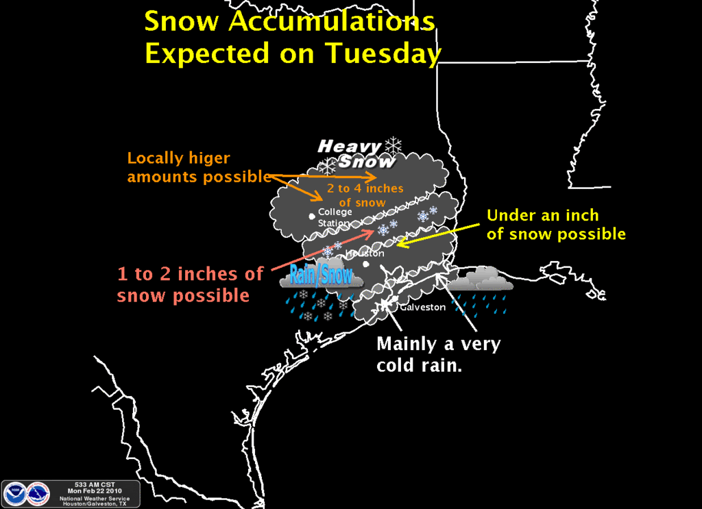
Here is what HGX was thinking this morning...
0 likes
Carla/Alicia/Jerry(In The Eye)/Michelle/Charley/Ivan/Dennis/Katrina/Rita/Wilma/Ike/Harvey
Member: National Weather Association
Wx Infinity Forums
http://wxinfinity.com/index.php
Facebook.com/WeatherInfinity
Twitter @WeatherInfinity
Member: National Weather Association
Wx Infinity Forums
http://wxinfinity.com/index.php
Facebook.com/WeatherInfinity
Twitter @WeatherInfinity


I plotted the hires WRF 4KM...it is colder than the NAM/WRF (00z). It takes College Station to 32F by tomorrow evening.
Maybe we will squeeze 1/4" out of this for Tomball/Spring tomorrow evening (maybe more).
Maybe we will squeeze 1/4" out of this for Tomball/Spring tomorrow evening (maybe more).
Last edited by txagwxman on Mon Feb 22, 2010 9:08 am, edited 1 time in total.
0 likes
“If you thought that science was certain - well, that is just an error on your part.”
Re: Texas winter wx thread (2009-2010)

So you're telling me there's a chance!!!
Last night the Austin area was at the .5 inch mark. This morning we have a winter weather watch and now we're at 2-4 inches. The morning met on KVUE said the northern counties may get upgraded to a warning tomorrow.
0 likes
Re: Texas winter wx thread (2009-2010)
Portastorm wrote:NWSFO Austin/San Antonio has hoisted a Winter Storm Watch for our area for possible 2-4 inches accumulation of snow!!
I guess they're officially "on board" now with the event.
There will be a press conference today at the Portastorm Weather Center following today's 12z model runs.
Where is the party?

0 likes
“If you thought that science was certain - well, that is just an error on your part.”
-
Texas Snowman

- Storm2k Moderator
- Posts: 6197
- Joined: Fri Jan 25, 2008 11:29 am
- Location: Denison, Texas
Re: Texas winter wx thread (2009-2010)
Glad things are trending your way Portastorm and all of the others down south and southeast. Enjoy your snowstorm! 
0 likes
The above post and any post by Texas Snowman is NOT an official forecast and should not be used as such. It is just the opinion of the poster and may or may not be backed by sound meteorological data. It is NOT endorsed by any professional institution including storm2k.org. For official information, please refer to NWS products.

Re: Texas winter wx thread (2009-2010)
CypressMike wrote:I hope we finally get some real snow here in NW Harris County. When I moved to Cypress, I thought I'd have a better chance of getting snow that those in the city and southern suburbs. Since I moved here in 2004, exactly the opposite is true. It just isn't fair!!!!!!!!!!
Hello everyone. I have been a member for awhile but this is my first post. Cypressmike i live South of Houston in the Clear Lake area and when i moved here back in 93 i never thought i would have seen as much snow as i have. I always thought that living north and west of town would be where the better chances for snow would be. The great thing about it is that my kids have enjoyed it. The 2004 event was my first real taste of snow and i was like a kid in a candy store!
0 likes
Re: Texas winter wx thread (2009-2010)
jg5894 wrote:CypressMike wrote:I hope we finally get some real snow here in NW Harris County. When I moved to Cypress, I thought I'd have a better chance of getting snow that those in the city and southern suburbs. Since I moved here in 2004, exactly the opposite is true. It just isn't fair!!!!!!!!!!
Hello everyone. I have been a member for awhile but this is my first post. Cypressmike i live South of Houston in the Clear Lake area and when i moved here back in 93 i never thought i would have seen as much snow as i have. I always thought that living north and west of town would be where the better chances for snow would be. The great thing about it is that my kids have enjoyed it. The 2004 event was my first real taste of snow and i was like a kid in a candy store!
In 1973, it snowed 3x times in Houston...similar El Nino weather pattern (-NAO). We had 1-4" on each snow storm.
0 likes
“If you thought that science was certain - well, that is just an error on your part.”
-
vbhoutex

- Storm2k Executive

- Posts: 29143
- Age: 74
- Joined: Wed Oct 09, 2002 11:31 pm
- Location: Cypress, TX
- Contact:
Re: Texas winter wx thread (2009-2010)
jg5894 wrote:CypressMike wrote:I hope we finally get some real snow here in NW Harris County. When I moved to Cypress, I thought I'd have a better chance of getting snow that those in the city and southern suburbs. Since I moved here in 2004, exactly the opposite is true. It just isn't fair!!!!!!!!!!
Hello everyone. I have been a member for awhile but this is my first post. Cypressmike i live South of Houston in the Clear Lake area and when i moved here back in 93 i never thought i would have seen as much snow as i have. I always thought that living north and west of town would be where the better chances for snow would be. The great thing about it is that my kids have enjoyed it. The 2004 event was my first real taste of snow and i was like a kid in a candy store!
Now you get an "official" welcome from me!
0 likes
Skywarn, C.E.R.T.
Please click below to donate to STORM2K to help with the expenses of keeping the site going:
Please click below to donate to STORM2K to help with the expenses of keeping the site going:
Who is online
Users browsing this forum: No registered users and 85 guests