ENSO Updates (2007 thru 2023)

This is the general tropical discussion area. Anyone can take their shot at predicting a storms path.

Moderator: S2k Moderators

Forum rules

The posts in this forum are NOT official forecasts and should not be used as such. They are just the opinion of the poster and may or may not be backed by sound meteorological data. They are NOT endorsed by any professional institution or STORM2K. For official information, please refer to products from the National Hurricane Center and National Weather Service.

Help Support Storm2K
Message
Author
User avatar
cycloneye
Admin
Admin
Posts: 145299
Age: 68
Joined: Thu Oct 10, 2002 10:54 am
Location: San Juan, Puerto Rico

Re: ENSO Updates=Climate Prediction Center 3/1/10 update

#1121 Postby cycloneye » Mon Mar 01, 2010 2:25 pm

The Australian POAMA model decends to neutral by June.

http://www.bom.gov.au/climate/coupled_model/poama.shtml

Image
0 likes   
Visit the Caribbean-Central America Weather Thread where you can find at first post web cams,radars
and observations from Caribbean basin members Click Here

CrazyC83
Professional-Met
Professional-Met
Posts: 34002
Joined: Tue Mar 07, 2006 11:57 pm
Location: Deep South, for the first time!

#1122 Postby CrazyC83 » Mon Mar 01, 2010 8:34 pm

This sure makes predicting the 2010 hurricane season a nightmare.
0 likes   

User avatar
KWT
Category 5
Category 5
Posts: 31415
Joined: Tue Aug 17, 2004 11:02 am
Location: UK!!!

#1123 Postby KWT » Mon Mar 01, 2010 8:45 pm

I wouldn't be all that surprised if the El nino doesn't weaken quite as fast as some models prog and I'm certainly not seeing any reason to call la nina despite some of the ensembles suggesting its a risk.
0 likes   
Personal Forecast Disclaimer:
The posts in this forum are NOT official forecast and should not be used as such. They are just the opinion of the poster and may or may not be backed by sound meteorological data. They are NOT endorsed by any professional institution or storm2k.org. For official information, please refer to the NHC and NWS products

User avatar
Hurricaneman
Category 5
Category 5
Posts: 7351
Age: 45
Joined: Tue Aug 31, 2004 3:24 pm
Location: central florida

Re: ENSO Updates=Models forecast Neutral by early summer

#1124 Postby Hurricaneman » Tue Mar 02, 2010 1:05 am

I just looked at the subsurface and there seems to be a kelvin wave between 130w and 160w
0 likes   

User avatar
cycloneye
Admin
Admin
Posts: 145299
Age: 68
Joined: Thu Oct 10, 2002 10:54 am
Location: San Juan, Puerto Rico

Re: ENSO Updates=Models forecast Neutral by early summer

#1125 Postby cycloneye » Tue Mar 02, 2010 6:40 am

Hurricaneman wrote:I just looked at the subsurface and there seems to be a kelvin wave between 130w and 160w


This KW may be the last straw of El Nino as the models have a mini spike at this time and then go down to Neutral.

Image
0 likes   
Visit the Caribbean-Central America Weather Thread where you can find at first post web cams,radars
and observations from Caribbean basin members Click Here

User avatar
KWT
Category 5
Category 5
Posts: 31415
Joined: Tue Aug 17, 2004 11:02 am
Location: UK!!!

#1126 Postby KWT » Tue Mar 02, 2010 7:05 am

Yeah, may well also make the El Nino east based as well for a time which may make for a slower start to the season before it fades away.
0 likes   
Personal Forecast Disclaimer:
The posts in this forum are NOT official forecast and should not be used as such. They are just the opinion of the poster and may or may not be backed by sound meteorological data. They are NOT endorsed by any professional institution or storm2k.org. For official information, please refer to the NHC and NWS products

User avatar
cycloneye
Admin
Admin
Posts: 145299
Age: 68
Joined: Thu Oct 10, 2002 10:54 am
Location: San Juan, Puerto Rico

Re: ENSO Updates=Models forecast Neutral by early summer

#1127 Postby cycloneye » Tue Mar 02, 2010 12:08 pm

The CFS model forecasts ENSO to go Neutral by June,but stays that way and not enters La Nina freshold.For those members who may not know when it is Neutral,is between +0.5 to -0.5.

Image

Image
0 likes   
Visit the Caribbean-Central America Weather Thread where you can find at first post web cams,radars
and observations from Caribbean basin members Click Here

User avatar
KWT
Category 5
Category 5
Posts: 31415
Joined: Tue Aug 17, 2004 11:02 am
Location: UK!!!

#1128 Postby KWT » Tue Mar 02, 2010 12:22 pm

Yeah I like the CFS forecast and I think it won't be far short, I also like the way they see a slight rise again this month which makes sense giving the way we are seeing warming at the subsurface level so I'm expecting a slight rise, maybe upto 1.3-1.4C on the weeklies before a drop towards the bottom end of El Nino for May-June, after that slight weakening should continue into the summer to take it IMO just shy of El Nino, at warm Neutral.

Either way odds favour the 3.4 zone being weaker then it was last summer even if El nino hangs on later then expected.
0 likes   
Personal Forecast Disclaimer:
The posts in this forum are NOT official forecast and should not be used as such. They are just the opinion of the poster and may or may not be backed by sound meteorological data. They are NOT endorsed by any professional institution or storm2k.org. For official information, please refer to the NHC and NWS products

User avatar
cycloneye
Admin
Admin
Posts: 145299
Age: 68
Joined: Thu Oct 10, 2002 10:54 am
Location: San Juan, Puerto Rico

Re: ENSO Updates=Models forecast Neutral by early summer

#1129 Postby cycloneye » Tue Mar 02, 2010 5:57 pm

I found these interesting graphics about how many landfalls occur in the three different ENSO phases El Nino (Warm),Neutral and La Nina (Cold) on the east coast of the U.S. and in Florida.

East Coast Landfalls

Image

Florida Landfalls

Image
0 likes   
Visit the Caribbean-Central America Weather Thread where you can find at first post web cams,radars
and observations from Caribbean basin members Click Here

User avatar
ROCK
Category 5
Category 5
Posts: 9484
Age: 54
Joined: Tue Aug 17, 2004 7:30 am
Location: Kemah, Texas

Re: ENSO Updates=Models forecast Neutral by early summer

#1130 Postby ROCK » Tue Mar 02, 2010 7:26 pm

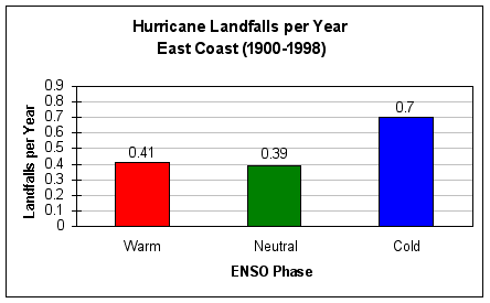
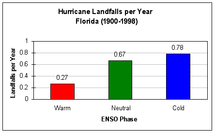
cycloneye wrote:I found these interesting graphics about how many landfalls occur in the three different ENSO phases El Nino (Warm),Neutral and La Nina (Cold) on the east coast of the U.S. and in Florida.

East Coast Landfalls

Image

Florida Landfalls

Image


what about Texas?? you are beginning to sound like JB... :lol:
0 likes   

User avatar
cycloneye
Admin
Admin
Posts: 145299
Age: 68
Joined: Thu Oct 10, 2002 10:54 am
Location: San Juan, Puerto Rico

Re: ENSO Updates=Models forecast Neutral by early summer

#1131 Postby cycloneye » Wed Mar 03, 2010 6:47 am

Australian 3/3/10 update

As expected,a small stall in the decline of El Nino as the models predicted is occuring at this time.Once this period ends,it will be adios to El Nino and hello to Neutral ENSO by late Spring or early Summer.

http://www.bom.gov.au/climate/enso/

Details

The Pacific Ocean sea surface temperature (SST) remains warmer than the long-term average across the central and eastern tropical Pacific. The SST anomaly map for February shows warm anomalies in excess of +1°C covering most of the central equatorial Pacific and parts of teh eastern tropical Pacific. The monthly NINO indices for February were +0.9°C, +1.2°C and +1.0°C for NINO3, NINO3.4 and NINO4 respectively. When compared with January values, both NINO3 and NINO4 have cooled by 0.2°C and NINO3.4 by 0.3°C.

In terms of weekly data, the most recent NINO indices are +0.9°C, +1.2°C and +1.0°C for NINO3, NINO3.4 and NINO4 respectively. When compared with two weeks ago, both NINO3 and NINO4 have warmed slightly by approximately 0.1°C, while NINO3.4 has remained the same in magnitude. The 7-day SST anomaly map shows warm anomalies covering most of the tropical Pacific east of 170³E. When compared with anomalies observed a fortnight ago, there has been little change in the distribution of heat at the sea surface along the equator. An animation of recent SST changes is available.

A four-month sequence of sub-surface Pacific Ocean equatorial temperature anomaly shows a cooling of the sub-surface since the peak in warmth during November. During December and January, weak cool anomalies in the western Pacific propagated eastwards, cooling the sub-surface of the central and eastern Pacific. The western and eastern Pacific continued to cool through February; however the central Pacific has shown some renewed warming. A recent map for the 5 days ending 28 February shows that a large volume of warmer than normal water persists below the surface of the central to eastern tropical Pacific, with anomalies exceeding +4°C in small regions. When compared with two weeks ago, the sub-surface of the equatorial Pacific has cooled slightly in western and central regions and warmed slightly in the eastern Pacific. This recent warming is likely to be a response to a weakening of the trade winds over the western and central Pacific during late January and early February. An animation of recent sub-surface changes is available.

Image

Trade winds have strengthened in the central and eastern Pacific during the last fortnight and are now close to average strength over most of the tropical Pacific. However, some westerly wind anomalies are still evident in the central and western Pacific to the south of the equator. The latest weekly wind anomalies are shown in the TAO/TRITON map.

Image

The SOI has increased in value over the last week after a rapid fall during February. This fall in value was attributed to a sharp decline in mean sea level pressure over Tahiti; in part due to several tropical depressions and Severe Tropical Cyclone Oli passing over the region. During this time the SOI reached a 30-day value of −24 on the 12th of February; the lowest value of the SOI recorded during this El Niño event. The current (1 March) 30-day value of the SOI is −16, while the monthly value for February was −14. (SOI graph, SOI table).

Image

Image

http://www.longpaddock.qld.gov.au/Seaso ... SOIValues/

Cloudiness near the date-line across the equatorial Pacific is another important indicator of El Niño conditions, as it typically increases near and to the east of the dateline during these episodes. Cloudiness near the date-line has decreased over the past fortnight, but still remains above average. Cloudiness near the date-line was particularly enhanced during late January and early February, coinciding with a weakening of the trade flow in the region and a big drop in the SOI.

Most international computer models are predicting a return to neutral conditions by late autumn in the southern hemisphere. Typically, autumn is a transitional period for the El Niño - Southern Oscillation (ENSO), hence model predictions of El Niño that forecast through this period tend to be less reliable than at other times of the year. Recent forecasts from the POAMA model, run daily at the Bureau of Meteorology, show a steady cooling of the central Pacific with SSTs returning to neutral conditions during the southern hemisphere autumn.
0 likes   
Visit the Caribbean-Central America Weather Thread where you can find at first post web cams,radars
and observations from Caribbean basin members Click Here

User avatar
KWT
Category 5
Category 5
Posts: 31415
Joined: Tue Aug 17, 2004 11:02 am
Location: UK!!!

#1132 Postby KWT » Wed Mar 03, 2010 10:38 am

I think we are going to see a rise in the next few weeks maybe back upto moderate status briefly, those subsurface temps are looking mighty impressive again all of the sudden thanks to the KW...after that and we should see a decline, I think the CFS has a good grip on the eventual outcome now IMO.

Also looks like its going to become east based if that does upwell enough but we shall see
0 likes   
Personal Forecast Disclaimer:
The posts in this forum are NOT official forecast and should not be used as such. They are just the opinion of the poster and may or may not be backed by sound meteorological data. They are NOT endorsed by any professional institution or storm2k.org. For official information, please refer to the NHC and NWS products

User avatar
cycloneye
Admin
Admin
Posts: 145299
Age: 68
Joined: Thu Oct 10, 2002 10:54 am
Location: San Juan, Puerto Rico

Re: ENSO Updates=Models forecast Neutral by early summer

#1133 Postby cycloneye » Wed Mar 03, 2010 7:56 pm

Another graphic that shows how are things going in the Pacific in terms of ENSO.It updates daily.

Image
0 likes   
Visit the Caribbean-Central America Weather Thread where you can find at first post web cams,radars
and observations from Caribbean basin members Click Here

User avatar
cycloneye
Admin
Admin
Posts: 145299
Age: 68
Joined: Thu Oct 10, 2002 10:54 am
Location: San Juan, Puerto Rico

Re: ENSO Updates=Models forecast Neutral by early summer

#1134 Postby cycloneye » Thu Mar 04, 2010 11:37 am

Climate Prediction Center March update

El Nino will continue until at least late Spring or early Summer.

http://www.cpc.ncep.noaa.gov/products/a ... odisc.html

Synopsis: El Niño is expected to continue at least through the Northern Hemisphere spring 2010.

A moderate-to-strong El Niño continued during February 2010, with sea surface temperature (SST) anomalies exceeding 1.5oC in parts of the equatorial Pacific Ocean at the end of the month (Fig. 1). Weekly values of the Niño-3.4 index remained steady at +1.2oC during February (Fig. 2). An oceanic Kelvin wave was initiated in early February, which acted to increase the subsurface heat content anomalies (average temperatures in the upper 300m of the ocean, Fig. 3), and to strengthen subsurface temperature departures (exceeding +2oC down to 100-175m) across much of the equatorial Pacific (Fig. 4). SSTs were sufficiently warm to support deep tropical convection, which strongly increased across the central and eastern tropical Pacific, while remaining suppressed over Indonesia (Fig. 5). Equatorial low-level westerly wind anomalies also strengthened during February, while upper-level easterly wind anomalies weakened slightly. Collectively, these oceanic and atmospheric anomalies reflect a moderate-to-strong El Niño episode.

Nearly all models predict decreasing SST anomalies in the Niño-3.4 region through 2010, with the model spread increasing at longer lead times (Fig. 6). The majority of models predict the 3-month Niño-3.4 SST anomaly will drop below +0.5oC by May-June-July 2010, indicating a transition to ENSO-neutral conditions near the onset of Northern Hemisphere summer. However, several models suggest the potential of continued weak El Niño conditions through 2010, while others predict the development of La Niña conditions later in the year. Predicting when El Niño will dissipate and what may follow remains highly uncertain.

El Niño impacts are expected to last through the Northern Hemisphere spring, even as equatorial SST departures decrease, partly in response to the typical warming that occurs between now and April/May. Expected impacts during March-May 2010 include drier-than-average conditions over Indonesia and enhanced convection over the central and eastern equatorial Pacific Ocean, as well as coastal sections of Peru and Ecuador. For the contiguous United States, potential El Niño impacts include above-average precipitation for the Southwest, the south-central states, and Florida, and below-average precipitation in the Pacific Northwest and Great Lakes region. Above-average temperatures are most likely across the northern tier of states (excluding New England and the Northern Plains), while below-average temperatures are favored for the south-central and southeastern states.
0 likes   
Visit the Caribbean-Central America Weather Thread where you can find at first post web cams,radars
and observations from Caribbean basin members Click Here

User avatar
cycloneye
Admin
Admin
Posts: 145299
Age: 68
Joined: Thu Oct 10, 2002 10:54 am
Location: San Juan, Puerto Rico

Re: ENSO Updates=Models forecast Neutral by early summer

#1135 Postby cycloneye » Sun Mar 07, 2010 11:54 am

These are the graphics of the montly forecasts by CFS model.Notice that El Nino appears to be gone by July.

Image
0 likes   
Visit the Caribbean-Central America Weather Thread where you can find at first post web cams,radars
and observations from Caribbean basin members Click Here

User avatar
cycloneye
Admin
Admin
Posts: 145299
Age: 68
Joined: Thu Oct 10, 2002 10:54 am
Location: San Juan, Puerto Rico

Re: ENSO Updates=Climate Prediction Center 3/8/10 update

#1136 Postby cycloneye » Mon Mar 08, 2010 10:23 am

Climate Prediction Center 3/8/10 weekly update

There have been a decrease in all the El Nino areas but not by a lot as you can see below.

Last Week Numbers

Niño 4= +1.2ºC
Niño 3.4= +1.2ºC
Niño 3= +0.9ºC
Niño1+2= +0.4ºC


This Week Numbers

Niño 4= +1.1ºC
Niño 3.4= +1.1ºC
Niño 3= +0.7ºC
Niño1+2= +0.1ºC


http://www.cpc.ncep.noaa.gov/products/a ... ts-web.pdf

Image
0 likes   
Visit the Caribbean-Central America Weather Thread where you can find at first post web cams,radars
and observations from Caribbean basin members Click Here

User avatar
KWT
Category 5
Category 5
Posts: 31415
Joined: Tue Aug 17, 2004 11:02 am
Location: UK!!!

#1137 Postby KWT » Mon Mar 08, 2010 10:31 am

Its more or less holding firm, which is in itself quite interesting given the subsurface temps we had in the last 2-3 weeks, once this eases off I wouldn't at all be surprised to see it drop to borderline El Nino just like the CFS suggests by June/July.
0 likes   
Personal Forecast Disclaimer:
The posts in this forum are NOT official forecast and should not be used as such. They are just the opinion of the poster and may or may not be backed by sound meteorological data. They are NOT endorsed by any professional institution or storm2k.org. For official information, please refer to the NHC and NWS products

Derek Ortt

#1138 Postby Derek Ortt » Mon Mar 08, 2010 9:01 pm

June/July el nino may still mean a significantly reduced Atlantic cane season

enough ensemble members are hanging onto an el nino to cause me to largely discount the predictions of a hyperactive season. Season may actually end up similar to last year's
0 likes   

User avatar
KWT
Category 5
Category 5
Posts: 31415
Joined: Tue Aug 17, 2004 11:02 am
Location: UK!!!

#1139 Postby KWT » Mon Mar 08, 2010 9:12 pm

Possibly but every other factor screams very active so I wouldn't have thought a borderline ENSO event is really going to do much at all, it certainly hasn't in years like 69 and 2004 which also saw many other factors be favourable for development.

That being said the uncertainty with the El Nino also precludes me to call for hyperactive just yet...but I really can't see a season like last year at all to be honest Derek, too many other factors are the polar opposite to what they were last year, if anything 2007 maybe a closer call with a decent number of storms but alot being sheared systems, but any systems that do get good conditions have the chance to explode...but anything is possible.
0 likes   
Personal Forecast Disclaimer:
The posts in this forum are NOT official forecast and should not be used as such. They are just the opinion of the poster and may or may not be backed by sound meteorological data. They are NOT endorsed by any professional institution or storm2k.org. For official information, please refer to the NHC and NWS products

Derek Ortt

#1140 Postby Derek Ortt » Mon Mar 08, 2010 9:17 pm

2004 also was a building el nino. This year's ENSO seems more similar to 1992-1993 ish where a weak el nino lingered into the start of the next season. The result was strong shear throughout the entire season

the strong shear should balance out the lower SLP for the Caribbean. May have a few sheared TCs forming there, however
0 likes   


Return to “Talkin' Tropics”

Who is online

Users browsing this forum: No registered users and 21 guests