Southern Plains weather thread -- NO WAY!!! A COLD FRONT!!!!

U.S. & Caribbean Weather Discussions and Severe Weather Events

Moderator: S2k Moderators

Forum rules

The posts in this forum are NOT official forecast and should not be used as such. They are just the opinion of the poster and may or may not be backed by sound meteorological data. They are NOT endorsed by any professional institution or STORM2K.

Help Support Storm2K
Message
Author
User avatar
somethingfunny
ChatStaff
ChatStaff
Posts: 3926
Age: 36
Joined: Thu May 31, 2007 10:30 pm
Location: McKinney, Texas

Southern Plains weather thread -- NO WAY!!! A COLD FRONT!!!!

#1 Postby somethingfunny » Tue Mar 09, 2010 3:17 am

Since SW TX/SE LA has their own thread, I figured we should have one for the region loosely defined as being west of that and south of Kansas. The spring severe weather season officially kicked off today, and I couldn't be more excited.

Two separate sets of thunderstorms rolled through today. Garden-variety, with rainbows and sunshine following. :) There are 3-inch tall clovers in my yard where there was nothing but dead brown grass yesterday, and with a forecast of 75 degrees and sunny tomorrow, I expect to have to mow by Saturday. Springtime is here! I can't wait for my first severe thunderstorm warning! :D

Hard to imagine only a few weeks ago everything here was covered by over a foot of snow. I'm astounded to realize that I'm tired of winter. We deserve a nice slow transition to after the abnormally cold and wet winter of 2009-2010....please, no 90s until May! ;) These seasonal transitions are one of the things I really love about Texas!
Last edited by somethingfunny on Mon Jun 28, 2010 12:23 am, edited 4 times in total.
0 likes   

User avatar
somethingfunny
ChatStaff
ChatStaff
Posts: 3926
Age: 36
Joined: Thu May 31, 2007 10:30 pm
Location: McKinney, Texas

Re: Southern Plains (TX/OK) Weather Megathread - 2010

#2 Postby somethingfunny » Wed Mar 10, 2010 11:20 am

First one of the year!!!! :D

SEVERE THUNDERSTORM WARNING
TXC113-439-101730-
/O.NEW.KFWD.SV.W.0026.100310T1609Z-100310T1730Z/

BULLETIN - EAS ACTIVATION REQUESTED
SEVERE THUNDERSTORM WARNING
NATIONAL WEATHER SERVICE FORT WORTH TX
1009 AM CST WED MAR 10 2010

THE NATIONAL WEATHER SERVICE IN FORT WORTH HAS ISSUED A

* SEVERE THUNDERSTORM WARNING FOR...
DALLAS COUNTY IN NORTH CENTRAL TEXAS...
SOUTHEASTERN TARRANT COUNTY IN NORTH CENTRAL TEXAS...

* UNTIL 1130 AM CST

* AT 1010 AM CST...NATIONAL WEATHER SERVICE METEOROLOGISTS DETECTED A
LINE OF SEVERE THUNDERSTORMS CAPABLE OF PRODUCING QUARTER SIZE
HAIL...AND DAMAGING WINDS IN EXCESS OF 60 MPH. THESE STORMS WERE
LOCATED ALONG A LINE EXTENDING FROM 8 MILES NORTHWEST OF EULESS TO
MANSFIELD...AND MOVING EAST AT 35 MPH.

* SEVERE THUNDERSTORMS WILL BE NEAR...
EULESS BY 1015 AM
CEDAR HILL STATE PARK AND GRAND PRAIRIE BY 1020 AM
COPPELL...IRVING AND CEDAR HILL BY 1025 AM
DUNCANVILLE BY 1030 AM
FARMERS BRANCH...CARROLLTON AND GLENN HEIGHTS BY 1035 AM

PRECAUTIONARY/PREPAREDNESS ACTIONS...

HEAVY RAINS MAY FLOOD LOW LYING AREAS SUCH AS STREETS...DITCHES AND
UNDERPASSES. AVOID THESE AREAS AND DO NOT CROSS FLOODED ROADS AS THEY
MAY BE WASHED OUT.

A SEVERE THUNDERSTORM WATCH REMAINS IN EFFECT UNTIL 300 PM WEDNESDAY
AFTERNOON FOR EASTERN TEXAS.

&&

LAT...LON 3298 9652 3256 9652 3255 9653 3256 9734
3282 9712 3299 9704 3300 9690 3299 9659
TIME...MOT...LOC 1610Z 273DEG 32KT 3292 9714 3258 9711

$$

0 likes   

User avatar
Ntxw
Storm2k Moderator
Storm2k Moderator
Posts: 22731
Joined: Wed Oct 21, 2009 6:34 pm
Location: DFW, Texas

#3 Postby Ntxw » Wed Mar 10, 2010 11:28 am

We just had a hail shower here in Irving with dime sized hail.
0 likes   
The above post and any post by Ntxw is NOT an official forecast and should not be used as such. It is just the opinion of the poster and may or may not be backed by sound meteorological data. It is NOT endorsed by any professional institution including Storm2k. For official information, please refer to NWS products.

  Help support Storm2K!
Help Support Storm2K

Dustan78
Tropical Depression
Tropical Depression
Posts: 62
Age: 46
Joined: Mon Feb 08, 2010 8:52 pm
Location: Fort Worth, TX

#4 Postby Dustan78 » Wed Mar 10, 2010 1:33 pm

We had a little hail in Fort worth on monday, I missed the storm this morning bc i was in class.
0 likes   

User avatar
srainhoutx
S2K Supporter
S2K Supporter
Posts: 6919
Age: 67
Joined: Sun Jan 14, 2007 11:34 am
Location: Haywood County, NC
Contact:

Re: Southern Plains (TX/OK) Weather Megathread - 2010

#5 Postby srainhoutx » Fri Mar 12, 2010 12:20 pm

The longer range GFS continues to advertise what may turn out to be the first significant widespread severe threat for the areas covered under this Topic. We shall see...

Image
0 likes   
Carla/Alicia/Jerry(In The Eye)/Michelle/Charley/Ivan/Dennis/Katrina/Rita/Wilma/Ike/Harvey

Member: National Weather Association
Wx Infinity Forums
http://wxinfinity.com/index.php

Facebook.com/WeatherInfinity
Twitter @WeatherInfinity

DFW Stormwatcher
Tropical Storm
Tropical Storm
Posts: 240
Age: 54
Joined: Sun Dec 27, 2009 10:35 pm
Location: Keller, Tx

Re: Southern Plains (TX/OK) Weather Megathread - 2010

#6 Postby DFW Stormwatcher » Mon Mar 15, 2010 9:39 pm

Appreciate you posting this thread something funny. I was scrambling to find a local thread for spring until I found this as winter winds down.
0 likes   
Disclaimer: This is not an official weather forecast. I am only an amateur weather enthusiast therefore any weather forecasts or opinions should be taken with a grain of salt. Hook em Horns!

User avatar
somethingfunny
ChatStaff
ChatStaff
Posts: 3926
Age: 36
Joined: Thu May 31, 2007 10:30 pm
Location: McKinney, Texas

#7 Postby somethingfunny » Fri Mar 19, 2010 1:39 am

Did I post this thread too soon? After a miserably wet, cold, and windy Saturday, there's a possibility of snow Saturday night! :double:
0 likes   

User avatar
somethingfunny
ChatStaff
ChatStaff
Posts: 3926
Age: 36
Joined: Thu May 31, 2007 10:30 pm
Location: McKinney, Texas

Re: Southern Plains (TX/OK) Weather Megathread - 2010

#8 Postby somethingfunny » Tue Mar 23, 2010 11:05 pm

Much of the area is under a slight risk of severe weather for Wednesday night.

Image

DAY 2 CONVECTIVE OUTLOOK
NWS STORM PREDICTION CENTER NORMAN OK
1227 PM CDT TUE MAR 23 2010

VALID 241200Z - 251200Z

...THERE IS A SLGT RISK OF SVR TSTMS LATE WED AFTN AND EVE ACROSS
PARTS OF W CNTRL/NW AND N CNTRL TX INTO S CNTRL OK....

...SYNOPSIS...
MODELS INDICATE THAT A PAIR OF SIGNIFICANT SHORT WAVE TROUGHS WILL
CONTRIBUTE TO AN EVOLVING LARGER-SCALE TROUGH NEAR THE SOUTHERN
ROCKIES BY 12Z WEDNESDAY. ONE OF THESE IS CURRENTLY BECOMING
INCREASINGLY SHEARED AS IT PROGRESSES INLAND ACROSS NORTHERN
BAJA...WITH A SERIES OF SMALLER SCALE PERTURBATIONS EMANATING FROM
IT AND LIFTING WITHIN DEVELOPING SOUTHWESTERLY MID/UPPER FLOW ACROSS
THE NORTHERN MEXICAN PLATEAU AND SOUTHERN ROCKIES INTO THE
CENTRAL/SOUTHERN PLAINS. THE OTHER IS STILL DIGGING ACROSS THE
EASTERN GREAT BASIN...AND PROGGED TO EVOLVE INTO A CLOSED MID-LEVEL
LOW LATER TODAY THROUGH EARLY WEDNESDAY...BEFORE TURNING EASTWARD
ACROSS THE SOUTH CENTRAL PLAINS LATE WEDNESDAY AFTERNOON AND
WEDNESDAY NIGHT...AS ANOTHER SIGNIFICANT SHORT WAVE ADVANCES INTO
THE PACIFIC COAST.

THE EVOLVING UPPER PATTERN IS ALREADY SUPPORTING WEAK SURFACE
CYCLOGENESIS ACROSS THE SOUTH CENTRAL HIGH PLAINS...AND GUIDANCE IS
SUGGESTIVE THAT SOMEWHAT STRONGER SURFACE CYCLOGENESIS MAY OCCUR
ACROSS THE RED RIVER VALLEY/OZARK PLATEAU REGION AS THE MID-LEVEL
CLOSED LOW PROGRESSES EAST OF THE ROCKIES. THIS APPEARS LIKELY TO
BE ACCOMPANIED BY AN INCREASINGLY SUBSTANTIVE RETURN FLOW OF
MOISTURE OFF A SLOWLY MODIFYING BOUNDARY LAYER OVER THE WESTERN GULF
OF MEXICO. UPPER 50S/LOWER 60S SURFACE DEW POINTS HAVE ALREADY
REACHED DEEP SOUTH TEXAS...AND SREF GUIDANCE APPEARS REASONABLE
INDICATING PROBABLE ADVECTION OF THIS MOISTURE THROUGH MUCH OF THE
SOUTHERN PLAINS BY LATE WEDNESDAY AFTERNOON...AS ELEVATED MIXED
LAYER AIR CONTINUES TO ADVECT NORTHEASTWARD OFF THE MEXICAN
PLATEAU/SOUTHERN ROCKIES.

...SOUTHERN PLAINS...
UNCERTAINTY DOES EXIST CONCERNING THE INFLUENCE OF POSSIBLE
MID/HIGH-LEVEL CONVECTION/CLOUD COVER...ASSOCIATED WITH THE REMNANTS
OF THE BAJA IMPULSE...ON DESTABILIZATION. LOW-LEVEL CLOUD COVER
ASSOCIATED WITH RETURNING GULF MOISTURE MAY BE A PROBLEM AS WELL.
HOWEVER...AT LEAST A NARROW CORRIDOR OF STRONGER HEATING SEEMS
PROBABLE...ALONG WITH A STRENGTHENING DRY LINE STRUCTURE...BY LATE
WEDNESDAY AFTERNOON FROM PARTS OF WEST CENTRAL TEXAS INTO SOUTH
CENTRAL OKLAHOMA. THIS IS WHERE STEEP LOW/MID-LEVEL LAPSE
RATES...AND RETURNING MOISTURE BENEATH A DRY MID-LEVEL
ENVIRONMENT...WILL LIKELY CONTRIBUTE TO CONDITIONAL AND CONVECTIVE
INSTABILITY SUPPORTIVE OF SEVERE STORM DEVELOPMENT IN THE PRESENCE
OF STRONG DEEP LAYER SHEAR. AIDED BY STRENGTHENING MID/UPPER
FORCING FOR UPWARD VERTICAL MOTION...THIS IS EXPECTED INITIATE NEAR
WICHITA FALLS AND ADJACENT AREAS OF SOUTHERN OKLAHOMA/NORTHWEST
TEXAS DURING THE 24/21-23Z TIME. RATHER MODEST LOW-LEVEL FLOW
FIELDS/SHEAR ACROSS THIS REGION MAY MINIMIZE TORNADIC
POTENTIAL...BUT LARGE HAIL WILL BE POSSIBLE AS ACTIVITY SPREADS
EASTWARD THROUGH EARLY EVENING. THEREAFTER... WEAKENING TRENDS ARE
ANTICIPATED...AS CONVECTION SPREADS FARTHER AWAY FROM THE DRY
LINE...AND THE PRE-DRY LINE BOUNDARY LAYER STABILIZES WITH
RADIATIONAL COOLING.

..KERR.. 03/23/2010
0 likes   

User avatar
somethingfunny
ChatStaff
ChatStaff
Posts: 3926
Age: 36
Joined: Thu May 31, 2007 10:30 pm
Location: McKinney, Texas

#9 Postby somethingfunny » Wed Mar 24, 2010 3:54 pm

The whole area is under a Severe Thunderstorm Watch tonight and our first SVR Warning is in effect - a cell near Bridgeport moving northeast at 10mph. It may have hail and 50-60mph wind gusts.

Hail and strong winds seem to be the primary concern with this outbreak, but the NWS is not anticipating much in the way of extreme straightline winds or tornadic activity. Some areas might get up to 2" of rain in a short amount of time so flash flooding is a possibility.
0 likes   

mcallum177
Tropical Depression
Tropical Depression
Posts: 98
Joined: Sun Jun 14, 2009 12:39 am
Location: Dallas, TX

Re: Southern Plains (TX/OK) Weather Megathread - 2010

#10 Postby mcallum177 » Wed Mar 24, 2010 5:17 pm

Over the past hour a line of storms popped up just west of Decatur. They let the last warning expire and have not issued a new one yet.

There is quite a bit of cloud activity over Collin County right now.
0 likes   

mcallum177
Tropical Depression
Tropical Depression
Posts: 98
Joined: Sun Jun 14, 2009 12:39 am
Location: Dallas, TX

#11 Postby mcallum177 » Wed Mar 24, 2010 5:37 pm

New warning for Parker County
0 likes   

Ntxwx
Tropical Storm
Tropical Storm
Posts: 153
Joined: Tue Jan 26, 2010 10:43 am
Location: Bridgeport, Texas

Re: Southern Plains (TX/OK) Weather Megathread - 2010

#12 Postby Ntxwx » Wed Mar 24, 2010 5:59 pm

New Warning for Tarrant County. The Thunderstorm that blew threw here earlier was quite impressive, but borderline severe I would say. Decent winds but Quarter Sized Hail.
0 likes   

User avatar
somethingfunny
ChatStaff
ChatStaff
Posts: 3926
Age: 36
Joined: Thu May 31, 2007 10:30 pm
Location: McKinney, Texas

Re: Southern Plains (TX/OK) Weather Megathread - 2010

#13 Postby somethingfunny » Thu Mar 25, 2010 2:35 am

Nothing very severe remained of the storms by the time they rolled through Mesquite but we did see some VERY heavy rainfall. Driving conditions were comparable to how bad they were during the peak of the snowstorm Sunday morning.
0 likes   

User avatar
somethingfunny
ChatStaff
ChatStaff
Posts: 3926
Age: 36
Joined: Thu May 31, 2007 10:30 pm
Location: McKinney, Texas

Re: Southern Plains (TX/OK) Weather Megathread - 2010

#14 Postby somethingfunny » Thu Mar 25, 2010 2:50 am

DFW is approaching the record for most consecutive days without a high of 80 degrees or higher! :eek:

Dallas/Fort Worth - Consecutive Days Below 80°F
Rank # of Days Season Dates
1 166 1918-19 Oct 21-Apr 5
2 (tie)
-155 2009-10 Oct 20-Mar 24*
-155 1957-58 Oct 31-Apr 4
4 (tie)
-154 2000-01 Nov 1-Apr 4
-154 1914-15 Nov 5-Apr 8
6 152 1940-41 Oct 30-Mar 31
7 143 1997-98 Oct 31-Mar 23
8 141 1912-13 Oct 29-Mar 19
9 140 1967-68 Nov 25-Apr 13
10 (tie)
-138 1963-64 Nov 16-Apr 2
-138 1930-31 Nov 15-Apr 2


* still active


Forecast highs for the coming week:

3/25 - 62
3/26 - 71
3/27 - 76
3/28 - 62
3/29 - 67
3/30 - 73
3/31 - 77

If we make it through April 4th without hitting 80 we tie the record, April 5th will break it.
0 likes   

mcallum177
Tropical Depression
Tropical Depression
Posts: 98
Joined: Sun Jun 14, 2009 12:39 am
Location: Dallas, TX

#15 Postby mcallum177 » Thu Mar 25, 2010 3:38 am

Nothing serious to report in Lewisville-Plano area other than heavy rains.
0 likes   

User avatar
srainhoutx
S2K Supporter
S2K Supporter
Posts: 6919
Age: 67
Joined: Sun Jan 14, 2007 11:34 am
Location: Haywood County, NC
Contact:

Re: Southern Plains (TX/OK) Weather Megathread - 2010

#16 Postby srainhoutx » Fri Mar 26, 2010 8:10 am

It's beginning to become a bit more clear that Easter Weekend may be the first significant wide spread severe weather event of the season. Temps in the 80's finally now showing up as well as a rather strong storm system with a good return flow off the GOM may set the stage. We shall see.

Image
0 likes   
Carla/Alicia/Jerry(In The Eye)/Michelle/Charley/Ivan/Dennis/Katrina/Rita/Wilma/Ike/Harvey

Member: National Weather Association
Wx Infinity Forums
http://wxinfinity.com/index.php

Facebook.com/WeatherInfinity
Twitter @WeatherInfinity

User avatar
srainhoutx
S2K Supporter
S2K Supporter
Posts: 6919
Age: 67
Joined: Sun Jan 14, 2007 11:34 am
Location: Haywood County, NC
Contact:

Re: Southern Plains (TX/OK) Weather Megathread - 2010

#17 Postby srainhoutx » Sat Mar 27, 2010 9:40 am

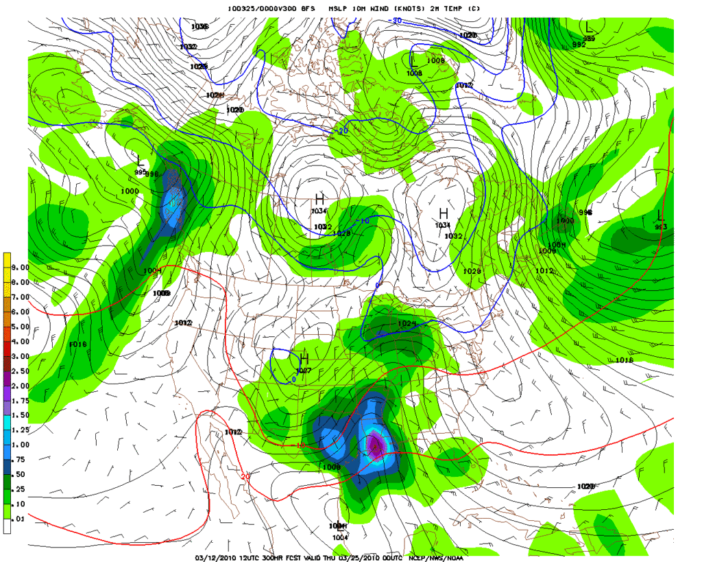
Interestingly guidance suggests a very stormy pattern for Easter weekend as a very deep trough forms out W and a stout ridge builds in the E. It appears that a frontal boundry will stall near E TX/W LA on Easter Sunday. HPC Morning Update also suggests things could become rather stormy in TX and the Southern Plains with this clash of airmasses.

Image

PRELIMINARY EXTENDED FORECAST DISCUSSION
NWS HYDROMETEOROLOGICAL PREDICTION CENTER CAMP SPRINGS MD
740 AM EDT SAT MAR 27 2010

VALID 12Z WED MAR 31 2010 - 12Z SAT APR 03 2010

LATEST GUIDANCE CONTINUES THE THEME OF A VERY ACTIVE ERN PAC THRU
CNTRL NOAM PATTERN WHILE DOWNSTREAM RIDGING INTO ERN NOAM SHOULD
GRADUALLY PUSH AWAY A SLOW MOVING SYSTEM FCST TO BE NEAR THE EAST
COAST TUE-WED. WITH BOTH ERN PAC/WRN NOAM FLOW AND THE EAST COAST
SYSTEM... THE 00Z GFS IS GENERALLY NOT AS EXTREME COMPARED TO THE
CURRENT MODEL/ENSEMBLE SPREAD AS THE GFS WAS 24 HRS AGO BUT ENOUGH
QUESTION MARKS EXIST TO FAVOR LEANING AWAY FROM ITS DETAILS FOR
THE MEDIUM RANGE FCST.

STARTING FROM VERY LATE IN THE SHORT RANGE PERIOD... CONSENSUS OF
00Z MODELS AND 12Z ECMWF/CANADIAN ENSEMBLES INDICATES A PREFERENCE
TOWARD AN OVERALL ERN PAC/WRN NOAM TROF THAT IS SLIGHTLY BROADER
THAN THE 00Z GFS DURING THE FIRST HALF OF THE MEDIUM RANGE PERIOD.
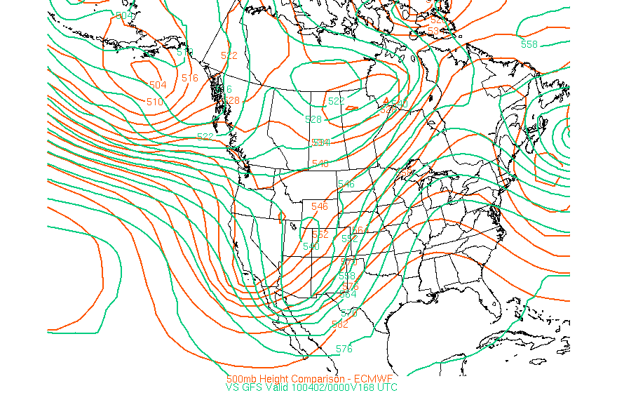
AS THE TROF CROSSES THE WEST AND EJECTS INTO THE PLAINS... THE
GFS AND GEFS MEAN ARE THE FASTEST SOLNS AND THE 00Z ECMWF/UKMET
AND 12Z ECMWF ENS MEAN ARE SLOWEST. BASED ON RECENT EXPERIENCE
THE ECMWF MAY RUN THE RISK OF BEING A LITTLE TOO SLOW BUT THE
AMPLIFIED LARGE SCALE PATTERN WOULD SUGGEST THAT TIMING IN THE
SLOWER HALF OF THE SOLN ENVELOPE IS PROBABLY BEST. BEHIND THIS
SYSTEM THE GFS IS ON THE FAST EDGE OF GUIDANCE WITH UPSTREAM
ENERGY REACHING THE WEST COAST BY LATE THU NIGHT OR FRI.

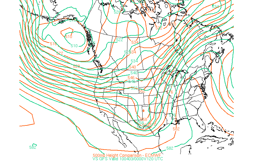
WITH THE SYSTEM GRADUALLY DRIFTING AWAY FROM THE EAST COAST...
LATE IN THE SHORT RANGE PERIOD THE 00Z ECMWF TRENDED DEEPER TO THE
CANADIAN SOLN. DEEP BIASES IN THE CMC QUESTION THE DEPTH ALOFT
AND EXTREME WWD SFC POSN OF THE ECMWF/CMC AS OF EARLY DAY 3 TUE.
ON THE OTHER HAND THE GFS LEANS TO THE ERN SIDE OF THE SPREAD.
CONTINUITY/TRENDS OF GUIDANCE AS A WHOLE AND SEPARATION OF THIS
SYSTEM FROM NRN STREAM FLOW FAVOR A SOLN IN THE SLOWER HALF OF THE
ENVELOPE WITH THE 12Z ECMWF PROVIDING A MORE MODERATE
REPRESENTATION OF THIS PREFERENCE COMPARED TO THE 00Z ECMWF/CMC
EARLY IN THE PERIOD.

EARLY PRELIMS USE FOR THE FCST FOR DAYS 3-4 TUE-WED STARTS WITH A
NEARLY EVEN BLEND OF THE 00Z ECMWF/12Z ECMWF/12Z ECMWF ENSEMBLE
MEAN TO PROVIDE GREATER EMPHASIS ON 12Z ECMWF DATA FOR THE SYSTEM
NEAR THE EAST COAST AND TO REPRESENT THE PRIMARY NON-GFS
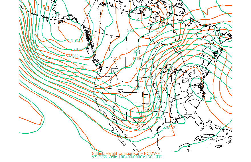
CLUSTERING FARTHER WWD. DAYS 5-7 THU-SAT ADJUST TO A SIMPLER 00Z
ECMWF/12Z ECMWF ENSEMBLE MEAN BLEND AS THE BEST WAY TO CAPTURE THE
SLOWER HALF OF THE SOLN SPREAD WITH ERN PAC TO CNTRL NOAM FLOW AND
THE SYSTEM DEPARTING FROM THE EAST COAST.

UPDATED MORNING PRELIMS FOLLOW SAME PATTERN WITH A SUBSTITUTION OF
THE 00Z ECMWF ENS MEAN FOR PRIOR 12Z EC MEAN. SOME MINOR FRONTAL
CHANGES OCCUR IN THE NRN PLAINS/UPPER MS VALLEY OTHERWISE
FEATURES/FRONTS REMAIN THE SAME.

A SIGNIFICANT COOLING IN STORE FOR WRN CONUS WITH THE DEEP WRN
TROF AND CLOSED LOW DROPING SOUTHEAST AND SWINGING THRU THEH
SOUTHWEST ALONG WITH WET CONDITIONS OVER THE PAC NORTHWEST
SHIFTING SOUTHWARD THRU CA AND EWD THRU THE ROCKIES AND INTO THE
NRN PLAINS MID-LATE WEEK. SLOW MOVING N-S FRONTAL BOUNDARY THRU
THE CENTRAL PLAINS NWD INTO THE UPPER MS VALLEY LIKELY TO BE THE
FOCUS OF SOME HVY RAINFALL AND STRONG CONVECTION FRI INTO SUNDAY
WITH A STRONG BAROCLINIC CLASH OF A COLD TROF AND SIGNIFICANT WARM
ADVECTION AHEAD OF IT THRU THE SRN PLAINS ALONG WITH GOOD INFLOW
OF GULF MOISTURE SPREADING WELL NWD OVER A PERIOD OF DAYS.

EASTWARD HVY RAIN EVENT SETTING UP DAY 3 TUES VA-NEW ENG WITH
CONSIDERABLE DRYING AND WARMING FOLLOWING AS MID LEVEL HTS RISE
AND STRONG WARM ADVECTION OCCURS FROM THE MS VALLEY EWD TO THE
EAST COAST BY THE WEEKEND. FIRST TRUE WIDESPREAD WARMING EVENT OF
THE SPRING TO OCCUR LATE WEEK INTO EASTER WEEKEND. GREATEST
TEMPERATURE ANOMALIES TO OCCUR FROM NEW ENG TO THE GREAT LAKES
REGION WHERE H850 TEMP ANOMALIES ARE IN THE RANGE OF THREE
STANDARD DEVIATIONS ABOVE NORMAL YIELDING A LARGE AREA OF TEMPS IN
THE 60-70S OVER THIS AREA WITH UPPER 70S-LOW 80S COMMON SOUTHWARD
FROM THE NORTHEAST TO OH VALLEY AND SOUTH TO THE GULF COAST.

RAUSCH/ROSENSTEIN
0 likes   
Carla/Alicia/Jerry(In The Eye)/Michelle/Charley/Ivan/Dennis/Katrina/Rita/Wilma/Ike/Harvey

Member: National Weather Association
Wx Infinity Forums
http://wxinfinity.com/index.php

Facebook.com/WeatherInfinity
Twitter @WeatherInfinity

Peanut432
Tropical Storm
Tropical Storm
Posts: 119
Joined: Mon Jan 25, 2010 10:21 pm
Location: Hollis Ok

#18 Postby Peanut432 » Sun Mar 28, 2010 5:35 pm

LBK AFD is saying a possible dynamic spring storm setting up for Thursday or Friday. The temps are supposed to be in the 80 with good moisture inflow. Looks as though the dryline will be active with already 40% thunderstorm chance this far out. Triple point??????
0 likes   

User avatar
srainhoutx
S2K Supporter
S2K Supporter
Posts: 6919
Age: 67
Joined: Sun Jan 14, 2007 11:34 am
Location: Haywood County, NC
Contact:

Re:

#19 Postby srainhoutx » Sun Mar 28, 2010 7:51 pm

Peanut432 wrote:LBK AFD is saying a possible dynamic spring storm setting up for Thursday or Friday. The temps are supposed to be in the 80 with good moisture inflow. Looks as though the dryline will be active with already 40% thunderstorm chance this far out. Triple point??????


Not too sure if we can know that a Triple Point senario will play out this far in advance, but there is growing concern that a significant threat may lie ahead beginning on Good Friday throughout the Easter Weekend. May need a thread of it's own in the next couple of days. :wink:
0 likes   
Carla/Alicia/Jerry(In The Eye)/Michelle/Charley/Ivan/Dennis/Katrina/Rita/Wilma/Ike/Harvey

Member: National Weather Association
Wx Infinity Forums
http://wxinfinity.com/index.php

Facebook.com/WeatherInfinity
Twitter @WeatherInfinity

User avatar
srainhoutx
S2K Supporter
S2K Supporter
Posts: 6919
Age: 67
Joined: Sun Jan 14, 2007 11:34 am
Location: Haywood County, NC
Contact:

Re: Southern Plains (TX/OK) Weather Megathread - 2010

#20 Postby srainhoutx » Mon Mar 29, 2010 9:11 am

A bit of a change in the overnight guidance. The GFS and ECMWF are more in line with open trough than a closed low that the GFS has depicted the past several runs and the ECMWF has switched from moving the Upper Low NE from the Panhandle and stalling the front to moving everything E on Saturday Morning. The SPC is mentioning the fact the there will likely be some severe weather with the Dryline/Cold Front that will sweep across TX and maybe the Southern Plains on Good Friday and off the TX Coast on Saturday morning. The 00Z GFS does close off the Upper Low over E TX as slowly moves it ENE. Regardless as of Monday (3/29) it does appear that there could be some very active weather over the Easter Holidays from TX and the Southern Plains and points east.

Image

DAY 4-8 CONVECTIVE OUTLOOK
NWS STORM PREDICTION CENTER NORMAN OK
0350 AM CDT MON MAR 29 2010

VALID 011200Z - 061200Z

...DISCUSSION...
ERN CONUS RIDGING WILL OCCUR N OF HEIGHT WEAKNESS LOCATED ACROSS
PORTIONS SERN GULF...YUCATAN AND WRN CUBA AREA -- SHOWN TO SOME
EXTENT IN ALL OPERATIONAL MODELS...MANY MREF MEMBERS...AND IN
SPECTRAL/UKMET MODELS...CLOSED 500 MB LOW BY DAY-4/1ST-2ND.
MEANWHILE...STG TROUGH MAKING LANDFALL CA COAST LATE DAY-3 INTO
DAY-4 SHOULD TRACK SEWD THEN EWD ACROSS LOWER CO RIVER VALLEY AND AZ
DAY-4...WITH VERY STG AGREEMENT THERE AMONG ALL OPERATIONAL MODELS
AND MOST SREF PROGS. BY 3/00Z DAY-5...THIS TROUGH SHOULD CROSS W
TX...PERHAPS INCLUDING CLOSED 500 MB LOW...AS PRECEDING SWLY FLOW
ENTRAINS AT LEAST PART OF SERN GULF VORTICITY PLUME. STRONG
ELEVATED MIXED LAYER WILL BE IN PLACE OVER SRN PLAINS AHEAD OF
EJECTING TROUGH...GIVEN SEVERAL PRECEDING DAYS OF SWLY FLOW OFF WRN
PLATEAU/MOUNTAINS.

LITTLE DOUBT REMAINS THAT SOME SVR IS PROBABLE DURING DAYS 4-5 OVER
PORTIONS SRN PLAINS...ESPECIALLY ACROSS TX...GIVEN INCREASING
LIKELIHOOD THAT STG DEEP-LAYER FLOW WILL SPREAD ACROSS SOME PARTS OF
MOIST SECTOR SE OF FRONTAL ZONE AND E OF DRYLINE. HOWEVER...IT
STILL IS TOO SOON TO PEG SPECIFIC AREAS OF COVERAGE AT 30%
PROBABILISTIC CONCENTRATIONS GIVEN LINGERING DIFFERENCES IN PROGS OF


1. SFC MASS-FIELD RESPONSES FROM MID-LATE DAY-4 ONWARD...
2. QUALITY AND WIDTH OF RETURN-FLOW MOIST SECTOR POTENTIALLY
SUITABLE FOR SVR...AND
3. SOMEWHAT RELATED PROSPECTS FOR NARROWED MOIST SECTOR AND
ANTECEDENT GULF PRECIP RELATED TO PERTURBATION THERE.

..EDWARDS.. 03/29/2010
0 likes   
Carla/Alicia/Jerry(In The Eye)/Michelle/Charley/Ivan/Dennis/Katrina/Rita/Wilma/Ike/Harvey

Member: National Weather Association
Wx Infinity Forums
http://wxinfinity.com/index.php

Facebook.com/WeatherInfinity
Twitter @WeatherInfinity


Return to “USA & Caribbean Weather”

Who is online

Users browsing this forum: No registered users and 31 guests