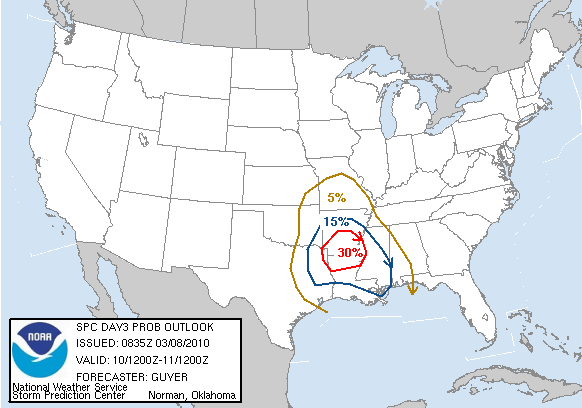
2010 Tornado Season

U.S. & Caribbean Weather Discussions and Severe Weather Events

Moderator: S2k Moderators

Forum rules

The posts in this forum are NOT official forecast and should not be used as such. They are just the opinion of the poster and may or may not be backed by sound meteorological data. They are NOT endorsed by any professional institution or STORM2K.

Help Support Storm2K
Message
Author
User avatar
srainhoutx
S2K Supporter
S2K Supporter
Posts: 6919
Age: 67
Joined: Sun Jan 14, 2007 11:34 am
Location: Haywood County, NC
Contact:

Re: Re:

#21 Postby srainhoutx » Thu Mar 04, 2010 8:33 am

Cookie wrote:
CrazyC83 wrote:The tornado-free month has been BROKEN - Confirmed EF0 in Kern County, California on February 27.


do you have a link to this information?


:wink:

http://www.spc.noaa.gov/climo/reports/100227_rpts.html
0 likes   
Carla/Alicia/Jerry(In The Eye)/Michelle/Charley/Ivan/Dennis/Katrina/Rita/Wilma/Ike/Harvey

Member: National Weather Association
Wx Infinity Forums
http://wxinfinity.com/index.php

Facebook.com/WeatherInfinity
Twitter @WeatherInfinity

User avatar
KWT
Category 5
Category 5
Posts: 31415
Joined: Tue Aug 17, 2004 11:02 am
Location: UK!!!

#22 Postby KWT » Fri Mar 05, 2010 10:58 am

Seems to be a risk of some severe conditions with the upper low in the plains next week though there are some obvious disagreements still to be ironed out. Looks like a cold core set-up with some pretty potent cold air aloft which means temps won't need to be that impressive to spark things off.
0 likes   
Personal Forecast Disclaimer:
The posts in this forum are NOT official forecast and should not be used as such. They are just the opinion of the poster and may or may not be backed by sound meteorological data. They are NOT endorsed by any professional institution or storm2k.org. For official information, please refer to the NHC and NWS products

User avatar
Cookie
S2K Supporter
S2K Supporter
Posts: 477
Age: 37
Joined: Sun Dec 14, 2008 11:13 am
Location: Isle Of lewis scotland

Re: Re:

#23 Postby Cookie » Fri Mar 05, 2010 4:19 pm

srainhoutx wrote:
Cookie wrote:
CrazyC83 wrote:The tornado-free month has been BROKEN - Confirmed EF0 in Kern County, California on February 27.


do you have a link to this information?


:wink:

http://www.spc.noaa.gov/climo/reports/100227_rpts.html


thanks mate
0 likes   

User avatar
srainhoutx
S2K Supporter
S2K Supporter
Posts: 6919
Age: 67
Joined: Sun Jan 14, 2007 11:34 am
Location: Haywood County, NC
Contact:

Re: 2010 Tornado Season

#24 Postby srainhoutx » Mon Mar 08, 2010 8:17 am

Image

DAY 3 CONVECTIVE OUTLOOK
NWS STORM PREDICTION CENTER NORMAN OK
0235 AM CST MON MAR 08 2010

VALID 101200Z - 111200Z

...THERE IS A SLGT RISK OF SVR TSTMS ACROSS SOUTHEAST OK/ARKLATEX TO
LOWER MS RIVER VALLEY...

...EAST TX/SOUTHEAST OK TO LOWER MS RIVER VALLEY...
IN ASSOCIATION WITH A POTENT UPPER TROUGH THAT IS FORECAST TO
ADVANCE NORTHEASTWARD FROM THE SOUTHERN HIGH PLAINS TO THE OZARKS
VICINITY...IT APPEARS AN APPRECIABLE SEVERE POTENTIAL WILL EXIST
ACROSS PORTIONS OF EAST TX/SOUTHEAST OK TO THE ARKLATEX/LOWER MS
RIVER VALLEY ON WEDNESDAY. WITH A RELATIVELY MOIST AIRMASS REMAINING
IN PLACE ACROSS THE ARKLATEX/LOWER MS VALLEY IN THE WAKE OF
TODAYS/TUESDAYS UPPER TROUGH OVER THE MIDWEST...INCREASING LARGE
SCALE FORCING FOR ASCENT/STRENGTHENING WIND FIELDS ALOFT SHOULD
SUPPORT INCREASING SEVERE TSTM DEVELOPMENT DURING THE MID/LATE
AFTERNOON HOURS OF WEDNESDAY INITIALLY ACROSS THE ARKLATEX VICINITY.
SUFFICIENT LOW LEVEL MOISTURE/INSTABILITY AND STRONG/VEERING FLOW
THROUGH THE LOW/MID TROPOSPHERE WILL SUPPORT AN INITIAL MODE OF
SUPERCELLS WITH SEVERE HAIL/TORNADO POTENTIAL. BUT GIVEN THE DEGREE
OF LARGE SCALE FORCING/HEIGHT FALLS...IT SEEMS LIKELY THAT STORMS
SHOULD EVOLVE INTO A QUASI-LINEAR CONVECTIVE SYSTEM BY EARLY
EVENING...WITH A CONTINUED DAMAGING WIND/TORNADO RISK QUICKLY
SPREADING EAST-NORTHEASTWARD TOWARD THE LOWER MS RIVER VALLEY.
ADDITIONAL BOUTS OF SEVERE TSTMS WILL ALSO BE POSSIBLE FARTHER
SOUTHEAST ALONG THE CENTRAL GULF COAST VICINITY...PERHAPS MAINLY
WEDNESDAY NIGHT.

...EASTERN OK/FAR SOUTHEAST KS TO OZARKS/LOWER MO RIVER VALLEY...
OTHER LOWER TOPPED SEVERE STORMS WILL POSSIBLE MAINLY ACROSS
PORTIONS OF EASTERN OK/NORTHERN AR/SOUTHERN MO IN CLOSER PROXIMITY
TO THE NORTHEAST ADVANCING UPPER SYSTEM. BOUNDARY LAYER MOISTURE
/50S F/ WILL BE MORE LIMITED ACROSS THIS REGION...BUT IT APPEARS
LIKELY THAT SURFACE BASED TSTM DEVELOPMENT WILL OCCUR AHEAD OF THE
COMPACT UPPER TROUGH AND ALONG/SOUTH OF A STALLED
SOUTHWEST-NORTHEAST ORIENTED FRONT. WHILE LAPSE RATES WILL BE STEEP
AND VERTICAL SHEAR WILL BE STRONG...UNCERTAINTY REGARDING THE DEGREE
OF MOISTURE/INSTABILITY PRECLUDES SLIGHT RISK CALIBER SEVERE
PROBABILITIES AT THIS TIME.

..GUYER.. 03/08/2010
0 likes   
Carla/Alicia/Jerry(In The Eye)/Michelle/Charley/Ivan/Dennis/Katrina/Rita/Wilma/Ike/Harvey

Member: National Weather Association
Wx Infinity Forums
http://wxinfinity.com/index.php

Facebook.com/WeatherInfinity
Twitter @WeatherInfinity

User avatar
KWT
Category 5
Category 5
Posts: 31415
Joined: Tue Aug 17, 2004 11:02 am
Location: UK!!!

#25 Postby KWT » Mon Mar 08, 2010 10:35 am

Looks like that is the first semi decent severe weather for quite some time, though the risk doesn't look too high...

Still, bring on the severe season!
0 likes   
Personal Forecast Disclaimer:
The posts in this forum are NOT official forecast and should not be used as such. They are just the opinion of the poster and may or may not be backed by sound meteorological data. They are NOT endorsed by any professional institution or storm2k.org. For official information, please refer to the NHC and NWS products

User avatar
Texas Snowman
Storm2k Moderator
Storm2k Moderator
Posts: 6151
Joined: Fri Jan 25, 2008 11:29 am
Location: Denison, Texas

Re: 2010 Tornado Season

#26 Postby Texas Snowman » Mon Mar 08, 2010 7:46 pm

What I heard described as a "large wedge" tornado (on one TV report) caused damage tonight in west/central Oklahoma. By the time I saw the TV coverage, the tornado had lifted into a funnel cloud.

Here's an update from NewsOk.com:

Tornado destroys 5 homes, damages others in Hammon

Five homes were destroyed and several others damaged when a tornado passed through Hammon in Custer County this evening, the state emergency management office reported. The storm also damaged a county barn and caused other debris.


Read more: http://www.newsok.com/tornado-moves-thr ... z0hdTgWwOX
0 likes   
The above post and any post by Texas Snowman is NOT an official forecast and should not be used as such. It is just the opinion of the poster and may or may not be backed by sound meteorological data. It is NOT endorsed by any professional institution including storm2k.org. For official information, please refer to NWS products.

User avatar
somethingfunny
ChatStaff
ChatStaff
Posts: 3926
Age: 36
Joined: Thu May 31, 2007 10:30 pm
Location: McKinney, Texas

Re: 2010 Tornado Season

#27 Postby somethingfunny » Tue Mar 09, 2010 3:13 am

Yep....batten down the hatches, here we go into severe season!
0 likes   

User avatar
Bunkertor
Category 5
Category 5
Posts: 3397
Joined: Tue May 09, 2006 3:48 pm

Re: 2010 Tornado Season

#28 Postby Bunkertor » Tue Mar 09, 2010 7:51 am

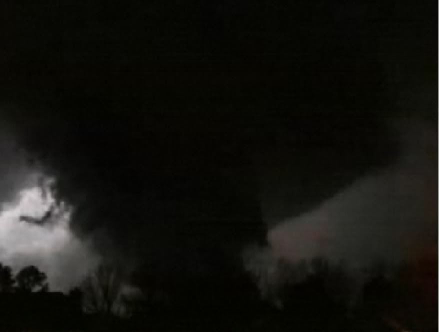
srainhoutx wrote:Brand new footage of Andover, Kansas F5 tornado April 26, 1991. Let's hope we see nothing like this infamous monster this year...

[youtube]http://www.youtube.com/watch?v=84eHnxRyEV4&feature=player_embedded[/youtube]


Hey Srain ! How can i watch this video ?
0 likes   

User avatar
Cookie
S2K Supporter
S2K Supporter
Posts: 477
Age: 37
Joined: Sun Dec 14, 2008 11:13 am
Location: Isle Of lewis scotland

#29 Postby Cookie » Tue Mar 09, 2010 12:11 pm

0 likes   

User avatar
Stephanie
S2K Supporter
S2K Supporter
Posts: 23843
Age: 62
Joined: Thu Feb 06, 2003 9:53 am
Location: Glassboro, NJ

Re: 2010 Tornado Season

#30 Postby Stephanie » Wed Mar 10, 2010 8:17 pm

Bunkertor - click on the play arrow, it'll come up with a message and then click on one of the available video pictures below it and it'll come up.
0 likes   

User avatar
Bunkertor
Category 5
Category 5
Posts: 3397
Joined: Tue May 09, 2006 3:48 pm

#31 Postby Bunkertor » Wed Mar 10, 2010 8:22 pm

Hm, thanks Stephanie ! I managed to see it. But is it brand new ? :double:
0 likes   

User avatar
leaf blower
Tropical Low
Tropical Low
Posts: 39
Joined: Mon Jul 21, 2008 8:01 am

Re: 2010 Tornado Season

#32 Postby leaf blower » Wed Mar 10, 2010 8:57 pm

Im watching these streams

http://cfc.katv.com/katvlivestream.cfm

http://www.tornadovideos.net/full-scree ... -video.php

If anyone has any other live streams they'd be much appreciated

somebody posted this image in

Image
0 likes   

User avatar
Stephanie
S2K Supporter
S2K Supporter
Posts: 23843
Age: 62
Joined: Thu Feb 06, 2003 9:53 am
Location: Glassboro, NJ

Re: 2010 Tornado Season

#33 Postby Stephanie » Wed Mar 10, 2010 8:58 pm

Is what brand new - the tornado or the videos?

There's a lot of great videos in that link of various monster tornados, including Moore, OK.
0 likes   

User avatar
leaf blower
Tropical Low
Tropical Low
Posts: 39
Joined: Mon Jul 21, 2008 8:01 am

Re: 2010 Tornado Season

#34 Postby leaf blower » Wed Mar 10, 2010 9:04 pm

Happening now- press play in the 1st link for live news feed or the Brian emfinger hurricane tracker on the map in the 2nd link
0 likes   

User avatar
Dave
Retired Staff
Retired Staff
Posts: 13442
Age: 74
Joined: Tue Aug 01, 2006 3:57 pm
Location: Milan Indiana
Contact:

#35 Postby Dave » Wed Mar 10, 2010 9:51 pm

Hammon, OK Tornado
Submitted by SevereStudios on Tue, 03/09/2010 - 8:25am.

http://www.youtube.com/watch?v=l_kzKP0I ... r_embedded
0 likes   

User avatar
Bunkertor
Category 5
Category 5
Posts: 3397
Joined: Tue May 09, 2006 3:48 pm

Re: 2010 Tornado Season

#36 Postby Bunkertor » Thu Mar 11, 2010 1:59 pm

Stephanie wrote:Is what brand new - the tornado or the videos?

There's a lot of great videos in that link of various monster tornados, including Moore, OK.


I thought that i had seen this one before, but OK, there are so many Videos of the Andover Tornado. Frankly, i don´t know. But it´s breathtaking.
0 likes   

User avatar
artist
Category 5
Category 5
Posts: 9792
Joined: Mon Jun 06, 2005 3:26 pm
Location: West Palm

#37 Postby artist » Thu Mar 11, 2010 2:51 pm

TORNADO WARNING
FLC009-117-127-112015-
/O.NEW.KMLB.TO.W.0017.100311T1938Z-100311T2015Z/

BULLETIN - EAS ACTIVATION REQUESTED
TORNADO WARNING
NATIONAL WEATHER SERVICE MELBOURNE FL
238 PM EST THU MAR 11 2010

THE NATIONAL WEATHER SERVICE IN MELBOURNE HAS ISSUED A

* TORNADO WARNING FOR...
NORTHERN BREVARD COUNTY IN FLORIDA...
THIS INCLUDES THE CITIES OF...SCOTTSMOOR...PLAYALINDA BEACH...
MIMS...HAULOVER CANAL...
EAST CENTRAL SEMINOLE COUNTY IN FLORIDA...
SOUTHEASTERN VOLUSIA COUNTY IN FLORIDA...
THIS INCLUDES THE CITY OF MAYTOWN...

* UNTIL 315 PM EST.

* AT 233 PM EST...NATIONAL WEATHER SERVICE METEOROLOGISTS DETECTED A
SEVERE THUNDERSTORM CAPABLE OF PRODUCING A TORNADO NEAR MAYTOWN...
MOVING EAST AT 30 MPH.

* OTHER LOCATIONS IN THE WARNING INCLUDE BUT ARE NOT LIMITED TO
KLONDIKE BEACH AND MERRITT ISLAND WILDLIFE REFUGE

PRECAUTIONARY/PREPAREDNESS ACTIONS...

IF IN MOBILE HOMES OR VEHICLES...EVACUATE THEM AND GET INSIDE A
STURDY SHELTER. IF NO SHELTER IS AVAILABLE...LIE FLAT IN THE NEAREST
DITCH OR OTHER LOW SPOT AND COVER YOUR HEAD WITH YOUR HANDS.

THE SAFEST PLACE TO BE DURING A TORNADO IS IN A STRONG BUILDING ON
THE LOWEST FLOOR...IN AN INTERIOR ROOM SUCH AS A BATHROOM OR CLOSET.
KEEP AWAY FROM WINDOWS. GET UNDER A WORKBENCH OR OTHER PIECE OF
STURDY FURNITURE. USE BLANKETS OR PILLOWS TO COVER YOUR BODY.

EVACUATE MOBILE HOMES OR VEHICLES FOR MORE SUBSTANTIAL SHELTER. IF NO
SHELTER IS AVAILABLE...LIE FLAT IN THE NEAREST DITCH OR OTHER LOW
SPOT AND COVER YOUR HEAD WITH YOUR HANDS. ABANDON YOUR VEHICLE IF THE
TORNADO IS NEARBY.

&&

LAT...LON 2860 8061 2858 8064 2862 8079 2869 8079
2871 8075 2879 8084 2862 8081 2868 8109
2886 8106 2884 8082 2874 8075 2866 8067
2867 8066 2873 8070 2875 8073 2883 8076
2883 8075 2858 8057
TIME...MOT...LOC 1937Z 280DEG 26KT 2875 8097
0 likes   

User avatar
artist
Category 5
Category 5
Posts: 9792
Joined: Mon Jun 06, 2005 3:26 pm
Location: West Palm

#38 Postby artist » Thu Mar 11, 2010 2:54 pm

000
WUUS52 KMLB 111942
SVRMLB
FLC097-112045-
/O.NEW.KMLB.SV.W.0015.100311T1942Z-100311T2045Z/

BULLETIN - EAS ACTIVATION REQUESTED
SEVERE THUNDERSTORM WARNING
NATIONAL WEATHER SERVICE MELBOURNE FL
242 PM EST THU MAR 11 2010

THE NATIONAL WEATHER SERVICE IN MELBOURNE HAS ISSUED A

* SEVERE THUNDERSTORM WARNING FOR...
OSCEOLA COUNTY IN FLORIDA

* UNTIL 345 PM EST.

* AT 240 PM EST...NATIONAL WEATHER SERVICE METEOROLOGISTS DETECTED
SEVERE THUNDERSTORMS CAPABLE OF PRODUCING QUARTER SIZE HAIL...AND
DESTRUCTIVE WINDS IN EXCESS OF 70 MPH. THIS STORMS WERE MOVING
EAST AT 30 MPH INTO WESTERN SECTIONS OF OSCEOLA COUNTY.

* OTHER LOCATIONS IN THE WARNING INCLUDE...BUT ARE NOT LIMITED
TO...POINCIANA...INTERCESSION CITY...CAMPBELL...WEST LAKE
TOHO...LAKE MARIAN...SAINT CLOUD...EAST LAKE TOHO...
KENANSVILLE...NARCOOSSEE...HARMONY AND HOLOPAW

PRECAUTIONARY/PREPAREDNESS ACTIONS...

A TORNADO WATCH REMAINS IN EFFECT FOR THE WARNED AREA. IF A TORNADO
IS SPOTTED...ACT QUICKLY AND MOVE TO A PLACE OF SAFETY IN A STURDY
STRUCTURE...SUCH AS A SMALL INTERIOR ROOM.

A TORNADO WATCH REMAINS IN EFFECT UNTIL 600 PM EST THURSDAY EVENING
FOR EAST CENTRAL FLORIDA.

&&

LAT...LON 2834 8089 2772 8087 2764 8105 2764 8114
2782 8122 2787 8131 2799 8139 2800 8141
2804 8146 2806 8145 2802 8138 2807 8135
2808 8145 2813 8146 2814 8152 2819 8152
2825 8156 2826 8166 2828 8166
TIME...MOT...LOC 1941Z 240DEG 35KT 2793 8139

$$
0 likes   

User avatar
artist
Category 5
Category 5
Posts: 9792
Joined: Mon Jun 06, 2005 3:26 pm
Location: West Palm

#39 Postby artist » Thu Mar 11, 2010 3:33 pm

000
NWUS52 KTBW 112028
LSRTBW

PRELIMINARY LOCAL STORM REPORT
NATIONAL WEATHER SERVICE TAMPA BAY AREA - RUSKIN FL
328 PM EST THU MAR 11 2010

..TIME... ...EVENT... ...CITY LOCATION... ...LAT.LON...
..DATE... ....MAG.... ..COUNTY LOCATION..ST.. ...SOURCE....
..REMARKS..

0228 PM FUNNEL CLOUD 2 NNE LAND O` LAKES 28.24N 82.44W
03/11/2010 PASCO FL TRAINED SPOTTER

SPOTTER REPORTED A FUNNEL CLOUD NORTHEAST OF LAND O LAKES
LASTING APPROX 8 MIN.
0 likes   

User avatar
KWT
Category 5
Category 5
Posts: 31415
Joined: Tue Aug 17, 2004 11:02 am
Location: UK!!!

#40 Postby KWT » Sat Mar 20, 2010 11:46 am

Thus far its been another pretty slow month for tornadoes, though there is hints from the models that there will be an increase in severe weather towards the back end of March and into early April, but we shall see!
0 likes   
Personal Forecast Disclaimer:
The posts in this forum are NOT official forecast and should not be used as such. They are just the opinion of the poster and may or may not be backed by sound meteorological data. They are NOT endorsed by any professional institution or storm2k.org. For official information, please refer to the NHC and NWS products


Return to “USA & Caribbean Weather”

Who is online

Users browsing this forum: cheezyWXguy, TomballEd and 41 guests