
Atlantic Shear
http://www.ssd.noaa.gov/PS/TROP/TCFP/da ... tatshr.png
Caribbean Shear
http://www.ssd.noaa.gov/PS/TROP/TCFP/da ... carshr.png
Atlantic Sea Surface Temperatures and Anomalies
Moderator: S2k Moderators
Forum rules

The posts in this forum are NOT official forecasts and should not be used as such. They are just the opinion of the poster and may or may not be backed by sound meteorological data. They are NOT endorsed by any professional institution or STORM2K. For official information, please refer to products from the National Hurricane Center and National Weather Service.

-
wxman57

- Moderator-Pro Met

- Posts: 23174
- Age: 68
- Joined: Sat Jun 21, 2003 8:06 pm
- Location: Houston, TX (southwest)
Re: Atlantic Sea Surface Temperatures and Anomalies
fact789 wrote:wxman57 wrote:And if the El Nino is the cause of the persistent negative NAO, then it's the cause of the warmer SSTs.
So, if El Nino trends towards neutral, could the MDR 'cool' or stabalize temperaturewise?
Only if El Nino was the sole cause of the -NAO.
0 likes
-
cycloneye

- Admin

- Posts: 149484
- Age: 69
- Joined: Thu Oct 10, 2002 10:54 am
- Location: San Juan, Puerto Rico
Re: Atlantic Sea Surface Temperatures and Anomalies
Speaking about the NAO,it will remain negative for a while.

0 likes
Visit the Caribbean-Central America Weather Thread where you can find at first post web cams,radars
and observations from Caribbean basin members Click Here
and observations from Caribbean basin members Click Here
Re: Atlantic Sea Surface Temperatures and Anomalies
drezee wrote:Quick update on 41041:
SST is 26.9
previous earliest to 26.9 2006 on May 12...Two months ahead of schedule...Man, I wish I had 2005 data!!!!!!!!!
BTW, on average of the last 4 years the SSTs rise 3.56C from this point. That means a peak 7-day average of 30.4C over the open ocean! Highest temp ever recored at the buoy was 30.3 on very light winds in '08 (7 day averave was 29.5).
0 likes
-
meteorologyman
- Category 2

- Posts: 541
- Joined: Wed Mar 15, 2006 6:48 pm
- Location: Florida, Kissimmee/St.CLoud
Re: Atlantic Sea Surface Temperatures and Anomalies
srainhoutx wrote:Just remember it takes more than SST's to "bake a cake" so to speak.
This gives me an idea. Maybe we should have a forum on "What makes/hinders a Hurricane"
such as temp for SST's and the depth, Shear levels, Moisture, how SOI, and NOA effect Hurricanes, locations off ITCZ, Dust off Africa La Nina and El-Nino etc.
(note): if we do have forum on this it won't have current data like this topic, it just for definitions and recipe for the storm with extra toppings
0 likes
Re: Atlantic Sea Surface Temperatures and Anomalies
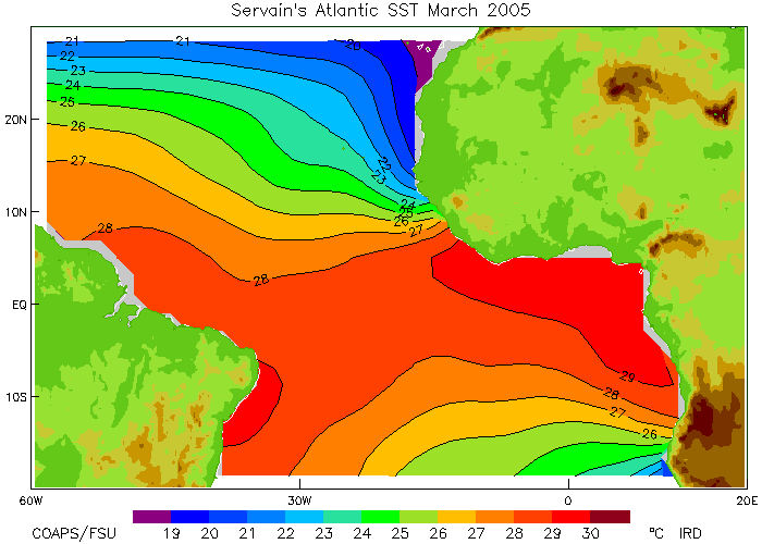
If hurricanes are the way that the environment transfers warm air to the cooler regions, then please see the temp gradient between 20N and 30N. 2005,1998, and 2010 all have this in common...
2010

2005

2009 did not have it

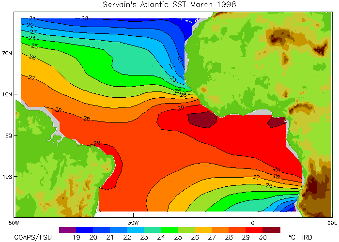
1998

2010
2005
2009 did not have it
1998
Last edited by drezee on Thu Mar 18, 2010 10:42 am, edited 1 time in total.
0 likes
Re: Atlantic Sea Surface Temperatures and Anomalies
Another Analog year of 1964 has the same pattern:
1964
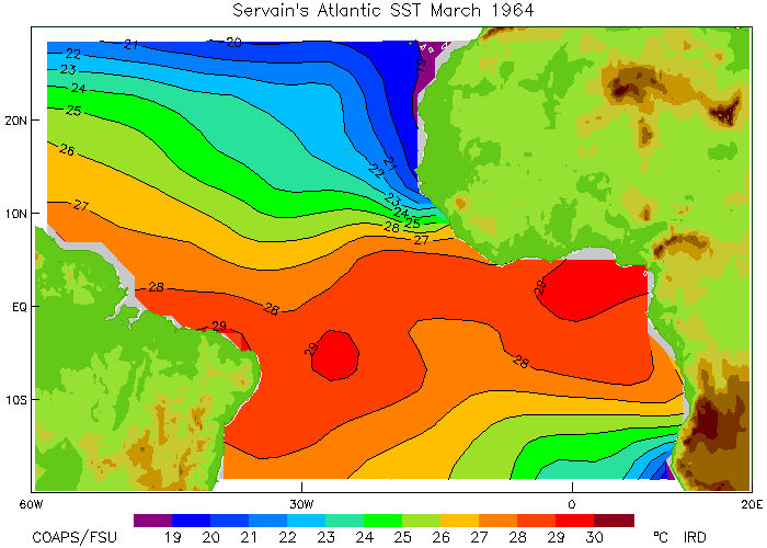
2005
1998
This is cool!
1964
2005
1998
This is cool!
0 likes


March TNA at the moment looks just a little cooler then it was in Feb with regards to the SSTAs, though its still going to up there with some of the warmest ever thats for sure!
Also that El nino does seem to be getting steadily eroded even if the core remains.
Also that El nino does seem to be getting steadily eroded even if the core remains.
0 likes
Personal Forecast Disclaimer:
The posts in this forum are NOT official forecast and should not be used as such. They are just the opinion of the poster and may or may not be backed by sound meteorological data. They are NOT endorsed by any professional institution or storm2k.org. For official information, please refer to the NHC and NWS products
The posts in this forum are NOT official forecast and should not be used as such. They are just the opinion of the poster and may or may not be backed by sound meteorological data. They are NOT endorsed by any professional institution or storm2k.org. For official information, please refer to the NHC and NWS products
-
Hurricaneman

- Category 5

- Posts: 7404
- Age: 45
- Joined: Tue Aug 31, 2004 3:24 pm
- Location: central florida
Re: Atlantic Sea Surface Temperatures and Anomalies
I think that if el nino weakens to even a .3 neutral and the gradient at 30 north with the atlantic ssta's stays in place I personally think that there's going to be a parade of cape verde storms and maybe several major US landfalls, but I think it all depends on ENSO
The posts in this forum are NOT official forecast and should not be used as such. They are just the opinion of the poster and may or may not be backed by sound meteorological data. They are NOT endorsed by any professional institution or storm2k.org. For official information, please refer to the NHC and NWS products.
The posts in this forum are NOT official forecast and should not be used as such. They are just the opinion of the poster and may or may not be backed by sound meteorological data. They are NOT endorsed by any professional institution or storm2k.org. For official information, please refer to the NHC and NWS products.
0 likes
-
cycloneye
- Admin
- Posts: 149484
- Age: 69
- Joined: Thu Oct 10, 2002 10:54 am
- Location: San Juan, Puerto Rico
Re: Atlantic Sea Surface Temperatures and Anomalies
The MDR is boiling.

0 likes
Visit the Caribbean-Central America Weather Thread where you can find at first post web cams,radars
and observations from Caribbean basin members Click Here
and observations from Caribbean basin members Click Here


Re: Atlantic Sea Surface Temperatures and Anomalies
Wow! I know that heat potential isn't the be all and end all of tropical cyclone formation, but this map is solidly ahead of even 2005 at this time of year.
0 likes
-
SouthFloridawx

- S2K Supporter

- Posts: 8346
- Age: 47
- Joined: Tue Jul 26, 2005 1:16 am
- Location: Sarasota, FL
- Contact:

-
cycloneye
- Admin
- Posts: 149484
- Age: 69
- Joined: Thu Oct 10, 2002 10:54 am
- Location: San Juan, Puerto Rico
Re: Atlantic Sea Surface Temperatures and Anomalies

0 likes
Visit the Caribbean-Central America Weather Thread where you can find at first post web cams,radars
and observations from Caribbean basin members Click Here
and observations from Caribbean basin members Click Here
-
Aric Dunn
- Category 5
- Posts: 21238
- Age: 43
- Joined: Sun Sep 19, 2004 9:58 pm
- Location: Ready for the Chase.
- Contact:
Re: Atlantic Sea Surface Temperatures and Anomalies
cycloneye wrote:The MDR is boiling.
I cant recall anytime from my memory that the cape verde islands stayed at 26 C nearly all winter !! the eastern atlantic is as everyone has stated clearly above average.. slight understatement of course..
It is one of the question i will be asking at the National Hurricane Conference and FL governs conference..
0 likes
The worrying thing is typically when you have very warm SST's in the E.atlantic there is a weak correlation between that and a very warm W.Atlantic in the summer. This suggests there is a threat that those anomalies will shift westwards with time. I think that occured in 2005 as well...
0 likes
Personal Forecast Disclaimer:
The posts in this forum are NOT official forecast and should not be used as such. They are just the opinion of the poster and may or may not be backed by sound meteorological data. They are NOT endorsed by any professional institution or storm2k.org. For official information, please refer to the NHC and NWS products
The posts in this forum are NOT official forecast and should not be used as such. They are just the opinion of the poster and may or may not be backed by sound meteorological data. They are NOT endorsed by any professional institution or storm2k.org. For official information, please refer to the NHC and NWS products
-
Blown Away

- S2K Supporter
- Posts: 10253
- Joined: Wed May 26, 2004 6:17 am
Re: Atlantic Sea Surface Temperatures and Anomalies
During a strong El Nino event don't we usually see warm SST's in the MDR due to a weak Bermuda/Azores high? The result of the weak high is weaker trade winds not upwelling cooler water in the MDR. If there is a transition into a La Nina I think the Bermuda High normally moves closer to the EC. Lots of factors that could potentially make for a busy landfall season for the Caribbean and CONUS. Not excited for landfalls, but I'm getting pumped about the 2010 season!! 
0 likes
Hurricane Eye Experience: David 79, Irene 99, Frances 04, Jeanne 04, Wilma 05… Hurricane Brush Experience: Andrew 92, Erin 95, Floyd 99, Matthew 16, Irma 17, Ian 22, Nicole 22…
Who is online
Users browsing this forum: No registered users and 259 guests