ENSO Updates (2007 thru 2023)
Moderator: S2k Moderators
Forum rules
The posts in this forum are NOT official forecasts and should not be used as such. They are just the opinion of the poster and may or may not be backed by sound meteorological data. They are NOT endorsed by any professional institution or STORM2K. For official information, please refer to products from the National Hurricane Center and National Weather Service.
Re: ENSO Updates=Climate Prediction Center 3/15/10 update
3.4 and 4 warmed because of the Kelvin wave but that's temporary and the cool trend that started several weeks ago (before the kelvin wave) will continue. Just my amateur opinion.
0 likes
-
Derek Ortt
I'm not yet ready to buy the el nino modaki theory for Atlantic canes yet
2004 season followed a classic el-nino pattern... the deep tropics were shut down in mid-September
a non-existent SAL allowed everything to develop in August and September. We didn't have the low-level shear we had this year
2004 season followed a classic el-nino pattern... the deep tropics were shut down in mid-September
a non-existent SAL allowed everything to develop in August and September. We didn't have the low-level shear we had this year
0 likes
- cycloneye
- Admin

- Posts: 149153
- Age: 69
- Joined: Thu Oct 10, 2002 10:54 am
- Location: San Juan, Puerto Rico
Re: ENSO Updates=Models forecast neutral by early summer
The 30 day SOI index has continued to go up after the big crash of Febuary 5th when the daily index went down to -80.
Daily SOI data
http://www.longpaddock.qld.gov.au/Seaso ... SOIValues/
30 day SOI Index

Daily SOI data
http://www.longpaddock.qld.gov.au/Seaso ... SOIValues/
30 day SOI Index

0 likes
Visit the Caribbean-Central America Weather Thread where you can find at first post web cams,radars
and observations from Caribbean basin members Click Here
and observations from Caribbean basin members Click Here
- cycloneye
- Admin

- Posts: 149153
- Age: 69
- Joined: Thu Oct 10, 2002 10:54 am
- Location: San Juan, Puerto Rico
Re: ENSO Updates=Models forecast neutral by early summer
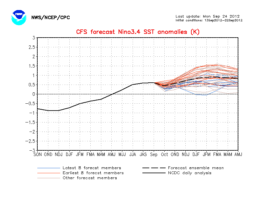
Is the first time that the CFS model goes even more cold Neutral by June.Also,almost all of the ensembles of this model are below +0.5C by June.

0 likes
Visit the Caribbean-Central America Weather Thread where you can find at first post web cams,radars
and observations from Caribbean basin members Click Here
and observations from Caribbean basin members Click Here
Interesting, the ECM is still VERY agressive with a full fledged La Nina by JJA. I think thats agressive but some of those CFS runs are almost as agressive as the ECM now.
IF La Nina forms, 1998 becomes the sole year to compare this one to.
IF La Nina forms, 1998 becomes the sole year to compare this one to.
0 likes
Personal Forecast Disclaimer:
The posts in this forum are NOT official forecast and should not be used as such. They are just the opinion of the poster and may or may not be backed by sound meteorological data. They are NOT endorsed by any professional institution or storm2k.org. For official information, please refer to the NHC and NWS products
The posts in this forum are NOT official forecast and should not be used as such. They are just the opinion of the poster and may or may not be backed by sound meteorological data. They are NOT endorsed by any professional institution or storm2k.org. For official information, please refer to the NHC and NWS products
- cycloneye
- Admin

- Posts: 149153
- Age: 69
- Joined: Thu Oct 10, 2002 10:54 am
- Location: San Juan, Puerto Rico
Re: ENSO Updates=Models forecast neutral by early summer
Australian 3/17/10 Update
El Nino is still persisting,but I enlarged a sentence about the Central Pacific that is important because is about El Nino 3.4 area.
http://www.bom.gov.au/climate/enso/
El Nino is still persisting,but I enlarged a sentence about the Central Pacific that is important because is about El Nino 3.4 area.
http://www.bom.gov.au/climate/enso/
In Brief
Central Pacific sea surface temperatures remain warmer than the long-term average.
The sub-surface water of the tropical Pacific also remains warmer than the long-term average. However, the sub-surface water in the Central Pacific has cooled over the past two weeks.
The SOI has remained steady over the past week after increasing in value after a rapid fall in February. The latest approximate 30-day value of the SOI is −8.
Trade winds are slightly weaker than normal across most of the tropical Pacific.
Cloudiness near the date-line remains well above average.
Most international computer models are predicting a return to neutral conditions during the southern hemisphere autumn.
Details
The Pacific Ocean sea surface temperature (SST) remains warmer than the long-term average across the central and eastern tropical Pacific. The SST anomaly map for February shows warm anomalies in excess of +1°C covering most of the central equatorial Pacific and parts of the eastern tropical Pacific. The monthly NINO indices for February were +0.8°C, +1.2°C and +1.0°C for NINO3, NINO3.4 and NINO4 respectively.
In terms of weekly data, the most recent NINO indices are +0.7°C, +1.2°C and +1.1°C for NINO3, NINO3.4 and NINO4 respectively. When compared with two weeks ago, NINO3 has cooled by approximately 0.2°C, while NINO3.4 and NINO4 have remained similar in value. The 7-day SST anomaly map shows warm anomalies covering most of the tropical Pacific east of 170°E. When compared with anomalies observed two weeks ago, there has been little in SST in the central equatorial Pacific. However, the surface has cooled slightly in the east, near the South American coast. An animation of recent SST changes is available.
A four-month sequence of sub-surface Pacific Ocean equatorial temperature anomaly shows a general cooling of the sub-surface since the peak in warmth during November. However, some renewed warming occurred in the central Pacific during February, in response to a weakening of the trade winds over the western and central Pacific during late January and early February. A recent map for the 5 days ending 15 March shows that the top 100 meters of the equatorial Pacific is warmer than the long-term average across the central to eastern Pacific, with anomalies exceeding +5.0°C below the surface in the eastern Pacific. When compared with two weeks ago, the central Pacific has cooled again, while the eastern Pacific has warmed slightly. An animation of recent sub-surface changes is available.
An archive of sub-surface temperature charts is available.
Trade winds have remained weak accross most of the equatorial Pacific. The latest weekly wind anomalies are shown in the TAO/TRITON map for the five days ending 15 March.
The SOI has remained steady over the past week, after increasing in value after a rapid fall during February. The current (14 March) 30-day value of the SOI is −8, while the monthly value for February was −15.
Cloudiness near the date-line across the equatorial Pacific is another important indicator of El Niño conditions, as it typically increases near and to the east of the dateline during these episodes. Cloudiness near the date-line has increased over the past fortnight and remains well above average.
Most international computer models are predicting the Pacific Ocean will cool steadily over the coming months, returing to neutral levels during the southern autumn. Typically, autumn is a transitional period for the El Niño - Southern Oscillation (ENSO), hence model predictions of El Niño that forecast through this period tend to be less reliable than at other times of the year. Recent forecasts from the POAMA model, run daily at the Bureau of Meteorology, show a steady cooling of the central Pacific with SSTs returning to neutral conditions during the southern hemisphere autumn.
0 likes
Visit the Caribbean-Central America Weather Thread where you can find at first post web cams,radars
and observations from Caribbean basin members Click Here
and observations from Caribbean basin members Click Here
- cycloneye
- Admin

- Posts: 149153
- Age: 69
- Joined: Thu Oct 10, 2002 10:54 am
- Location: San Juan, Puerto Rico
Re: ENSO Updates=Models forecast neutral by early summer
Arkestra wrote:What means SOI?
At link below is an explanation about what the SOI (Southern Oscilation Index) is.
http://www.bom.gov.au/climate/glossary/soi.shtml
0 likes
Visit the Caribbean-Central America Weather Thread where you can find at first post web cams,radars
and observations from Caribbean basin members Click Here
and observations from Caribbean basin members Click Here
- cycloneye
- Admin

- Posts: 149153
- Age: 69
- Joined: Thu Oct 10, 2002 10:54 am
- Location: San Juan, Puerto Rico
Re: ENSO Updates=Models forecast neutral by early summer
March update of all the ENSO Models by IRI
http://iri.columbia.edu/climate/ENSO/cu ... table.html


http://iri.columbia.edu/climate/ENSO/cu ... table.html


Technical ENSO Update
18 March 2010
> Current conditions
> Expected conditions
Current Conditions
As of mid-March 2010, SSTs are still well above-average throughout the central and most of the eastern equatorial Pacific, indicative of moderate El Niño conditions. Weak El Niño conditions emerged in mid-June and lasted until October, when they increased to moderate to strong levels due to the accumulated effects of intermittently strong westerly wind anomalies in the western and/or central Pacific. The traditional Southern Oscillation Index (SOI) became negative during October, and has remained negative since then. The equatorial SOI also became negative in October, returned to near-average during November and December, then becomame strongly negative in January and February. Positive convection anomalies were observed intermittently near and just west of the dateline between June and September, and became somewhat stronger and more persistent since October. Since late January, the convection anomalies became stronger and have been located near and just east of the dateline so as to efficiently influence the zonal and meridional atmospheric circulation patterns in the manner observed during previous moderate to strong El Nino episodes. Equatorial Pacific oceanic heat content had been above-average since early in 2009, and became more strongly so after October. During January and early February 2010 the heat content anomaly somewhat decreased, but since mid-February has not decreased further, remaining well above average. This pause in the depletion of anomalous sub-surface heat portends a likely continuation of positive SST anomalies during the remainder of March and possibly through much of April.
For February 2009, the SST anomaly in the NINO3.4 region was 1.23 C, sufficient to be classified as moderate El Niño conditions for this time of year. For the Dec-Jan-Feb season the anomaly was 1.54 degrees C. Currently the IRI's definition of El Niño conditions rests on an index of SST anomalies, averaged over the NINO3.4 region (5S-5N; 170W-120W), exceeding the warmest 25%-ile of the historical distribution, and similarly for La Niña relative to the 25%-ile coldest conditions in the historical distribution. The NINO3.4 anomaly necessary to qualify as La Niña or El Niño conditions for the Mar-Apr-May and the Apr-May-Jun seasons are approximately (-0.40C, 0.40) and (-0.45, 0.45), respectively.
Expected Conditions
The most recent weekly SST anomaly in the NINO3.4 region is 1.2 C, indicating moderate El Niño conditions in the tropical Pacific, essentially unchanged from the 1.23 C level observed in February. What is the outlook for the ENSO status going forward? Although the spatial pattern of SST anomalies and subsurface temperature anomalies became similar to those reminiscent of El Niño events somewhat late in this ENSO cycle (January and February), they have done so with considerable anomaly magnitude, representing greater late-cycle endurance of the event than observed in some past events of similar strength. Postitive convection anomalies continue presently near and just east of the dateline. Owing to the air-sea coupling associated with this canonical configuration, the atmosphere has been acting as previously observed during moderate to strong El Nino events in terms of teleconnection patterns of climate both near and remote from the tropical Pacific.
March is the time of year when existing ENSO events are often in their waning phase, and typically either dissipate or persist for up to two subsequent months. For this event, it seems most likely that El Niño conditions will persist at least through April 2010, and, given the still moderately strong subsurface anomalies resulting from the strong westerly wind anomalies from late January through February, may endure through early or middle May. While persistence of El Niño conditions through a good portion of northern spring seems likely, a double-year event (such as what occurred in 1986-87-88) does not appear likely, as negative subsurface sea temperature anomalies reside in the western tropical Pacific, and the downwelling Kelvin wave associated with the above-mentioned zonal wind anomalies will have reached the South American coast by the end of May (still within the northern spring transition period), with no additional wind-induced pulses in view at present.
Presently, the models and observations taken together indicate probabilities of about 85% for maintaining El Niño conditions and about 14% for dissipation to ENSO-neutral conditions for the Mar-Apr-May season in progress. Going forward, probabilities for El Niño decrease to approximately 50% by Apr-May-Jun, falling to climatological probabilities of 25% by Jun-Jul-Aug. Probabilities for La Niña conditions are predicted to be negligible until May-Jun-Jul, when they rise to 10%. By Jul-Aug-Sep, the probability for La Niña begins exceeding that for El Niño, and during the later portion of 2010 the La Niña and El Niño probabilities become 30% and 20%, respectively.
The above assessment was made in part on the basis of an examination of the current forecasts of ENSO prediction models as well as the observed conditions. For purposes of this discussion, El Niño SST conditions are defined as SSTs in the NINO3.4 region being in the warmest 25% of their climatological distribution for the 3-month period in question over the 1950-present timeframe. The corresponding cutoff in terms of degrees C of SST anomaly varies seasonally, being close to 0.40 degrees C in boreal late-spring to early-summer season and as high as 0.75 degrees C in late boreal autumn. La Niña conditions are defined as NINO3.4 region SSTs being in the coolest 25% of the climatological distribution. Neutral conditions occupy the remaining 50% of the distribution. These definitions were developed such that the most commonly accepted El Niño and La Niña episodes are reproduced.
The models are in rough agreement in their ENSO forecasts through the first few seasons of the 10-month forecast period, but show large differences beginning in northern summer. The statistical and dynamical models agree in predicting weakening El Niño conditions during the next 1 to 3 months. However, the details of the timing and the rate of dissipation differ among models, and there is great disagreement in the outlook for the coming ENSO cycle from northern summer onward: Some models predict neutral ENSO, some La Nina, and some a second year of El Nino. For the current Mar-Apr-May season, 90% of the models are predicting El Niño conditions; none predict ENSO-neutral conditions. At lead times of 4 or more months into the future, statistical and dynamical models that incorporate information about the ocean's observed sub-surface thermal structure generally exhibit higher predictive skill than those that do not. Among models that do use sub-surface temperature information, 3 of 13 (23%) indicate El Niño conditions for the Jul-Aug-Sep season, 9 of 13 (69%) predict ENSO-neutral SSTs, and 1 of 13 (8%) predict La Niña conditions. (Note 1). Caution is advised in interpreting the distribution of model forecasts as the actual probabilities. At longer leads, the skill of the models degrades, and skill uncertainty must be convolved with the uncertainties from initial conditions and differing model physics, leading to more climatological probabilities in the long-lead ENSO Outlook than might be suggested by the suite of models. Furthermore, the expected skill of one model versus another has not been established using uniform validation procedures, which may cause a difference in the true probability distribution from that taken verbatim from the raw model predictions.
An alternative way to assess the probabilities of the three possible ENSO conditions is to use the mean of the forecasts of all models, and to construct a standard error function centered on that mean. The standard error would be Gaussian in shape, and would have its width determined by an estimate of overall expected model skill for the season of the year and the lead time. Higher skill would result in a relatively narrower error distribution, while low skill would result in an error distribution with width approaching that of the historical observed distribution. This method shows probabilities for El Niño at about 92% and 50% for Mar-Apr-May and Apr-May-Jun, respectively, declining to 22% by Jun-Jul-Aug and 18% by Jul-Aug-Sep. Probabilities for La Niña increase to 20-30% from Jul-Aug-Sep onward through Nov-Dec-Jan 2010/11. The same cautions mentioned above for the distribution of model forecasts apply to this alternative method of inferring probabilities, due to differing model biases and skills. In particular, this approach considers only the mean of the predictions, and not the range across the models, nor the ensemble range within individual models.
The IRI's probabilistic ENSO forecast takes into account the indications of this set of models, the outcome of the standard error approach described above, and additional factors such as the very latest observations that may have developed after the initialization times of some of the models. It indicates an 85% probability for El Niño conditions in the Mar-Apr-May season in progress, decreasing to near 32% for May-Jun-Jul 2010 and to 20% by Aug-Sep-Oct and the seasons to follow, while La Niña probabilities rise to 30% beginning Sep-Oct-Nov, remaining there through the rest of 2010. Neutral ENSO conditions have at least 50% likelihood from May-Jun-Jul onward.
0 likes
Visit the Caribbean-Central America Weather Thread where you can find at first post web cams,radars
and observations from Caribbean basin members Click Here
and observations from Caribbean basin members Click Here
- cycloneye
- Admin

- Posts: 149153
- Age: 69
- Joined: Thu Oct 10, 2002 10:54 am
- Location: San Juan, Puerto Rico
Re: ENSO Updates
Interesting articule about seasons after El Nino by Stu Ostro of the Weather Channel.
http://www.weather.com/outlook/weather- ... 2010-03-18
http://www.weather.com/outlook/weather- ... 2010-03-18
0 likes
Visit the Caribbean-Central America Weather Thread where you can find at first post web cams,radars
and observations from Caribbean basin members Click Here
and observations from Caribbean basin members Click Here
- cycloneye
- Admin

- Posts: 149153
- Age: 69
- Joined: Thu Oct 10, 2002 10:54 am
- Location: San Juan, Puerto Rico
Re: ENSO Updates
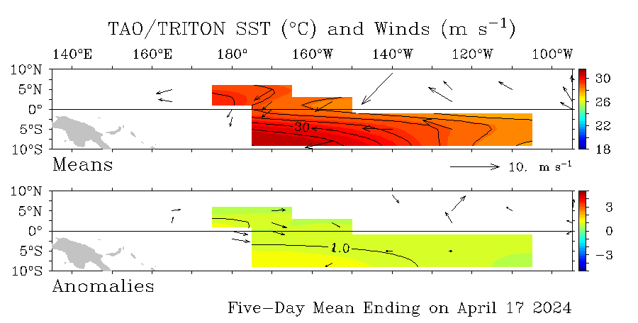
Here are interesting graphics of bouys located in the Central Pacific that show a few of them having some increase and others some decrease in temps,in other words a mixbag.


0 likes
Visit the Caribbean-Central America Weather Thread where you can find at first post web cams,radars
and observations from Caribbean basin members Click Here
and observations from Caribbean basin members Click Here
- Hurricaneman
- Category 5

- Posts: 7404
- Age: 45
- Joined: Tue Aug 31, 2004 3:24 pm
- Location: central florida
Re: ENSO Updates
It looks as though a small temporary rise in el nino, but as of the last update it looks as though the El nino will go back into the fading process as modeled
0 likes
- Kingarabian
- S2K Supporter

- Posts: 16338
- Joined: Sat Aug 08, 2009 3:06 am
- Location: Honolulu, Hawaii
@Cycloneye
http://www.prh.noaa.gov/cphc/tc_graphics/sst.php
Latest frame, it seems that the SSt's are getting warmer?
http://www.prh.noaa.gov/cphc/tc_graphics/sst.php
Latest frame, it seems that the SSt's are getting warmer?
0 likes
RIP Kobe Bryant
- cycloneye
- Admin

- Posts: 149153
- Age: 69
- Joined: Thu Oct 10, 2002 10:54 am
- Location: San Juan, Puerto Rico
Re:
Kingarabian wrote:@Cycloneye
http://www.prh.noaa.gov/cphc/tc_graphics/sst.php
Latest frame, it seems that the SSt's are getting warmer?
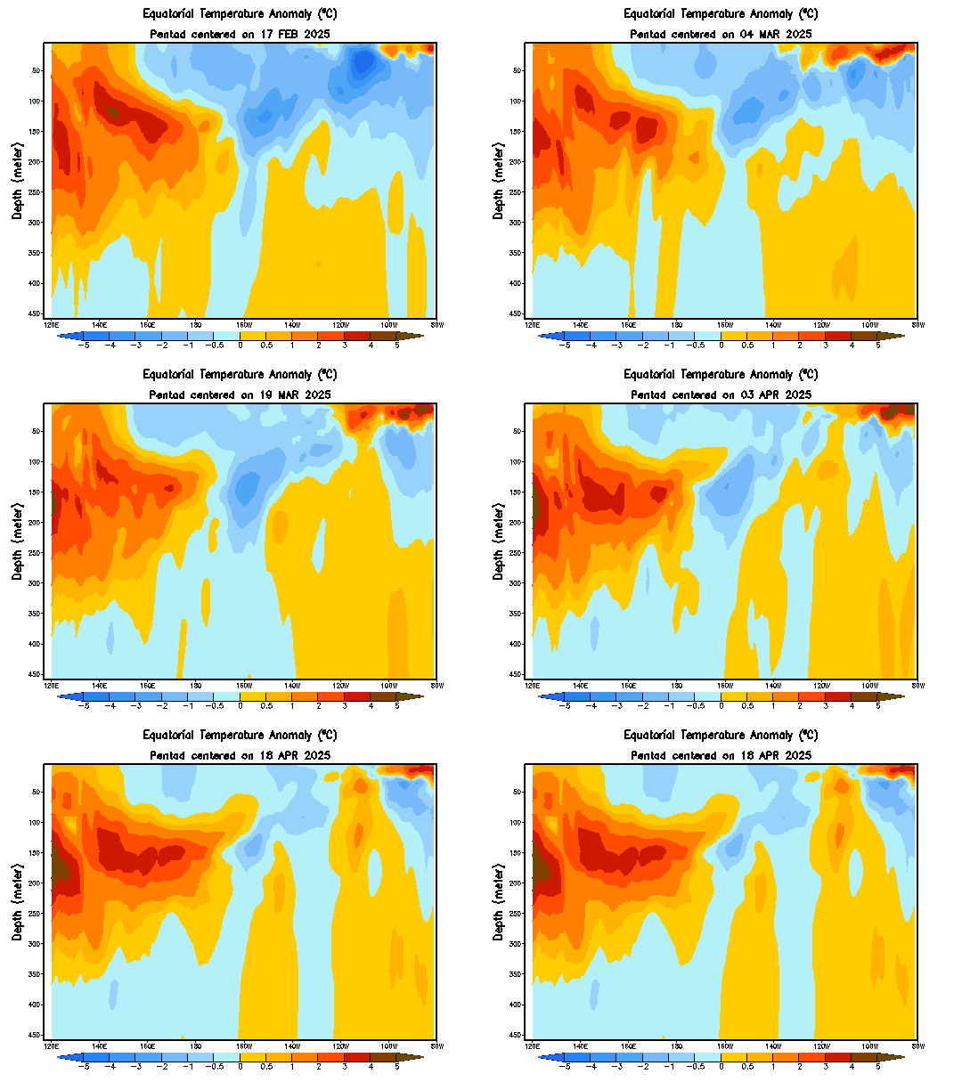
There has been a halt on the decrease of El Nino in the past 2 weeks and that causes the sst's to rise.The big question is if this halt is temporary or will last for a longer period of time,by that meaning El Nino staying during the summer months.We will have to wait and see how all of this evolves in the next 2 months.
Certainly the subsurface waters look very warm and that will rise to the surface extending the life of El Nino.
0 likes
Visit the Caribbean-Central America Weather Thread where you can find at first post web cams,radars
and observations from Caribbean basin members Click Here
and observations from Caribbean basin members Click Here
- wxman57
- Moderator-Pro Met

- Posts: 23170
- Age: 68
- Joined: Sat Jun 21, 2003 8:06 pm
- Location: Houston, TX (southwest)
Re: ENSO Updates
Pacific SSTs seem to be behaving just as forecast. I don't see any reason to think that neutral conditions won't prevail by July.
0 likes
- cycloneye
- Admin

- Posts: 149153
- Age: 69
- Joined: Thu Oct 10, 2002 10:54 am
- Location: San Juan, Puerto Rico
Re: ENSO Updates=Climate Prediction Center 3/22/10 update
Climate Prediction Center 3/22/10 update
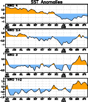
The numbers are basiclly unchanged from last week numbers.
Last Week Numbers
Niño 4= +1.2ºC
Niño 3.4= +1.2ºC
Niño 3= +0.5ºC
Niño1+2= -0.3ºC
This Week Numbers
Niño 4= +1.1ºC
Niño 3.4= +1.2ºC
Niño 3= +0.7ºC
Niño1+2= -0.1ºC
http://www.cpc.ncep.noaa.gov/products/a ... ts-web.pdf
The numbers are basiclly unchanged from last week numbers.
Last Week Numbers
Niño 4= +1.2ºC
Niño 3.4= +1.2ºC
Niño 3= +0.5ºC
Niño1+2= -0.3ºC
This Week Numbers
Niño 4= +1.1ºC
Niño 3.4= +1.2ºC
Niño 3= +0.7ºC
Niño1+2= -0.1ºC
http://www.cpc.ncep.noaa.gov/products/a ... ts-web.pdf

0 likes
Visit the Caribbean-Central America Weather Thread where you can find at first post web cams,radars
and observations from Caribbean basin members Click Here
and observations from Caribbean basin members Click Here
Re: ENSO Updates
wxman57 wrote:Pacific SSTs seem to be behaving just as forecast. I don't see any reason to think that neutral conditions won't prevail by July.
Yeah the CFS did suggest some slight rises were possible till the end of March. That being said the El nino does need to start to decay properly soon if we are to be neutral by July.
Still we should be neutral by the meat of the season I'd have thought and the models are rather suggestive of being negative side of 0...
However till I see any real evidence of this so called cooling I'm not going to put too much faith into the models..yet.
0 likes
Personal Forecast Disclaimer:
The posts in this forum are NOT official forecast and should not be used as such. They are just the opinion of the poster and may or may not be backed by sound meteorological data. They are NOT endorsed by any professional institution or storm2k.org. For official information, please refer to the NHC and NWS products
The posts in this forum are NOT official forecast and should not be used as such. They are just the opinion of the poster and may or may not be backed by sound meteorological data. They are NOT endorsed by any professional institution or storm2k.org. For official information, please refer to the NHC and NWS products
- cycloneye
- Admin

- Posts: 149153
- Age: 69
- Joined: Thu Oct 10, 2002 10:54 am
- Location: San Juan, Puerto Rico
Re: ENSO Updates
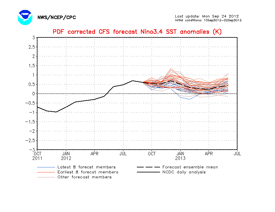
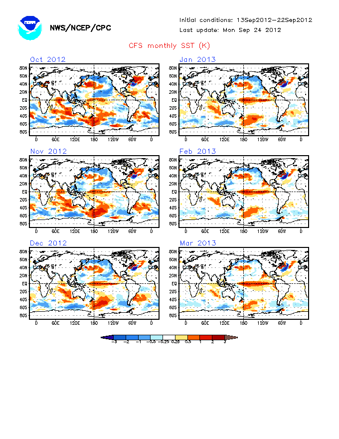
CFS virtually vanishes El Nino by early June and after that goes between cold Neutral to even La Nina threshold.


0 likes
Visit the Caribbean-Central America Weather Thread where you can find at first post web cams,radars
and observations from Caribbean basin members Click Here
and observations from Caribbean basin members Click Here
Yeah it goes weak La Nina, so both the ECM/CFS now both going cold neutral...which after an El Nino winter is the worst/best possible combination you can have for a busy season...
April and May are the key months, these are the months when the ECM/CFS really start to drop the El Nino away.
April and May are the key months, these are the months when the ECM/CFS really start to drop the El Nino away.
0 likes
Personal Forecast Disclaimer:
The posts in this forum are NOT official forecast and should not be used as such. They are just the opinion of the poster and may or may not be backed by sound meteorological data. They are NOT endorsed by any professional institution or storm2k.org. For official information, please refer to the NHC and NWS products
The posts in this forum are NOT official forecast and should not be used as such. They are just the opinion of the poster and may or may not be backed by sound meteorological data. They are NOT endorsed by any professional institution or storm2k.org. For official information, please refer to the NHC and NWS products
Who is online
Users browsing this forum: AnnularCane and 86 guests


