Atlantic Sea Surface Temperatures and Anomalies

This is the general tropical discussion area. Anyone can take their shot at predicting a storms path.

Moderator: S2k Moderators

Forum rules

The posts in this forum are NOT official forecasts and should not be used as such. They are just the opinion of the poster and may or may not be backed by sound meteorological data. They are NOT endorsed by any professional institution or STORM2K. For official information, please refer to products from the National Hurricane Center and National Weather Service.

Help Support Storm2K
Message
Author
User avatar
cycloneye
Admin
Admin
Posts: 145332
Age: 68
Joined: Thu Oct 10, 2002 10:54 am
Location: San Juan, Puerto Rico

Re: Atlantic Sea Surface Temperatures and Anomalies

#181 Postby cycloneye » Thu Mar 25, 2010 1:59 pm

Huge difference between 2009 and 2010.

March 25,2009

Image

March 24,2010

Image
0 likes   
Visit the Caribbean-Central America Weather Thread where you can find at first post web cams,radars
and observations from Caribbean basin members Click Here

User avatar
drezee
S2K Supporter
S2K Supporter
Posts: 3664
Joined: Mon Jun 09, 2003 12:49 pm
Location: FL

Re: Atlantic Sea Surface Temperatures and Anomalies

#182 Postby drezee » Thu Mar 25, 2010 7:07 pm

MDR in 2005 has caught and passed this year in some cases

Image
0 likes   

User avatar
cycloneye
Admin
Admin
Posts: 145332
Age: 68
Joined: Thu Oct 10, 2002 10:54 am
Location: San Juan, Puerto Rico

Re: Atlantic Sea Surface Temperatures and Anomalies

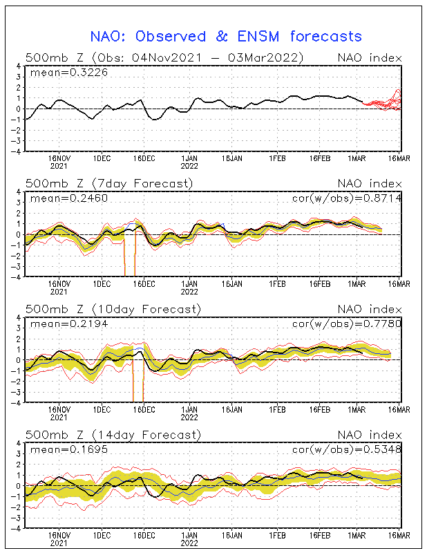
#183 Postby cycloneye » Thu Mar 25, 2010 7:31 pm

NAO (North Atlantic Occilation) will continue in negative territory for a while.

Image
0 likes   
Visit the Caribbean-Central America Weather Thread where you can find at first post web cams,radars
and observations from Caribbean basin members Click Here

User avatar
KWT
Category 5
Category 5
Posts: 31415
Joined: Tue Aug 17, 2004 11:02 am
Location: UK!!!

#184 Postby KWT » Fri Mar 26, 2010 9:56 am

While the NAO has been slightly negative in truth the synoptics across E.atlantic are very typical for the time of year with a much stronger Azores high then back this winter, however the models are suggesting some strengthening of the -ve NAO again and importantly a weakening of the Azores high, so whilst there may continue to be some weakening of the anomalies, they are still going to be warm...
0 likes   
Personal Forecast Disclaimer:
The posts in this forum are NOT official forecast and should not be used as such. They are just the opinion of the poster and may or may not be backed by sound meteorological data. They are NOT endorsed by any professional institution or storm2k.org. For official information, please refer to the NHC and NWS products

User avatar
cycloneye
Admin
Admin
Posts: 145332
Age: 68
Joined: Thu Oct 10, 2002 10:54 am
Location: San Juan, Puerto Rico

Re: Atlantic Sea Surface Temperatures and Anomalies

#185 Postby cycloneye » Mon Mar 29, 2010 6:51 am

Very impressive Tropical Atlantic.And what about that very warm anomaly off Massachussetts?

Image
0 likes   
Visit the Caribbean-Central America Weather Thread where you can find at first post web cams,radars
and observations from Caribbean basin members Click Here

User avatar
cycloneye
Admin
Admin
Posts: 145332
Age: 68
Joined: Thu Oct 10, 2002 10:54 am
Location: San Juan, Puerto Rico

Re: Atlantic Sea Surface Temperatures and Anomalies

#186 Postby cycloneye » Fri Apr 02, 2010 6:42 am

Loop current slowly transporting warmer waters into the GOM.

Image
0 likes   
Visit the Caribbean-Central America Weather Thread where you can find at first post web cams,radars
and observations from Caribbean basin members Click Here

User avatar
drezee
S2K Supporter
S2K Supporter
Posts: 3664
Joined: Mon Jun 09, 2003 12:49 pm
Location: FL

Re: Atlantic Sea Surface Temperatures and Anomalies

#187 Postby drezee » Fri Apr 02, 2010 11:33 am

Seriously....SSTs are in the slot...
Image
0 likes   

User avatar
KWT
Category 5
Category 5
Posts: 31415
Joined: Tue Aug 17, 2004 11:02 am
Location: UK!!!

#188 Postby KWT » Fri Apr 02, 2010 2:45 pm

Its amazing just how sharp the gradient between the much warmer then average waters and the cooler then average waters!
0 likes   
Personal Forecast Disclaimer:
The posts in this forum are NOT official forecast and should not be used as such. They are just the opinion of the poster and may or may not be backed by sound meteorological data. They are NOT endorsed by any professional institution or storm2k.org. For official information, please refer to the NHC and NWS products

MWatkins
S2K Supporter
S2K Supporter
Posts: 2574
Joined: Sat Oct 12, 2002 7:51 pm
Location: SE Florida
Contact:

Re: Atlantic Sea Surface Temperatures and Anomalies

#189 Postby MWatkins » Fri Apr 02, 2010 2:52 pm

The similarity to 2005, in terms of the SST anomaly distribution, is quite remarkable for this time of year. I looked to see if this comparison was made earlier in the thread (and I see that Gator did exactly that in Feb)...but I haven't seen it recently.

First, here is the full ocean view on April 1st of this year

Image

Second, here is the same view from 5 years ago (wow, 5 years already):

Image

The south Atlantic is warmer this year, and the cold area in the East Pac off of south America is much more pronounced in 2005. Obviously, the Gulf was much warmer in 2005 too, but that's going to change as we get further into spring. The heat content is still there, and warm water will feed up from the Caribbean.

But, wow, the temperature distribution in the deep tropics and throughout most of the Atlantic is very similar, except the MDR this year is warmer relative to average than 2005.

Unless something unexpected happens to reverse the trend (and it can) pressures down there should be well below normal for the next several months. The trades should be much weaker than last year (cutting down on directional shear), and as has been mentioned by others in posts before this one, there will be less relatively dry air hanging around the MDR.

Also, with temperature profiles looking like this, there is some relationship to SE Texas rainfall amounts. If I remember correctly, Dr Landsea pointed out that warm MDR years mean more rain for SE Texas that isn't from Tropical Cyclones. Either that, or it causes drought there...I can't remember which one.

MW
0 likes   
Updating on the twitter now: http://www.twitter.com/@watkinstrack

Sanibel
Category 5
Category 5
Posts: 10375
Joined: Mon Aug 30, 2004 11:06 pm
Location: Offshore SW Florida

Re: Atlantic Sea Surface Temperatures and Anomalies

#190 Postby Sanibel » Fri Apr 02, 2010 5:04 pm

That cold Gulf is keeping our temperature down by the coast here compared to the inland areas.


.
0 likes   

jinftl
Category 5
Category 5
Posts: 4312
Joined: Tue Aug 31, 2004 4:47 pm
Location: fort lauderdale, fl

Re: Atlantic Sea Surface Temperatures and Anomalies

#191 Postby jinftl » Fri Apr 02, 2010 10:00 pm

In just the last week, waters in the Gulf have finally begun to climb....and the momentum of that warming will be increasing over the next several weeks into the summer.
Last edited by jinftl on Sun Apr 04, 2010 11:37 am, edited 1 time in total.
0 likes   

User avatar
gatorcane
S2K Supporter
S2K Supporter
Posts: 23691
Age: 47
Joined: Sun Mar 13, 2005 3:54 pm
Location: Boca Raton, FL

Re: Atlantic Sea Surface Temperatures and Anomalies

#192 Postby gatorcane » Sat Apr 03, 2010 1:36 pm

MWatkins wrote:The similarity to 2005, in terms of the SST anomaly distribution, is quite remarkable for this time of year. I looked to see if this comparison was made earlier in the thread (and I see that Gator did exactly that in Feb)...but I haven't seen it recently.

First, here is the full ocean view on April 1st of this year

Image

Second, here is the same view from 5 years ago (wow, 5 years already):

Image

The south Atlantic is warmer this year, and the cold area in the East Pac off of south America is much more pronounced in 2005. Obviously, the Gulf was much warmer in 2005 too, but that's going to change as we get further into spring. The heat content is still there, and warm water will feed up from the Caribbean.

But, wow, the temperature distribution in the deep tropics and throughout most of the Atlantic is very similar, except the MDR this year is warmer relative to average than 2005.

Unless something unexpected happens to reverse the trend (and it can) pressures down there should be well below normal for the next several months. The trades should be much weaker than last year (cutting down on directional shear), and as has been mentioned by others in posts before this one, there will be less relatively dry air hanging around the MDR.

Also, with temperature profiles looking like this, there is some relationship to SE Texas rainfall amounts. If I remember correctly, Dr Landsea pointed out that warm MDR years mean more rain for SE Texas that isn't from Tropical Cyclones. Either that, or it causes drought there...I can't remember which one.

MW


HI Mr. Watkins. Yes I did notice the similarities back in February. A couple of months later and it looks like the similarities are holding. If the atmospheric conditions are as favorable this season as 2005, it could be quite active indeed. Based on some of the things you have mentioned such as the presence of light trades in the MDR and less dry air, it looks like things are pointing to a much more active season than 2009.
0 likes   

User avatar
drezee
S2K Supporter
S2K Supporter
Posts: 3664
Joined: Mon Jun 09, 2003 12:49 pm
Location: FL

Re: Atlantic Sea Surface Temperatures and Anomalies

#193 Postby drezee » Sun Apr 04, 2010 11:16 am

http://hadobs.metoffice.com/hadsst2/charts.html
Check the March Anomalies...7 points measured as the warmest ever where Atlantic storms typically form!! Where can I get the MDR anomalies? Also, the Gulf is in the 98th percentile of the coldest ever...
0 likes   

jinftl
Category 5
Category 5
Posts: 4312
Joined: Tue Aug 31, 2004 4:47 pm
Location: fort lauderdale, fl

Re: Atlantic Sea Surface Temperatures and Anomalies

#194 Postby jinftl » Sun Apr 04, 2010 11:35 am

The colder than normal Gulf temps will be quickly replaced by steadily warming water in the coming 4 to 8 weeks. Now that we have finally broken the pattern of constant cold fronts and northerly flow really cooling down the surface layer of water in the Gulf, the Gulf will warm up surprisingly quickly. The Loop Current looks primed to serve as a heat pump even now, after the winter that wouldn't end.

Just in the last 10 days, the chill has started to break on the Gulf sst....some areas warming 1-2 deg Celsius in just the last 10 days. Note what is building in coverage in the Yucatan Channel...a solid area of water in the 78-80 deg range.

Image

Image

drezee wrote:http://hadobs.metoffice.com/hadsst2/charts.html
Check the March Anomalies...7 points measured as the warmest ever where Atlantic storms typically form!! Where can I get the MDR anomalies? Also, the Gulf is in the 98th percentile of the coldest ever...
Last edited by jinftl on Sun Apr 04, 2010 11:40 am, edited 1 time in total.
0 likes   

User avatar
cycloneye
Admin
Admin
Posts: 145332
Age: 68
Joined: Thu Oct 10, 2002 10:54 am
Location: San Juan, Puerto Rico

Re: Atlantic Sea Surface Temperatures and Anomalies

#195 Postby cycloneye » Sun Apr 04, 2010 11:39 am

MDR anomalies are ridiculously warm.

Image
0 likes   
Visit the Caribbean-Central America Weather Thread where you can find at first post web cams,radars
and observations from Caribbean basin members Click Here

jinftl
Category 5
Category 5
Posts: 4312
Joined: Tue Aug 31, 2004 4:47 pm
Location: fort lauderdale, fl

Re: Atlantic Sea Surface Temperatures and Anomalies

#196 Postby jinftl » Sun Apr 04, 2010 11:41 am

Scary to see the Loop Current in the Gulf of Mexico running above normal when the surrounding areas are below normal. Does this mean we will have a supercharged Loop Current like in 2005?

cycloneye wrote:MDR anomalies are ridiculously warm.

Image
0 likes   

User avatar
drezee
S2K Supporter
S2K Supporter
Posts: 3664
Joined: Mon Jun 09, 2003 12:49 pm
Location: FL

Re: Atlantic Sea Surface Temperatures and Anomalies

#197 Postby drezee » Sun Apr 04, 2010 11:42 am

The sun angle is doing serious work in the MDR!!!

http://www.ndbc.noaa.gov/show_plot.php? ... _label=GMT
0 likes   

User avatar
KWT
Category 5
Category 5
Posts: 31415
Joined: Tue Aug 17, 2004 11:02 am
Location: UK!!!

#198 Postby KWT » Sun Apr 04, 2010 12:34 pm

Yeah a little worrying that the loop current is showing its hand again even when the SST's are well below average elsewhere.
0 likes   
Personal Forecast Disclaimer:
The posts in this forum are NOT official forecast and should not be used as such. They are just the opinion of the poster and may or may not be backed by sound meteorological data. They are NOT endorsed by any professional institution or storm2k.org. For official information, please refer to the NHC and NWS products

User avatar
cycloneye
Admin
Admin
Posts: 145332
Age: 68
Joined: Thu Oct 10, 2002 10:54 am
Location: San Juan, Puerto Rico

Re: Atlantic Sea Surface Temperatures and Anomalies

#199 Postby cycloneye » Sun Apr 04, 2010 12:34 pm

GOM 2005

Image

GOM 2010

Image
0 likes   
Visit the Caribbean-Central America Weather Thread where you can find at first post web cams,radars
and observations from Caribbean basin members Click Here

User avatar
drezee
S2K Supporter
S2K Supporter
Posts: 3664
Joined: Mon Jun 09, 2003 12:49 pm
Location: FL

Re: Atlantic Sea Surface Temperatures and Anomalies

#200 Postby drezee » Mon Apr 05, 2010 5:59 pm

Anomalies are heading West....
Image
0 likes   


Return to “Talkin' Tropics”

Who is online

Users browsing this forum: Argcane, Cpv17, Google [Bot], Google Adsense [Bot], Ian2401, lilbump3000 and 55 guests