Southern Plains weather thread -- NO WAY!!! A COLD FRONT!!!!
Moderator: S2k Moderators
Forum rules

The posts in this forum are NOT official forecast and should not be used as such. They are just the opinion of the poster and may or may not be backed by sound meteorological data. They are NOT endorsed by any professional institution or STORM2K.
-
srainhoutx

- S2K Supporter

- Posts: 6919
- Age: 68
- Joined: Sun Jan 14, 2007 11:34 am
- Location: Haywood County, NC
- Contact:
Re: Southern Plains (TX/OK) Weather Megathread - 2010
Looks like areas from just W of San Antonio to Abilene to OKC will be the firing line beginning on Friday afternoon at this time. I noticed that San Angelo, Austin/San Antonio and Ft Worth/Dallas are already mentioning the severe threat. As always, how strong of a cap we have will be the key, but I suspect Friday to be an eventful afternoon and evening for areas E of the dry line. I would not be surprised to see a Slight Risk issued by the SPC in the next couple of days.
0 likes
Carla/Alicia/Jerry(In The Eye)/Michelle/Charley/Ivan/Dennis/Katrina/Rita/Wilma/Ike/Harvey
Member: National Weather Association
Wx Infinity Forums
http://wxinfinity.com/index.php
Facebook.com/WeatherInfinity
Twitter @WeatherInfinity
Member: National Weather Association
Wx Infinity Forums
http://wxinfinity.com/index.php
Facebook.com/WeatherInfinity
Twitter @WeatherInfinity
-
srainhoutx
- S2K Supporter
- Posts: 6919
- Age: 68
- Joined: Sun Jan 14, 2007 11:34 am
- Location: Haywood County, NC
- Contact:
Re: Southern Plains (TX/OK) Weather Megathread - 2010
As expected, Good Friday may be rather stormy across TX into OK as a rather strong storm system swings in from the W. This storm system has caused heavy snow and very high winds in CA and NV and will be entering into AZ, UT, CO, and NM over the next couple of days. While capping may be an issue, the SPC suspects that moisture return will be enough as well as strong multi level shear to warrant mentioning now in the 4-8 day outlook. At this time it does appear that some Super Cell Storms will fire along the dry line in W Central TX to just S of OKC.
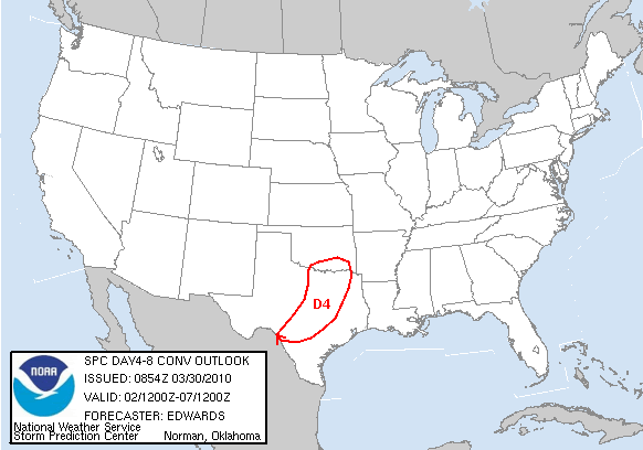
DAY 4-8 CONVECTIVE OUTLOOK
NWS STORM PREDICTION CENTER NORMAN OK
0354 AM CDT TUE MAR 30 2010
VALID 021200Z - 071200Z
...DISCUSSION...
STG WRN TROUGHING IS EXPECTED FROM WY-NM TO NWRN MEX BY START OF
DAY-4/2ND-3RD...WITH CONSENSUS AMONG BOTH ENSEMBLE AND OPERATIONAL
MODELS THAT THIS FEATURE WILL TURN NEWD LATE DAY-4 AND INTO
DAY-5/3RD-4TH...REACHING VICINITY LS BY END OF DAY-5. SFC CYCLONE
LIKEWISE SHOULD EJECT NEWD FROM SRN PLAINS TO UPPER MS VALLEY...AS
COLD FRONT SWEEPS EWD/SEWD OVER MID-UPPER MS VALLEY AND SRN PLAINS.
UKMET APPEARS TO BE LESS-RELIABLE FAST OUTLIER COMPARED TO
ECMWF/SPECTRAL AND MOST MREF MEMBERS. FRONT SHOULD WEAKEN ACROSS S
TX DAYS 5-6/3RD-5TH AS UPPER SUPPORT WILL BE WELL-REMOVED.
GREATEST SVR POTENTIAL APPEARS TO BE DAY-4 INVOF FRONT...BEGINNING
EARLY IN PERIOD OVER WRN PORTIONS SRN PLAINS...WHEN GEOMETRY OF MASS
FIELDS...MAX AVAILABILITY OF MOISTURE TO THIS SYSTEM...AND PROBABLE
ALIGNMENT OF FRONT SUGGEST LIKELIHOOD OF DOMINANT LINEAR
ORGANIZATION. DEEP-LAYER SHEAR CERTAINLY COULD BE SUFFICIENT TO
SUPPORT SUPERCELLS ESPECIALLY NEAR SRN PORTION OF CONVECTIVE ZONE
OVER TX...WHERE CAPPING WILL BE STRONGER DUE TO ANTECEDENT ELEVATED
MIXED LAYER. ACTUAL CORRIDOR OF POTENTIAL SVR THREAT IS LONGER THAN
30% AREA HERE...WHICH INSTEAD REPRESENTS BEST ESTIMATE OF
JUXTAPOSITION OF MOVING FRONTAL ZONE...RICHEST RETURNING MOISTURE
AND STG DEEP-LAYER SHEAR.
..EDWARDS.. 03/30/2010
0 likes
Carla/Alicia/Jerry(In The Eye)/Michelle/Charley/Ivan/Dennis/Katrina/Rita/Wilma/Ike/Harvey
Member: National Weather Association
Wx Infinity Forums
http://wxinfinity.com/index.php
Facebook.com/WeatherInfinity
Twitter @WeatherInfinity
Member: National Weather Association
Wx Infinity Forums
http://wxinfinity.com/index.php
Facebook.com/WeatherInfinity
Twitter @WeatherInfinity


-
mcallum177
- Tropical Depression

- Posts: 98
- Joined: Sun Jun 14, 2009 12:39 am
- Location: Dallas, TX
Re: Southern Plains (TX/OK) Weather Megathread - 2010
So with all this moisture hovering over NTX anyone think we might get to see severe storms this afternoon?
0 likes
-
somethingfunny

- ChatStaff

- Posts: 3926
- Age: 37
- Joined: Thu May 31, 2007 10:30 pm
- Location: McKinney, Texas
Re: Southern Plains (TX/OK) Weather Megathread - 2010
Good Friday was a bust and last night was a bust (had a some thundersprinkles this afternoon as the front finally cleared us) but dang it feels good outside now! 
0 likes

Re: Southern Plains (TX/OK) Weather Megathread - 2010
First organized severe weather chance day 6 on SPC website???? Its that time of year fo sho 
0 likes
-
somethingfunny
- ChatStaff
- Posts: 3926
- Age: 37
- Joined: Thu May 31, 2007 10:30 pm
- Location: McKinney, Texas
Took a drive out to the Escarpment today, around Decatur and Bridgeport, out towards Jacksboro. Man, they got some rain!!!!! Every creek and pond was completely overfilled. 48-hour totals were over six inches out that way, although today was mainly light mist. The wildflowers are EVERYWHERE though. This coming weekend will likely be absolutely incredible for Texas wildflowers!
A side note, if you're ever in Decatur, TX, there's a place on the courthouse square called Sweetie Pie's Ribeyes. They have CHICKEN FRIED RIBEYE STEAKS! yummmmmmmmmmmm
We should be drying out overnight, with our next storm system coming towards the end of this week. Hopefully, it comes on Friday this time...and even more hopefully, it'll be an organized line of storms! I can handle half an hour of horrible weather surrounded by 23 1/2 hours of perfect weather. It's these all-weekend-long washouts that I can't stand! I don't live in Seattle for a reason, this is Texas! BRING ON THE BIG HONKERS!
0 likes
-
somethingfunny
- ChatStaff
- Posts: 3926
- Age: 37
- Joined: Thu May 31, 2007 10:30 pm
- Location: McKinney, Texas
-
somethingfunny
- ChatStaff
- Posts: 3926
- Age: 37
- Joined: Thu May 31, 2007 10:30 pm
- Location: McKinney, Texas
Re: Southern Plains (TX/OK) Weather Megathread - 2010
Another front, another fizzle. But I woke up to some thunder this morning!
We'll take victories anywhere we can find them these days.
SPECIAL WEATHER STATEMENT
NATIONAL WEATHER SERVICE FORT WORTH TX
459 AM CDT SAT MAY 1 2010
TXZ119-121-133-134-145-146-011030-
DALLAS TX-KAUFMAN TX-JOHNSON TX-ELLIS TX-NAVARRO TX-HILL TX-
459 AM CDT SAT MAY 1 2010
...SIGNIFICANT WEATHER ADVISORY FOR...
SOUTHEASTERN DALLAS COUNTY
ELLIS COUNTY
HILL COUNTY
SOUTHEASTERN JOHNSON COUNTY
WESTERN KAUFMAN COUNTY
WEST CENTRAL NAVARRO COUNTY
AT 457 AM CDT...NATIONAL WEATHER SERVICE METEOROLOGISTS DETECTED A
STRONG THUNDERSTORM 6 MILES NORTHWEST OF ENNIS...MOVING NORTH AT 55
MPH. THIS STRONG THUNDERSTORM WAS EMBEDDED IN A COMPLEX OF
THUNDERSTORMS STRETCHING FROM TERRELL TO ENNIS TO HILLSBORO.
CITIES IN THE PATH OF THIS STORM INCLUDE ALMA...ALVARADO...BALCH
SPRINGS...BARDWELL...BLOOMING GROVE...BLUM...BYNUM...CARL`S CORNER...
CEDAR HILL...COMBINE...COTTONWOOD...COVINGTON...CRANDALL...DALLAS...
DESOTO...DUNCANVILLE...ENNIS...FERRIS...FORNEY...GARLAND...GLENN
HEIGHTS...GRANDVIEW...HILLSBORO...HUTCHINS...ITALY...ITASCA...
KAUFMAN...LANCASTER...MAYPEARL...MESQUITE...MIDLOTHIAN...OAK LEAF...
OVILLA...PALMER...RED OAK...SEAGOVILLE...SUNNYVALE...VENUS...
WAXAHACHIE...WHITNEY...WILMER AND CEDAR HILL STATE PARK.
FREQUENT CLOUD TO GROUND LIGHTNING...VERY HEAVY RAINFALL...PEA-SIZED
HAIL...AND WIND GUSTS TO 40 MPH CAN BE EXPECTED FROM THESE STORMS.
A SEVERE THUNDERSTORM WATCH REMAINS IN EFFECT UNTIL 900 AM CDT
SATURDAY MORNING FOR CENTRAL TEXAS.
82/JLD
We'll take victories anywhere we can find them these days.
0 likes
-
BlueIce
- S2K Supporter
- Posts: 194
- Age: 37
- Joined: Mon Sep 01, 2008 10:05 pm
- Location: Oklahoma City, Oklahoma
Re: Southern Plains (TX/OK) Weather Megathread - 2010
Could be interesting.

ON DAY 5 /MON MAY 10TH/...MODEL GUIDANCE REMAINS CONSISTENT IN THE
NEWD PROGRESSION OF AN INTENSE...NEGATIVELY-TILTED MIDLEVEL TROUGH
INTO THE CNTRL PLAINS. AN ASSOCIATED...RAPIDLY DEEPENING SURFACE
LOW OVER THE CNTRL HIGH PLAINS WILL DRAW A MOIST AIR MASS
NWD...SETTING THE STAGE FOR A POTENTIAL OUTBREAK OF SUPERCELLS
CAPABLE OF VERY LARGE HAIL AND SIGNIFICANT TORNADOES.
0 likes
-
somethingfunny
- ChatStaff
- Posts: 3926
- Age: 37
- Joined: Thu May 31, 2007 10:30 pm
- Location: McKinney, Texas
Re: Southern Plains (TX/OK) Weather Megathread - 2010
Looks like the stage is set for a MAJOR outbreak across the eastern 2/3 of Oklahoma on Monday! Watch out!
0 likes
-
mcallum177
- Tropical Depression
- Posts: 98
- Joined: Sun Jun 14, 2009 12:39 am
- Location: Dallas, TX
-
Weatherdude20*
Re: Southern Plains (TX/OK) Weather Megathread - 2010
It appears we are approaching an active storm setup for the region Wednesday night-Monday.
0 likes
-
Texas Snowman

- Storm2k Moderator

- Posts: 6197
- Joined: Fri Jan 25, 2008 11:29 am
- Location: Denison, Texas
Re: Southern Plains (TX/OK) Weather Megathread - 2010
TORNADO WATCH OUTLINE UPDATE FOR WT 155
NWS STORM PREDICTION CENTER NORMAN OK
245 PM CDT WED MAY 12 2010
Tornado watch is up in western Oklahoma and NW North Texas...
TORNADO WATCH 155 IS IN EFFECT UNTIL 1000 PM CDT FOR THE
FOLLOWING LOCATIONS
OKC003-009-011-015-017-031-033-039-043-045-047-051-053-055-057-
065-071-073-075-083-093-103-129-141-149-151-153-130300-
/O.NEW.KWNS.TO.A.0155.100512T1945Z-100513T0300Z/
OK
. OKLAHOMA COUNTIES INCLUDED ARE
ALFALFA BECKHAM BLAINE
CADDO CANADIAN COMANCHE
COTTON CUSTER DEWEY
ELLIS GARFIELD GRADY
GRANT GREER HARMON
JACKSON KAY KINGFISHER
KIOWA LOGAN MAJOR
NOBLE ROGER MILLS TILLMAN
WASHITA WOODS WOODWARD
$$
0 likes
The above post and any post by Texas Snowman is NOT an official forecast and should not be used as such. It is just the opinion of the poster and may or may not be backed by sound meteorological data. It is NOT endorsed by any professional institution including storm2k.org. For official information, please refer to NWS products.
-
somethingfunny
- ChatStaff
- Posts: 3926
- Age: 37
- Joined: Thu May 31, 2007 10:30 pm
- Location: McKinney, Texas
-
vbhoutex

- Storm2k Executive

- Posts: 29149
- Age: 74
- Joined: Wed Oct 09, 2002 11:31 pm
- Location: Cypress, TX
- Contact:
Re:
somethingfunny wrote:Rainy season cancel. Begin the hot season!!!!

We're supposed to hit the century mark in Houston this weekend too!
0 likes
Skywarn, C.E.R.T.
Please click below to donate to STORM2K to help with the expenses of keeping the site going:

Please click below to donate to STORM2K to help with the expenses of keeping the site going:
-
somethingfunny
- ChatStaff
- Posts: 3926
- Age: 37
- Joined: Thu May 31, 2007 10:30 pm
- Location: McKinney, Texas
-
vbhoutex
- Storm2k Executive
- Posts: 29149
- Age: 74
- Joined: Wed Oct 09, 2002 11:31 pm
- Location: Cypress, TX
- Contact:
Re:
somethingfunny wrote:Change of plans! Can't say I'm a little disappointed we'll have to wait a bit longer for our "baptism by fire"
Same here!! Lots of tstorms around today too. I don't expect us to get to the 90's today.
0 likes
Skywarn, C.E.R.T.
Please click below to donate to STORM2K to help with the expenses of keeping the site going:
Please click below to donate to STORM2K to help with the expenses of keeping the site going:
Return to “USA & Caribbean Weather”
Who is online
Users browsing this forum: Google [Bot], txtwister78 and 143 guests