Florida Weather

U.S. & Caribbean Weather Discussions and Severe Weather Events

Moderator: S2k Moderators

Forum rules

The posts in this forum are NOT official forecast and should not be used as such. They are just the opinion of the poster and may or may not be backed by sound meteorological data. They are NOT endorsed by any professional institution or STORM2K.

Help Support Storm2K
Message
Author
User avatar
thetruesms
Professional-Met
Professional-Met
Posts: 844
Age: 41
Joined: Thu Aug 16, 2007 1:14 pm
Location: Tallahasee, FL
Contact:

Re:

#5701 Postby thetruesms » Sun Apr 18, 2010 2:27 pm

psyclone wrote:there is a large area heavy rain headed into the Lee/Collier county region. Fire season cancel for peninsular florida at this rate. i have a lake out my window that is more typical of july... and april usually slugs it out with november for the driest month of year around these parts. it's nice to see things so green and lush and the pollen wash off is nice too.
Image Makes my job much easier

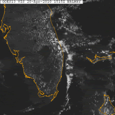
Inland Dade County is still pretty dry though, so they could still see some issues unless they start getting in on more of the heavier rain. Panhandle is in a weird spot too, because the rain after this winter has pretty much shut off - all the frost-killed fine fuels from the freezes are starting to dry out and could be a pain Image

Keetch-Byrum Drought Index kinda shows how inland Dade has been missing out lately
Image
0 likes   

User avatar
NDG
S2K Supporter
S2K Supporter
Posts: 15507
Joined: Sun Jul 09, 2006 10:14 pm
Location: Orlando, FL

Re: Florida Weather Thread: High Pressure in control

#5702 Postby NDG » Sun Apr 18, 2010 2:45 pm

SPECIAL MARINE WARNING
AMZ630-651-182030-
/O.NEW.KMFL.MA.W.0108.100418T1930Z-100418T2030Z/

BULLETIN - IMMEDIATE BROADCAST REQUESTED
SPECIAL MARINE WARNING
NATIONAL WEATHER SERVICE MIAMI FL
330 PM EDT SUN APR 18 2010

THE NATIONAL WEATHER SERVICE IN MIAMI HAS ISSUED A

* SPECIAL MARINE WARNING FOR...
COASTAL WATERS FROM DEERFIELD BEACH TO OCEAN REEF FL OUT 20 NM
BISCAYNE BAY

* UNTIL 430 PM EDT

* AT 328 PM EDT...NATIONAL WEATHER SERVICE DOPPLER RADAR INDICATED A
WATERSPOUT 10 NM SOUTH OF TURKEY POINT...ABOUT OVER BARNES SOUND...
MOVING NORTHEAST AT 5 KNOTS.

PRECAUTIONARY/PREPAREDNESS ACTIONS...

STRONG GUSTY WINDS AND INCREASING WAVES ARE LIKELY. BOATERS...
ESPECIALLY THOSE UNDER SAIL...SHOULD SEEK SAFE HARBOR IMMEDIATELY...
UNTIL CONDITIONS IMPROVE.

WATERSPOUTS CAN EASILY OVERTURN BOATS AND CREATE LOCALLY HAZARDOUS
SEAS. YOUR BEST COURSE OF EVASIVE ACTION IF THREATENED BY A
WATERSPOUT IS TO MOVE AT A 90 DEGREE ANGLE FROM ITS APPARENT
MOVEMENT. SEEK SAFE HARBOR IMMEDIATELY.

&&

LAT...LON 2526 8044 2538 8032 2541 8034 2551 8035
2556 8032 2561 8032 2567 8027 2569 8027
2564 8008 2531 8022 2534 8027 2529 8033
2525 8032 2521 8034 2519 8041
TIME...MOT...LOC 1930Z 245DEG 7KT 2523 8037
0 likes   

Sanibel
Category 5
Category 5
Posts: 10385
Joined: Mon Aug 30, 2004 11:06 pm
Location: Offshore SW Florida

Re: Florida Weather Thread: High Pressure in control

#5703 Postby Sanibel » Mon Apr 19, 2010 9:31 am

A little over an inch. The Nino winter is still pumping out rain.


Standing water in yard more like July than the height of dry season. This is unprecedented.


Refreshing cool air and hot sun combination.
0 likes   

User avatar
thetruesms
Professional-Met
Professional-Met
Posts: 844
Age: 41
Joined: Thu Aug 16, 2007 1:14 pm
Location: Tallahasee, FL
Contact:

#5704 Postby thetruesms » Mon Apr 19, 2010 9:58 am

I really wish hours 132-204 of the GFS were a lot closer, north half of the state could use a couple soakers :lol:
0 likes   

User avatar
HURAKAN
Professional-Met
Professional-Met
Posts: 46086
Age: 38
Joined: Thu May 20, 2004 4:34 pm
Location: Key West, FL
Contact:

Re: Florida Weather Thread: High Pressure in control

#5705 Postby HURAKAN » Mon Apr 19, 2010 12:00 pm

Impressive amounts of rainfall

Code: Select all

These data are preliminary and have not undergone final quality control by the National Climatic Data Center (NCDC). Therefore, these data are subject to revision. Final and certified climate data can be accessed at the NCDC - http://www.ncdc.noaa.gov.
Regional Max/Min Temp and Precipitation Table

000
ASUS62 KMFL 191422
RTPMFL
FLZ063-066>075-168-172>174-201422-
MAINLAND SOUTH FLORIDA TEMPERATURE AND PRECIPITATION TABLE
NATIONAL WEATHER SERVICE MIAMI FL
1020 AM EDT MON APR 19 2010

...HIGHEST TEMPERATURE YESTERDAY...LOWEST LAST 12 HOURS...
....PRECIPITATION LAST 24 HOURS...DATA AS OF 1200 UTC...

    AIRPORT OBSERVATIONS           HIGH         LOW         PCPN

FORT LAUDERDALE INTL      :FLL       77          68          2.80
FORT LAUDERDALE EXEC      :FXE       77          64          1.56
MIAMI INTERNATIONAL       :MIA       79          68          2.13
NAPLES MUNICIPAL AIRPORT  :APF       75          65          0.78
OPA LOCKA AIRPORT         :OPF       77          66          0.88
PEMBROKE PINES            :HWO       77          67          1.62
POMPANO BEACH AIRPORT     :PMP       77          67          2.45
WEST KENDALL/TAMIAMI AP   :TMB       79          68          0.96
WEST PALM BEACH           :PBI       79          66          0.43

 ...TEMPERATURE AND PRECIPITATION LAST 24 HOURS...

 COOPERATIVE                          REPORT
 OBSERVATIONS                          TIME     HIGH     LOW     PCPN


BIG CYPRESS               :BCIF1  MON 08:00 AM    78      62     3.27
BRIGHTON RESERVATION      :BRRF1  MON 07:00 AM    74      63     0.36
CANAL POINT               :CNLF1  MON 07:00 AM    85      64     0.12
DEVIL`S GARDEN            :DEVF1  MON 08:00 AM    79      63     1.55
FORT LAUDERDALE BEACH     :FLBF1  MON 07:00 AM    76      65     3.48
FORT LAUDERDALE DIXIE  WP :FTLF1  MON 07:00 AM    76      66     2.46
HIALEAH                   :HIAF1  MON 08:00 AM    76      66     0.96
HOLLYWOOD                 :HLWF1  MON 07:00 AM    75      65     2.15
HOMESTEAD GENERAL         :HAPF1  MON 07:00 AM    79      68     0.69
MARCO ISLAND              :MCIF1  MON 07:00 AM    76      61     0.14
MIAMI BEACH               :MIBF1  MON 08:00 AM    78      67     1.25
MOORE HAVEN               :MHVF1  MON 06:00 AM    72      65     0.92
MUSE                      :MUSF1  MON 04:30 AM    72      61     0.83
NAPLES EAST               :NPLF1  MON 05:30 AM    79      64     1.30
NORTH MIAMI BEACH         :NMBF1  MON 07:00 AM    78      66     1.16
ORTONA                    :ORTF1  MON 06:00 AM    72      62     0.97
PALM BEACH GARDENS        :PBGF1  MON 07:00 AM    77      64     0.45
PERRINE                   :PRRF1  MON 08:00 AM    77      67     0.74
SOUTH BAY 15S             :SBYF1  MON 07:00 AM    77      65     1.18
SWEETWATER NWS FIU        :MFL    MON 07:00 AM    76      66     1.28


 OTHER SOUTH FLORIDA GAGES...LAST 24 HOUR PRECIPITATION...DATA AS OF 1200 UTC


ANDYTOWN 2N S11A          :NORF1                   0.00
ANDYTOWN 5W               :ADYF1                   0.00
ANDYTOWN 18W              :ANDF1                   0.00
BOYNTON BEACH 17W         :BOYF1                   0.71
CHEKIKA EVERGLADES        :SHAF1                   0.47
COOPER CITY               :CCTF1                   2.41
COOPERTOWN 7N             :SWTF1                   0.00
COOPERTOWN 14N            :CRLF1                   0.02
CORAL SPRINGS 11W         :CSPF1                   0.00
DELRAY BEACH 8W           :DLRF1                   0.00
DELRAY BEACH 10W          :DLBF1                   0.47
DELRAY BEACH 13W          :DRBF1                   0.51
HILLSBORO CANAL           :HLLF1                   0.00
MILES CITY                :RKIF1                   1.55
MIRAMAR 17W               :MIRF1                   0.00
OASIS RANGER STATION      :OASF1                   1.39
OCHOPEE                   :OCOF1                   0.46
RACCOON POINT             :RACF1                   1.47
SWEETWATER 14NW           :SWEF1                   0.00
TAMIAMI CANAL L67         :TAMF1                   0.00
:
.END
0 likes   

User avatar
thetruesms
Professional-Met
Professional-Met
Posts: 844
Age: 41
Joined: Thu Aug 16, 2007 1:14 pm
Location: Tallahasee, FL
Contact:

#5706 Postby thetruesms » Mon Apr 19, 2010 3:24 pm

Convection growing this afternoon - that line in the Panhandle has been moving pretty slowly as it develops

Image
0 likes   

User avatar
NDG
S2K Supporter
S2K Supporter
Posts: 15507
Joined: Sun Jul 09, 2006 10:14 pm
Location: Orlando, FL

Re: Florida Weather Thread: High Pressure in control

#5707 Postby NDG » Mon Apr 19, 2010 7:24 pm

This afternoon's thunderstorms across central FL had that summertime look and feel to them, they almost looked like they were triggered by seabreeze collision & inland heating, with the help of a trough of course.
I would not doubt if because of a continuing weak El Nino it would make for an early start to the rainy summer time season, if it has not started already.
0 likes   

Patrick99
Category 5
Category 5
Posts: 1772
Joined: Mon May 24, 2004 3:43 pm
Location: SW Broward, FL

Re: Florida Weather Thread: High Pressure in control

#5708 Postby Patrick99 » Mon Apr 19, 2010 7:56 pm

Finally got in on the heavy rain in Dade last night. It really started to get going around 7PM.

That is an interesting graphic, how interior Dade has missed out on the rain while the rest of Florida is in the green. That will go away once the seabreezes start. You guys up north have been getting them, but we haven't seen any seabreeze collisions yet.
0 likes   

User avatar
thetruesms
Professional-Met
Professional-Met
Posts: 844
Age: 41
Joined: Thu Aug 16, 2007 1:14 pm
Location: Tallahasee, FL
Contact:

Re: Florida Weather Thread: High Pressure in control

#5709 Postby thetruesms » Mon Apr 19, 2010 8:03 pm

NDG wrote:This afternoon's thunderstorms across central FL had that summertime look and feel to them, they almost looked like they were triggered by seabreeze collision & inland heating, with the help of a trough of course.
I would not doubt if because of a continuing weak El Nino it would make for an early start to the rainy summer time season, if it has not started already.
Yeah, the peninsula rain were all definitely aided by convergence along the sea breezes - I took the wind barbs off the image above before uploading it because they made it kind of a mess at that size, but that made it pretty obvious.
0 likes   

User avatar
thetruesms
Professional-Met
Professional-Met
Posts: 844
Age: 41
Joined: Thu Aug 16, 2007 1:14 pm
Location: Tallahasee, FL
Contact:

#5710 Postby thetruesms » Mon Apr 19, 2010 8:06 pm

I'm a little disappointed everything fell apart with the loss of heating before reaching Tallahassee, though
0 likes   

Patrick99
Category 5
Category 5
Posts: 1772
Joined: Mon May 24, 2004 3:43 pm
Location: SW Broward, FL

Re: Florida Weather Thread: High Pressure in control

#5711 Postby Patrick99 » Mon Apr 19, 2010 8:59 pm

Looks like a new isolated t-storm over Lake O this hour, 10PM....probably outflow-boundary induced.
0 likes   

User avatar
thetruesms
Professional-Met
Professional-Met
Posts: 844
Age: 41
Joined: Thu Aug 16, 2007 1:14 pm
Location: Tallahasee, FL
Contact:

#5712 Postby thetruesms » Tue Apr 20, 2010 3:01 pm

Well well well, now doesn't this look familiar?

Image
0 likes   

JonathanBelles
Professional-Met
Professional-Met
Posts: 11430
Age: 35
Joined: Sat Dec 24, 2005 9:00 pm
Location: School: Florida State University (Tallahassee, FL) Home: St. Petersburg, Florida
Contact:

#5713 Postby JonathanBelles » Tue Apr 20, 2010 5:07 pm

Image
Image
Image
0 likes   

User avatar
thetruesms
Professional-Met
Professional-Met
Posts: 844
Age: 41
Joined: Thu Aug 16, 2007 1:14 pm
Location: Tallahasee, FL
Contact:

#5714 Postby thetruesms » Tue Apr 20, 2010 6:12 pm

Thunder been rumbling outside all afternoon, loving it!
0 likes   

User avatar
HURAKAN
Professional-Met
Professional-Met
Posts: 46086
Age: 38
Joined: Thu May 20, 2004 4:34 pm
Location: Key West, FL
Contact:

#5715 Postby HURAKAN » Tue Apr 20, 2010 6:32 pm

Image

Let it rain!
0 likes   

User avatar
HURAKAN
Professional-Met
Professional-Met
Posts: 46086
Age: 38
Joined: Thu May 20, 2004 4:34 pm
Location: Key West, FL
Contact:

#5716 Postby HURAKAN » Tue Apr 20, 2010 6:40 pm

Image

Clash of the Titans
0 likes   

Patrick99
Category 5
Category 5
Posts: 1772
Joined: Mon May 24, 2004 3:43 pm
Location: SW Broward, FL

Re: Florida Weather Thread: Taste of Summer is coming

#5717 Postby Patrick99 » Tue Apr 20, 2010 7:19 pm

Textbook seabreeze. Was watching it all day. I saw the ECSB push in relatively early, the clouds were trying to tower but the cap was too strong for anything to get going. Then as the sea breeze front passed, clearing. Saw the anvils from the inland clash, then the dying storms drifted back east and rained on me a little. Love those kind of days.
0 likes   

User avatar
gatorcane
S2K Supporter
S2K Supporter
Posts: 23703
Age: 47
Joined: Sun Mar 13, 2005 3:54 pm
Location: Boca Raton, FL

Re: Florida Weather Thread: Taste of Summer is coming

#5718 Postby gatorcane » Tue Apr 20, 2010 9:45 pm

Lots of rain here in Palm Beach County as the summer-like seabreeze-induced showers pushed E-NE from the Everglades.. a preview of summer indeed. Pretty soon instead of showers we will be seeing thunderstorms building to our west and heading east. You can usually put your clock to it everday in the afternoon around the same time, assuming we are on the SW wind pattern and not the east wind pattern where we get our showers during the night-time and early morning hours.
0 likes   

Sanibel
Category 5
Category 5
Posts: 10385
Joined: Mon Aug 30, 2004 11:06 pm
Location: Offshore SW Florida

Re: Florida Weather Thread: Taste of Summer is coming

#5719 Postby Sanibel » Wed Apr 21, 2010 2:52 pm

Because we are on the ocean side of all this we are on the dry side and sunny.
0 likes   

psyclone
S2K Supporter
S2K Supporter
Posts: 4802
Joined: Wed Aug 24, 2005 9:04 pm
Location: palm harbor fl

#5720 Postby psyclone » Sun Apr 25, 2010 4:29 pm

convection is intensifying in the eastern gulf west of the tampa bay to cedar key region as it races east. perhaps there is at least a marginal severe threat wind wise due to speedy forward motion. lots of lightning too. training potential would seem to imply at least some heavy rain potential as well. Hernando, Pasco and Pinellas (me!) appear in line for some nasty weather.
0 likes   


Return to “USA & Caribbean Weather”

Who is online

Users browsing this forum: Brent, Ntxw and 64 guests