http://www.ksn.com/content/weather/liveradar.aspx
KSN now streaming with occasional voice coverage.
Severe Weather Threat. April 21st-25th, 2010 High Risk!
Moderator: S2k Moderators
Forum rules

The posts in this forum are NOT official forecast and should not be used as such. They are just the opinion of the poster and may or may not be backed by sound meteorological data. They are NOT endorsed by any professional institution or STORM2K.
-
alan1961

- Category 2

- Posts: 771
- Joined: Mon Mar 20, 2006 11:58 am
- Location: Derby, Derbyshire, England
- Contact:
Re: Severe Weather Threat. April 21st-25th, 2010 Moderate Risk!
Bill Tabor, live chase cam, tornado on the ground, clarendon, Texas
0 likes
-
Texas Snowman

- Storm2k Moderator

- Posts: 6197
- Joined: Fri Jan 25, 2008 11:29 am
- Location: Denison, Texas
Re: Severe Weather Threat. April 21st-25th, 2010 Moderate Risk!
alan1961 wrote:Bill Tabor, live chase cam, tornado on the ground, clarendon, Texas
IN Clarendon or near Clarendon?
Makes a big difference, pretty open country in that part of the Panhandle.
0 likes
The above post and any post by Texas Snowman is NOT an official forecast and should not be used as such. It is just the opinion of the poster and may or may not be backed by sound meteorological data. It is NOT endorsed by any professional institution including storm2k.org. For official information, please refer to NWS products.
-
alan1961
- Category 2
- Posts: 771
- Joined: Mon Mar 20, 2006 11:58 am
- Location: Derby, Derbyshire, England
- Contact:
Re: Severe Weather Threat. April 21st-25th, 2010 Moderate Risk!
Texas Snowman wrote:alan1961 wrote:Bill Tabor, live chase cam, tornado on the ground, clarendon, Texas
IN Clarendon or near Clarendon?
Makes a big difference, pretty open country in that part of the Panhandle.
between clarendon and claude
0 likes
-
CrazyC83
- Professional-Met

- Posts: 34315
- Joined: Tue Mar 07, 2006 11:57 pm
- Location: Deep South, for the first time!
Re: Severe Weather Threat. April 21st-25th, 2010 Moderate Risk!
WFUS54 KAMA 222255
TORAMA
OKC007-222330-
/O.NEW.KAMA.TO.W.0008.100422T2255Z-100422T2330Z/
BULLETIN - EAS ACTIVATION REQUESTED
TORNADO WARNING
NATIONAL WEATHER SERVICE AMARILLO TX
555 PM CDT THU APR 22 2010
THE NATIONAL WEATHER SERVICE IN AMARILLO HAS ISSUED A
* TORNADO WARNING FOR...
SOUTHWESTERN BEAVER COUNTY IN THE PANHANDLE OF OKLAHOMA.
* UNTIL 630 PM CDT
* AT 551 PM CDT...TRAINED WEATHER SPOTTERS REPORTED A TORNADO NEAR
GRAY...OR ABOUT 10 MILES NORTH OF PERRYTON...MOVING NORTHEAST AT 30
MPH.
* SOME LOCATIONS NEAR THE PATH OF THIS STORM INCLUDE GRAY...
ELMWOOD...BRYANS CORNER AND BALKO.
PRECAUTIONARY/PREPAREDNESS ACTIONS...
A TORNADO HAS BEEN CONFIRMED! TAKE COVER IN A STURDY BUILDING NOW.
MOBILE HOMES AND VEHICLES ARE NOT SAFE.
TO REPORT SEVERE WEATHER...PLEASE CALL THE NATIONAL WEATHER SERVICE
AT 8 0 6 3 3 5 1 1 2 1.
&&
LAT...LON 3681 10068 3677 10032 3649 10065 3650 10094
TIME...MOT...LOC 2255Z 220DEG 27KT 3655 10074
$$
JJB
0 likes
-
CrazyC83
- Professional-Met
- Posts: 34315
- Joined: Tue Mar 07, 2006 11:57 pm
- Location: Deep South, for the first time!
Re: Severe Weather Threat. April 21st-25th, 2010 Moderate Risk!
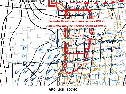
New watch could be coming farther south. No mention of replacement watch for 75 though.
MESOSCALE DISCUSSION 0340
NWS STORM PREDICTION CENTER NORMAN OK
0557 PM CDT THU APR 22 2010
AREAS AFFECTED...OK/TX PANHANDLES...FAR WRN OK...AND SWD TO WEST
CENTRAL TX
CONCERNING...TORNADO WATCH 75...
VALID 222257Z - 230000Z
THE SEVERE WEATHER THREAT FOR TORNADO WATCH 75 CONTINUES.
AN INCREASE IN MDT CU/CBS ACROSS THE TX PANHANDLE SWD THROUGH MUCH
OF W TX /VICINITY OF MAF/ SINCE 21Z IS LIKELY INDICATIVE OF STRONG
DEEP FORCING FOR ASCENT SPREADING ENEWD ACROSS THIS REGION WITHIN
EXIT REGION OF 70-85 KT SWLY MID LEVEL JET. THIS JET IS NOW MOVING
OUT OF THE BASE OF THE LARGE SWRN U.S. CLOSED LOW CENTERED OVER THE
LOWER CO RIVER VALLEY LATE THIS AFTERNOON. ENVIRONMENT ACROSS WW 75
WILL CONTINUE TO BECOME INCREASINGLY FAVORABLE FOR TORNADIC
SUPERCELLS AS EFFECTIVE BULK SHEAR INCREASES TO 50+ KT WITHIN A
CORRIDOR OF MODERATE INSTABILITY /1500-2000 J/KG/ ALONG AND E OF THE
DRY LINE.
A NEW WW MAY BE NEEDED TO THE SOUTH OF WW 75 IN THE MAF
VICINITY...AND POSSIBLY FARTHER S...WHERE REGIONAL RADARS INDICATED
AN INCREASE IN TSTM DEVELOPMENT SINCE 2145Z. THIS ACTIVITY IS
DEVELOPING WITHIN THE SRN EXTENT OF A STRENGTHENING DRY LINE BENEATH
STRONG FORCING FOR ASCENT SPREADING ENEWD INTO MUCH OF W TX AT THIS
TIME. IN ADDITION STRONG SURFACE PRESSURE FALLS OVER SW TX /AROUND
MAF/ AND AXIS EXTENDING NWD INTO TX/OK PANHANDLES WILL CONTINUE TO
AID IN BACKED S/SELY WINDS ALONG AND E OF THE DRY LINE IN RESPONSE
TO ISALLOBARIC FORCING. THESE WINDS WILL SUPPORT AN INCREASE IN LOW
LEVEL HODOGRAPH CURVATURE AND THE ATTENDANT THREAT FOR TORNADOES.
ONGOING ACTIVITY OVER DAWSON TO MIDLAND COUNTIES TX WILL TRACK NNEWD
INTO SRN EXTENT OF WW 75. IF OBSERVATIONS SUGGEST A GREATER SWD
DEVELOPMENT...THEN A NEW WW WOULD BE NEEDED.
..PETERS.. 04/22/2010
ATTN...WFO...OUN...SJT...LUB...AMA...MAF...
LAT...LON 36970200 36959920 34549924 32619994 31580075 31190160
31310210 31750217 32980214 33550212 36870209 36970200
0 likes
-
srainhoutx

- S2K Supporter

- Posts: 6919
- Age: 68
- Joined: Sun Jan 14, 2007 11:34 am
- Location: Haywood County, NC
- Contact:
Re: Severe Weather Threat. April 21st-25th, 2010 Moderate Risk!
0 likes
Carla/Alicia/Jerry(In The Eye)/Michelle/Charley/Ivan/Dennis/Katrina/Rita/Wilma/Ike/Harvey
Member: National Weather Association
Wx Infinity Forums
http://wxinfinity.com/index.php
Facebook.com/WeatherInfinity
Twitter @WeatherInfinity
Member: National Weather Association
Wx Infinity Forums
http://wxinfinity.com/index.php
Facebook.com/WeatherInfinity
Twitter @WeatherInfinity
-
CrazyC83
- Professional-Met
- Posts: 34315
- Joined: Tue Mar 07, 2006 11:57 pm
- Location: Deep South, for the first time!
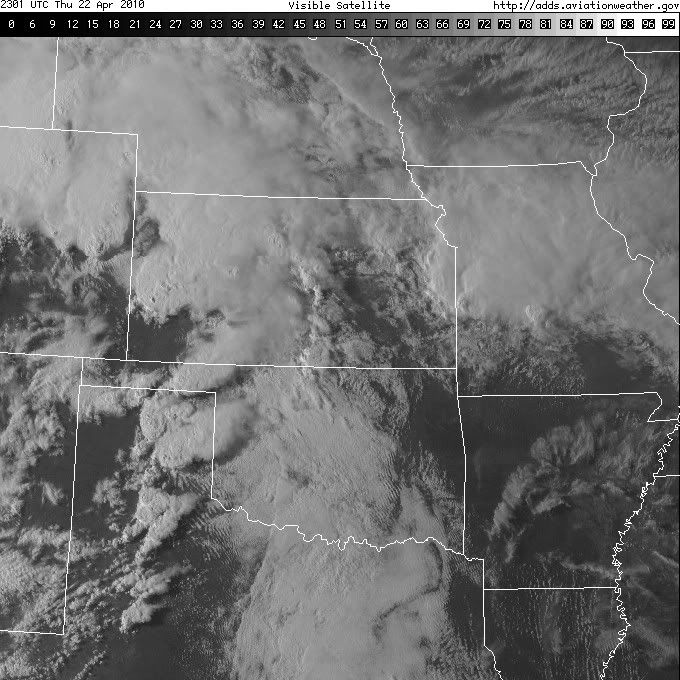
LIVE Storm chaser report: LARGE WEDGE TORNADO about twice as wide as tall, estimated location 38.26N 101.00W - 6 miles WNW of Friend, KS
http://www.severestudios.com/cgi-bin/pl ... ni&uid=157
http://www.severestudios.com/cgi-bin/pl ... ni&uid=157
0 likes
-
srainhoutx
- S2K Supporter
- Posts: 6919
- Age: 68
- Joined: Sun Jan 14, 2007 11:34 am
- Location: Haywood County, NC
- Contact:
Re: Severe Weather Threat. April 21st-25th, 2010 Moderate Risk!
0 likes
Carla/Alicia/Jerry(In The Eye)/Michelle/Charley/Ivan/Dennis/Katrina/Rita/Wilma/Ike/Harvey
Member: National Weather Association
Wx Infinity Forums
http://wxinfinity.com/index.php
Facebook.com/WeatherInfinity
Twitter @WeatherInfinity
Member: National Weather Association
Wx Infinity Forums
http://wxinfinity.com/index.php
Facebook.com/WeatherInfinity
Twitter @WeatherInfinity


-
CrazyC83
- Professional-Met
- Posts: 34315
- Joined: Tue Mar 07, 2006 11:57 pm
- Location: Deep South, for the first time!
Re:
weunice wrote:The one Steve Worthington had north of Lakin, KS lasted a few minutes and is roping out. It was spectacular for its whole life. He is getting some good shots on the ground as it ropes out. Looked to be in open country thank God.
So far all of them have been in open country, but how long can our luck last???
0 likes
Return to “USA & Caribbean Weather”
Who is online
Users browsing this forum: Cpv17 and 185 guests