Severe Weather Threat. April 21st-25th, 2010 High Risk!

U.S. & Caribbean Weather Discussions and Severe Weather Events

Moderator: S2k Moderators

Forum rules

The posts in this forum are NOT official forecast and should not be used as such. They are just the opinion of the poster and may or may not be backed by sound meteorological data. They are NOT endorsed by any professional institution or STORM2K.

Help Support Storm2K
Message
Author
User avatar
Dave
Retired Staff
Retired Staff
Posts: 13442
Age: 74
Joined: Tue Aug 01, 2006 3:57 pm
Location: Milan Indiana
Contact:

#301 Postby Dave » Sat Apr 24, 2010 8:09 am

:uarrow:

Tornado Watch Outline # 93

Image
0 likes   

User avatar
Bunkertor
Category 5
Category 5
Posts: 3397
Joined: Tue May 09, 2006 3:48 pm

#302 Postby Bunkertor » Sat Apr 24, 2010 8:14 am

079
WFUS54 KJAN 241307
TORJAN
MSC031-065-077-127-129-241415-
/O.NEW.KJAN.TO.W.0014.100424T1307Z-100424T1415Z/

BULLETIN - EAS ACTIVATION REQUESTED
TORNADO WARNING
NATIONAL WEATHER SERVICE JACKSON MS
807 AM CDT SAT APR 24 2010

THE NATIONAL WEATHER SERVICE IN JACKSON HAS ISSUED A

* TORNADO WARNING FOR...
EASTERN SIMPSON COUNTY IN CENTRAL MISSISSIPPI...
THIS INCLUDES THE CITY OF MAGEE...
SMITH COUNTY IN CENTRAL MISSISSIPPI...
NORTHWESTERN JEFFERSON DAVIS COUNTY IN SOUTH CENTRAL MISSISSIPPI...
NORTHEASTERN LAWRENCE COUNTY IN SOUTH CENTRAL MISSISSIPPI...
NORTHERN COVINGTON COUNTY IN SOUTHEAST MISSISSIPPI...

* UNTIL 915 AM CDT

* AT 808 AM CDT...NATIONAL WEATHER SERVICE METEOROLOGISTS DETECTED A
SEVERE THUNDERSTORM CAPABLE OF PRODUCING A TORNADO NEAR HEBRON
MOVING NORTHEAST AT 70 MPH.

* THE TORNADO WILL BE NEAR...
CLEM AND LONE STAR BY 815 AM CDT...
MAGEE...SANATORIUM AND MOUNT OLIVE BY 825 AM CDT...
MARTINVILLE BY 830 AM CDT...
WHITE OAK AND TAYLORSVILLE BY 835 AM CDT...
RALEIGH AND BURNS BY 840 AM CDT...

PRECAUTIONARY/PREPAREDNESS ACTIONS...
Last edited by Bunkertor on Sat Apr 24, 2010 8:15 am, edited 1 time in total.
0 likes   

User avatar
Bunkertor
Category 5
Category 5
Posts: 3397
Joined: Tue May 09, 2006 3:48 pm

#303 Postby Bunkertor » Sat Apr 24, 2010 8:14 am

958
WFUS54 KLIX 241308
TORLIX
LAC037-091-MSC005-113-241345-
/O.NEW.KLIX.TO.W.0010.100424T1308Z-100424T1345Z/

BULLETIN - EAS ACTIVATION REQUESTED
TORNADO WARNING
NATIONAL WEATHER SERVICE NEW ORLEANS LA
808 AM CDT SAT APR 24 2010

THE NATIONAL WEATHER SERVICE IN NEW ORLEANS HAS ISSUED A

* TORNADO WARNING FOR...
NORTHEASTERN EAST FELICIANA PARISH IN SOUTHEAST LOUISIANA...
THIS INCLUDES THE CITY OF CLINTON...
NORTHWESTERN ST. HELENA PARISH IN SOUTHEAST LOUISIANA...
AMITE COUNTY IN SOUTHERN MISSISSIPPI...
THIS INCLUDES THE CITY OF LIBERTY...
NORTHERN PIKE COUNTY IN SOUTHERN MISSISSIPPI...
THIS INCLUDES THE CITY OF MCCOMB...

* UNTIL 845 AM CDT

* AT 805 AM CDT...NATIONAL WEATHER SERVICE METEOROLOGISTS DETECTED A
SEVERE THUNDERSTORM CAPABLE OF PRODUCING A TORNADO NEAR CLINTON...
MOVING NORTHEAST AT 65 MPH.

* OTHER LOCATIONS IN THE WARNING INCLUDE BUT ARE NOT LIMITED TO FELPS
AND SUMMIT

PRECAUTIONARY/PREPAREDNESS ACTIONS...
0 likes   

User avatar
brunota2003
S2K Supporter
S2K Supporter
Posts: 9476
Age: 34
Joined: Sat Jul 30, 2005 9:56 pm
Location: Stanton, KY...formerly Havelock, NC
Contact:

#304 Postby brunota2003 » Sat Apr 24, 2010 8:15 am

Watch that cell just east of Fayette, AL

EDIT: to show how poor my town locating skills are, and chance MS to AL
Last edited by brunota2003 on Sat Apr 24, 2010 8:41 am, edited 1 time in total.
0 likes   

User avatar
Dave
Retired Staff
Retired Staff
Posts: 13442
Age: 74
Joined: Tue Aug 01, 2006 3:57 pm
Location: Milan Indiana
Contact:

Re:

#305 Postby Dave » Sat Apr 24, 2010 8:19 am

brunota2003 wrote:Watch that cell just east of Fayette, MS


Let's split warnings off of this thread onto one for today/night only...keep the meso & watch/info thread clear of them, otherwise with what I'm looking at on radar right now we may bury the watch info in minutes.
0 likes   

User avatar
Bunkertor
Category 5
Category 5
Posts: 3397
Joined: Tue May 09, 2006 3:48 pm

#306 Postby Bunkertor » Sat Apr 24, 2010 8:21 am

Image
0 likes   

User avatar
Dave
Retired Staff
Retired Staff
Posts: 13442
Age: 74
Joined: Tue Aug 01, 2006 3:57 pm
Location: Milan Indiana
Contact:

#307 Postby Dave » Sat Apr 24, 2010 8:27 am

0 likes   

CrazyC83
Professional-Met
Professional-Met
Posts: 34001
Joined: Tue Mar 07, 2006 11:57 pm
Location: Deep South, for the first time!

#308 Postby CrazyC83 » Sat Apr 24, 2010 8:51 am

Hearing the races at Talladega today have been postponed and the grandstands are closed. Great move for them.
0 likes   

RL3AO
Moderator-Pro Met
Moderator-Pro Met
Posts: 16308
Joined: Thu Jun 14, 2007 10:03 pm
Location: NC

Re:

#309 Postby RL3AO » Sat Apr 24, 2010 8:56 am

CrazyC83 wrote:Hearing the races at Talladega today have been postponed and the grandstands are closed. Great move for them.


Yeah. That would have been a historic disaster waiting to happen.

Although its still pretty much a massive trailer park there right now so hopefully that area can avoid strong winds.
0 likes   

CrazyC83
Professional-Met
Professional-Met
Posts: 34001
Joined: Tue Mar 07, 2006 11:57 pm
Location: Deep South, for the first time!

Re: Re:

#310 Postby CrazyC83 » Sat Apr 24, 2010 8:59 am

RL3AO wrote:
CrazyC83 wrote:Hearing the races at Talladega today have been postponed and the grandstands are closed. Great move for them.


Yeah. That would have been a historic disaster waiting to happen.

Although its still pretty much a massive trailer park there right now so hopefully that area can avoid strong winds.


They should try to get as many people out of there as possible, but not everyone is able to.
0 likes   

User avatar
Bunkertor
Category 5
Category 5
Posts: 3397
Joined: Tue May 09, 2006 3:48 pm

#311 Postby Bunkertor » Sat Apr 24, 2010 9:19 am

There must be like 150.000 viewers...
0 likes   

CrazyC83
Professional-Met
Professional-Met
Posts: 34001
Joined: Tue Mar 07, 2006 11:57 pm
Location: Deep South, for the first time!

Re: Severe Weather Threat. April 21st-25th, 2010 High Risk!

#312 Postby CrazyC83 » Sat Apr 24, 2010 9:41 am

This new watch will almost certainly be PDS as well.

MESOSCALE DISCUSSION 0372
NWS STORM PREDICTION CENTER NORMAN OK
0931 AM CDT SAT APR 24 2010

AREAS AFFECTED...MID-SOUTH AND LOWER OH VLY

CONCERNING...SEVERE POTENTIAL...TORNADO WATCH LIKELY

VALID 241431Z - 241530Z

TORNADO RISK WILL INCREASE ACROSS A LARGE PART OF THE MID-SOUTH AND
LWR OH VLY THROUGH THE AFTN. STRONG AND LONG-TRACKED TORNADOES WILL
BE POSSIBLE ALONG WITH VERY LARGE HAIL AND DMGG WIND GUSTS.


UPR AIR ANALYSIS SHOWS UPSTREAM TROUGH GOING NEGATIVE-TILT /100
METER 12-HR HEIGHT FALLS/ WITH AN EMBEDDED JET-STREAK PUNCHING ENE
INTO THE ARKLATEX REGION. THIS FEATURE WILL TRANSLATE INTO THE
MID-SOUTH/LWR OH VLY REGIONS THIS AFTN. SFC LOW OVER NCNTRL AR WILL
TRACK TO NEAR ST. LOUIS BY LATE AFTN AND UNDERGO CONSIDERABLE
DEEPENING.

MORNING STG/SVR TSTMS CLUSTERS WILL CONTINUE ENE THROUGH THE TN VLY
THROUGH EARLY THIS AFTN AND PROBABLY BECOME MORE ELEVATED WITH TIME
AS THEY MOVE TOWARD THE CUMBERLAND PLATEAU AND SRN APPALACHIAN
MOUNTAINS. SVR THREAT WILL SUBSEQUENTLY INCREASE UPSTREAM THIS
AFTN.

WARM SECTOR...CHARACTERIZED BY SFC DEW POINTS IN THE MID 60S TO LWR
70S WILL SURGE N IN WAKE OF MORNING ACTIVITY INTO ERN AR...SERN
MO...MIDDLE/WRN TN AND WRN KY AHEAD OF THE SFC LOW. THIS WILL
RESULT IN RAPID DESTABILIZATION AND SUBSEQUENT INCREASE IN TSTMS.
FCST LOW-LEVEL HODOGRAPHS WILL CONTINUE TO EXHIBIT TREMENDOUS 0-1KM
SRH VALUES 300-500+ M2/S2. THUS...ANY STORM WILL HAVE POTENTIAL FOR
STRONG...LONG-LIVED TORNADOES ALONG WITH VERY LARGE HAIL RISKS.


IT APPEARS THAT THE PRIMARY SVR EVENT MAY BE BEGINNING ACROSS
SCNTRL/SERN AR JUST AHEAD OF THE SFC LOW/WIND SHIFT. ACTIVITY
SHOULD GROW UPSCALE IN INTENSITY THROUGH THE AFTN ENE TOWARD THE
MEMPHIS/MID-SOUTH AREA AND TOWARD THE LWR OH VLY LATER THIS AFTN.

..RACY.. 04/24/2010


ATTN...WFO...LMK...OHX...BMX...HUN...PAH...MEG...JAN...LZK...

LAT...LON 33929244 35179136 37078888 37648786 37718742 37478604
36298589 35048601 33968727 32978921 32889049 33079188
33929244
0 likes   

CrazyC83
Professional-Met
Professional-Met
Posts: 34001
Joined: Tue Mar 07, 2006 11:57 pm
Location: Deep South, for the first time!

#313 Postby CrazyC83 » Sat Apr 24, 2010 9:42 am

Maybe a tornado? It was warned...

1320 UNK BANKSTON FAYETTE AL 3367 8767 TREE DOWN ON COUNTY ROAD 18E IN BANKSTON. CAR AND BUSINESS DAMAGED. (BMX)
0 likes   

User avatar
Bunkertor
Category 5
Category 5
Posts: 3397
Joined: Tue May 09, 2006 3:48 pm

#314 Postby Bunkertor » Sat Apr 24, 2010 9:43 am

That must be > 80 dbz

Image
0 likes   

CrazyC83
Professional-Met
Professional-Met
Posts: 34001
Joined: Tue Mar 07, 2006 11:57 pm
Location: Deep South, for the first time!

#315 Postby CrazyC83 » Sat Apr 24, 2010 9:53 am

Meridian MS is in serious danger now...
0 likes   

badger70
S2K Supporter
S2K Supporter
Posts: 242
Joined: Sun Mar 12, 2006 9:22 pm
Location: KSTL

Re: Severe Weather Threat. April 21st-25th, 2010 High Risk!

#316 Postby badger70 » Sat Apr 24, 2010 10:04 am

0 likes   

User avatar
Stephanie
S2K Supporter
S2K Supporter
Posts: 23843
Age: 62
Joined: Thu Feb 06, 2003 9:53 am
Location: Glassboro, NJ

Re: Severe Weather Threat. April 21st-25th, 2010 High Risk!

#317 Postby Stephanie » Sat Apr 24, 2010 10:09 am

Too early in the day for this!

That stream showed a nice hook in the storm to the south of Meridian. :eek:
0 likes   

User avatar
Dave
Retired Staff
Retired Staff
Posts: 13442
Age: 74
Joined: Tue Aug 01, 2006 3:57 pm
Location: Milan Indiana
Contact:

#318 Postby Dave » Sat Apr 24, 2010 10:10 am

Image
0 likes   

User avatar
Texas Snowman
Storm2k Moderator
Storm2k Moderator
Posts: 6151
Joined: Fri Jan 25, 2008 11:29 am
Location: Denison, Texas

Re: Severe Weather Threat. April 21st-25th, 2010 High Risk!

#319 Postby Texas Snowman » Sat Apr 24, 2010 10:11 am

That live stream said they had lost their "Sky Cam" in Meridian.

Any confirmation of a tornado hitting Meridian?

EDIT: I think I just heard the TV Met said unconfirmed reports of a tornado and possible damage in Meridian...
0 likes   
The above post and any post by Texas Snowman is NOT an official forecast and should not be used as such. It is just the opinion of the poster and may or may not be backed by sound meteorological data. It is NOT endorsed by any professional institution including storm2k.org. For official information, please refer to NWS products.

CrazyC83
Professional-Met
Professional-Met
Posts: 34001
Joined: Tue Mar 07, 2006 11:57 pm
Location: Deep South, for the first time!

Re: Severe Weather Threat. April 21st-25th, 2010 High Risk!

#320 Postby CrazyC83 » Sat Apr 24, 2010 10:15 am

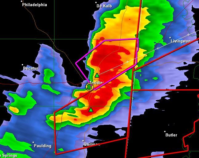
Texas Snowman wrote:That live stream said they had lost their "Sky Cam" in Meridian.

Any confirmation of a tornado hitting Meridian?

EDIT: I think I just heard the TV Met said unconfirmed reports of a tornado and possible damage in Meridian...


I'm following ABC 33-40 right now.
0 likes   


Return to “USA & Caribbean Weather”

Who is online

Users browsing this forum: South Texas Storms, wxman22 and 52 guests