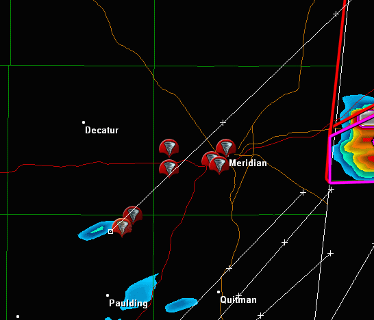
Severe Weather Threat. April 21st-25th, 2010 High Risk!

U.S. & Caribbean Weather Discussions and Severe Weather Events

Moderator: S2k Moderators

Forum rules

The posts in this forum are NOT official forecast and should not be used as such. They are just the opinion of the poster and may or may not be backed by sound meteorological data. They are NOT endorsed by any professional institution or STORM2K.

Help Support Storm2K
Message
Author
User avatar
Stephanie
S2K Supporter
S2K Supporter
Posts: 23843
Age: 62
Joined: Thu Feb 06, 2003 9:53 am
Location: Glassboro, NJ

Re: Severe Weather Threat. April 21st-25th, 2010 High Risk!

#341 Postby Stephanie » Sat Apr 24, 2010 10:41 am

Texas Snowman wrote:
badger70 wrote:Live stream ABC 33/40 out of Birmingham reporting storm shelters opening up at Talledega.


If you've ever been to a NASCAR race...or driven by a track while a race weekend is going on...then you know how dangerous this situation is.

They have closed the track and the stands will be empty.

But there are tens of thousands camping around the track in motorhomes, RV trailers, truck campers, and tents. And that many people can't be evacuated quickly. (My wife and I sat in a parking lot at Texas Motor Speedway for four hours one time without the wheels ever moving.)

If a storm were to threaten the track, there would be countless people there that would literally be "sitting ducks".


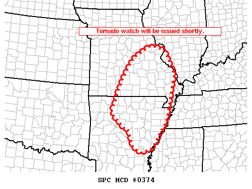
We'll just have to hope that a tornado doesn't come out of any storms that are sure to hit there.
0 likes   

User avatar
Dave
Retired Staff
Retired Staff
Posts: 13442
Age: 74
Joined: Tue Aug 01, 2006 3:57 pm
Location: Milan Indiana
Contact:

#342 Postby Dave » Sat Apr 24, 2010 10:44 am

EARLIER REPORT

TORNADO
MEEHAM MS
LAUDERDALE CTY
BROADCAST MEDIA
MAJOR STRUCTURAL DAMAGE TO A CHURCH
ON POINT WANITA ROAD. REPORTED BY WTOK
POSSIBLE TORNADO
0 likes   

User avatar
Bunkertor
Category 5
Category 5
Posts: 3397
Joined: Tue May 09, 2006 3:48 pm

#343 Postby Bunkertor » Sat Apr 24, 2010 10:50 am

:?: Ahm Dave. Sorry, i might have asked this yet some month ago, but i can´t remember.

What´s the tool to smoothen the GRLevel3 radar ?
0 likes   

User avatar
Dave
Retired Staff
Retired Staff
Posts: 13442
Age: 74
Joined: Tue Aug 01, 2006 3:57 pm
Location: Milan Indiana
Contact:

Re:

#344 Postby Dave » Sat Apr 24, 2010 10:54 am

Bunkertor wrote::?: Ahm Dave. Sorry, i might have asked this yet some month ago, but i can´t remember.

What´s the tool to smoothen the GRLevel3 radar ?


Should be a checkbox on the right side of the screen...set it to 'smooth'.
0 likes   

User avatar
Dave
Retired Staff
Retired Staff
Posts: 13442
Age: 74
Joined: Tue Aug 01, 2006 3:57 pm
Location: Milan Indiana
Contact:

#345 Postby Dave » Sat Apr 24, 2010 10:55 am

Possible tornado touchdown locations from awhile ago near Meridian MS

Image
0 likes   

CrazyC83
Professional-Met
Professional-Met
Posts: 34001
Joined: Tue Mar 07, 2006 11:57 pm
Location: Deep South, for the first time!

#346 Postby CrazyC83 » Sat Apr 24, 2010 11:02 am

Those are probably all from the same tornado and sounds like an intense one.
0 likes   

badger70
S2K Supporter
S2K Supporter
Posts: 242
Joined: Sun Mar 12, 2006 9:22 pm
Location: KSTL

Re: Severe Weather Threat. April 21st-25th, 2010 High Risk!

#347 Postby badger70 » Sat Apr 24, 2010 11:03 am

WMC-TV from Memphis is tracking the torn-warned cell west of the city.
0 likes   

User avatar
Bunkertor
Category 5
Category 5
Posts: 3397
Joined: Tue May 09, 2006 3:48 pm

Re: Re:

#348 Postby Bunkertor » Sat Apr 24, 2010 11:04 am

Dave wrote:
Bunkertor wrote::?: Ahm Dave. Sorry, i might have asked this yet some month ago, but i can´t remember.

What´s the tool to smoothen the GRLevel3 radar ?


Should be a checkbox on the right side of the screen...set it to 'smooth'.


All right, found it, but unfortunately blocked for - obviously for cheapos. I´m going to try some different things. Maybe i can manage.
Last edited by Bunkertor on Sat Apr 24, 2010 11:05 am, edited 1 time in total.
0 likes   

User avatar
Dave
Retired Staff
Retired Staff
Posts: 13442
Age: 74
Joined: Tue Aug 01, 2006 3:57 pm
Location: Milan Indiana
Contact:

#349 Postby Dave » Sat Apr 24, 2010 11:04 am

TORNADO
WARD
SUMTER COUNTY
AL
FIRE DEPT RESCUE
FIRE OFFICIALS HAVE CONFIRMED A TORNADO
TOUCHDOWN NEAR WARD. THE TORNADO WAS OBSERVERD
WITH A PATH OF TREE DAMAGE
0 likes   

Brent
S2K Supporter
S2K Supporter
Posts: 37991
Age: 36
Joined: Sun May 16, 2004 10:30 pm
Location: Tulsa Oklahoma
Contact:

Re: Severe Weather Threat. April 21st-25th, 2010 High Risk!

#350 Postby Brent » Sat Apr 24, 2010 11:10 am

AT 1101 AM CDT...LOCAL LAW ENFORCEMENT REPORTED A TORNADO. THIS
TORNADO WAS LOCATED NEAR DEMOPOLIS MUNICIPAL AIRPORT...OR 9 MILES
SOUTHWEST OF DEMOPOLIS...MOVING NORTHEAST AT 50 MPH.
0 likes   
#neversummer

CrazyC83
Professional-Met
Professional-Met
Posts: 34001
Joined: Tue Mar 07, 2006 11:57 pm
Location: Deep South, for the first time!

#351 Postby CrazyC83 » Sat Apr 24, 2010 11:13 am

I am sure there have been more tornadoes that have been reported as wind damage as well, they can be hard to see!!!
0 likes   

User avatar
Dave
Retired Staff
Retired Staff
Posts: 13442
Age: 74
Joined: Tue Aug 01, 2006 3:57 pm
Location: Milan Indiana
Contact:

#352 Postby Dave » Sat Apr 24, 2010 11:18 am

Tornado warnings are stacking on top of each other in various locations, picking them out as I go. I agree, has to be more touchdowns than I'm seeing come up from spotters/chasers.
0 likes   

User avatar
srainhoutx
S2K Supporter
S2K Supporter
Posts: 6919
Age: 67
Joined: Sun Jan 14, 2007 11:34 am
Location: Haywood County, NC
Contact:

Re: Severe Weather Threat. April 21st-25th, 2010 High Risk!

#353 Postby srainhoutx » Sat Apr 24, 2010 11:20 am

Stay safe folks. Thanks Dave for all your work. :wink: Big Outbreak. Probably the biggest since Feb 08 IMHO.
0 likes   
Carla/Alicia/Jerry(In The Eye)/Michelle/Charley/Ivan/Dennis/Katrina/Rita/Wilma/Ike/Harvey

Member: National Weather Association
Wx Infinity Forums
http://wxinfinity.com/index.php

Facebook.com/WeatherInfinity
Twitter @WeatherInfinity

User avatar
Dave
Retired Staff
Retired Staff
Posts: 13442
Age: 74
Joined: Tue Aug 01, 2006 3:57 pm
Location: Milan Indiana
Contact:

#354 Postby Dave » Sat Apr 24, 2010 11:22 am

Violent Storms Blast Miss. Valley; Heading for Southeast
UPDATED 11 AM CDT, April 24, 2010

Dangerous storms continue to blast the lower Mississippi Valley this morning, before the severe threat explodes across the Tennessee Valley into the Mid-South as the day evolves. Major storms will be capable of destructive tornadoes, gusty winds and damaging hail. Today`s severe risk is the greatest of the season so far.


Tornado Watches area already in effect from eastern Louisiana to central Tennessee and down to the Gulf Coast. This includes Jonesboro, Ark., Memphis and Nashville, Tenn., Jackson, Miss., Birmingham and Mobile, Ala., and Baton Rouge and New Orleans, La.


Severe storms will continue to erupt this morning from eastern Louisiana to eastern Arkansas and across the Deep South. These storms will sweep east into the Tennessee Valley and Southeast later today.


This is a Particularly Dangerous Situation. Strong, destructive and potentially long-lasting tornadoes, damaging hail and winds are likely from the storms, especially from northern Louisiana into eastern Arkansas, western Tennessee, much of Mississippi and Alabama. Residents should keep an eye on developing weather and be prepared to act when tornado watches and warnings are issued.


Cities like Shreveport and Baton Rouge, La., Memphis, Tenn., Jackson, Miss., and Birmingham, Ala., will see the most violent weather while severe thunderstorms are possible farther north into St. Louis, Lexington, Ky., and Cincinnati.
0 likes   

User avatar
Dave
Retired Staff
Retired Staff
Posts: 13442
Age: 74
Joined: Tue Aug 01, 2006 3:57 pm
Location: Milan Indiana
Contact:

#355 Postby Dave » Sat Apr 24, 2010 11:23 am

Image

MESOSCALE DISCUSSION 0374
NWS STORM PREDICTION CENTER NORMAN OK
1108 AM CDT SAT APR 24 2010

AREAS AFFECTED...NRN AR...SRN MO

CONCERNING...TORNADO WATCH 91...

VALID 241608Z - 241715Z

THE SEVERE WEATHER THREAT FOR TORNADO WATCH 91 CONTINUES.

A TORNADO WATCH WILL BE ISSUED SHORTLY...REPLACING WW 91.

THREAT FOR DAMAGING WINDS AND ISOLATED TORNADOES WILL INCREASE WITH
A STRONGLY FORCED QLCS LIKELY EVOLVING N/NEWD ACROSS NRN AR INTO SRN
MO THROUGH EARLY AFTERNOON.

16Z SUBJECTIVE SURFACE ANALYSIS PLACED A 997 MB CYCLONE AROUND 20 NE
LIT. ...WITH OBSERVED PRESSURE FALLS OF AROUND 2 MB/HR TO THE N/NE.
AS CYCLOGENESIS STRENGTHENS THROUGH THE AFTERNOON IN RESPONSE TO
VIGOROUS SHORT WAVE TROUGH SHIFTING NWD...INITIAL LINEAR DEVELOPMENT
OVER NRN AR WILL LIKELY EVOLVE N/NEWD...PER 12Z 4KM WRF-NMM
GUIDANCE. ALTHOUGH BOUNDARY LAYER DESTABILIZATION WILL BE LIMITED
DUE TO ABUNDANT CLOUD COVER AND AREAS OF STRATIFORM RAIN AHEAD OF
THE LINE...THE STRENGTHENING FORCING...FAST MOVEMENT OF THE
QLCS...ALONG WITH STRONG DEEP-LAYER SHEAR WILL SUPPORT A RISK FOR
DAMAGING WINDS AND ISOLATED TORNADOES.

..GRAMS.. 04/24/2010


ATTN...WFO...PAH...MEG...LSX...LZK...SGF...
0 likes   

Brent
S2K Supporter
S2K Supporter
Posts: 37991
Age: 36
Joined: Sun May 16, 2004 10:30 pm
Location: Tulsa Oklahoma
Contact:

Re: Severe Weather Threat. April 21st-25th, 2010 High Risk!

#356 Postby Brent » Sat Apr 24, 2010 11:25 am

Mississippi:

AT 1120 AM CDT...NATIONAL WEATHER SERVICE DOPPLER RADAR AND STORM
SPOTTERS WERE TRACKING A LARGE AND EXTREMELY DANGEROUS TORNADO. THIS
TORNADO WAS LOCATED NEAR INGOMAR...OR NEAR NEW ALBANY...MOVING
NORTHEAST AT 50 MPH.
0 likes   
#neversummer

User avatar
Dave
Retired Staff
Retired Staff
Posts: 13442
Age: 74
Joined: Tue Aug 01, 2006 3:57 pm
Location: Milan Indiana
Contact:

#357 Postby Dave » Sat Apr 24, 2010 11:28 am

APR 24 1202 EDT
TORNADO
THAXTON
PONTOTOC CTY
MS
LAW ENFORCEMENT
LAW ENFORCEMENT REPORTED TORNADO ON THE GROUND
NEAR THAXTON MS
0 likes   

User avatar
Dave
Retired Staff
Retired Staff
Posts: 13442
Age: 74
Joined: Tue Aug 01, 2006 3:57 pm
Location: Milan Indiana
Contact:

#358 Postby Dave » Sat Apr 24, 2010 11:34 am

Temperatures & Dew Points across KY

Current Weather Observations...
Location Time
(edt) Weather Vsby.
(SM) Temp.
(ºF) Dewpt.
(ºF) Hum.
(%) Wind
(mph) Wind
Chill (ºF) Pres.
(in)
Bowling Green 11:53 Overcast 10+(miles) 70 F(temp) 62(dew point) 76(humidity) S 15 G 23 NA 29.72
Frankfort 11:53 Fair 10+ 71 60 68 SE 10 NA 29.74
Ft. Knox 11:55 Overcast 10+ 72 63 75 S 13 NA 29.72
Huntingburg, IN 12:15 Overcast 10+ 70 63 78 SE 7 NA 29.67
Lexington 11:54 A Few Clouds 10+ 71 57 61 SE 14 G 21 NA 29.77
Lou. Bowman 11:53 A Few Clouds 10+ 71 62 73 SE 7 NA 29.72
Lou. International 11:56 Overcast 10+ 72 62 71 S 9 G 17 NA 29.71
Somerset 12:15 Partly Cloudy 10+ 73 59 61 S 14 G 20 NA 29.78
0 likes   

User avatar
Bunkertor
Category 5
Category 5
Posts: 3397
Joined: Tue May 09, 2006 3:48 pm

#359 Postby Bunkertor » Sat Apr 24, 2010 11:37 am

OK, time for the Soccer match. Stay safe folks !
0 likes   

Brent
S2K Supporter
S2K Supporter
Posts: 37991
Age: 36
Joined: Sun May 16, 2004 10:30 pm
Location: Tulsa Oklahoma
Contact:

Re: Severe Weather Threat. April 21st-25th, 2010 High Risk!

#360 Postby Brent » Sat Apr 24, 2010 11:39 am

...A TORNADO WARNING REMAINS IN EFFECT UNTIL 1145 AM CDT FOR SOUTHERN
ISSAQUENA...SOUTHWESTERN SHARKEY AND NORTHWESTERN WARREN COUNTIES...
AND NORTHEASTERN MADISON AND SOUTHEASTERN EAST CARROLL PARISHES...

AT 1129 AM CDT...NATIONAL WEATHER SERVICE METEOROLOGISTS AND STORM
SPOTTERS WERE TRACKING A LARGE AND EXTREMELY DANGEROUS TORNADO. THIS
IS A CONFIRMED LARGE TORNADO! THIS TORNADO WAS LOCATED NEAR OMEGA
MOVING NORTHEAST AT 50 MPH.
0 likes   
#neversummer


Return to “USA & Caribbean Weather”

Who is online

Users browsing this forum: 869MB, houstonkid75, Storm861 and 61 guests