Severe Weather Threat. April 21st-25th, 2010 High Risk!

U.S. & Caribbean Weather Discussions and Severe Weather Events

Moderator: S2k Moderators

Forum rules

The posts in this forum are NOT official forecast and should not be used as such. They are just the opinion of the poster and may or may not be backed by sound meteorological data. They are NOT endorsed by any professional institution or STORM2K.

Help Support Storm2K
Message
Author
User avatar
Dave
Retired Staff
Retired Staff
Posts: 13442
Age: 74
Joined: Tue Aug 01, 2006 3:57 pm
Location: Milan Indiana
Contact:

#361 Postby Dave » Sat Apr 24, 2010 11:43 am

Image

URGENT - IMMEDIATE BROADCAST REQUESTED
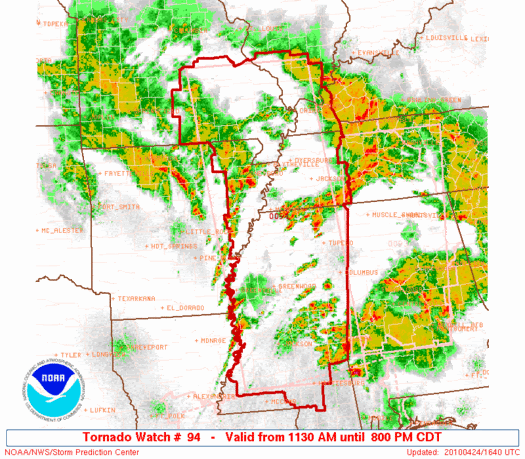
TORNADO WATCH NUMBER 94
NWS STORM PREDICTION CENTER NORMAN OK
1130 AM CDT SAT APR 24 2010

THE NWS STORM PREDICTION CENTER HAS ISSUED A
TORNADO WATCH FOR PORTIONS OF

NORTHEAST ARKANSAS
SOUTHERN ILLINOIS
PARTS OF WESTERN KENTUCKY
PARTS OF SOUTHEAST MISSOURI
MUCH OF MISSISSIPPI
WESTERN TENNESSEE

EFFECTIVE THIS SATURDAY MORNING AND EVENING FROM 1130 AM UNTIL
800 PM CDT.

...THIS IS A PARTICULARLY DANGEROUS SITUATION...

DESTRUCTIVE TORNADOES...LARGE HAIL TO 3 INCHES IN DIAMETER...
THUNDERSTORM WIND GUSTS TO 80 MPH...AND DANGEROUS LIGHTNING ARE
POSSIBLE IN THESE AREAS.


THE TORNADO WATCH AREA IS APPROXIMATELY ALONG AND 85 STATUTE
MILES EAST AND WEST OF A LINE FROM 20 MILES NORTH NORTHEAST OF
FARMINGTON MISSOURI TO 10 MILES WEST OF PINE BELT MISSISSIPPI.
FOR A COMPLETE DEPICTION OF THE WATCH SEE THE ASSOCIATED WATCH
OUTLINE UPDATE (WOUS64 KWNS WOU4).

REMEMBER...A TORNADO WATCH MEANS CONDITIONS ARE FAVORABLE FOR
TORNADOES AND SEVERE THUNDERSTORMS IN AND CLOSE TO THE WATCH
AREA. PERSONS IN THESE AREAS SHOULD BE ON THE LOOKOUT FOR
THREATENING WEATHER CONDITIONS AND LISTEN FOR LATER STATEMENTS
AND POSSIBLE WARNINGS.

OTHER WATCH INFORMATION...THIS TORNADO WATCH REPLACES TORNADO
WATCH NUMBER 91. WATCH NUMBER 91 WILL NOT BE IN EFFECT AFTER 1130
AM CDT. CONTINUE...WW 92...WW 93...

DISCUSSION...RAPID DEEPENING PROCESS OF SURFACE LOW OVER AR AS
INTENSE S/WV TROUGH ROTATES ACROSS AREA. TORNADIC SUPERCELLS
ALREADY UNDERWAY ACROSS MS AND WITH VERY STRONG WIND SHEAR PROFILES
IN PLACE CONDITIONS WILL CONTINUE AND SPREAD N AND E. IN ADDITION A
RAPIDLY MOVING SQUALL LINE MOVING ACROSS NRN AR EXPECTED TO EVOLVE
INTO A SEVERE QLCS WITH VERY STRONG/DAMAGING WINDS. EMBEDDED
TORNADIC SUPERCELLS ARE ALSO LIKELY WITH THIS FEATURE AS IT TRACKS
ACROSS MID MS VALLEY THIS AFTERNOON. DAMAGING LONG TRACK TORNADOES
ARE STILL POSSIBLE ACROSS THE WATCH.

AVIATION...TORNADOES AND A FEW SEVERE THUNDERSTORMS WITH HAIL
SURFACE AND ALOFT TO 3 INCHES. EXTREME TURBULENCE AND SURFACE
WIND GUSTS TO 70 KNOTS. A FEW CUMULONIMBI WITH MAXIMUM TOPS TO
550. MEAN STORM MOTION VECTOR 24050.


...HALES

Hazard Tornadoes EF2+ Tornadoes
Likelihood High High
Severe Wind 65 kt+ Wind
High High
Severe Hail 2"+ Hail
High Moderate
0 likes   

JonathanBelles
Professional-Met
Professional-Met
Posts: 11430
Age: 34
Joined: Sat Dec 24, 2005 9:00 pm
Location: School: Florida State University (Tallahassee, FL) Home: St. Petersburg, Florida
Contact:

#362 Postby JonathanBelles » Sat Apr 24, 2010 11:46 am

Thats the biggest high risk area I've ever seen! Stay safe out there!
0 likes   

Brent
S2K Supporter
S2K Supporter
Posts: 37991
Age: 36
Joined: Sun May 16, 2004 10:30 pm
Location: Tulsa Oklahoma
Contact:

Re: Severe Weather Threat. April 21st-25th, 2010 High Risk!

#363 Postby Brent » Sat Apr 24, 2010 12:04 pm

...THIS IS A TORNADO EMERGENCY FOR THE WARNED AREA...

AT 1155 AM CDT...NATIONAL WEATHER SERVICE METEOROLOGISTS AND STORM
SPOTTERS WERE TRACKING A LARGE AND EXTREMELY DANGEROUS WEDGE
TORNADO. SIGNIFICANT DAMAGE HAS BEEN REPORTED AT EAGLE LAKE IN
WARREN COUNTY. THIS TORNADO WAS LOCATED 8 MILES SOUTH OF HOLLY BLUFF
MOVING NORTHEAST AT 65 MPH.
0 likes   
#neversummer

User avatar
btangy
Professional-Met
Professional-Met
Posts: 758
Joined: Fri Sep 19, 2003 11:06 pm
Location: Boulder, CO
Contact:

#364 Postby btangy » Sat Apr 24, 2010 12:05 pm

Showing >120knots shear with the supercell approaching Yazoo City, MS. Likely violent and large tornado with this storm. It's in a prime area for strong, long track tornadoes right now per latest SPC/RUC mesoanalysis showing greatest amounts of energy helicity and significant tornado parameter in this region.

TORNADO EMERGENCY DECLARED Tornado nearing Yazoo City, MS.

Image
Last edited by btangy on Sat Apr 24, 2010 12:09 pm, edited 1 time in total.
0 likes   

Brent
S2K Supporter
S2K Supporter
Posts: 37991
Age: 36
Joined: Sun May 16, 2004 10:30 pm
Location: Tulsa Oklahoma
Contact:

Re: Severe Weather Threat. April 21st-25th, 2010 High Risk!

#365 Postby Brent » Sat Apr 24, 2010 12:08 pm

...THIS IS A TORNADO EMERGENCY FOR THE WARNED AREA...

AT 1203 PM CDT...NATIONAL WEATHER SERVICE METEOROLOGISTS AND STORM
SPOTTERS WERE TRACKING A LARGE AND EXTREMELY DANGEROUS WEDGE
TORNADO. THIS TORNADO WAS LOCATED 6 MILES NORTH OF SATARTIA MOVING
NORTHEAST AT 60 MPH.
0 likes   
#neversummer

CrazyC83
Professional-Met
Professional-Met
Posts: 34001
Joined: Tue Mar 07, 2006 11:57 pm
Location: Deep South, for the first time!

#366 Postby CrazyC83 » Sat Apr 24, 2010 12:11 pm

Seriously it is picking up now. By the time I get home (on an iPhone now), a wikipedia article should be warranted as well.
0 likes   

User avatar
btangy
Professional-Met
Professional-Met
Posts: 758
Joined: Fri Sep 19, 2003 11:06 pm
Location: Boulder, CO
Contact:

#367 Postby btangy » Sat Apr 24, 2010 12:12 pm

Level 2 radar data shows extreme rotation. >130 knots of horizontal shear with velocity scales maxed out. This is EF4-5 material right here.

Level 3 SVEL: Couplet approaching S side of Yazoo City.

Image
0 likes   

CrazyC83
Professional-Met
Professional-Met
Posts: 34001
Joined: Tue Mar 07, 2006 11:57 pm
Location: Deep South, for the first time!

Re:

#368 Postby CrazyC83 » Sat Apr 24, 2010 12:13 pm

btangy wrote:Showing >120knots shear with the supercell approaching Yazoo City, MS. Likely violent and large tornado with this storm. It's in a prime area for strong, long track tornadoes right now per latest SPC/RUC mesoanalysis showing greatest amounts of energy helicity and significant tornado parameter in this region.

TORNADO EMERGENCY DECLARED Tornado nearing Yazoo City, MS.

Image


Extremely dangerous situation for sure. I shudder to hear the final outcome for today...
0 likes   

snoopj
Category 2
Category 2
Posts: 530
Joined: Wed Sep 10, 2003 9:46 pm
Location: KCMO
Contact:

Re:

#369 Postby snoopj » Sat Apr 24, 2010 12:15 pm

btangy wrote:Level 2 radar data shows extreme rotation. >130 knots of horizontal shear with velocity scales maxed out. This is EF4-5 material right here.


I agree. Granted I tend to use the NROT value off the Level 2 data, but you've got a NROT value of 3.46 being detected on the last scan. For reference, Greensburg was 3.8-4.6 (although a much wider field) when it got hit. Enterprise, AL back a few years was about 2.8 and that was EF-4 as well.

Rough estimation using something that I believe is still pretty experimental (or was the last time I looked).

And it's heading right into a town. Ugh.
0 likes   

Brent
S2K Supporter
S2K Supporter
Posts: 37991
Age: 36
Joined: Sun May 16, 2004 10:30 pm
Location: Tulsa Oklahoma
Contact:

Re: Severe Weather Threat. April 21st-25th, 2010 High Risk!

#370 Postby Brent » Sat Apr 24, 2010 12:17 pm

* AT 1211 PM CDT...NATIONAL WEATHER SERVICE METEOROLOGISTS AND STORM
SPOTTERS WERE TRACKING A LARGE AND EXTREMELY DANGEROUS WEDGE
TORNADO 17MILES WEST OF MIDWAY MOVING NORTHEAST AT 50 MPH.
0 likes   
#neversummer

CrazyC83
Professional-Met
Professional-Met
Posts: 34001
Joined: Tue Mar 07, 2006 11:57 pm
Location: Deep South, for the first time!

#371 Postby CrazyC83 » Sat Apr 24, 2010 12:18 pm

I hate to say but I would be shocked if no one is killed in Yazoo City.
0 likes   

User avatar
btangy
Professional-Met
Professional-Met
Posts: 758
Joined: Fri Sep 19, 2003 11:06 pm
Location: Boulder, CO
Contact:

#372 Postby btangy » Sat Apr 24, 2010 12:20 pm

Population of the town is 14,841 (as of 2007). Looks like the strongest velocities tracked S and right over the town. My guess is it was a very large tornado, but will need ground confirmation. I fear the worst though.
Last edited by btangy on Sat Apr 24, 2010 12:25 pm, edited 2 times in total.
0 likes   

User avatar
srainhoutx
S2K Supporter
S2K Supporter
Posts: 6919
Age: 67
Joined: Sun Jan 14, 2007 11:34 am
Location: Haywood County, NC
Contact:

Re: Severe Weather Threat. April 21st-25th, 2010 High Risk!

#373 Postby srainhoutx » Sat Apr 24, 2010 12:20 pm

Seeing some 197 kt GTG with the Yazoo City, MS system.
0 likes   
Carla/Alicia/Jerry(In The Eye)/Michelle/Charley/Ivan/Dennis/Katrina/Rita/Wilma/Ike/Harvey

Member: National Weather Association
Wx Infinity Forums
http://wxinfinity.com/index.php

Facebook.com/WeatherInfinity
Twitter @WeatherInfinity

User avatar
KatDaddy
Category 5
Category 5
Posts: 2815
Joined: Mon Oct 21, 2002 6:23 pm
Location: League City, Texas

#374 Postby KatDaddy » Sat Apr 24, 2010 12:21 pm

Amazing event unfolding today and the outcome will not be a good one. Some very strong wording from several of the NWS sites. Large tornadoes on the ground as I type.
0 likes   
The following post is NOT an official forecast and should not be used as such. It is just the opinion of the poster and may or may not be backed by sound meteorological data. It is NOT endorsed by any professional institution including storm2k.org For Official Information please refer to the NHC and NWS products.

User avatar
KatDaddy
Category 5
Category 5
Posts: 2815
Joined: Mon Oct 21, 2002 6:23 pm
Location: League City, Texas

#375 Postby KatDaddy » Sat Apr 24, 2010 12:22 pm

197Kts! I too fear the worst for Yazoo City. There will no doubt be loss of life. Terrible.
0 likes   
The following post is NOT an official forecast and should not be used as such. It is just the opinion of the poster and may or may not be backed by sound meteorological data. It is NOT endorsed by any professional institution including storm2k.org For Official Information please refer to the NHC and NWS products.

User avatar
btangy
Professional-Met
Professional-Met
Posts: 758
Joined: Fri Sep 19, 2003 11:06 pm
Location: Boulder, CO
Contact:

Re: Severe Weather Threat. April 21st-25th, 2010 High Risk!

#376 Postby btangy » Sat Apr 24, 2010 12:25 pm

Supercell that just hit Yazoo City, MS continues to track into an environment with CAPE >2500, 0-1km Helicity of >600, and EHI of >10. The latter two numbers are off the charts. Expect to see this supercell continue to cycle with long track, violent tornadoes.
0 likes   

User avatar
srainhoutx
S2K Supporter
S2K Supporter
Posts: 6919
Age: 67
Joined: Sun Jan 14, 2007 11:34 am
Location: Haywood County, NC
Contact:

Re: Severe Weather Threat. April 21st-25th, 2010 High Risk!

#377 Postby srainhoutx » Sat Apr 24, 2010 12:28 pm

PRELIMINARY LOCAL STORM REPORT
NATIONAL WEATHER SERVICE JACKSON MS
1223 PM CDT SAT APR 24 2010

..TIME... ...EVENT... ...CITY LOCATION... ...LAT.LON...
..DATE... ....MAG.... ..COUNTY LOCATION..ST.. ...SOURCE....
..REMARKS..

1220 PM TORNADO 1 S YAZOO CITY 32.85N 90.41W
04/24/2010 YAZOO MS AMATEUR RADIO

CHURCH DESTROYED AT CORNER OF HIGHWAY 16 AND HIGHWAY 49.
NUMEROUS TREES AND POWER LINES DOWN ALSO.
0 likes   
Carla/Alicia/Jerry(In The Eye)/Michelle/Charley/Ivan/Dennis/Katrina/Rita/Wilma/Ike/Harvey

Member: National Weather Association
Wx Infinity Forums
http://wxinfinity.com/index.php

Facebook.com/WeatherInfinity
Twitter @WeatherInfinity

User avatar
btangy
Professional-Met
Professional-Met
Posts: 758
Joined: Fri Sep 19, 2003 11:06 pm
Location: Boulder, CO
Contact:

#378 Postby btangy » Sat Apr 24, 2010 12:29 pm

The reflectivities around the hook echo increased pretty dramatically after passing over Yazoo City indicative of possible debris cloud in the air.
0 likes   

User avatar
srainhoutx
S2K Supporter
S2K Supporter
Posts: 6919
Age: 67
Joined: Sun Jan 14, 2007 11:34 am
Location: Haywood County, NC
Contact:

Re:

#379 Postby srainhoutx » Sat Apr 24, 2010 12:31 pm

btangy wrote:The reflectivities around the hook echo increased pretty dramatically after passing over Yazoo City indicative of possible debris cloud in the air.


Seeing many reports of a debris ball. Truly sad.
0 likes   
Carla/Alicia/Jerry(In The Eye)/Michelle/Charley/Ivan/Dennis/Katrina/Rita/Wilma/Ike/Harvey

Member: National Weather Association
Wx Infinity Forums
http://wxinfinity.com/index.php

Facebook.com/WeatherInfinity
Twitter @WeatherInfinity

User avatar
Bunkertor
Category 5
Category 5
Posts: 3397
Joined: Tue May 09, 2006 3:48 pm

#380 Postby Bunkertor » Sat Apr 24, 2010 12:40 pm

:eek: :eek: :eek: :eek: :eek: Cahser Alton Webb is in Yazoo :eek: :eek: :eek: :eek: :eek:
0 likes   


Return to “USA & Caribbean Weather”

Who is online

Users browsing this forum: Brent, TomballEd and 57 guests