...THIS IS A TORNADO EMERGENCY FOR THE WARNED AREA...
AT 1236 PM CDT...NATIONAL WEATHER SERVICE METEOROLOGISTS AND STORM
SPOTTERS WERE TRACKING A LARGE AND EXTREMELY DANGEROUS WEDGE
TORNADO. SIGNIFICANT DAMAGE HAS OCCURRED IN YAZOO CITY WITH MULTIPLE
INJURIES! THIS TORNADO WAS LOCATED NEAR EBENEZER MOVING NORTHEAST
AT 55 MPH.
Severe Weather Threat. April 21st-25th, 2010 High Risk!
Moderator: S2k Moderators
Forum rules

The posts in this forum are NOT official forecast and should not be used as such. They are just the opinion of the poster and may or may not be backed by sound meteorological data. They are NOT endorsed by any professional institution or STORM2K.


-
srainhoutx

- S2K Supporter

- Posts: 6919
- Age: 68
- Joined: Sun Jan 14, 2007 11:34 am
- Location: Haywood County, NC
- Contact:
Re: Severe Weather Threat. April 21st-25th, 2010 High Risk!
Appears to be cycling again. Seeing some 150+ kt GTG. btangy was spot on. Looks like a long tracker.
0 likes
Carla/Alicia/Jerry(In The Eye)/Michelle/Charley/Ivan/Dennis/Katrina/Rita/Wilma/Ike/Harvey
Member: National Weather Association
Wx Infinity Forums
http://wxinfinity.com/index.php
Facebook.com/WeatherInfinity
Twitter @WeatherInfinity
Member: National Weather Association
Wx Infinity Forums
http://wxinfinity.com/index.php
Facebook.com/WeatherInfinity
Twitter @WeatherInfinity


Re: Severe Weather Threat. April 21st-25th, 2010 High Risk!
Tornado signature on radar crossing I-55. City of Durant (pop: 2,720) is threatened. Tornado Emergency remains in effect.

0 likes
-
srainhoutx
- S2K Supporter
- Posts: 6919
- Age: 68
- Joined: Sun Jan 14, 2007 11:34 am
- Location: Haywood County, NC
- Contact:
Re: Severe Weather Threat. April 21st-25th, 2010 High Risk!
Appears as that this tornado has been on the ground for about 90 miles if my calculations are correct.
0 likes
Carla/Alicia/Jerry(In The Eye)/Michelle/Charley/Ivan/Dennis/Katrina/Rita/Wilma/Ike/Harvey
Member: National Weather Association
Wx Infinity Forums
http://wxinfinity.com/index.php
Facebook.com/WeatherInfinity
Twitter @WeatherInfinity
Member: National Weather Association
Wx Infinity Forums
http://wxinfinity.com/index.php
Facebook.com/WeatherInfinity
Twitter @WeatherInfinity

Gotta back away for a bit. To have such perfect weather while others are loosing everything is just not fair. This is a sad day indeed.
0 likes
The following post is NOT an official forecast and should not be used as such. It is just the opinion of the poster and may or may not be backed by sound meteorological data. It is NOT endorsed by any professional institution including storm2k.org For Official Information please refer to the NHC and NWS products.
-
srainhoutx
- S2K Supporter
- Posts: 6919
- Age: 68
- Joined: Sun Jan 14, 2007 11:34 am
- Location: Haywood County, NC
- Contact:
Re:
KatDaddy wrote:Gotta back away for a bit. To have such perfect weather while others are loosing everything is just not fair. This is a sad day indeed.
I agree KatDaddy. Just sickening.
PRELIMINARY LOCAL STORM REPORT
NATIONAL WEATHER SERVICE JACKSON MS
1245 PM CDT SAT APR 24 2010
..TIME... ...EVENT... ...CITY LOCATION... ...LAT.LON...
..DATE... ....MAG.... ..COUNTY LOCATION..ST.. ...SOURCE....
..REMARKS..
1225 PM TORNADO YAZOO CITY 32.86N 90.41W
04/24/2010 YAZOO MS STORM CHASER
NUMEROUS HOMES AND BUSINESSES DAMAGED ALONG WITH
WIDESPREAD TREES DOWN IN CITY LIMITS.
0 likes
Carla/Alicia/Jerry(In The Eye)/Michelle/Charley/Ivan/Dennis/Katrina/Rita/Wilma/Ike/Harvey
Member: National Weather Association
Wx Infinity Forums
http://wxinfinity.com/index.php
Facebook.com/WeatherInfinity
Twitter @WeatherInfinity
Member: National Weather Association
Wx Infinity Forums
http://wxinfinity.com/index.php
Facebook.com/WeatherInfinity
Twitter @WeatherInfinity
Re: Severe Weather Threat. April 21st-25th, 2010 High Risk!
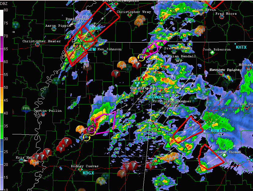
N MS just S of Booneville.. also a pretty strong couplet evident on radar.

at 1257 PM CDT... National Weather Service Doppler radar was
tracking a large and extremely dangerous tornado 10 miles west of
Burton... or near Booneville... moving northeast at 50 mph.
0 likes
-
srainhoutx
- S2K Supporter
- Posts: 6919
- Age: 68
- Joined: Sun Jan 14, 2007 11:34 am
- Location: Haywood County, NC
- Contact:
Re: Severe Weather Threat. April 21st-25th, 2010 High Risk!
btangy, if you have a chance it appears that we have another vortex hole showing up on the longer tracker.
0 likes
Carla/Alicia/Jerry(In The Eye)/Michelle/Charley/Ivan/Dennis/Katrina/Rita/Wilma/Ike/Harvey
Member: National Weather Association
Wx Infinity Forums
http://wxinfinity.com/index.php
Facebook.com/WeatherInfinity
Twitter @WeatherInfinity
Member: National Weather Association
Wx Infinity Forums
http://wxinfinity.com/index.php
Facebook.com/WeatherInfinity
Twitter @WeatherInfinity
-
Dave

- Retired Staff

- Posts: 13442
- Age: 75
- Joined: Tue Aug 01, 2006 3:57 pm
- Location: Milan Indiana
- Contact:
Damage reports from SW of Yazoo city to the city itself...
APR 24 121400 EDT
TORNADO
4 MI NW TALLUAH
MADISON CTY
LA
LAW ENFORCEMENT
PRELIMARY REPORTS OF SIGNIFICANT DAMAGE FROM
MADISON PARISH WITH HOMES DESTROYED. LARGE
TORNADO WAS VISUALLY SIGHTED
=========================
APR 24 122300 EDT
TORNADO
OMEGA
MADISON CTY
LA
EMERGENCY MGR
TORNADO REPORTEDLY CAUSED SIGNIFICANT
DAMAGE TO AN INDUSTRIAL PLANT. ** INJURIES
REPORTED WITH PEOPLE TRAPPED
=========================
APR 24 125500 EDT
TORNADO
1 MI N EAGLE BEND
WARREN CTY
MS
LAW ENFORCEMENT
30 HOUSES FLATTENED REPORTED BY 911
=========================
APR 24 124100 EDT
TORNADO
1 MI S VALLEY PARK
ISSAQUENA
MS
STORM CHASER
STORM CHASER REPORTS LARGE WEDGE
TORNADO CROSSING HIGHWAY 61 NEAR VALLEY
PARK
========================
APR 24 131000 EDT
TORNADO
3 MI N SATARTIA
YAZOO CTY
MS
PUBLIC
HOME DESTROYED 3 MILES NORTH OF SATARTIA.
PEOPLE TRAPPED INSIDE.
========================
APR 24 131600 EDT
TORNADO
6 MI SW YAZOO CITY
MS
TRAINED SPOTTER
WIDESPREAD TREES DOWN WITH HOMES DAMAGED IN TOWN
OF CRUPP
=======================
APR 24 132000 EDT
TORNADO
1 MI S YAZOO CITY
YAZOO CTY
MS
AMATEUR RADIO
CHURCH DESTROYED AT CORNER OF HIGHWAY 16
AND HIGHWAY 49. NUMEROUS TREES AND POWER LINES DOWN.
=======================
APR 24 131600 EDT
TORNADO
2 MI E YAZOO CITY
YAZOO CTY
MS
AMATEUR RADIO
STRUCTURES DESTROYED AT HWY 16 AND OLD BENTON RD
0 likes
-
srainhoutx
- S2K Supporter
- Posts: 6919
- Age: 68
- Joined: Sun Jan 14, 2007 11:34 am
- Location: Haywood County, NC
- Contact:
Re: Severe Weather Threat. April 21st-25th, 2010 High Risk!
The Yazoo City tornado may pass near Starkville (home of MSU).
0 likes
Carla/Alicia/Jerry(In The Eye)/Michelle/Charley/Ivan/Dennis/Katrina/Rita/Wilma/Ike/Harvey
Member: National Weather Association
Wx Infinity Forums
http://wxinfinity.com/index.php
Facebook.com/WeatherInfinity
Twitter @WeatherInfinity
Member: National Weather Association
Wx Infinity Forums
http://wxinfinity.com/index.php
Facebook.com/WeatherInfinity
Twitter @WeatherInfinity

Re: Severe Weather Threat. April 21st-25th, 2010 High Risk!
PRELIMINARY LOCAL STORM REPORT
NATIONAL WEATHER SERVICE JACKSON MS
112 PM CDT SAT APR 24 2010
..TIME... ...EVENT... ...CITY LOCATION... ...LAT.LON...
..DATE... ....MAG.... ..COUNTY LOCATION..ST.. ...SOURCE....
..REMARKS..
1250 PM TORNADO 1 W DURANT 33.08N 89.87W
04/24/2010 HOLMES MS EMERGENCY MNGR
*** 1 INJ *** MULITPLE CARS BLOWN OFF INTERSTATE 55.
UNKNOWN NUMBER OF INJURIES. REPORT RELAYED VIA ATTALA
COUNTY EMA.
0 likes
-
Dave
- Retired Staff
- Posts: 13442
- Age: 75
- Joined: Tue Aug 01, 2006 3:57 pm
- Location: Milan Indiana
- Contact:
Re: Severe Weather Threat. April 21st-25th, 2010 High Risk!
srainhoutx wrote:The Yazoo City tornado may pass near Starkville (home of MSU).
staying on yazoo city tornado
CARROLL MS-MONTGOMERY MS-CHOCTAW MS-ATTALA MS-
117 PM CDT SAT APR 24 2010
...A TORNADO WARNING REMAINS IN EFFECT UNTIL 145 PM CDT FOR
NORTHEASTERN ATTALA...WESTERN CHOCTAW...SOUTHEASTERN MONTGOMERY AND
EXTREME SOUTHEASTERN CARROLL COUNTIES...
AT 117 PM CDT...NATIONAL WEATHER SERVICE METEOROLOGISTS CONTINUED TO
TRACK A TORNADO. THIS TORNADO WAS LOCATED NEAR HESTERVILLE MOVING
NORTHEAST AT 55 MPH.
THE TORNADO WILL BE NEAR...
FRENCH CAMP BY 125 PM CDT...
WEIR AND MCCOOL BY 130 PM CDT...
CHESTER BY 140 PM CDT...
0 likes
The supercell is entering the most favorable region for maximum updraft helicity so I expect it continue cycling until it crosses US 82... could pass close to Starkville, MS on its current trajectory. Rotation remains strong, but not as strong as it was earlier when it passed over Yazoo City, MS. Also have to take into account that it's moving away from the radar and we're only seeing the midlevel mesocyclone now on radar, so it's hard to get a sense of what's really happening where it counts.

Last edited by btangy on Sat Apr 24, 2010 1:23 pm, edited 1 time in total.
0 likes
-
Dave
- Retired Staff
- Posts: 13442
- Age: 75
- Joined: Tue Aug 01, 2006 3:57 pm
- Location: Milan Indiana
- Contact:
APR 24 135500 EDT
TORNADO
1 MI S DURANT
HOLMES CTY
MS
PUBLIC
NUMEROUS TREES DOWN BLOCKING HWY 51.
SHEDS HEAVILY DAMAGED. MINOR DAMAGE TO HOMES.
===============
APR 24 135500 EDT
TORNADO
2 MI E DURANT
ATTALA CTY
MS
EMERGENCY MGR
NUMEROUS TREES DOWN AND STRUCTURES DAMAGED
ON CTY ROAD 4101 ON EITHER SIDE OF HWY 12
TORNADO
1 MI S DURANT
HOLMES CTY
MS
PUBLIC
NUMEROUS TREES DOWN BLOCKING HWY 51.
SHEDS HEAVILY DAMAGED. MINOR DAMAGE TO HOMES.
===============
APR 24 135500 EDT
TORNADO
2 MI E DURANT
ATTALA CTY
MS
EMERGENCY MGR
NUMEROUS TREES DOWN AND STRUCTURES DAMAGED
ON CTY ROAD 4101 ON EITHER SIDE OF HWY 12
0 likes
-
srainhoutx
- S2K Supporter
- Posts: 6919
- Age: 68
- Joined: Sun Jan 14, 2007 11:34 am
- Location: Haywood County, NC
- Contact:
Re: Severe Weather Threat. April 21st-25th, 2010 High Risk!
URGENT - IMMEDIATE BROADCAST REQUESTED
TORNADO WATCH NUMBER 96
NWS STORM PREDICTION CENTER NORMAN OK
120 PM CDT SAT APR 24 2010
THE NWS STORM PREDICTION CENTER HAS ISSUED A
TORNADO WATCH FOR PORTIONS OF
MUCH OF ALABAMA
PARTS OF SOUTHEAST ILLINOIS
PARTS OF INDIANA
LARGE PART OF WESTERN AND CENTRAL KENTUCKY
MIDDLE TENNESSEE
EFFECTIVE THIS SATURDAY AFTERNOON AND EVENING FROM 120 PM UNTIL
900 PM CDT.
...THIS IS A PARTICULARLY DANGEROUS SITUATION...
NUMEROUS TORNADOES
INTENSE TORNADOES LIKELY
WIDESPREAD DAMAGING WINDS
WIND GUSTS TO 80 MPH LIKELY
WIDESPREAD LARGE HAIL
HAIL TO 3.0 INCHES IN DIAMETER LIKELY
THE TORNADO WATCH AREA IS APPROXIMATELY ALONG AND 75 STATUTE
MILES EAST AND WEST OF A LINE FROM 25 MILES SOUTH SOUTHWEST OF
MONTGOMERY ALABAMA TO 40 MILES NORTHEAST OF EVANSVILLE INDIANA.
FOR A COMPLETE DEPICTION OF THE WATCH SEE THE ASSOCIATED WATCH
OUTLINE UPDATE (WOUS64 KWNS WOU6).
REMEMBER...A TORNADO WATCH MEANS CONDITIONS ARE FAVORABLE FOR
TORNADOES AND SEVERE THUNDERSTORMS IN AND CLOSE TO THE WATCH
AREA. PERSONS IN THESE AREAS SHOULD BE ON THE LOOKOUT FOR
THREATENING WEATHER CONDITIONS AND LISTEN FOR LATER STATEMENTS
AND POSSIBLE WARNINGS.
OTHER WATCH INFORMATION...THIS TORNADO WATCH REPLACES TORNADO
WATCH NUMBER 93. WATCH NUMBER 93 WILL NOT BE IN EFFECT AFTER 120
PM CDT. CONTINUE...WW 94...WW 95...
DISCUSSION...SEVERE THUNDERSTORMS CONTINUE TO INCREASE IN BOTH
NUMBER AND INTENSITY AHEAD OF THE RAPIDLY DEEPENING LOW AND UPPER
TROUGH MOVING TOWARD THE MID MISSISSIPPI VALLEY. VERY STRONG DEEP
LAYER SHEAR COUPLED WITH VERY MOIST/UNSTABLE AIR MASS CONTINUES TO
SUPPORT BOTH TORNADIC SUPERCELLS AND VERY DAMAGING WINDS. THREAT
WILL RAPIDLY SPREAD NORTH AND EAST ACROSS THE WATCH THRU THE
AFTERNOON. THE RISK FOR LARGE LONG TRACK TORNADOES WILL BE A THREAT
AS WELL.
0 likes
Carla/Alicia/Jerry(In The Eye)/Michelle/Charley/Ivan/Dennis/Katrina/Rita/Wilma/Ike/Harvey
Member: National Weather Association
Wx Infinity Forums
http://wxinfinity.com/index.php
Facebook.com/WeatherInfinity
Twitter @WeatherInfinity
Member: National Weather Association
Wx Infinity Forums
http://wxinfinity.com/index.php
Facebook.com/WeatherInfinity
Twitter @WeatherInfinity
Return to “USA & Caribbean Weather”
Who is online
Users browsing this forum: Google Adsense [Bot] and 206 guests