Severe Weather Threat. April 21st-25th, 2010 High Risk!

U.S. & Caribbean Weather Discussions and Severe Weather Events

Moderator: S2k Moderators

Forum rules

The posts in this forum are NOT official forecast and should not be used as such. They are just the opinion of the poster and may or may not be backed by sound meteorological data. They are NOT endorsed by any professional institution or STORM2K.

Help Support Storm2K
Message
Author
User avatar
brunota2003
S2K Supporter
S2K Supporter
Posts: 9476
Age: 34
Joined: Sat Jul 30, 2005 9:56 pm
Location: Stanton, KY...formerly Havelock, NC
Contact:

Re: Severe Weather Threat. April 21st-25th, 2010 High Risk!

#401 Postby brunota2003 » Sat Apr 24, 2010 1:28 pm

Here are a couple images from GrLevel2 Analyst I took of the Yazoo storm (both images are after the supercell passed through the town), the first is a side profile of the Supercell, and the second is the clearly visible debris ball (both are the storm as the radar sees it).

Side profile (from the Base Reflectivity), as the radar sees the storm. Note the overshooting top indicating where the strongest portion of the updraft is (since you can see the anvil), along with the flanking line coming into the supercell. The view is from the east I believe, with the cell moving from left to right (to the NE)
Image


This next image is of the Base Reflectivity of the storm, with the lightest precip colors knocked off (the blues, yellows, greens, etc) and the oranges/reds subdued so you can see them, along with any purples. Note the clearly evident debris field from the circulation of the tornado.
Image
0 likes   

User avatar
Dave
Retired Staff
Retired Staff
Posts: 13442
Age: 74
Joined: Tue Aug 01, 2006 3:57 pm
Location: Milan Indiana
Contact:

#402 Postby Dave » Sat Apr 24, 2010 1:30 pm

:uarrow:
Image
0 likes   

User avatar
srainhoutx
S2K Supporter
S2K Supporter
Posts: 6919
Age: 67
Joined: Sun Jan 14, 2007 11:34 am
Location: Haywood County, NC
Contact:

Re: Severe Weather Threat. April 21st-25th, 2010 High Risk!

#403 Postby srainhoutx » Sat Apr 24, 2010 1:34 pm

:uarrow:

Tornadoes
Probability of 2 or more tornadoes
High (>95%)
Probability of 1 or more strong (F2-F5) tornadoes
High (90%)
Wind
Probability of 10 or more severe wind events
High (90%)
Probability of 1 or more wind events > 65 knots
High (80%)
Hail
Probability of 10 or more severe hail events
High (90%)
Probability of 1 or more hailstones > 2 inches
Mod (60%)
Combined Severe Hail/Wind
Probability of 6 or more combined severe hail/wind events
High (>95%)
0 likes   
Carla/Alicia/Jerry(In The Eye)/Michelle/Charley/Ivan/Dennis/Katrina/Rita/Wilma/Ike/Harvey

Member: National Weather Association
Wx Infinity Forums
http://wxinfinity.com/index.php

Facebook.com/WeatherInfinity
Twitter @WeatherInfinity

User avatar
Dave
Retired Staff
Retired Staff
Posts: 13442
Age: 74
Joined: Tue Aug 01, 2006 3:57 pm
Location: Milan Indiana
Contact:

#404 Postby Dave » Sat Apr 24, 2010 1:34 pm

Switching to the west...

Image

MESOSCALE DISCUSSION 0376
NWS STORM PREDICTION CENTER NORMAN OK
0129 PM CDT SAT APR 24 2010

AREAS AFFECTED...FAR NORTHWEST MO/NORTHEAST KS/WESTERN IA/EASTERN
NEB/FAR SOUTHEAST SD

CONCERNING...SEVERE POTENTIAL...WATCH POSSIBLE

VALID 241829Z - 242000Z

SEVERE HAIL AND BRIEF TORNADOES WILL BE POSSIBLE THIS AFTERNOON
ACROSS FAR NORTHWEST MO/NORTHEAST KS AND WESTERN IA/EASTERN NEB INTO
FAR SOUTHEAST SD. THE NEED FOR A WATCH IS UNCLEAR...BUT CONVECTIVE
TRENDS WILL CONTINUE TO BE MONITORED FOR A POSSIBLE WATCH.

TSTMS WILL CONTINUE TO DEVELOP ACROSS THE MIDDLE MO RIVER VALLEY
VICINITY ON THE NORTHERN PERIPHERY OF THE BROAD CENTRAL PLAINS
CYCLONE...WITH NEAR-SURFACE FOCI FOR STRONG/SEVERE TSTM DEVELOPMENT
LOOSELY TIED TO A WEAK RESIDUAL OCCLUDED/STATIONARY FRONT AND
MULTIPLE SURFACE TROUGHS. WHILE VERTICAL SHEAR NOR TOTAL INSTABILITY
ARE PARTICULARLY NOTEWORTHY...COLD TEMPERATURES ALOFT AND SURFACE
TEMPERATURES INTO THE UPPER 60S F IN MOST LOCALES ARE SUPPORTING
STEEP LOW-MID LEVEL LAPSE RATES AND ROBUST LOW LEVEL BUOYANCY
/100-200 J PER KG 0-3 KM MLCAPE/. THIS SCENARIO WILL SUPPORT
FUNNELS/BRIEF TORNADOES THIS AFTERNOON...IN ADDITION TO MARGINALLY
SEVERE HAIL. SOMEWHAT ISOLATED/MARGINAL NATURE OF THE THREAT MAKES
THE NEED FOR A WATCH UNCLEAR...BUT DEVELOPMENTAL TRENDS WILL
CONTINUE TO BE MONITORED.

..GUYER.. 04/24/2010


ATTN...WFO...DMX...EAX...FSD...OAX...TOP...ICT...GID...
0 likes   

User avatar
btangy
Professional-Met
Professional-Met
Posts: 758
Joined: Fri Sep 19, 2003 11:06 pm
Location: Boulder, CO
Contact:

#405 Postby btangy » Sat Apr 24, 2010 1:35 pm

18Z mesoanalysis indicates helicity continues to increase with 0-1km values >700, EHI >10. Strongly sheared and moderate CAPE ahead of the cold front should continue to allow for this storm to produce violent tornadoes... perhaps all the way across the state.

Velocities appear to again be increasing in both Jackson and Columbus AFB dopplers.
0 likes   

User avatar
btangy
Professional-Met
Professional-Met
Posts: 758
Joined: Fri Sep 19, 2003 11:06 pm
Location: Boulder, CO
Contact:

#406 Postby btangy » Sat Apr 24, 2010 1:55 pm

Latest radar images show the supercell cycling down, but possible reformation a circulation on the S end of the cell hinted at on Columbus AFB doppler which would put Starkville in much higher danger if this does indeed occur and it spins up really quickly.

Image
Last edited by btangy on Sat Apr 24, 2010 1:57 pm, edited 1 time in total.
0 likes   

User avatar
Dave
Retired Staff
Retired Staff
Posts: 13442
Age: 74
Joined: Tue Aug 01, 2006 3:57 pm
Location: Milan Indiana
Contact:

#407 Postby Dave » Sat Apr 24, 2010 1:56 pm

Image

MESOSCALE DISCUSSION 0377
NWS STORM PREDICTION CENTER NORMAN OK
0152 PM CDT SAT APR 24 2010

AREAS AFFECTED...PORTIONS OF SRN MO...FAR N-CNTRL AR

CONCERNING...TORNADO WATCH 94...

VALID 241852Z - 241945Z

THE SEVERE WEATHER THREAT FOR TORNADO WATCH 94 CONTINUES.

AT LEAST A MARGINAL SEVERE THREAT MAY DEVELOP DOWNSTREAM OF TSTM
CLUSTER DEVELOPING OVER FAR NWRN AR/SWRN MO. AN ADDITIONAL WW DOES
NOT APPEAR LIKELY...BUT AREAS WEST OF WW 94 MAY BE LOCALLY EXTENDED
ACROSS PORTIONS OF S-CNTRL MO.

A TSTM CLUSTER HAD RECENTLY DEVELOPED OVER FAR NWRN AR/FAR SWRN
MO...LIKELY IN RESPONSE TO A SECONDARY LOBE OF FORCED ASCENT INVOF
MID-LEVEL LOW OVER THE OZARK PLATEAU. VISIBLE SATELLITE IMAGERY
INDICATES A NARROW ZONE OF HEATING SHOULD OCCUR BETWEEN THIS AND
ONGOING NARROW CONVECTIVE LINE/STRATIFORM RAIN AREA OVER MOST OF MO.
THIS INCREASE IN DESTABILIZATION ALONG WITH AMBIENT VORTICITY/SHEAR
INVOF MID-LEVEL CYCLONE MAY LEAD TO AT LEAST A MARGINAL SEVERE
THREAT THIS AFTERNOON...DESPITE WEAK LOW-LEVEL FLOW AND PRIMARY
SURFACE CYCLONE LOCATED NE OF CLUSTER OVER TEXAS COUNTY MO AS 0F
18Z. GIVEN RELATIVELY SMALL AREAL COVERAGE OF ANY THREAT WEST OF WW
94...A NEW WW DOES NOT APPEAR NECESSARY.

..GRAMS.. 04/24/2010


ATTN...WFO...LSX...LZK...SGF...TSA...
0 likes   

User avatar
srainhoutx
S2K Supporter
S2K Supporter
Posts: 6919
Age: 67
Joined: Sun Jan 14, 2007 11:34 am
Location: Haywood County, NC
Contact:

Re:

#408 Postby srainhoutx » Sat Apr 24, 2010 1:57 pm

btangy wrote:Latest radar images show the supercell cycling down, but possible reformation a circulation on the S end of the cell hinted at on Columbus AFB doppler which would put Starkville in much higher danger if this does indeed occur and it spins up really quickly.


We are getting mighty close to a Tri State Tracker with this tornado.
0 likes   
Carla/Alicia/Jerry(In The Eye)/Michelle/Charley/Ivan/Dennis/Katrina/Rita/Wilma/Ike/Harvey

Member: National Weather Association
Wx Infinity Forums
http://wxinfinity.com/index.php

Facebook.com/WeatherInfinity
Twitter @WeatherInfinity

User avatar
brunota2003
S2K Supporter
S2K Supporter
Posts: 9476
Age: 34
Joined: Sat Jul 30, 2005 9:56 pm
Location: Stanton, KY...formerly Havelock, NC
Contact:

#409 Postby brunota2003 » Sat Apr 24, 2010 1:57 pm

Looking through the damage reports for the Yazoo wedge, the ones that say homes flattened, I looked at the EF ratings for one or two family homes and for all walls collapsed, the expected speeds are 170 mph, with the lower and upper bounds at 142 and 198 mph respectively. Assuming the homes are of excellent quality in terms of construction (and no foundations were swept clean), the tornado that hit would appear to be an EF4.
0 likes   

User avatar
Dave
Retired Staff
Retired Staff
Posts: 13442
Age: 74
Joined: Tue Aug 01, 2006 3:57 pm
Location: Milan Indiana
Contact:

#410 Postby Dave » Sat Apr 24, 2010 1:59 pm

NWS Louisville KY Weather Briefing...issued at 245 pm edt

http://www.crh.noaa.gov/images/lmk/mwb/ ... roller.swf
0 likes   

User avatar
srainhoutx
S2K Supporter
S2K Supporter
Posts: 6919
Age: 67
Joined: Sun Jan 14, 2007 11:34 am
Location: Haywood County, NC
Contact:

Re: Severe Weather Threat. April 21st-25th, 2010 High Risk!

#411 Postby srainhoutx » Sat Apr 24, 2010 2:03 pm

Folks in Cental and Southern MS need be on the look out. Things are about to pop in those areas IMHO.
0 likes   
Carla/Alicia/Jerry(In The Eye)/Michelle/Charley/Ivan/Dennis/Katrina/Rita/Wilma/Ike/Harvey

Member: National Weather Association
Wx Infinity Forums
http://wxinfinity.com/index.php

Facebook.com/WeatherInfinity
Twitter @WeatherInfinity

User avatar
Dave
Retired Staff
Retired Staff
Posts: 13442
Age: 74
Joined: Tue Aug 01, 2006 3:57 pm
Location: Milan Indiana
Contact:

#412 Postby Dave » Sat Apr 24, 2010 2:06 pm

Image

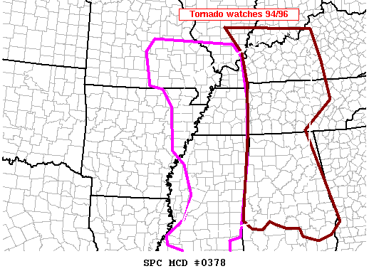
MESOSCALE DISCUSSION 0378
NWS STORM PREDICTION CENTER NORMAN OK
0201 PM CDT SAT APR 24 2010

AREAS AFFECTED...LWR OH/TN VLYS...MID-SOUTH

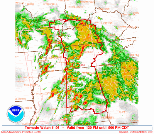
CONCERNING...TORNADO WATCH 94...96...

VALID 241901Z - 242030Z

THE SEVERE WEATHER THREAT FOR TORNADO WATCH 94...96...CONTINUES.

HIGHEST RISK FOR STRONG TORNADOES WILL EXIST FROM NRN MS/AL NWD
THROUGH WRN/MIDDLE TN...WRN/CNTRL KY AND EXTREME SRN IL/IND THROUGH
LATE AFTN. HERE...STRONGEST JUXTAPOSITION OF LOW-LEVEL SHEAR AND
LARGE SCALE ASCENT WILL BE MAXIMIZED.

LATEST MESOANALYSIS PLACES STRONGEST PRESSURE FALLS OVER WRN KY AT
18Z AND ISALLOBARIC RESPONSE IS RESULTING IN 0-1KM SRH IN EXCESS OF
500 M2/S2 FROM THE LWR OH VLY SWD INTO TN VLY. SFC DEW POINTS HAVE
RISEN WELL INTO THE 60S AS FAR N AS SRN IL AND SWRN IND AND THE 70S
TO ALONG THE TN/MS BORDER...RESULTING IN SUFFICIENT CAPE TO SUPPORT
STORMS. 18Z JACKSON SOUNDING SUGGESTED INCREASED CAPPING INVERSION
AROUND H7 MAY BE INHIBITING SUSTAINED DEEP MOIST CONVECTION SOUTH OF
THE LATITUDE OF JACKSON MS ACROSS LA/SRN MS.

MEANWHILE...FARTHER TO THE S AND E ACROSS CNTRL/SRN AL...CONVECTION
HAS BEEN BACKBUILDING ALONG SW EDGE OF MORNING STORMS. LOW-LEVEL
THETA-E AXIS HAS BEEN TRYING TO BUILD NEWD EARLY THIS AFTN AND MAY
EVENTUALLY WORK TOWARD THE GA/AL BORDER AREA BY 22Z OR SO.
INCREASING WAA AND LARGE SCALE ASCENT WILL LIKELY RESULT IN AN
INCREASE IN SVR STORMS THROUGH THE AFTN. FAVORABLE SHEAR PROFILES
AND IMPROVING THERMODYNAMICS WILL PROBABLY RESULT IN AN INCREASE IN
TORNADO RISKS...PARTICULARLY IN THE ZONE ACROSS THE SRN HALF OF
TORNADO WATCH 96.

..RACY.. 04/24/2010


ATTN...WFO...MRX...LMK...OHX...BMX...HUN...MOB...PAH...MEG...
JAN...
0 likes   

User avatar
Dave
Retired Staff
Retired Staff
Posts: 13442
Age: 74
Joined: Tue Aug 01, 2006 3:57 pm
Location: Milan Indiana
Contact:

#413 Postby Dave » Sat Apr 24, 2010 2:07 pm

Western TN & Ky getting active also.
0 likes   

User avatar
btangy
Professional-Met
Professional-Met
Posts: 758
Joined: Fri Sep 19, 2003 11:06 pm
Location: Boulder, CO
Contact:

#414 Postby btangy » Sat Apr 24, 2010 2:12 pm

Starkville looks like they may have been blasted with the rear flank downdraft given that radial velocities were in excess of hurricane force, but any tornado is passing just a hair to the N and W of the city. I think there would have also been visual confirmation of a large tornado if one existed (no wording of 'large and violent tornado' from the NWS in their warnings), but the radar signature is beginning to look better on radar and West Point, MS (pop: 11,292) needs to watch out as they look like they are in the cross hairs next.

Image
0 likes   

CrazyC83
Professional-Met
Professional-Met
Posts: 34001
Joined: Tue Mar 07, 2006 11:57 pm
Location: Deep South, for the first time!

#415 Postby CrazyC83 » Sat Apr 24, 2010 2:16 pm

Haven't heard of any fatalities though, yet...
0 likes   

User avatar
srainhoutx
S2K Supporter
S2K Supporter
Posts: 6919
Age: 67
Joined: Sun Jan 14, 2007 11:34 am
Location: Haywood County, NC
Contact:

Re: Severe Weather Threat. April 21st-25th, 2010 High Risk!

#416 Postby srainhoutx » Sat Apr 24, 2010 2:18 pm

Columbus AFB looks to be in line for the Yazoo City tornado shortly.
0 likes   
Carla/Alicia/Jerry(In The Eye)/Michelle/Charley/Ivan/Dennis/Katrina/Rita/Wilma/Ike/Harvey

Member: National Weather Association
Wx Infinity Forums
http://wxinfinity.com/index.php

Facebook.com/WeatherInfinity
Twitter @WeatherInfinity

User avatar
Dave
Retired Staff
Retired Staff
Posts: 13442
Age: 74
Joined: Tue Aug 01, 2006 3:57 pm
Location: Milan Indiana
Contact:

#417 Postby Dave » Sat Apr 24, 2010 2:21 pm

Image
0 likes   

User avatar
Bunkertor
Category 5
Category 5
Posts: 3397
Joined: Tue May 09, 2006 3:48 pm

Re: Severe Weather Threat. April 21st-25th, 2010 High Risk!

#418 Postby Bunkertor » Sat Apr 24, 2010 2:21 pm

srainhoutx wrote:Columbus AFB looks to be in line for the Yazoo City tornado shortly.

Stormchaser Michael Brewer might intercept it

Edit: Might be a different one. TVS near Starksville - east of West Point
0 likes   

User avatar
srainhoutx
S2K Supporter
S2K Supporter
Posts: 6919
Age: 67
Joined: Sun Jan 14, 2007 11:34 am
Location: Haywood County, NC
Contact:

Re: Severe Weather Threat. April 21st-25th, 2010 High Risk!

#419 Postby srainhoutx » Sat Apr 24, 2010 2:30 pm

PRELIMINARY LOCAL STORM REPORT
NATIONAL WEATHER SERVICE JACKSON MS
227 PM CDT SAT APR 24 2010

..TIME... ...EVENT... ...CITY LOCATION... ...LAT.LON...
..DATE... ....MAG.... ..COUNTY LOCATION..ST.. ...SOURCE....
..REMARKS..

0206 PM TORNADO 5 N STARKVILLE 33.53N 88.82W
04/24/2010 OKTIBBEHA MS EMERGENCY MNGR

TRAILER HOME OVERTURNED...POWERLINES DOWN...TREES DOWN
ACROSS HWY 389 AND HWY 50
0 likes   
Carla/Alicia/Jerry(In The Eye)/Michelle/Charley/Ivan/Dennis/Katrina/Rita/Wilma/Ike/Harvey

Member: National Weather Association
Wx Infinity Forums
http://wxinfinity.com/index.php

Facebook.com/WeatherInfinity
Twitter @WeatherInfinity

User avatar
btangy
Professional-Met
Professional-Met
Posts: 758
Joined: Fri Sep 19, 2003 11:06 pm
Location: Boulder, CO
Contact:

#420 Postby btangy » Sat Apr 24, 2010 2:32 pm

Still quite an inversion right below 700 mb at Jackson. Any activity will have to break through this inversion with the best chance of seeing something bust through it in locations where it's clearing ahead of the cold front. It's a narrow window, but could still be looking at more tornadic storms later this afternoon and high risk remains.

Image
Last edited by btangy on Sat Apr 24, 2010 2:44 pm, edited 2 times in total.
0 likes   


Return to “USA & Caribbean Weather”

Who is online

Users browsing this forum: TexasF6 and 33 guests