Severe Weather Threat. April 21st-25th, 2010 High Risk!

U.S. & Caribbean Weather Discussions and Severe Weather Events

Moderator: S2k Moderators

Forum rules

The posts in this forum are NOT official forecast and should not be used as such. They are just the opinion of the poster and may or may not be backed by sound meteorological data. They are NOT endorsed by any professional institution or STORM2K.

Help Support Storm2K
Message
Author
User avatar
srainhoutx
S2K Supporter
S2K Supporter
Posts: 6919
Age: 67
Joined: Sun Jan 14, 2007 11:34 am
Location: Haywood County, NC
Contact:

Re: Severe Weather Threat. April 21st-25th, 2010 High Risk!

#481 Postby srainhoutx » Mon Apr 26, 2010 8:15 am

April 23-24, 2010 Severe Weather Outbreak

Preliminary Storm Survey Information from Tallulah Louisiana to Durant Mississippi as of 4/25/2010.

NWS survey teams surveyed the path of the storm from its start from west of Tallulah, Louisiana to as far as Durant, Mississippi. Tornado damage much of it strong was found along the entire path...at least in those areas accessible by road.

Summary of Survey Information:

Path length: 97 miles...this path will increase as more damage will be surveyed east of the 4/25 survey. Maximum Width: 1.75 miles Rating: EF-4 with maximum winds of 170 mph. Casualties: 10 total fatalities with dozens of injuries.

A number of areas of EF-3 damage with estimated winds of 150 to 165 mph were found along the path. Two areas of EF-4 damage with maximum winds of 170 mph were found...one in Yazoo City...and the other in Holmes county.

Preliminary Storm Survey Information in Choctaw County

NWS survey teams surveyed the path of the storm in Choctaw county. This damage has been determined to be at least a high end EF-3. Whether or not this is part of the same continuous tornado path all the way back to its start in northeast Louisiana has yet to be determined.

NWS survey teams will be in Holmes...Attala...and Choctaw counties again on Monday to try to determine this and will be attempting to obtain aerial data to help confirm a continuous path.

It must be stressed that all of this information is preliminary and subject to later adjustment. A tornado of this strength and magnitude requires a tremendous amount of damage surveys and data analysis. The NWS will continue to provide updates as additional information is obtained and is planning a full media briefing later this week to provide a full analysis of the storm and the damage surveys results.

The NWS would like to thank all of our partners in law enforcement and emergency management for their invaluable assistance in performing our damage surveys.

As storm survey findings become available, that information will be posted to this space over the next several days.

Preliminary Storm Survey Information for Smith County

Preliminary information from surveys of the track of the tornado that moved over Smith county. The beginning of the tornado track started from 9 miles southwest of Raleigh at 840 am. It was rated as an EF-1. The path length was 10 miles with a maximum width of 50 yards. No fatalities or injuries were reported. A number of small trees were snapped, large limbs down and 2 large hardwood trees were uprooted.

Preliminary Storm Survey Information for Jasper and Lauderdale Counties

Preliminary information from surveys of the track of the tornado that moved over Jasper and Lauderdale counties. The beginning of the tornado track started from 2 miles northeast of Montrose at 915 am. It was rated as an EF-2. The path length was 28 miles with a maximum width of 0.6 of a mile. No fatalities or injuries were reported. Major structural damage to a church with roof damage. Shingles and siding were blown off of a house and an outbuilding was destroyed along with damage to a grain silo. Numerous large and very large softwood and hardwood trees were snapped and uprooted.

Preliminary Storm Survey Information for Lauderdale and Kemper Counties

Preliminary information from surveys of the track of the tornado that moved over Lauderdale and Kemper counties. The beginning of the tornado track started from 2 miles southwest of Prismatic of Montrose at 730 pm. It was rated as an EF-1. The path length was 3.6 miles with a maximum width of 100 yards. No fatalities or injuries were reported. Four barns were destroyed or damaged, a portion of metal building roof was torn off, and one shed was destroyed. Numerous medium and large trees were snapped along the path.

Event Summary

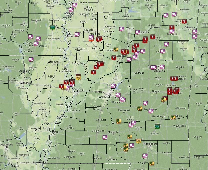
A potent storm system brought an extended period of severe weather to the Arklamiss region beginning in the afternoon hours of Friday, April 23rd and lasting through the late evening hours of Saturday, April 24th. Scattered severe thunderstorms developed and moved across northeastern Louisiana and parts of Mississippi during the afternoon and evening hours. Several reports of large hail were received from across the area, including golf ball size hail in Sunflower County. In addition, some wind damage was reported over southern portions of Leflore County in association with a possible tornado.

Though the storms on Friday did not cause widespread damage, a much more dangerous situation unfolded across the region on Saturday. Initially, two separate clusters of strong to severe thunderstorms affected the area during the morning hours. One moved across southeastern Arkansas and northwestern Mississippi, dropping hail up to golf ball size. Another moved across south central and southeastern Mississippi, producing large hail and some wind damage. One of the storms over southern Mississippi produced a possible tornado as it moved from southern Simpson County across Smith County, northern Jasper County, and into the Meridian area in Lauderdale County. The same storm produced golf ball size hail across Smith County.

However, the most destructive storm of the day developed over northern Louisiana during the mid to late morning hours. The first report of damage was received shortly after 11am near the city of Tallulah. From that point, things only got worse as the supercell tracked from west to east across the entire state of Mississippi. Along the way, it produced significant damage in several locations including the Eagle Lake area of Warren County, Valley Park in Issaquena County, Satartia and Yazoo City in Yazoo County, Ebenezer and Durant in Holmes County, north of Kosciusko near Hesterville in Attala County, French Camp and Chester in Choctaw County, north of Starkville in Oktibbeha County, and east of West Point in Clay County. Multiple fatalities and injuries were reported in association with the storm, and several structures were damaged or destroyed.

Later in the evening hours, additional storms lingered over portions of east central Mississippi. Large hail was reported with some of these storms, including hail to the size of tennis balls in southern Lowndes County. One storm northwest of Meridian produced an apparent tornado along the Lauderdale-Kemper County line. Several trees were downed and some minor structural damage was reported in the area.

Storm Reports

Below is a map of severe weather reports (including hail, damaging winds, tornadoes, and flash flooding) received by the National Weather Service in Jackson from this event.


http://www.srh.noaa.gov/jan/?n=2010_04_24_tor_overview

Image
0 likes   
Carla/Alicia/Jerry(In The Eye)/Michelle/Charley/Ivan/Dennis/Katrina/Rita/Wilma/Ike/Harvey

Member: National Weather Association
Wx Infinity Forums
http://wxinfinity.com/index.php

Facebook.com/WeatherInfinity
Twitter @WeatherInfinity

JonathanBelles
Professional-Met
Professional-Met
Posts: 11430
Age: 34
Joined: Sat Dec 24, 2005 9:00 pm
Location: School: Florida State University (Tallahassee, FL) Home: St. Petersburg, Florida
Contact:

#482 Postby JonathanBelles » Mon Apr 26, 2010 9:54 am

Can somebody put together a map of all the tornado watches over the last week, and the severe T-Storm watches too. They had to have covered 2/3rds of the country!!
0 likes   

CrazyC83
Professional-Met
Professional-Met
Posts: 34001
Joined: Tue Mar 07, 2006 11:57 pm
Location: Deep South, for the first time!

Re:

#483 Postby CrazyC83 » Mon Apr 26, 2010 10:00 am

fact789 wrote:Can somebody put together a map of all the tornado watches over the last week, and the severe T-Storm watches too. They had to have covered 2/3rds of the country!!


There were a total of 36 watches issued since Wednesday.
0 likes   

User avatar
Dave
Retired Staff
Retired Staff
Posts: 13442
Age: 74
Joined: Tue Aug 01, 2006 3:57 pm
Location: Milan Indiana
Contact:

#484 Postby Dave » Mon Apr 26, 2010 12:08 pm

PUBLIC INFORMATION STATEMENT
NATIONAL WEATHER SERVICE LOUISVILLE KY
458 PM EDT SUN APR 25 2010 /358 PM CDT SUN APR 25 2010/

...NATIONAL WEATHER SERVICE CONFIRMS EF-1 TORNADO TOUCHED DOWN IN
NORTHWEST EDMONSON COUNTY...

A STORM DAMAGE SURVEY TEAM CONSISTING OF NWS EMPLOYEES AND EDMONSON
COUNTY EMERGENCY MANAGEMENT CONCLUDED THAT AN EF-1 TORNADO WITH WIND
SPEEDS OF 100 MILES PER HOUR TOUCHED DOWN IN NORTHWEST EDMONSON
COUNTY AT 540 PM CDT SATURDAY APRIL 24 2010. THE TORNADO WAS ON THE
GROUND FOR 2 MINUTES. THE 50 YARD WIDE DAMAGE PATH STARTED NEAR
SUNFISH AND TRAVELED EAST SOUTHEAST FOR 1.1 MILES. ALONG THE PATH...
A WELL BUILT HOME SUFFERED SIGNIFICANT DAMAGE ALONG WITH A SHED THAT
WAS DESTROYED. ALSO...SEVERAL OUTBUILDINGS WERE DAMAGED AND NUMEROUS
HARDWOOD AND SOFTWOOD TREES WERE EITHER UPROOTED OR SNAPPED. TO THE
SOUTH OF THE TORNADO DAMAGE PATH...AN AREA OF STRAIGHT LINE WIND
DAMAGE OCCURRED.

BEGIN TIME: SATURDAY APRIL 24 2010 - 540 PM CDT
END TIME: SATURDAY APRIL 24 2010 - 542 PM CDT
LOCATION BEGIN: JUST EAST OF SUNFISH IN NORTHWEST EDMONSON COUNTY.
LOCATION END: 1.1 MILES EAST SOUTHEAST OF SUNFISH.
EF-SCALE RATING: EF-1
ESTIMATED WIND SPEEDS: 100 MPH
PATH LENGTH 1.1 MILES
PATH WIDTH: 50 YARDS
INJURIES: NONE
FATALITIES: NONE

Map & Damage pictures here...

http://www.crh.noaa.gov/news/display_cm ... 5&source=0
0 likes   

User avatar
Dave
Retired Staff
Retired Staff
Posts: 13442
Age: 74
Joined: Tue Aug 01, 2006 3:57 pm
Location: Milan Indiana
Contact:

#485 Postby Dave » Mon Apr 26, 2010 12:12 pm

Storm Survey Complete for Christian/Todd KY
PUBLIC INFORMATION STATEMENTNATIONAL WEATHER SERVICE PADUCAH KY846 PM CDT SUN APR 25 2010...

DAMAGE SURVEY RESULTS FOR EXTREME SOUTHEAST CHRISTIAN ANDSOUTHWEST TODD COUNTIES...THE FOLLOWING IS THE PRELIMINARY DAMAGE ASSESSMENT FOR APRIL 24 EVENT # 1 FOR CHRISTIAN AND TODD COUNTIES. IN ADDITION,INITIAL/INCOMPLETE SURVEYING WAS CONDUCTED INTO FAR NORTHERNMONTGOMERY COUNTY IN TENNESSEE.* EVENT DATE - SATURDAY APRIL 24 2010* EVENT TIME - 4:43 PM CDT UNTIL 4:55 PM* EVENT TYPE - MICROBURST* EVENT LOCATION - FROM 2 MILES SOUTHEAST OF OAK GROVE, KY (ALONG/SOUTH OF THE KY-TN STATE LINE) TO 3 1/2 MILES SOUTHEAST OF TRENTON, KY* PEAK WIND - 90 MPH* AVERAGE PATH WIDTH - 1.5 MILES* MAXIMUM PATH WIDTH - APPROXIMATELY 2 MILES* PATH LENGTH - 7+ MILES (FOR KENTUCKY PORTION, THE TENNESSEE PORTION MAY BE FURTHER SURVEYED MONDAY)* INJURIES - NONE* FATALITIES - NONE* DISCUSSION/DAMAGE - THE MICROBURST (DOWNBURST LESS THAN 2.5 MILES WIDE) DAMAGE IN KENTUCKY EXTENDED FROM ALONG THE KENTUCKY- TENNESSEE BORDER SOUTHEAST OF OAK GROVE, KY FOR APPROXIMATELY 7 MILES TO THE NORTHEAST TO U.S. HWY 41...ABOUT 3.5 MILES SOUTHEAST OF TRENTON, KY. DAMAGE WAS OBSERVED AT LEAST 1 MILE SOUTH OF THE KY-TN BORDER INTO NORTHERN MONTGOMERY COUNTY TN. MANY DOZENS OF TREES WERE UPROOTED OR BROKEN. ONE BARN WAS LEVELED, WITH SEVERAL OTHER BARNS RECEIVING MODERATE TO MAJOR DAMAGE. A FEW HOMES SUFFERED MAINLY MINOR DAMAGE (PORCH DAMAGE, PARTIAL LOSS OF SHINGLES, ETC.). DAMAGE WAS OBSERVED ALONG OR NEAR BARKERS MILL RD (HWY 1881), TRENTON RD (HWY 104), HAMMACKSVILLE RD, CHESTER STALL RD, AND U.S. HWY 41.
=================
EVENT #2

THE FOLLOWING IS THE PRELIMINARY DAMAGE ASSESSMENT FOR APRIL 24EVENT # 2 FOR CHRISTIAN AND TODD COUNTIES.* EVENT DATE - SATURDAY APRIL 24 2010* EVENT TIME - 4:23 PM CDT UNTIL 4:27 PM* EVENT TYPE - EF0 TORNADO* EVENT LOCATION - 2 MILES SOUTHEAST OF PEMBROKE, KY TO PEMBROKE, KY* PEAK WIND - 75 MPH* AVERAGE PATH WIDTH - 40 YARDS* PATH LENGTH - 2 MILES* INJURIES - NONE* FATALITIES - NONE* DISCUSSION/DAMAGE - SEVERAL TREES OR TREE LIMBS WERE BLOWN DOWN ALONG WITH MINOR DAMAGE TO A HOME (GUTTERS). THE TORNADO TRACK WAS MOSTLY ACROSS FIELDS. THE TORNADO WAS PHOTOGRAPHED NEAR THE INITIAL TOUCHDOWN ABOUT 2 MILES SOUTHWEST OF PEMBROKE, AND WAS ALSO OBSERVED ON THE GROUND LESS THAN 1 MILE FROM PEMBROKE.* SURVEYOR/S....SHANKLIN/ POWELL

http://www.crh.noaa.gov/news/display_cm ... 4&source=0
0 likes   

User avatar
Dave
Retired Staff
Retired Staff
Posts: 13442
Age: 74
Joined: Tue Aug 01, 2006 3:57 pm
Location: Milan Indiana
Contact:

#486 Postby Dave » Mon Apr 26, 2010 12:14 pm

NWS ST LOUIS MO

Preliminary storm damage survey in Des Peres - April 24th
The National Weather Service office in St. Louis conducted a survey of the storm damage that occurred near Des Peres on Saturday, April 24th 2010. An EF0 tornado with maximum winds of 70-80 mph first touched down about 0.3 miles north of Dougherty Ferry Rd near Lynkirk Rd. and moved northwestward through part of a subdivision. The tornado caused widespread tree damage and minor roof damage across the subdivision. The tornado lifted briefly, then touched down again near the intersection of Ballas Rd. and Kirk Place Drive, causing significant tree damage before it lifted and dissipated east of a shopping mall. The path was approximately 0.6 miles long with a maximum width of approximately 300 yards in part of the subdivision and an average width of less than 200 yards elsewhere. The map below shows tree and roof damage (yellow pushpins), tornado track (red line), and the location of two observers who witnessed the tornado (blue squares).


http://www.crh.noaa.gov/news/display_cm ... 1&source=0
0 likes   

User avatar
Dave
Retired Staff
Retired Staff
Posts: 13442
Age: 74
Joined: Tue Aug 01, 2006 3:57 pm
Location: Milan Indiana
Contact:

#487 Postby Dave » Mon Apr 26, 2010 12:16 pm

EF-1 Tornado Confirmed in Perry and Humphreys Counties
PUBLIC INFORMATION STATEMENTNATIONAL WEATHER SERVICE NASHVILLE TN350 PM CDT SUN APR 25 2010...

NWS CONFIRMS EF-1 TORNADO IN PERRY AND HUMPHREYS COUNTIESFROM SATURDAY...A NATIONAL WEATHER SERVICE SURVEY TEAM CONDUCTED A DAMAGE SURVEYIN PERRY AND HUMPHREYS COUNTIES.A TORNADO WITH MAX WINDS OF 100 MPH ENTERED PERRY COUNTY NEAR SIMMSROAD ALONG THE EASTERN SIDE OF THE TENNESSEE RIVER. DAMAGECONTINUED NORTHEASTWARD...FOR A LENGTH OF 13.8 MILES AND A MAXIMUMWIDTH OF 300 YARDS. HUNDREDS OF SOFT AND HARD WOOD TREES WERESNAPPED OR UPROOTED. THERE WAS SOME ROOF DAMAGE NOTED.$$SUMMARY...CAUSE OF DAMAGE...TORNADOWIND SPEED ESTIMATE...100 MPHEF SCALE...EF-1DAMAGE PATH LENGTH...13.8 MILESDAMAGE WIDTH...300 YARDSSTART POINT...35.789 -87.973END POINT...35.882 -87.754THOMAS JOHNSTONEMICHAEL E. DAVISNATIONAL WEATHER SERVICE NASHVILLE.

http://www.srh.noaa.gov/news/display_cm ... 4&source=0

==========================

EF-0 Tornado Confirmed in Macon County
PUBLIC INFORMATION STATEMENTNATIONAL WEATHER SERVICE NASHVILLE TN644 PM CDT SUN APR 25 2010...PUBLIC INFORMATION STATEMENT......

NWS CONFIRMS EF-0 TORNADO IN MACON COUNTY FROM SATURDAY...A NATIONAL WEATHER SERVICE CONDUCTED A DAMAGE SURVEY IN MACONCOUNTY.A TORNADO WITH MAX WINDS OF 85 MPH TOUCHED DOWN AT THE INTERSECTIONOF STATE HIGHWAY 52 AND ROCKY MOUND ROAD. DAMAGED CONTINUED TO THENORTH NORTHEAST FOR AN APPROXIMATELY LENGTH OF 1.5 MILES AND AMAXIMUM WIDTH OF 50 YARDS. MULTIPLE SHALLOW ROOTED TREES WERE UPROOTEDWITH ONE SMALL BARN DESTROYED.$$SUMMARY...CAUSE OF DAMAGE...TORNADOWIND SPEED ESTIMATE...85 MPHEF SCALE...EF-0DAMAGE PATH LENGTH...1.5 MILESDAMAGE WIDTH...50 YARDSSTART POINT...36.534 -86.190END POINT...36.554 -86.179MICHAEL E. DAVISNATIONAL WEATHER SERVICE NASHVILLE.

http://www.srh.noaa.gov/news/display_cm ... 1&source=0
0 likes   

User avatar
Dave
Retired Staff
Retired Staff
Posts: 13442
Age: 74
Joined: Tue Aug 01, 2006 3:57 pm
Location: Milan Indiana
Contact:

#488 Postby Dave » Mon Apr 26, 2010 12:17 pm

Microburst Confirmed in Montgomery County
PUBLIC INFORMATION STATEMENTNATIONAL WEATHER SERVICE PADUCAH KY846 PM CDT SUN APR 25 2010...

DAMAGE SURVEY RESULTS FOR EXTREME SOUTHEAST CHRISTIAN ANDSOUTHWEST TODD COUNTIES...THE FOLLOWING IS THE PRELIMINARY DAMAGE ASSESSMENT FOR APRIL 24EVENT # 1 FOR CHRISTIAN AND TODD COUNTIES. IN ADDITION,INITIAL/INCOMPLETE SURVEYING WAS CONDUCTED INTO FAR NORTHERNMONTGOMERY COUNTY IN TENNESSEE.* EVENT DATE - SATURDAY APRIL 24 2010* EVENT TIME - 4:43 PM CDT UNTIL 4:55 PM* EVENT TYPE - MICROBURST* EVENT LOCATION - FROM 2 MILES SOUTHEAST OF OAK GROVE, KY (ALONG/SOUTH OF THE KY-TN STATE LINE) TO 3 1/2 MILES SOUTHEAST OF TRENTON, KY* PEAK WIND - 90 MPH* AVERAGE PATH WIDTH - 1.5 MILES* MAXIMUM PATH WIDTH - APPROXIMATELY 2 MILES* PATH LENGTH - 7+ MILES (FOR KENTUCKY PORTION, THE TENNESSEE PORTION MAY BE FURTHER SURVEYED MONDAY)* INJURIES - NONE* FATALITIES - NONE* DISCUSSION/DAMAGE - THE MICROBURST (DOWNBURST LESS THAN 2.5 MILES WIDE) DAMAGE IN KENTUCKY EXTENDED FROM ALONG THE KENTUCKY- TENNESSEE BORDER SOUTHEAST OF OAK GROVE, KY FOR APPROXIMATELY 7 MILES TO THE NORTHEAST TO U.S. HWY 41...ABOUT 3.5 MILES SOUTHEAST OF TRENTON, KY. DAMAGE WAS OBSERVED AT LEAST 1 MILE SOUTH OF THE KY-TN BORDER INTO NORTHERN MONTGOMERY COUNTY TN. MANY DOZENS OF TREES WERE UPROOTED OR BROKEN. ONE BARN WAS LEVELED, WITH SEVERAL OTHER BARNS RECEIVING MODERATE TO MAJOR DAMAGE. A FEW HOMES SUFFERED MAINLY MINOR DAMAGE (PORCH DAMAGE, PARTIAL LOSS OF SHINGLES, ETC.). DAMAGE WAS OBSERVED ALONG OR NEAR BARKERS MILL RD (HWY 1881), TRENTON RD (HWY 104), HAMMACKSVILLE RD, CHESTER STALL RD, AND U.S. HWY 41.THE FOLLOWING IS THE PRELIMINARY DAMAGE ASSESSMENT FOR APRIL 24EVENT # 2 FOR CHRISTIAN AND TODD COUNTIES.* EVENT DATE - SATURDAY APRIL 24 2010* EVENT TIME - 4:23 PM CDT UNTIL 4:27 PM* EVENT TYPE - EF0 TORNADO* EVENT LOCATION - 2 MILES SOUTHEAST OF PEMBROKE, KY TO PEMBROKE, KY* PEAK WIND - 75 MPH* AVERAGE PATH WIDTH - 40 YARDS* PATH LENGTH - 2 MILES* INJURIES - NONE* FATALITIES - NONE* DISCUSSION/DAMAGE - SEVERAL TREES OR TREE LIMBS WERE BLOWN DOWN ALONG WITH MINOR DAMAGE TO A HOME (GUTTERS). THE TORNADO TRACK WAS MOSTLY ACROSS FIELDS. THE TORNADO WAS PHOTOGRAPHED NEAR THE INITIAL TOUCHDOWN ABOUT 2 MILES SOUTHWEST OF PEMBROKE, AND WAS ALSO OBSERVED ON THE GROUND LESS THAN 1 MILE FROM PEMBROKE.* SURVEYOR/S....SHANKLIN/ POWELL$$

http://www.srh.noaa.gov/news/display_cm ... 7&source=0
0 likes   

User avatar
LSU2001
S2K Supporter
S2K Supporter
Posts: 1711
Age: 57
Joined: Sat Sep 11, 2004 11:01 pm
Location: Cut Off, Louisiana

#489 Postby LSU2001 » Mon Apr 26, 2010 12:28 pm

This pic was posted on another board said to be the yazoo city tornado. However, the pic looks familiar. I was also under the impression that the storm was rain wrapped and very difficult to see. Can anyone verify if this is an actual pic of the storm>
Thanks,
Tim

http://images.yuku.com/image/x-png/9653 ... b39ee7.png

nevermind guys, found it myself. the above image is not the yazoo tornado it is a kansas tornado from 2009 according to this link

http://mapofkansas.wordpress.com/2009/0 ... t-tornado/
0 likes   
Personal Forecast Disclaimer:
The posts in this forum are NOT official forecast and should not be used as such. They are NOT endorsed by any professional institution or storm2k.org. For official information, please refer to the NHC and NWS products.

User avatar
vbhoutex
Storm2k Executive
Storm2k Executive
Posts: 29096
Age: 73
Joined: Wed Oct 09, 2002 11:31 pm
Location: Cypress, TX
Contact:

Re: Severe Weather Threat. April 21st-25th, 2010 High Risk!

#490 Postby vbhoutex » Mon Apr 26, 2010 2:50 pm

That is photoshopped and had been around since at least 2005 when people were posting that it was Hurricane Katrina making landfall. It isn't even a tornado.
0 likes   
Skywarn, C.E.R.T.
Please click below to donate to STORM2K to help with the expenses of keeping the site going:
Image

CajunMama
Retired Staff
Retired Staff
Posts: 10791
Joined: Thu Feb 06, 2003 9:57 pm
Location: 30.22N, 92.05W Lafayette, LA

Re: Severe Weather Threat. April 21st-25th, 2010 High Risk!

#491 Postby CajunMama » Mon Apr 26, 2010 2:53 pm

2 storm chasers were on the cbs early show. Take a look at their video and interview about the yazoo city tornado.
Chasers Catch Twister On Tape

Thanks to ChaserTV on fb for the link.
0 likes   

User avatar
LSU2001
S2K Supporter
S2K Supporter
Posts: 1711
Age: 57
Joined: Sat Sep 11, 2004 11:01 pm
Location: Cut Off, Louisiana

Re: Severe Weather Threat. April 21st-25th, 2010 High Risk!

#492 Postby LSU2001 » Mon Apr 26, 2010 6:34 pm

Thanks a bunch Vbhoutex, i thought it looked fishy.
oh yeah,
hey mama
TIm
0 likes   
Personal Forecast Disclaimer:
The posts in this forum are NOT official forecast and should not be used as such. They are NOT endorsed by any professional institution or storm2k.org. For official information, please refer to the NHC and NWS products.

User avatar
srainhoutx
S2K Supporter
S2K Supporter
Posts: 6919
Age: 67
Joined: Sun Jan 14, 2007 11:34 am
Location: Haywood County, NC
Contact:

Re: Severe Weather Threat. April 21st-25th, 2010 High Risk!

#493 Postby srainhoutx » Mon Apr 26, 2010 6:37 pm

Appears the Yazoo City Tornado was an EF-4 as well as a long tracker...

PUBLIC INFORMATION STATEMENT
NATIONAL WEATHER SERVICE JACKSON MS
620 PM CDT MON APR 26 2010

...UPDATED INFORMATION ON LONG TRACK TORNADO PATH...

NWS STORM SURVEY TEAMS FROM JACKSON AND MEMPHIS HAVE NOW
COMPLETED PRELIMINARY GROUND SURVEYS ALONG THE ENTIRE PATH
OF THE PRIMARY SUPERCELL THUNDERSTORM THAT TRACKED FROM
WEST OF TALLULAH, LOUISIANA...TO YAZOO CITY...TO NORTHEAST
OF WEST POINT...ON SATURDAY APRIL 26.

THE PRELMINARY CONCLUSION BASED ON THE GROUND SURVEYS IS
THAT A SINGLE...CONTINUOUS PATH OF TORNADIC DAMAGE WAS
PRODUCED FROM WEST OF TALLULAH TO THE EXTREME WESTERN PART
OF OKTIBBEHA COUNTY IN NORTHEAST MISSISSIPPI. THE TORNADO
APPEARED TO DISSIPATE AT THIS POINT...BUT THE STORM PRODUCED
TWO ADDITIONAL TORNADOES IN THE NWS JACKSON SERVICE AREA...
AN EF-1 IN NORTHERN OKTIBBEHA COUNTY...AND AN EF-2 IN
NORTHEAST CLAY COUNTY. INFORMATION REGARDING THESE TORNADOES
HAS BEEN PROVIDED IN EARLIER STATEMENTS.

THE MAIN LONG TRACK TORNADO WAS STRONG ALMOST FROM ITS INITIAL
STAGE OF DEVELOPMENT IN NORTHEAST LOUISIANA. EF-2 AND
EF-3 DAMAGE WAS COMMON ALL ALONG THE TORNADO`S PATH INTO
CENTRAL MISSISSIPPI...WITH TWO AREAS OF EF-4 DAMAGE IN YAZOO
AND HOLMES COUNTIES. AFTER CROSSING INTERSTATE 55...THE TORNADO
WEAKENED...WITH EF-1 AND OCCASIONAL EF-2 DAMAGE BEING COMMON
AS THE TORNADO MOVED ACROSS ATTALA COUNTY. THE TORNADO REINTENSIFIED
AS IT MOVED INTO CHOCTAW COUNTY...WITH AT LEAST HIGH END EF-3 DAMAGE
OCCURRING NORTHWEST OF THE WEIR COMMUNITY. THE TORNADO REMAINED
STRONG BEFORE RAPIDLY WEAKENING AND THEN DISSIPATING JUST AFTER
MOVING INTO OKTIBBEHA COUNTY.

HERE IS A PRELIMINARY SUMMARY OF THIS TORNADO:

BEGINNING POINT: 5 MILES W OF TALLULAH, LA 32.408N, 91.283W
AT 11:06 AM
ENDING POINT: 5.5 MILES N OF STURGIS, MS 33.430N, 89.054W
AT 1:52 PM
PATH LENGTH: 149 MILES
MAXIMUM WIDTH: 1.75 MILES
RATING: EF-4, WITH MAXIMUM WINDS OF 170 MPH
CASUALTIES: 10 TOTAL FATALITIES WITH DOZENS OF INJURIES

IT MUST BE STRESSED THAT ALL OF THIS INFORMATION IS PRELIMINARY
AND SUBJECT TO LATER ADJUSTMENT. A TORNADO OF THIS STRENGTH AND
MAGNITUDE REQUIRES A TREMENDOUS AMOUNT OF DAMAGE SURVEYS AND DATA
ANALYSIS. AN ANALYSIS OF AERIAL SURVEY INFORMATION COULD STILL
RESULT IN THE TORNADO BEING BROKEN UP INTO MORE THAN ONE PATH.

THE NWS WILL CONTINUE TO PROVIDE UPDATES AS ADDITIONAL
INFORMATION IS OBTAINED...AND IS PLANNING TO HOLD A MEDIA BRIEFING
LATER THIS WEEK TO PROVIDE A FULL ANALYSIS OF THE STORM AND THE
DAMAGE SURVEY RESULTS. ALSO...A WEBPAGE CONCERNING THIS WEATHER
EVENT...INCLUDING DAMAGE PICTURES AND MAPS...WILL BE UPDATED AT
http://WWW.SRH.NOAA.GOV/JAN.

THE NWS WOULD LIKE TO THANK ALL OF OUR PARTNERS IN LAW ENFORCEMENT
AND EMERGENCY MANAGEMENT FOR THEIR INVALUABLE ASSISTANCE IN
PERFORMING OUR DAMAGE SURVEYS.


http://forecast.weather.gov/product.php ... suedby=JAN
0 likes   
Carla/Alicia/Jerry(In The Eye)/Michelle/Charley/Ivan/Dennis/Katrina/Rita/Wilma/Ike/Harvey

Member: National Weather Association
Wx Infinity Forums
http://wxinfinity.com/index.php

Facebook.com/WeatherInfinity
Twitter @WeatherInfinity

User avatar
vbhoutex
Storm2k Executive
Storm2k Executive
Posts: 29096
Age: 73
Joined: Wed Oct 09, 2002 11:31 pm
Location: Cypress, TX
Contact:

Re: Severe Weather Threat. April 21st-25th, 2010 High Risk!

#494 Postby vbhoutex » Mon Apr 26, 2010 6:44 pm

:uarrow: The particular cell that produced this tornado actually started in Montgomery County, Texas just North of Houston and was tracked for a length of 600 miles!! I heard that on the local news today.
0 likes   
Skywarn, C.E.R.T.
Please click below to donate to STORM2K to help with the expenses of keeping the site going:
Image

User avatar
somethingfunny
ChatStaff
ChatStaff
Posts: 3926
Age: 36
Joined: Thu May 31, 2007 10:30 pm
Location: McKinney, Texas

Re: Severe Weather Threat. April 21st-25th, 2010 High Risk!

#495 Postby somethingfunny » Tue Apr 27, 2010 4:29 pm

HOLY SMOKES, a video was taken of the tornado as it crossed Interstate 55. This could be the most incredible tornado video I have EVER seen! :eek: :eek: :eek: :eek:

[youtube]http://www.youtube.com/watch?v=Sl4dAt_o0AI[/youtube]

I don't think the video is supposed to be on Youtube as it was bootlegged from a mainstream news outlet's stream, so it might not be online for long - this is the only way to embed in our forums though.

Here's a direct link:
http://www2.nbc13.com/vtm/news/local/ar ... do/149003/
0 likes   

CrazyC83
Professional-Met
Professional-Met
Posts: 34001
Joined: Tue Mar 07, 2006 11:57 pm
Location: Deep South, for the first time!

#496 Postby CrazyC83 » Tue Apr 27, 2010 6:46 pm

One of the storms in DeKalb County, Alabama was upgraded to EF4...

000
NOUS44 KHUN 272156
PNSHUN
ALZ001>010-016-TNZ076-096-097-281400-

PUBLIC INFORMATION STATEMENT
NATIONAL WEATHER SERVICE HUNTSVILLE AL
456 PM CDT TUE APR 27 2010

...UPDATED STORM SURVEY INFORMATION ON MOUNT VERNON TORNADO IN
DEKALB COUNTY...

...TORNADO HAS BEEN UPGRADED FROM EF-3 TO EF-4 INTENSITY...

MORE DETAILED SURVEY INFORMATION OF THE TORNADO THAT IMPACTED
AREAS FROM MOUNT VERNON TO DOG TOWN IN SOUTHEAST DEKALB COUNTY HAS
BEEN COMPLETED BY NATIONAL WEATHER SERVICE AND LOCAL EMERGENCY
MANAGEMENT PERSONNEL. ADDITIONAL FINDINGS ARE AS FOLLOWS:

* EVENT TYPE: TORNADO
* EVENT DATE: 04/24/10

* ESTIMATED PEAK WIND: 170 MPH
* PRELIMINARY RATING: EF-4

* PATH LENGTH: 7.3 MILES
* MAXIMUM PATH WIDTH: 1/4 TO 1/2 MILE

* INJURIES: AT LEAST 5
* SUMMARY: AS PART OF A SEPARATE STORM...THIS TORNADO IMPACTED
AREAS FROM MOUNT VERNON TO DOG TOWN IN EXTREME SOUTHEAST DEKALB
COUNTY. THE MOST SIGNIFICANT DAMAGE OCCURRED NEAR THE
INTERSECTION OF COUNTY ROAD 80 AND 55 WHERE THE MCNUTT MEMORIAL
UNITED METHODIST CHURCH AND A TWO-STORY RESIDENCE ACROSS THE
STREET WERE BOTH DESTROYED. OAK TREES NEARBY WERE DEBARKED AS
WELL. SOME STRUCTURAL DAMAGE TO RESIDENCES ALONG COUNTY ROAD 79
OCCURRED...JUST WEST OF HIGHWAY 176. FARTHER WEST WHERE THE
TORNADO INITIALLY TOUCHED DOWN...SEVERAL SINGLE WIDE MANUFACTURED
HOMES WERE DESTROYED ALONG COUNTY ROAD 60...BETWEEN COUNTY ROAD
822 AND 892. NUMEROUS LARGE TREES WERE SNAPPED OR UPROOTED.

SEVERAL INJURIES OCCURRED WITH THIS TORNADO BUT AN EXACT NUMBER
IS UNKNOWN AT THIS TIME.

THESE FINDINGS ARE PRELIMINARY AND ARE SUBJECT TO ADJUSTMENT.
PICTURES AND SUMMARY MATERIALS WILL BE MADE AVAILABLE ON OUR WEB
PAGE AT WEATHER.GOV/HUNTSVILLE /ALL LOWER CASE/.

SURVEYED BY: NADLER/AMIN

$$
0 likes   


Return to “USA & Caribbean Weather”

Who is online

Users browsing this forum: TexasF6 and 33 guests