ENSO Updates (2007 thru 2023)
Moderator: S2k Moderators
Forum rules

The posts in this forum are NOT official forecasts and should not be used as such. They are just the opinion of the poster and may or may not be backed by sound meteorological data. They are NOT endorsed by any professional institution or STORM2K. For official information, please refer to products from the National Hurricane Center and National Weather Service.
-
brunota2003

- S2K Supporter

- Posts: 9476
- Age: 35
- Joined: Sat Jul 30, 2005 9:56 pm
- Location: Stanton, KY...formerly Havelock, NC
- Contact:


Re: Re:
cycloneye wrote:
What I have heard is that there is a lag of time for the atmospheric conditions to catch up to Neutral or La Nina. For example,ENSO is at Neutral from now,it may take a month to get conditions of Neutral.But I may be wrong on this so I better wait for one of our pro mets to tell us the real deal with this.
It varies with every set-up, but with this set-up the El Nino's effects seem to have more or less gone already, and in the Atlantic its effects haven't really been felt since early April if you look at the shear anomalies...If we were to go La Nina I'd think you'd only be looking at a 2-3 week delay before the atmosphere quickly shifts given the set-up we are in....however I'm still not convinced La Nina is going to happen, at least for the peak of the season.
0 likes
Personal Forecast Disclaimer:
The posts in this forum are NOT official forecast and should not be used as such. They are just the opinion of the poster and may or may not be backed by sound meteorological data. They are NOT endorsed by any professional institution or storm2k.org. For official information, please refer to the NHC and NWS products
The posts in this forum are NOT official forecast and should not be used as such. They are just the opinion of the poster and may or may not be backed by sound meteorological data. They are NOT endorsed by any professional institution or storm2k.org. For official information, please refer to the NHC and NWS products
Re: Re:
Looking at the numbers from recent enso neutral seasons vs. la nina seasons vs. el nino seasons, it seems the absence of el nino (and the corresponding hostile conditions for development) is a bigger determining factor than whether or not conditions are neutral or la nina when it comes to # of storms.
If you add in the possibility of warmer than normal sst in the basin and lower than normal pressure.....whether we are neutral or la nina by peak season, the potential overall favorable dynamics suggest a high # of storms developing. Where they will go is the $64,000 question!

If you add in the possibility of warmer than normal sst in the basin and lower than normal pressure.....whether we are neutral or la nina by peak season, the potential overall favorable dynamics suggest a high # of storms developing. Where they will go is the $64,000 question!
KWT wrote:cycloneye wrote:
What I have heard is that there is a lag of time for the atmospheric conditions to catch up to Neutral or La Nina. For example,ENSO is at Neutral from now,it may take a month to get conditions of Neutral.But I may be wrong on this so I better wait for one of our pro mets to tell us the real deal with this.
It varies with every set-up, but with this set-up the El Nino's effects seem to have more or less gone already, and in the Atlantic its effects haven't really been felt since early April if you look at the shear anomalies...If we were to go La Nina I'd think you'd only be looking at a 2-3 week delay before the atmosphere quickly shifts given the set-up we are in....however I'm still not convinced La Nina is going to happen, at least for the peak of the season.
0 likes
Without a doubt, in fact I'd argue it is the warm cycle that makes no difference between neutral and La Nina because the warmer waters in the warm cycle makes up the difference between neutral and any slightly more favourable conditions in La Nina.
Also in La Nina you tend to find the Atlantic will cool as well (typically I've found there is something of a mirror image in the Atlantic, esp if you get a long La Nina as we saw by 08-09 winter.) which also is quite interesting I've found.
Also in La Nina you tend to find the Atlantic will cool as well (typically I've found there is something of a mirror image in the Atlantic, esp if you get a long La Nina as we saw by 08-09 winter.) which also is quite interesting I've found.
0 likes
Personal Forecast Disclaimer:
The posts in this forum are NOT official forecast and should not be used as such. They are just the opinion of the poster and may or may not be backed by sound meteorological data. They are NOT endorsed by any professional institution or storm2k.org. For official information, please refer to the NHC and NWS products
The posts in this forum are NOT official forecast and should not be used as such. They are just the opinion of the poster and may or may not be backed by sound meteorological data. They are NOT endorsed by any professional institution or storm2k.org. For official information, please refer to the NHC and NWS products
Re:
Looking at those numbers in the chart, it is neutral seasons that have averaged the highest # of majors in a season...with no less than 3....and ranging up to 7....for those seasons. Recent la nina seasons have had between 2 and 5 majors.
When you consider the season ahead....neutral (most likely) phase, warmer than avg sst, lower than normal pressures basin wide (current forecast)....there is not alot that seems to be overwhelmingly and persistently negative to a lot of development. The key will of course be track. Lots of fishes vs. lots of landfalls will be what makes the difference.
When you consider the season ahead....neutral (most likely) phase, warmer than avg sst, lower than normal pressures basin wide (current forecast)....there is not alot that seems to be overwhelmingly and persistently negative to a lot of development. The key will of course be track. Lots of fishes vs. lots of landfalls will be what makes the difference.
KWT wrote:Without a doubt, in fact I'd argue it is the warm cycle that makes no difference between neutral and La Nina because the warmer waters in the warm cycle makes up the difference between neutral and any slightly more favourable conditions in La Nina.
Also in La Nina you tend to find the Atlantic will cool as well (typically I've found there is something of a mirror image in the Atlantic, esp if you get a long La Nina as we saw by 08-09 winter.) which also is quite interesting I've found.
Last edited by jinftl on Sun May 02, 2010 8:42 am, edited 1 time in total.
0 likes
Yeah thats true.
I think if its just a one shot La Nina (just the one year) then they tend to be fairly active but if you get a protracted La Nina the gradual effect it has on the Atlantic SST's downstream after 12-18 months starts to really reduce any real positive effect the lesser shear does have.
I think if its just a one shot La Nina (just the one year) then they tend to be fairly active but if you get a protracted La Nina the gradual effect it has on the Atlantic SST's downstream after 12-18 months starts to really reduce any real positive effect the lesser shear does have.
0 likes
Personal Forecast Disclaimer:
The posts in this forum are NOT official forecast and should not be used as such. They are just the opinion of the poster and may or may not be backed by sound meteorological data. They are NOT endorsed by any professional institution or storm2k.org. For official information, please refer to the NHC and NWS products
The posts in this forum are NOT official forecast and should not be used as such. They are just the opinion of the poster and may or may not be backed by sound meteorological data. They are NOT endorsed by any professional institution or storm2k.org. For official information, please refer to the NHC and NWS products
-
cycloneye

- Admin

- Posts: 149156
- Age: 69
- Joined: Thu Oct 10, 2002 10:54 am
- Location: San Juan, Puerto Rico
Re: ENSO Updates
The 30 day SOI index has turned down after reaching +15.7. However,it does not mean El Nino is making a comeback as the index goes up and down many times and as long it stays positive,El Nino wont make a comeback.
Daily SOI
http://www.longpaddock.qld.gov.au/Seaso ... SOIValues/
30 day SOI text
http://www.bom.gov.au/climate/enso/soi.txt

Daily SOI
http://www.longpaddock.qld.gov.au/Seaso ... SOIValues/
30 day SOI text
http://www.bom.gov.au/climate/enso/soi.txt
0 likes
Visit the Caribbean-Central America Weather Thread where you can find at first post web cams,radars
and observations from Caribbean basin members Click Here
and observations from Caribbean basin members Click Here
-
SETXWXLADY
- Tropical Storm

- Posts: 216
- Joined: Wed May 20, 2009 3:26 pm
- Location: SE TX Orange County
Re: Re:
cycloneye wrote:brunota2003 wrote:Here is my question about this...if we hit La Nina fairly quickly, wouldn't it take a little bit of time for that to translate over in terms of weather conditions in the Atlantic? I mean, the Atlantic is not going to just be like "Oh, I feel like being La Nina today." Much like the pressure in a storm drops, but it takes a bit for the winds to catch up.
What I have heard is that there is a lag of time for the atmospheric conditions to catch up to Neutral or La Nina. For example,ENSO is at Neutral from now,it may take a month to get conditions of Neutral.But I may be wrong on this so I better wait for one of our pro mets to tell us the real deal with this.
I'm no met but I asked STORMW about this. I think he blogs here too?? Anyway ths is what he said...
I don't think we will see any lag effect, seings how this particular El Nino was reactive. Given this, we can see how quickly El Nino is fading, due to the pattern change in the atmosphere. In a true Oceanic El Nino, the atmosphere is driven by its effects. The ocean warmed in the Equatorial Pacific due to a reaction in the atmosphere to the previous La Nina. Since it was the atmosphere that caused the change, and is changing again, I just don't "see" the "energy" there to cause wind shear. I mean, the current graphs have been showing wind shear below climatology for the past week or so.
0 likes
Re: ENSO Updates
As shown in the chart posted above....the question is really 'el nino or no el nino?' as a gauge of potential # of storms in the basin. Whether we are 'neutral' or 'la nina', both have shown to be very active seasons in recent years.
In fact looking at the 5 most recent neutral seasons compared to the 5 most recent la nina seasons, neutral seasons have average 2.6 more named storms, 1.0 more hurricanes, and 1.4 more major hurricanes than the la nina seasons!
Average # of named storms/hurricanes/major hurricanes from recent el nino/neutral/la nina seasons:
El Nino 11.25/5.25 /2.75
(1997, 2002, 2004, 2006 seasons)
La Nina 15/8.6/3.6
(1995, 1998, 1998, 2000, 2007 seasons)
Neutral 17.6/9.6/5
(1996, 2001, 2003, 2005, 2008 seasons)
* Even if 2005 season is removed as an outlier from the neutral season calculations, the 4 remaining seasons had an average # of named storms/hurricanes/major hurricanes of 15/8.25/4.5, which is equal to the# of names storms on average in a la nina season, approx the same # of hurricanes, and 1 more major hurricane on average.
In other words, if Mother Nature is looking to rack up alot of storms, esp. major hurricanes, she would want to choose a neutral season....like the one forecast....to do it!
0 likes
-
cycloneye
- Admin
- Posts: 149156
- Age: 69
- Joined: Thu Oct 10, 2002 10:54 am
- Location: San Juan, Puerto Rico
Re: ENSO Updates=CPC weekly update at 9 AM EDT
Before the Climate Prediction Center comes out later this morning,I can see El Nino 3.4 down from +0.7C they had last monday to +0.5C.
0 likes
Visit the Caribbean-Central America Weather Thread where you can find at first post web cams,radars
and observations from Caribbean basin members Click Here
and observations from Caribbean basin members Click Here
I think usually the most active seasons tend to be the ones that come after El Nino winters and are neutral/weak la Nina....every single season that has followed an El Nino winter has had some big activity in it:
1995
1998
2003
2005
2007
4 out of 5 had at least one category-5 and 1995 had the strongest non cat-5 ever as well.
So I'm not sure its just the state we are in, but more a combination of what state we had in the winter and what state we are in during the summer.
1995
1998
2003
2005
2007
4 out of 5 had at least one category-5 and 1995 had the strongest non cat-5 ever as well.
So I'm not sure its just the state we are in, but more a combination of what state we had in the winter and what state we are in during the summer.
0 likes
Personal Forecast Disclaimer:
The posts in this forum are NOT official forecast and should not be used as such. They are just the opinion of the poster and may or may not be backed by sound meteorological data. They are NOT endorsed by any professional institution or storm2k.org. For official information, please refer to the NHC and NWS products
The posts in this forum are NOT official forecast and should not be used as such. They are just the opinion of the poster and may or may not be backed by sound meteorological data. They are NOT endorsed by any professional institution or storm2k.org. For official information, please refer to the NHC and NWS products
-
brunota2003
- S2K Supporter
- Posts: 9476
- Age: 35
- Joined: Sat Jul 30, 2005 9:56 pm
- Location: Stanton, KY...formerly Havelock, NC
- Contact:
Re: ENSO Updates
Luckily, it seems that Neutral years have the least number of U.S. TC landfalls. There have been 13 total Neutral seasons since 1980 (1980 through 2009), with an average of 3.538 U.S. TC landfalls per year. (Compared to La Nina, with 7 seasons, and an average of 5.571 U.S. TC landfalls per year...and El Nino, with 10 seasons, and an average of 3.7 U.S. TC landfalls per year...with a total of 30 years studied 1980 - 2009)
However, during Neutral years, Florida was hit 76.923% of the 13 years (10 total), Texas was hit 53.846% of the 13 years (7 total), North Carolina was hit 38.461% of the 13 years (5 total), and Louisiana 30.769% of the 13 years (4 total). The other 4 states impacted during Neutral years are: Maryland, Mississippi, South Carolina, and Virginia...all were 15.384% or less each.
Florida and Texas clearly took the brunt of all U.S. TC landfalls during Neutral years (a total of 46 TCs made landfall on the U.S. during the 13 years)...Florida had 14 landfalls (30.434%), Texas had 13 landfalls (28.260%), North Carolina had 7 (15.217%), Louisiana had 6 (13.043%). The rest of the states (Maryland, Mississippi, South Carolina, and Virginia) all had 2 or less landfalls during the 13 Neutral years (4.347% or less each).
Hope some of those stats make sense! While Neutral years are just as active as La Nina years, most of the time they do not produce as many U.S. landfalls as La Nina or El Nino years. Granted, there are always exceptions (ie 2005) and it does only take one system to ruin your day! So nonetheless, everyone should remain prepared and ready.
0 likes
-
cycloneye
- Admin
- Posts: 149156
- Age: 69
- Joined: Thu Oct 10, 2002 10:54 am
- Location: San Juan, Puerto Rico
Re: ENSO Updates=CPC 5/3/10 update=El Nino 3.4 down to +0.5
Climate Prediction Center 5/3/10 update
CPC goes down to +0.5C on El Nino 3.4 area,the number when El Nino ends and Neutral conditions start.But there is a three month overlapp to declare officially Neutral ENSO.
Last Week Numbers
Niño 4= +0.8
Niño 3.4=+0.7
Niño 3= +0.6
Niño 1+2= +0.9
This Week Numbers
Niño 4=+0.8
Niño 3.4= +0.5
Niño 3= +0.5
Niño1+2= +0.3
http://www.cpc.ncep.noaa.gov/products/a ... ts-web.pdf
0 likes
Visit the Caribbean-Central America Weather Thread where you can find at first post web cams,radars
and observations from Caribbean basin members Click Here
and observations from Caribbean basin members Click Here
Yep, looks like we will be neutral by the time we get the AMJ update come in from the looks of things...
Looks like the end of El nino is just about here now, so that kills the last uncertain question of what state the ENSO will be for the hurricane season.
Looks like the end of El nino is just about here now, so that kills the last uncertain question of what state the ENSO will be for the hurricane season.
0 likes
Personal Forecast Disclaimer:
The posts in this forum are NOT official forecast and should not be used as such. They are just the opinion of the poster and may or may not be backed by sound meteorological data. They are NOT endorsed by any professional institution or storm2k.org. For official information, please refer to the NHC and NWS products
The posts in this forum are NOT official forecast and should not be used as such. They are just the opinion of the poster and may or may not be backed by sound meteorological data. They are NOT endorsed by any professional institution or storm2k.org. For official information, please refer to the NHC and NWS products
-
cycloneye
- Admin
- Posts: 149156
- Age: 69
- Joined: Thu Oct 10, 2002 10:54 am
- Location: San Juan, Puerto Rico
Re: ENSO Updates=CPC 5/3/10 update=El Nino 3.4 down to +0.5
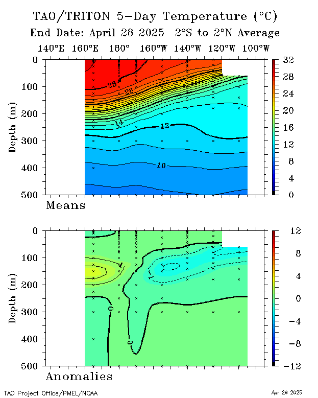
The blue colors mean cooler waters that continue to creep to the surface,meaning that the El Nino is in it's last days.
0 likes
Visit the Caribbean-Central America Weather Thread where you can find at first post web cams,radars
and observations from Caribbean basin members Click Here
and observations from Caribbean basin members Click Here
-
cycloneye
- Admin
- Posts: 149156
- Age: 69
- Joined: Thu Oct 10, 2002 10:54 am
- Location: San Juan, Puerto Rico
Re: ENSO Updates=CPC 5/3/10 update=El Nino 3.4 down to +0.5
The Australians are with the same number as Climate Prediction Center at 0.5.

0 likes
Visit the Caribbean-Central America Weather Thread where you can find at first post web cams,radars
and observations from Caribbean basin members Click Here
and observations from Caribbean basin members Click Here
I'm still not sure about the idea of La Nina, those subsurface temps don't look that agressive and we've got a slightly warm layer above the colder water as well, and the western most extent is still holding on as well to somewhat warmer waters...
All looks like classic neutral to me....however that being said the models are still keen and its hard to ignore them when they are like that!
All looks like classic neutral to me....however that being said the models are still keen and its hard to ignore them when they are like that!
0 likes
Personal Forecast Disclaimer:
The posts in this forum are NOT official forecast and should not be used as such. They are just the opinion of the poster and may or may not be backed by sound meteorological data. They are NOT endorsed by any professional institution or storm2k.org. For official information, please refer to the NHC and NWS products
The posts in this forum are NOT official forecast and should not be used as such. They are just the opinion of the poster and may or may not be backed by sound meteorological data. They are NOT endorsed by any professional institution or storm2k.org. For official information, please refer to the NHC and NWS products
-
brunota2003
- S2K Supporter
- Posts: 9476
- Age: 35
- Joined: Sat Jul 30, 2005 9:56 pm
- Location: Stanton, KY...formerly Havelock, NC
- Contact:
Certainly a dramtic swing-around compared with what we were getting in Feb/Early March with those super low readings.
0 likes
Personal Forecast Disclaimer:
The posts in this forum are NOT official forecast and should not be used as such. They are just the opinion of the poster and may or may not be backed by sound meteorological data. They are NOT endorsed by any professional institution or storm2k.org. For official information, please refer to the NHC and NWS products
The posts in this forum are NOT official forecast and should not be used as such. They are just the opinion of the poster and may or may not be backed by sound meteorological data. They are NOT endorsed by any professional institution or storm2k.org. For official information, please refer to the NHC and NWS products
-
cycloneye
- Admin
- Posts: 149156
- Age: 69
- Joined: Thu Oct 10, 2002 10:54 am
- Location: San Juan, Puerto Rico
Re: ENSO Updates
Despite comming down a little bit in the past few days,the 30 day SOI index is well in positive territory tonight's update at +13.2.
0 likes
Visit the Caribbean-Central America Weather Thread where you can find at first post web cams,radars
and observations from Caribbean basin members Click Here
and observations from Caribbean basin members Click Here
Who is online
Users browsing this forum: Google Adsense [Bot] and 149 guests