New Video by Joe Bastardi about the collapse of El Nino
Very interesting video about the demise of El Nino and implications on the upcoming hurricane season.
http://www.accuweather.com/video/830601 ... l-nino.asp
Joe Bastardi: 16-18 named storms, top 10 year
Moderator: S2k Moderators
Forum rules

The posts in this forum are NOT official forecasts and should not be used as such. They are just the opinion of the poster and may or may not be backed by sound meteorological data. They are NOT endorsed by any professional institution or STORM2K. For official information, please refer to products from the National Hurricane Center and National Weather Service.
-
cycloneye

- Admin

- Posts: 148737
- Age: 69
- Joined: Thu Oct 10, 2002 10:54 am
- Location: San Juan, Puerto Rico
Re: Joe Bastardi: More Active 2010 Hurricane Season
0 likes
Visit the Caribbean-Central America Weather Thread where you can find at first post web cams,radars
and observations from Caribbean basin members Click Here
and observations from Caribbean basin members Click Here


Re: Joe Bastardi: More Active 2010 Hurricane Season
That video is pretty scary if it holds true about a possible La Nina and the up coming hurricane season.I'm prepared and ready for mother nature. I used to watch Joe Bastardi videos when they were free which was not too long ago.
0 likes
-
Blown Away

- S2K Supporter

- Posts: 10253
- Joined: Wed May 26, 2004 6:17 am
Re: Joe Bastardi: More Active 2010 Hurricane Season
I keep thinking the predicted lower pressures in the Atlantic will lead to a weaker BH allowing more storms to recurve as fish storms. Joe B's latest diagrams indicate a strong BH funneling storms W towards the Carribean and CONUS???
Joe B says Pacific Decadal Oscillation will have the "Horseshoe of cool" how will that effect the Atlantic hurricane season??
Joe B says Pacific Decadal Oscillation will have the "Horseshoe of cool" how will that effect the Atlantic hurricane season??
0 likes
Hurricane Eye Experience: David 79, Irene 99, Frances 04, Jeanne 04, Wilma 05… Hurricane Brush Experience: Andrew 92, Erin 95, Floyd 99, Matthew 16, Irma 17, Ian 22, Nicole 22…
-
Cookie

- S2K Supporter
- Posts: 477
- Age: 37
- Joined: Sun Dec 14, 2008 11:13 am
- Location: Isle Of lewis scotland
Re: Joe Bastardi: More Active 2010 Hurricane Season
Blown Away wrote:Joe B says Pacific Decadal Oscillation will have the "Horseshoe of cool" how will that effect the Atlantic hurricane season??
what dose that mean?
0 likes

Re: Joe Bastardi: More Active 2010 Hurricane Season
Blown Away wrote:I keep thinking the predicted lower pressures in the Atlantic will lead to a weaker BH allowing more storms to recurve as fish storms. Joe B's latest diagrams indicate a strong BH funneling storms W towards the Carribean and CONUS???
Joe B says Pacific Decadal Oscillation will have the "Horseshoe of cool" how will that effect the Atlantic hurricane season??
You don't need a strong large BH, all you need is a BH say between 60W-80W and higher pressure then around it and your going to get system pushed into the Caribbean, esp if they form far enough west and then obviously be a threat to the US.
0 likes
Personal Forecast Disclaimer:
The posts in this forum are NOT official forecast and should not be used as such. They are just the opinion of the poster and may or may not be backed by sound meteorological data. They are NOT endorsed by any professional institution or storm2k.org. For official information, please refer to the NHC and NWS products
The posts in this forum are NOT official forecast and should not be used as such. They are just the opinion of the poster and may or may not be backed by sound meteorological data. They are NOT endorsed by any professional institution or storm2k.org. For official information, please refer to the NHC and NWS products
-
cycloneye
- Admin
- Posts: 148737
- Age: 69
- Joined: Thu Oct 10, 2002 10:54 am
- Location: San Juan, Puerto Rico
Re: Joe Bastardi: More Active 2010 Hurricane Season
Another Joe Bastardi Video at 5/6/10 about the 2010 Atlantic Hurricane Season
Yes,2 days in a row JB has videos and this one is more worrisom than yesterday's one.
http://www.accuweather.com/video/731462 ... -nears.asp
Yes,2 days in a row JB has videos and this one is more worrisom than yesterday's one.
http://www.accuweather.com/video/731462 ... -nears.asp
0 likes
Visit the Caribbean-Central America Weather Thread where you can find at first post web cams,radars
and observations from Caribbean basin members Click Here
and observations from Caribbean basin members Click Here
-
SkeetoBite

- S2K Supporter
- Posts: 515
- Age: 60
- Joined: Fri Sep 03, 2004 8:25 am
- Contact:

-
SETXWXLADY
- Tropical Storm

- Posts: 216
- Joined: Wed May 20, 2009 3:26 pm
- Location: SE TX Orange County
Re: Joe Bastardi: More Active 2010 Hurricane Season
Uh oh. He played the 2008 card. As far as the Bermuda high goes a weak high or negative NAO means he Bermuda high is usually positioned farther south and west. Thus bad tracks for landfalls. A strong high is usually positioned farther north and east POSITIVE NAO allows for more fish storms. I think thats what he meant on the first video. Not looking good for 2010 out there.
0 likes
-
Blown Away
- S2K Supporter
- Posts: 10253
- Joined: Wed May 26, 2004 6:17 am
Re: Joe Bastardi: More Active 2010 Hurricane Season
Looking at his illustrations he definitely has the BH south and west steering storms towards the Caribbean and CONUS. If all these things come together I think we will have some long nights on this board.
Last edited by Blown Away on Fri May 07, 2010 6:41 am, edited 1 time in total.
0 likes
Hurricane Eye Experience: David 79, Irene 99, Frances 04, Jeanne 04, Wilma 05… Hurricane Brush Experience: Andrew 92, Erin 95, Floyd 99, Matthew 16, Irma 17, Ian 22, Nicole 22…
Re:
SkeetoBite wrote:That's unusual. Joe's a bit freaked about this season and doesn't appear to have any of the hype we've seen over the past 5 years.
To be honest he doesn't need to hype this one up, all the parts are already well in play and its quite obvious to see where this season is going...
0 likes
Personal Forecast Disclaimer:
The posts in this forum are NOT official forecast and should not be used as such. They are just the opinion of the poster and may or may not be backed by sound meteorological data. They are NOT endorsed by any professional institution or storm2k.org. For official information, please refer to the NHC and NWS products
The posts in this forum are NOT official forecast and should not be used as such. They are just the opinion of the poster and may or may not be backed by sound meteorological data. They are NOT endorsed by any professional institution or storm2k.org. For official information, please refer to the NHC and NWS products
-
vbhoutex

- Storm2k Executive
- Posts: 29139
- Age: 74
- Joined: Wed Oct 09, 2002 11:31 pm
- Location: Cypress, TX
- Contact:
Re: Re:
KWT wrote:SkeetoBite wrote:That's unusual. Joe's a bit freaked about this season and doesn't appear to have any of the hype we've seen over the past 5 years.
To be honest he doesn't need to hype this one up, all the parts are already well in play and its quite obvious to see where this season is going...
Unfortunately I think you are correct about this.
0 likes
Skywarn, C.E.R.T.
Please click below to donate to STORM2K to help with the expenses of keeping the site going:

Please click below to donate to STORM2K to help with the expenses of keeping the site going:
-
wxman57

- Moderator-Pro Met

- Posts: 23122
- Age: 68
- Joined: Sat Jun 21, 2003 8:06 pm
- Location: Houston, TX (southwest)
Re: Joe Bastardi: More Active 2010 Hurricane Season
SETXWXLADY wrote:Uh oh. He played the 2008 card. As far as the Bermuda high goes a weak high or negative NAO means he Bermuda high is usually positioned farther south and west. Thus bad tracks for landfalls. A strong high is usually positioned farther north and east POSITIVE NAO allows for more fish storms. I think thats what he meant on the first video. Not looking good for 2010 out there.
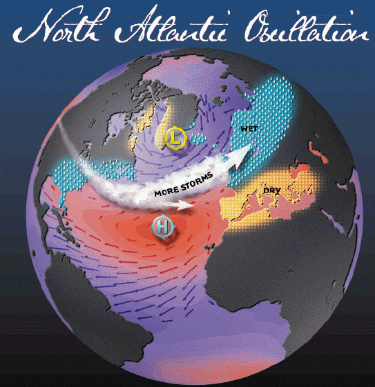
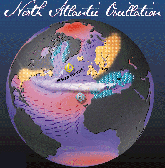
Actually, you have it backwards. A negative NAO means a deeper trof along/off the east U.S. Coast. This results in the Azores-Bermuda High center located farther north and east. The result is decreased easterly trades. This means less low-level shear in the deep tropics and less upwelling of cool water in the MDR. That's just what we're observing. Yes, with such a pattern, many, if not most of the Cape Verde storms would recurve east of the U.S. (think 1995). However, with the Caribbean and Gulf quite favorable for development, there will be some that make it through the Caribbean. This will be particularly true if something forms as the East U.S. trof is a little weaker and the high a bit farther west.
A positive NAO is what we experienced in 2009. Stronger Bermuda High, higher pressure off the East U.S. Coast (trof displaced northward), very strong trade winds, lots of dry air and dust and strong low-level shear. You can read about the NAO here. Note the graphic for a Positive NAO has a much stronger Bermuda High that is farther south and west.
http://www.ldeo.columbia.edu/res/pi/NAO/
Positive NAO (Bermuda high stronger and farther southwest):
Negative NAO (Bermuda high weaker and farther east):
0 likes

Re: Joe Bastardi: More Active 2010 Hurricane Season
After these two video's it makes me feel like packing up and moving out while I still can. 
In the meantime I'm steadily loading the new 5th wheel for the forseable hurrications in store.
In the meantime I'm steadily loading the new 5th wheel for the forseable hurrications in store.
0 likes
-
SkeetoBite
- S2K Supporter
- Posts: 515
- Age: 60
- Joined: Fri Sep 03, 2004 8:25 am
- Contact:
-
Blown Away
- S2K Supporter
- Posts: 10253
- Joined: Wed May 26, 2004 6:17 am
Re: Joe Bastardi: More Active 2010 Hurricane Season
Wxman,
You have compared 2010 to 1995, so we should expect a negative NAO for this season? When we watch JB's video, JB must be seeing a BH south and west w/ his illustrations pushing storms towards the Caribbean and CONUS??? A negative NAO and JB's predictions seem to contradict?
You have compared 2010 to 1995, so we should expect a negative NAO for this season? When we watch JB's video, JB must be seeing a BH south and west w/ his illustrations pushing storms towards the Caribbean and CONUS??? A negative NAO and JB's predictions seem to contradict?
0 likes
Hurricane Eye Experience: David 79, Irene 99, Frances 04, Jeanne 04, Wilma 05… Hurricane Brush Experience: Andrew 92, Erin 95, Floyd 99, Matthew 16, Irma 17, Ian 22, Nicole 22…
-
wxman57
- Moderator-Pro Met
- Posts: 23122
- Age: 68
- Joined: Sat Jun 21, 2003 8:06 pm
- Location: Houston, TX (southwest)
Re: Joe Bastardi: More Active 2010 Hurricane Season
Blown Away wrote:Wxman,
You have compared 2010 to 1995, so we should expect a negative NAO for this season? When we watch JB's video, JB must be seeing a BH south and west w/ his illustrations pushing storms towards the Caribbean and CONUS??? A negative NAO and JB's predictions seem to contradict?
Yes, a negative NAO is predicted by the ECMWF for this season. I've seen all JB's videos and never seen him mention the Bermuda High. He talks about SSTs and rising air in the deep tropics vs. sinking air over the cool water to the north. His analog years are the same as mine (ours). What he's not saying is that in those analog years, MOST of the Cape Verde storms recurved east of the U.S. Could be that many of the tracks cross the islands of the NE Caribbean this year, much like 1995. However, a few do make it westward (or develop farther west). And when that happens, the southeast U.S. is often hit (along with the islands of the northern Caribbean). This is the area from the MS Coast to the Mid Atlantic Coast.
The ridge that's developed over the central U.S. could be good for the NW Gulf. A secondary increased landfall threat may be the western Gulf Coast (Mexico to south TX).
JB just isn't focusing on the storms that recurve, he's concerned about the ones that develop while that east coast trof is a bit weaker. Those could threaten the U.S.
0 likes
Yeah I'm thinking much the same way Wxman57, this season looks likely to be a 16+ type season and whenever you get those sort of numbers if you don't get a big landfall somewhere, you've been very very lucky indeed.
As you say I'd imagine quite a few will recurve, esp given surface temps are so hot, could see some RI occur further east then you'd typically find which will help pull those systems northwards more often then not.
However you only need 1 or 2 of those 16+ to get through the gap and you've got possibly a horrid season.
0 likes
Personal Forecast Disclaimer:
The posts in this forum are NOT official forecast and should not be used as such. They are just the opinion of the poster and may or may not be backed by sound meteorological data. They are NOT endorsed by any professional institution or storm2k.org. For official information, please refer to the NHC and NWS products
The posts in this forum are NOT official forecast and should not be used as such. They are just the opinion of the poster and may or may not be backed by sound meteorological data. They are NOT endorsed by any professional institution or storm2k.org. For official information, please refer to the NHC and NWS products


Re: Joe Bastardi: More Active 2010 Hurricane Season
A couple of pieces of not-so-light reading, but that I think touch upon the NAO hurricane track relationship. All three of them seem to say that a negative NAO correlates with storms not recurving, but please read it for yourself and correct me if I am in error.
http://journals.ametsoc.org/doi/full/10.1175/JCLI3560.1
garnet.acns.fsu.edu/~jelsner/PDF/Research/LongLead.pdf
soundwaves.usgs.gov/2005/04/Bossakarticle.pdf
From the last work
"A weaker North Atlantic Oscillation is associated with a greater chance of major hurricane landfalls along the Gulf Coast of the U.S. [Elsner and Bossak, 2004]. Hurricanes that form off Africa and move at low latitudes to the west to make landfall on the U.S. coast south of the North Carolina border are termed straight-moving (SM) hurricanes [Elsner, 2003] and these SM hurricanes are also significantly correlated with a weaker NAO. The NAO values from May (-0.67) and June (-0.38) (These values are from 2004, I think) are moderately negative, suggesting a weakening of the NAO. The NAO has specific effects upon the Bermuda High pressure system in the Atlantic Ocean. A positive (strong) NAO results in the Bermuda High being shifted more to the east and intensifying, allowing for greater recurvature of North Atlantic hurricanes, and resulting in only an occasional landfall in the U.S. northeast [Elsner et al., 2001]. In contrast, a negative (weak) NAO allows for a more westward Bermuda High, which acts to steer North Atlantic hurricanes toward the southern U.S."
0 likes
It varies, its far too simple to term just -ve NAO as one broad thing, in truth you can have a strong subtropical belt and still have a -ve NAO, equally you can have a weaker then normal high system over the Azores/Bermuda but if the jet is lined up over Iceland then your going to get a +ve NAO.
-ve NAO tend to mean a weaker subtropical belt...and whilst the upper high may well be further west...there is more likely to be a big gap in the upper subtropical belt...because a -ve NAO usually means an amplified jet, which usually means some deep digging troughs compared to a +ve NAO.
I think therefore it depends on where a storm forms to be honest.
0 likes
Personal Forecast Disclaimer:
The posts in this forum are NOT official forecast and should not be used as such. They are just the opinion of the poster and may or may not be backed by sound meteorological data. They are NOT endorsed by any professional institution or storm2k.org. For official information, please refer to the NHC and NWS products
The posts in this forum are NOT official forecast and should not be used as such. They are just the opinion of the poster and may or may not be backed by sound meteorological data. They are NOT endorsed by any professional institution or storm2k.org. For official information, please refer to the NHC and NWS products
Who is online
Users browsing this forum: No registered users and 101 guests