BULLETIN - EAS ACTIVATION REQUESTED
TORNADO WARNING
NATIONAL WEATHER SERVICE NORMAN OK
222 PM CDT MON MAY 10 2010
THE NATIONAL WEATHER SERVICE IN NORMAN HAS ISSUED A
* TORNADO WARNING FOR...
ALFALFA COUNTY IN NORTHWEST OKLAHOMA...
NORTHWESTERN MAJOR COUNTY IN NORTHWEST OKLAHOMA...
SOUTHEASTERN WOODS COUNTY IN NORTHWEST OKLAHOMA...
EASTERN WOODWARD COUNTY IN NORTHWEST OKLAHOMA...
* UNTIL 315 PM CDT
* AT 222 PM CDT...A THUNDERSTORM CAPABLE OF PRODUCING A
TORNADO WAS LOCATED 9 MILES SOUTH OF QUINLAN...MOVING NORTHEAST
AT 55 MPH.
* LOCATIONS IN THE WARNING INCLUDE ALINE...AMORITA...BURLINGTON...
BYRON...CARMEN...CHEROKEE...DACOMA...DRIFTWOOD...GREAT SALT PLAINS
LAKE...HOPETON...INGERSOLL...JET...LAMBERT...QUINLAN...WALDRON AND
WAYNOKA.
PRECAUTIONARY/PREPAREDNESS ACTIONS...
IN ADDITION TO A TORNADO THREAT... THIS STORM LIKELY CONTAINS
DAMAGING HAIL TO THE SIZE OF BASEBALLS OR LARGER.
Next round of severe weather 7th May Onwards?
Moderator: S2k Moderators
Forum rules

The posts in this forum are NOT official forecast and should not be used as such. They are just the opinion of the poster and may or may not be backed by sound meteorological data. They are NOT endorsed by any professional institution or STORM2K.
-
Dave

- Retired Staff

- Posts: 13442
- Age: 75
- Joined: Tue Aug 01, 2006 3:57 pm
- Location: Milan Indiana
- Contact:
BULLETIN - EAS ACTIVATION REQUESTED
TORNADO WARNING
NATIONAL WEATHER SERVICE DODGE CITY KS
233 PM CDT MON MAY 10 2010
THE NATIONAL WEATHER SERVICE IN DODGE CITY HAS ISSUED A
* TORNADO WARNING FOR...
WESTERN EDWARDS COUNTY IN SOUTH CENTRAL KANSAS...
NORTHEASTERN FORD COUNTY IN SOUTHWEST KANSAS...
EXTREME SOUTHEASTERN HODGEMAN COUNTY IN SOUTHWEST KANSAS...
EXTREME NORTHWESTERN KIOWA COUNTY IN SOUTH CENTRAL KANSAS...
* UNTIL 300 PM CDT
* AT 228 PM CDT...NATIONAL WEATHER SERVICE DOPPLER RADAR INDICATED
VERY STRONG ROTATION ASSOCIATED WITH A POSSIBLE TORNADO 4 MILES
SOUTH OF WINDHORST. THIS DANGEROUS STORM WAS MOVING NORTHEAST AT 35
MPH. VERY LARGE HAIL UP TO GOLF BALL SIZE IS ALSO EXPECTED WITH
THIS STORM.
* LOCATIONS IMPACTED INCLUDE...
OFFERLE...KINSLEY AND CENTERVIEW.
0 likes

Re: Next round of severe weather 7th May Onwards?
That OK storm appears to be splitting. I've got two spots of rotation on it now.
0 likes

-
Texas Snowman

- Storm2k Moderator

- Posts: 6197
- Joined: Fri Jan 25, 2008 11:29 am
- Location: Denison, Texas
Re: Next round of severe weather 7th May Onwards?
snoopj wrote:That OK storm appears to be splitting. I've got two spots of rotation on it now.
Yeah, it appears to be doing just that. Right storm would tend to be more tornadic in a splitter, right?
0 likes
The above post and any post by Texas Snowman is NOT an official forecast and should not be used as such. It is just the opinion of the poster and may or may not be backed by sound meteorological data. It is NOT endorsed by any professional institution including storm2k.org. For official information, please refer to NWS products.
-
srainhoutx

- S2K Supporter

- Posts: 6919
- Age: 68
- Joined: Sun Jan 14, 2007 11:34 am
- Location: Haywood County, NC
- Contact:
Re: Next round of severe weather 7th May Onwards?
Texas Snowman wrote:snoopj wrote:That OK storm appears to be splitting. I've got two spots of rotation on it now.
Yeah, it appears to be doing just that. Right storm would tend to be more tornadic in a splitter, right?
Correct. The other would more likely be the hailer.
0 likes
Carla/Alicia/Jerry(In The Eye)/Michelle/Charley/Ivan/Dennis/Katrina/Rita/Wilma/Ike/Harvey
Member: National Weather Association
Wx Infinity Forums
http://wxinfinity.com/index.php
Facebook.com/WeatherInfinity
Twitter @WeatherInfinity
Member: National Weather Association
Wx Infinity Forums
http://wxinfinity.com/index.php
Facebook.com/WeatherInfinity
Twitter @WeatherInfinity
-
Dave
- Retired Staff
- Posts: 13442
- Age: 75
- Joined: Tue Aug 01, 2006 3:57 pm
- Location: Milan Indiana
- Contact:
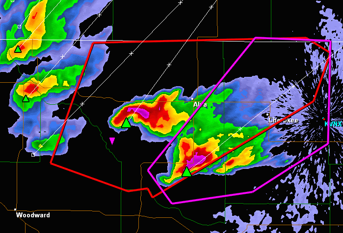
WOODS OK-ALFALFA OK-
237 PM CDT MON MAY 10 2010
...A TORNADO WARNING REMAINS IN EFFECT UNTIL 315 PM CDT FOR ALFALFA
AND SOUTHEASTERN WOODS COUNTIES...
AT 237 PM CDT...NATIONAL WEATHER SERVICE RADAR DETECTED A SEVERE
THUNDERSTORM CAPABLE OF PRODUCING A TORNADO 19 MILES SOUTHWEST OF
DACOMA...MOVING NORTHEAST AT 55 MPH.
* LOCATIONS IN THE WARNING INCLUDE ALINE...AMORITA...BURLINGTON...
BYRON...CARMEN...CHEROKEE...DACOMA...DRIFTWOOD...GREAT SALT PLAINS
LAKE...HOPETON...INGERSOLL...JET...LAMBERT AND WALDRON.
0 likes
-
Dave
- Retired Staff
- Posts: 13442
- Age: 75
- Joined: Tue Aug 01, 2006 3:57 pm
- Location: Milan Indiana
- Contact:
BULLETIN - EAS ACTIVATION REQUESTED
TORNADO WARNING
NATIONAL WEATHER SERVICE GOODLAND KS
242 PM CDT MON MAY 10 2010
THE NATIONAL WEATHER SERVICE IN GOODLAND HAS ISSUED A
* TORNADO WARNING FOR...
WESTERN GOVE COUNTY IN WEST CENTRAL KANSAS...
LOGAN COUNTY IN WEST CENTRAL KANSAS...
* UNTIL 345 PM CDT
* AT 241 PM CDT...NATIONAL WEATHER SERVICE DOPPLER RADAR INDICATED A
SEVERE THUNDERSTORM CAPABLE OF PRODUCING A TORNADO. THIS DANGEROUS
STORM WAS LOCATED 8 MILES EAST OF RUSSELL SPRINGS...AND MOVING
NORTHEAST AT 25 MPH.
* LOCATIONS IMPACTED INCLUDE...
MONUMENT...THE MONUMENT ROCKS...OAKLEY...GRINNELL AND GOVE.
PRECAUTIONARY/PREPAREDNESS ACTIONS...
TAKE COVER NOW. MOVE TO AN INTERIOR ROOM ON THE LOWEST FLOOR OF A
STURDY BUILDING. AVOID WINDOWS. IF IN A MOBILE HOME...A VEHICLE OR
OUTDOORS...MOVE TO THE CLOSEST SUBSTANTIAL SHELTER AND PROTECT
YOURSELF FROM FLYING DEBRIS.
0 likes


British team I'm watching intercepting the cell heading north of Enid...
Also yeah need to watch that right splitter very closely, the team look like they are on it though which is good.
Also yeah need to watch that right splitter very closely, the team look like they are on it though which is good.
0 likes
Personal Forecast Disclaimer:
The posts in this forum are NOT official forecast and should not be used as such. They are just the opinion of the poster and may or may not be backed by sound meteorological data. They are NOT endorsed by any professional institution or storm2k.org. For official information, please refer to the NHC and NWS products
The posts in this forum are NOT official forecast and should not be used as such. They are just the opinion of the poster and may or may not be backed by sound meteorological data. They are NOT endorsed by any professional institution or storm2k.org. For official information, please refer to the NHC and NWS products
Re: Next round of severe weather 7th May Onwards?
Last Level 2 data on the OK tornadic storm. Appears that the rotation is still elevated. Getting decent rotation between 9.5k feet and 21k feet, but nothing as pronounced on the lower tilts.
0 likes
-
Dave
- Retired Staff
- Posts: 13442
- Age: 75
- Joined: Tue Aug 01, 2006 3:57 pm
- Location: Milan Indiana
- Contact:
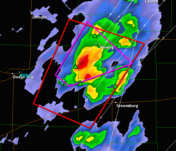
EDWARDS KS-
246 PM CDT MON MAY 10 2010
...A TORNADO WARNING REMAINS IN EFFECT FOR WESTERN EDWARDS COUNTY
UNTIL 300 PM CDT...
AT 242 PM CDT...NATIONAL WEATHER SERVICE DOPPLER RADAR INDICATED VERY
STRONG ROTATION ASSOCIATED WITH A POSSIBLE TORNADO 6 MILES SOUTH OF
OFFERLE. THIS DANGEROUS STORM WAS MOVING NORTHEAST AT 35 MPH.
LOCATIONS IMPACTED INCLUDE...
KINSLEY...
MAINLY RURAL AREAS OF WESTERN EDWARDS COUNTY
0 likes
Quite obvious to see the hook there on that OK system heading close to Alva at the moment.
0 likes
Personal Forecast Disclaimer:
The posts in this forum are NOT official forecast and should not be used as such. They are just the opinion of the poster and may or may not be backed by sound meteorological data. They are NOT endorsed by any professional institution or storm2k.org. For official information, please refer to the NHC and NWS products
The posts in this forum are NOT official forecast and should not be used as such. They are just the opinion of the poster and may or may not be backed by sound meteorological data. They are NOT endorsed by any professional institution or storm2k.org. For official information, please refer to the NHC and NWS products
-
srainhoutx
- S2K Supporter
- Posts: 6919
- Age: 68
- Joined: Sun Jan 14, 2007 11:34 am
- Location: Haywood County, NC
- Contact:
Re: Next round of severe weather 7th May Onwards?
NWS STORM PREDICTION CENTER NORMAN OK
0253 PM CDT MON MAY 10 2010
AREAS AFFECTED...PARTS OF S CNTRL/SERN KS...N CNTRL AND NE OK
CONCERNING...TORNADO WATCH 147...
VALID 101953Z - 102130Z
THE SEVERE WEATHER THREAT FOR TORNADO WATCH 147 CONTINUES.
THE RISK FOR STRONG TORNADOES APPEARS LIKELY TO INCREASE DURING THE
NEXT FEW HOURS.
THE SURFACE WARM FRONT APPEARS TO BE STRENGTHENING NEAR THE
KANSAS/OKLAHOMA BORDER AREA...AND THE DRY LINE/WARM FRONT
INTERSECTION NOW APPROACHING MEDICINE LODGE IS BECOMING THE FOCUS
FOR STRONGEST FORCING FOR UPWARD VERTICAL MOTION AND
DESTABILIZATION...AS THE EXIT REGION OF THE STRONG 500 MB JET STREAK
OVERSPREADS IT. MODELS ARE SUGGESTIVE THAT THIS BOUNDARY
INTERSECTION WILL DEVELOP EASTWARD NEAR THE STATE BORDER AREA
...SOUTH OF WICHITA/NORTH OF STILLWATER...BETWEEN NOW AND 23-00Z.
AS SURFACE DEW POINTS INCREASE THROUGH THE MID/UPPER 60S AND
LOW-LEVEL LAPSE RATES CONTINUE TO STEEPENING...IN THE PRESENCE OF
LARGE CLOCKWISE CURVED LOW-LEVEL HODOGRAPHS ACROSS THIS
REGION...POTENTIAL FOR SUPERCELLS TO PRODUCE STRONG TORNADOES
APPEARS LIKELY TO INCREASE LATE THIS AFTERNOON.
..KERR.. 05/10/2010
ATTN...WFO...TSA...ICT...OUN...DDC...
0 likes
Carla/Alicia/Jerry(In The Eye)/Michelle/Charley/Ivan/Dennis/Katrina/Rita/Wilma/Ike/Harvey
Member: National Weather Association
Wx Infinity Forums
http://wxinfinity.com/index.php
Facebook.com/WeatherInfinity
Twitter @WeatherInfinity
Member: National Weather Association
Wx Infinity Forums
http://wxinfinity.com/index.php
Facebook.com/WeatherInfinity
Twitter @WeatherInfinity
Return to “USA & Caribbean Weather”
Who is online
Users browsing this forum: HurricaneBelle and 133 guests