Next round of severe weather 7th May Onwards?
Moderator: S2k Moderators
Forum rules

The posts in this forum are NOT official forecast and should not be used as such. They are just the opinion of the poster and may or may not be backed by sound meteorological data. They are NOT endorsed by any professional institution or STORM2K.


Thats unreal CApe levels being suggested thats for sure, that being said Echo Tops suggesting the storms still aren't really punching above 40K just yet, though I suspect that won't last too much longer!
0 likes
Personal Forecast Disclaimer:
The posts in this forum are NOT official forecast and should not be used as such. They are just the opinion of the poster and may or may not be backed by sound meteorological data. They are NOT endorsed by any professional institution or storm2k.org. For official information, please refer to the NHC and NWS products
The posts in this forum are NOT official forecast and should not be used as such. They are just the opinion of the poster and may or may not be backed by sound meteorological data. They are NOT endorsed by any professional institution or storm2k.org. For official information, please refer to the NHC and NWS products
-
BlueIce
- S2K Supporter

- Posts: 194
- Age: 37
- Joined: Mon Sep 01, 2008 10:05 pm
- Location: Oklahoma City, Oklahoma
Re:
Bunkertor wrote:http://www.news9.com/ OKC - is Gary England still on duty ? I had emailed him some pictures when a F2? struck my city http://www.youtube.com/watch?v=TsgaxpQCQ2s&feature=related2006 ( tube )
Ya Gary is still here.
0 likes
-
apocalypt-flyer
- Category 1

- Posts: 468
- Joined: Sat Aug 27, 2005 11:51 am
Re:
Bunkertor wrote:http://www.news9.com/ OKC - is Gary England still on duty ? I had emailed him some pictures when a F2? struck my city [youtube]http://www.youtube.com/watch?v=TsgaxpQCQ2s&feature=related[/youtube]2006 ( tube )
Didn't it cause two fatalities as well?
'Twas one of the bigger tornado events over here in the past decade, indeed.
0 likes
-
Dave

- Retired Staff

- Posts: 13442
- Age: 75
- Joined: Tue Aug 01, 2006 3:57 pm
- Location: Milan Indiana
- Contact:
BARBER KS-
328 PM CDT MON MAY 10 2010
...A TORNADO WARNING REMAINS IN EFFECT FOR CENTRAL BARBER COUNTY
UNTIL 345 PM CDT...
AT 324 PM CDT...NATIONAL WEATHER SERVICE DOPPLER RADAR INDICATED VERY
STRONG ROTATION ASSOCIATED WITH A POSSIBLE TORNADO 5 MILES NORTHEAST
OF AETNA. THIS DANGEROUS STORM WAS MOVING NORTHEAST AT 45 MPH.
LOCATIONS IMPACTED INCLUDE...
MEDICINE LODGE...
MAINLY RURAL AREAS OF CENTRAL BARBER COUNTY.
0 likes

Re:
KWT wrote:Thats unreal CApe levels being suggested thats for sure, that being said Echo Tops suggesting the storms still aren't really punching above 40K just yet, though I suspect that won't last too much longer!
Just as you mention that, I notice that one cell is rising up to 43k (Barber Co, KS).
0 likes
-
Dave
- Retired Staff
- Posts: 13442
- Age: 75
- Joined: Tue Aug 01, 2006 3:57 pm
- Location: Milan Indiana
- Contact:
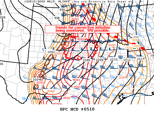
MESOSCALE DISCUSSION 0510
NWS STORM PREDICTION CENTER NORMAN OK
0328 PM CDT MON MAY 10 2010
AREAS AFFECTED...PORTIONS OF NW N-CNTRL TX
CONCERNING...SEVERE POTENTIAL...WATCH POSSIBLE
VALID 102028Z - 102130Z
TRENDS FOR CONVECTIVE INITIATION ARE BEING MONITORED. A CONDITIONAL
SEVERE THREAT EXISTS ACROSS NWRN N-CNTRL TX DEPENDENT ON WHETHER
STORMS DEVELOP. A TORNADO WATCH MAY BE REQUIRED.
RECENT SURFACE MESOANALYSIS SHOWS THE DRYLINE HAS MIXED EWD OVER THE
TX LOW ROLLING PLAINS AND IS LOCATED FROM 30 MI E CDS TO 35 MI N
BGS. TEMPS NEAR AND W OF THE DRYLINE HAVE WARMED WELL INTO THE 90S
DEG F AND HAVE RESULTED IN VERY STEEP LOW LEVEL LAPSE RATES NESTLED
ADJACENT TO A CAPPED...ALBEIT MOIST PBL /SURFACE DEWPOINTS MID-UPPER
60S DEG F/ THAT IS CHARACTERIZED AS POTENTIALLY VERY UNSTABLE
/MLCAPE AOA 3000 J/KG/. VISIBLE SATELLITE TRENDS OVER THE PAST HOUR
ARE SHOWING A DEVELOPING AREA OF CU ALONG THE DRYLINE FROM STONEWALL
TO HARDEMAN COUNTIES IN NW N-CNTRL TX.
KFDR AND KDYS VAD WIND DATA EXHIBIT SLY LOW LEVELS VEERING TO
INCREASING WSWLY TROPOSPHERIC FLOW AS AN 80 KT MID LEVEL JET CORE
PASSES JUST TO THE N OVER WRN OK. IT IS S OF THIS SPEED MAX THAT
CONVECTIVE COVERAGE REMAINS MORE UNCERTAIN WITH THE CAP STRONGER
THAN AREAS FURTHER N...BUT GRADUAL WEAKENING IS EXPECTED FROM W TO E
AS THE DRYLINE PUSHES E OVER THE REGION. CURRENT THINKING IS THE
GREATEST PROBABILITY OF ISOLD TSTMS DEVELOPING WOULD BE GENERALLY
NEAR/E OF US 183 AND POINTS E. ANY UPDRAFTS THAT BECOME
SUSTAINED...WILL LIKELY HAVE THE CAPABILITY TO RAPIDLY ORGANIZE INTO
A SUPERCELL GIVEN A STRONGLY SUPPORTIVE THERMODYNAMIC AND HIGHLY
SHEARED ENVIRONMENT. IF CONVECTIVE INITIATION APPEARS IMMINENT OR
FORTHCOMING...A TORNADO WATCH WOULD LIKELY BE REQUIRED.
..SMITH.. 05/10/2010
ATTN...WFO...FWD...OUN...SJT...
0 likes
-
Dave
- Retired Staff
- Posts: 13442
- Age: 75
- Joined: Tue Aug 01, 2006 3:57 pm
- Location: Milan Indiana
- Contact:
PRATT KS-BARBER KS-
332 PM CDT MON MAY 10 2010
...A TORNADO WARNING REMAINS IN EFFECT FOR NORTH CENTRAL BARBER AND
SOUTHEASTERN PRATT COUNTIES UNTIL 345 PM CDT...
AT 328 PM CDT...NATIONAL WEATHER SERVICE DOPPLER RADAR INDICATED VERY
STRONG ROTATION ASSOCIATED WITH A POSSIBLE TORNADO 4 MILES SOUTHEAST
OF ISABEL. THIS DANGEROUS STORM WAS MOVING NORTH AT 50 MPH.
LOCATIONS IMPACTED INCLUDE...
ISABEL...
MAINLY RURAL AREAS OF NORTHERN BARBER AND SOUTHEASTERN PRATT
COUNTIES.
0 likes

Re: Re:
apocalypt-flyer wrote:
Didn't it cause two fatalities as well?
'Twas one of the bigger tornado events over here in the past decade, indeed.
Yes, two construction workers died, because they couldn´t decend from a crane in time. The front was very well defined on the radar. That was insane.
0 likes
-
Dave
- Retired Staff
- Posts: 13442
- Age: 75
- Joined: Tue Aug 01, 2006 3:57 pm
- Location: Milan Indiana
- Contact:
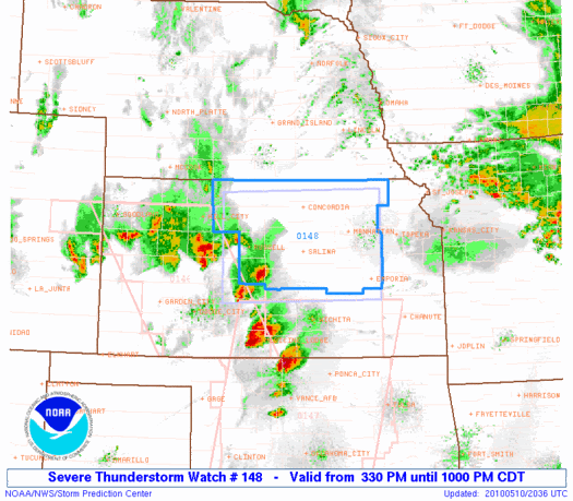
URGENT - IMMEDIATE BROADCAST REQUESTED
SEVERE THUNDERSTORM WATCH NUMBER 148
NWS STORM PREDICTION CENTER NORMAN OK
330 PM CDT MON MAY 10 2010
THE NWS STORM PREDICTION CENTER HAS ISSUED A
SEVERE THUNDERSTORM WATCH FOR PORTIONS OF
NORTH CENTRAL KANSAS
EFFECTIVE THIS MONDAY AFTERNOON AND EVENING FROM 330 PM UNTIL
1000 PM CDT.
HAIL TO 2 INCHES IN DIAMETER...THUNDERSTORM WIND GUSTS TO 70
MPH...AND DANGEROUS LIGHTNING ARE POSSIBLE IN THESE AREAS.
THE SEVERE THUNDERSTORM WATCH AREA IS APPROXIMATELY ALONG AND 65
STATUTE MILES NORTH AND SOUTH OF A LINE FROM 30 MILES WEST OF
RUSSELL KANSAS TO 40 MILES EAST SOUTHEAST OF MANHATTAN KANSAS.
FOR A COMPLETE DEPICTION OF THE WATCH SEE THE ASSOCIATED WATCH
OUTLINE UPDATE (WOUS64 KWNS WOU8).
REMEMBER...A SEVERE THUNDERSTORM WATCH MEANS CONDITIONS ARE
FAVORABLE FOR SEVERE THUNDERSTORMS IN AND CLOSE TO THE WATCH
AREA. PERSONS IN THESE AREAS SHOULD BE ON THE LOOKOUT FOR
THREATENING WEATHER CONDITIONS AND LISTEN FOR LATER STATEMENTS
AND POSSIBLE WARNINGS. SEVERE THUNDERSTORMS CAN AND OCCASIONALLY
DO PRODUCE TORNADOES.
OTHER WATCH INFORMATION...CONTINUE...WW 146...WW 147...
DISCUSSION...CLUSTERS OF STRONG/SEVERE THUNDERSTORMS WILL SPREAD
NORTHEASTWARD ACROSS NORTH CENTRAL KS THIS EVENING. ACTIVITY WILL
PRIMARILY BE ELEVATED ABOVE A RELATIVELY STABLE BOUNDARY LAYER.
HOWEVER...STEEP LAPSE RATES AND MODERATE INSTABILITY ABOVE THE
INVERSION WILL SUPPORT A RISK OF LARGE HAIL IN THE STRONGER CELLS.
AVIATION...A FEW SEVERE THUNDERSTORMS WITH HAIL SURFACE AND ALOFT
TO 2 INCHES. EXTREME TURBULENCE AND SURFACE WIND GUSTS TO 60
KNOTS. A FEW CUMULONIMBI WITH MAXIMUM TOPS TO 450. MEAN STORM
MOTION VECTOR 24035.
0 likes
Re: Re:
snoopj wrote:KWT wrote:Thats unreal CApe levels being suggested thats for sure, that being said Echo Tops suggesting the storms still aren't really punching above 40K just yet, though I suspect that won't last too much longer!
Just as you mention that, I notice that one cell is rising up to 43k (Barber Co, KS).
Yep, that storm that is now WNW of Cherokee is now over 50K, so looks like things are starting to really get going now, that cell has a pronounced hook on it as well so it looks like that could become a dangerous cell...
0 likes
Personal Forecast Disclaimer:
The posts in this forum are NOT official forecast and should not be used as such. They are just the opinion of the poster and may or may not be backed by sound meteorological data. They are NOT endorsed by any professional institution or storm2k.org. For official information, please refer to the NHC and NWS products
The posts in this forum are NOT official forecast and should not be used as such. They are just the opinion of the poster and may or may not be backed by sound meteorological data. They are NOT endorsed by any professional institution or storm2k.org. For official information, please refer to the NHC and NWS products

-
BlueIce
- S2K Supporter
- Posts: 194
- Age: 37
- Joined: Mon Sep 01, 2008 10:05 pm
- Location: Oklahoma City, Oklahoma
Re: Next round of severe weather 7th May Onwards?
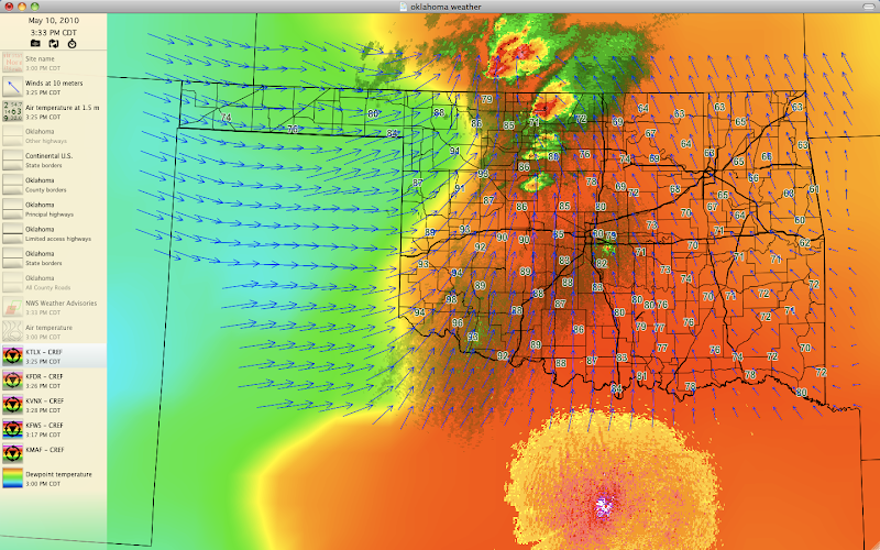
Check out the current temps in southern Oklahoma almost 100F near Altus, and the Dry line bulge is getting more pronounced in Northern Oklahoma. Dew-points are near 70F in OKC now. I am looking for storms to start forming in South Western Oklahoma at any time now.
0 likes
-
apocalypt-flyer
- Category 1
- Posts: 468
- Joined: Sat Aug 27, 2005 11:51 am
Re: Next round of severe weather 7th May Onwards?
I'm getting a set of great rotation variables SW of Wakita, OK, however, it's so close to the radar site that I can't tell if this is interference or not. Looks like it's finally developed a very distinct hook onto it.
0 likes
-
Dave
- Retired Staff
- Posts: 13442
- Age: 75
- Joined: Tue Aug 01, 2006 3:57 pm
- Location: Milan Indiana
- Contact:
BULLETIN - IMMEDIATE BROADCAST REQUESTED
SEVERE THUNDERSTORM WARNING
NATIONAL WEATHER SERVICE NORMAN OK
341 PM CDT MON MAY 10 2010
THE NATIONAL WEATHER SERVICE IN NORMAN HAS ISSUED A
* SEVERE THUNDERSTORM WARNING FOR...
NORTHWESTERN KINGFISHER COUNTY IN CENTRAL OKLAHOMA...
GARFIELD COUNTY IN NORTHERN OKLAHOMA...
SOUTHEASTERN GRANT COUNTY IN NORTHERN OKLAHOMA...
NORTHWESTERN NOBLE COUNTY IN NORTHERN OKLAHOMA...
NORTHEASTERN BLAINE COUNTY IN NORTHWEST OKLAHOMA...
SOUTHEASTERN MAJOR COUNTY IN NORTHWEST OKLAHOMA...
* UNTIL 445 PM CDT
* AT 341 PM CDT...NATIONAL WEATHER SERVICE RADAR INDICATED A SEVERE
THUNDERSTORM 17 MILES SOUTHWEST OF DRUMMOND...MOVING NORTHEAST AT
50 MPH.
HAZARDS IN THE WARNING INCLUDE...
HAIL UP TO THE SIZE OF GOLF BALLS...
WIND GUSTS TO 60 MPH...
* LOCATIONS IN THE WARNING INCLUDE BILLINGS...BISON...BRECKENRIDGE...
CERES...COVINGTON...DOUGLAS...DRUMMOND...ENID...FAIRMONT...
GARBER...HAYWARD...HUNTER...KREMLIN...LACEY...LAMONT...NORTH
ENID...POND CREEK...VANCE AIR FORCE BASE AND WAUKOMIS.
THIS INCLUDES INTERSTATE 35 BETWEEN MILE MARKERS 189 AND 204.
PRECAUTIONARY/PREPAREDNESS ACTIONS...
SEVERE THUNDERSTORMS CAN PRODUCE TORNADOES WITH NO ADVANCE WARNING.
0 likes
-
Dave
- Retired Staff
- Posts: 13442
- Age: 75
- Joined: Tue Aug 01, 2006 3:57 pm
- Location: Milan Indiana
- Contact:
ALFALFA OK-GRANT OK-
338 PM CDT MON MAY 10 2010
...A TORNADO WARNING REMAINS IN EFFECT UNTIL 400 PM CDT FOR NORTHERN
GRANT AND EASTERN ALFALFA COUNTIES...
AT 338 PM CDT...RADAR AND STORM SPOTTERS OBSERVED A TORNADO 4 MILES
SOUTHWEST OF WAKITA...MOVING NORTHEAST AT 50 MPH.
* LOCATIONS IN THE WARNING INCLUDE RENFROW AND WAKITA.
PRECAUTIONARY/PREPAREDNESS ACTIONS...
IN ADDITION TO A TORNADO THREAT... THIS STORM LIKELY CONTAINS
DAMAGING HAIL TO THE SIZE OF BASEBALLS OR LARGER.
0 likes
-
srainhoutx

- S2K Supporter
- Posts: 6919
- Age: 68
- Joined: Sun Jan 14, 2007 11:34 am
- Location: Haywood County, NC
- Contact:
Re:
CrazyC83 wrote:I'd go ahead with the tornado watch for North Texas personally. The question mark is capping, but the dynamics are INSANE there. I'd put probs like 50/50 on it.
FWD did a Special 18Z RAOB. Cap was very strong and suggests that it will be very difficult to break.
0 likes
Carla/Alicia/Jerry(In The Eye)/Michelle/Charley/Ivan/Dennis/Katrina/Rita/Wilma/Ike/Harvey
Member: National Weather Association
Wx Infinity Forums
http://wxinfinity.com/index.php
Facebook.com/WeatherInfinity
Twitter @WeatherInfinity
Member: National Weather Association
Wx Infinity Forums
http://wxinfinity.com/index.php
Facebook.com/WeatherInfinity
Twitter @WeatherInfinity
Re:
CrazyC83 wrote:I'd go ahead with the tornado watch for North Texas personally. The question mark is capping, but the dynamics are INSANE there. I'd put probs like 50/50 on it.
Temps down there now getting towards 100F near the dry line as Blueice has posted, if any lone supercells do go up, they are going to have a mega rich set-up to feed off...but that is obviously the question, do they break the cap....hmmm...
0 likes
Personal Forecast Disclaimer:
The posts in this forum are NOT official forecast and should not be used as such. They are just the opinion of the poster and may or may not be backed by sound meteorological data. They are NOT endorsed by any professional institution or storm2k.org. For official information, please refer to the NHC and NWS products
The posts in this forum are NOT official forecast and should not be used as such. They are just the opinion of the poster and may or may not be backed by sound meteorological data. They are NOT endorsed by any professional institution or storm2k.org. For official information, please refer to the NHC and NWS products
-
srainhoutx
- S2K Supporter
- Posts: 6919
- Age: 68
- Joined: Sun Jan 14, 2007 11:34 am
- Location: Haywood County, NC
- Contact:
Re: Next round of severe weather 7th May Onwards?
Looks like a debris ball near Clyde.
0 likes
Carla/Alicia/Jerry(In The Eye)/Michelle/Charley/Ivan/Dennis/Katrina/Rita/Wilma/Ike/Harvey
Member: National Weather Association
Wx Infinity Forums
http://wxinfinity.com/index.php
Facebook.com/WeatherInfinity
Twitter @WeatherInfinity
Member: National Weather Association
Wx Infinity Forums
http://wxinfinity.com/index.php
Facebook.com/WeatherInfinity
Twitter @WeatherInfinity
-
BlueIce
- S2K Supporter
- Posts: 194
- Age: 37
- Joined: Mon Sep 01, 2008 10:05 pm
- Location: Oklahoma City, Oklahoma
Re: Re:
KWT wrote:CrazyC83 wrote:I'd go ahead with the tornado watch for North Texas personally. The question mark is capping, but the dynamics are INSANE there. I'd put probs like 50/50 on it.
Temps down there now getting towards 100F near the dry line as Blueice has posted, if any lone supercells do go up, they are going to have a mega rich set-up to feed off...but that is obviously the question, do they break the cap....hmmm...
I am seeing a cell coming up 25 Miles NW of Lawton, Oklahoma.
0 likes
Return to “USA & Caribbean Weather”
Who is online
Users browsing this forum: No registered users and 208 guests