

KAY OK-GRANT OK-
357 PM CDT MON MAY 10 2010
...A TORNADO WARNING REMAINS IN EFFECT UNTIL 430 PM CDT FOR
NORTHEASTERN GRANT AND NORTHWESTERN KAY COUNTIES...
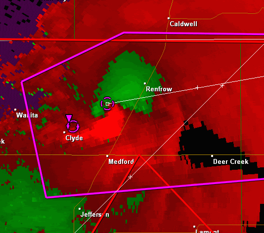
AT 356 PM CDT...A LARGE TORNADO WAS LOCATED 4 MILES NORTH
OF MEDFORD...MOVING EAST AT 55 MPH.
* LOCATIONS IN THE WARNING INCLUDE BLACKWELL LAKE...BLACKWELL...
BRAMAN...CHILOCCO...DEER CREEK...MEDFORD...NARDIN...PECKHAM AND
RENFROW.
THIS INCLUDES INTERSTATE 35 BETWEEN MILE MARKERS 221 AND 235.
PRECAUTIONARY/PREPAREDNESS ACTIONS...
IN ADDITION TO A TORNADO THREAT... THIS STORM LIKELY CONTAINS
DAMAGING HAIL TO THE SIZE OF BASEBALLS OR LARGER.
THIS IS AN EXTREMELY DANGEROUS AND LIFE THREATENING SITUATION. IF YOU
ARE IN THE PATH OF THIS LARGE TORNADO... TAKE COVER
IMMEDIATELY
Next round of severe weather 7th May Onwards?
Moderator: S2k Moderators
Forum rules

The posts in this forum are NOT official forecast and should not be used as such. They are just the opinion of the poster and may or may not be backed by sound meteorological data. They are NOT endorsed by any professional institution or STORM2K.


Re: Next round of severe weather 7th May Onwards?
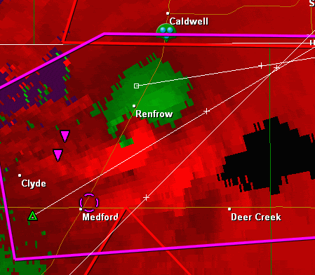
Is that a debris ball in the middle of the hook on the leading edge of the hook? Wondering if Clyde got hit?
0 likes


Re:
CrazyC83 wrote:From the KOCO chat: near Clyde, chaser reports barn damage, house damage, and a chaser unit with windows blown out
That's what worries me at the moment. I hope they aren't trying to do anything stupid around these storms.
0 likes
Re: Re:
snoopj wrote:CrazyC83 wrote:From the KOCO chat: near Clyde, chaser reports barn damage, house damage, and a chaser unit with windows blown out
That's what worries me at the moment. I hope they aren't trying to do anything stupid around these storms.
Probably a lot of newbies out there.
0 likes
-
CrazyC83
- Professional-Met

- Posts: 34315
- Joined: Tue Mar 07, 2006 11:57 pm
- Location: Deep South, for the first time!
Re: Next round of severe weather 7th May Onwards?
WWUS54 KOUN 102103
SVSOUN
SEVERE WEATHER STATEMENT
NATIONAL WEATHER SERVICE NORMAN OK
403 PM CDT MON MAY 10 2010
OKC053-071-102130-
/O.CON.KOUN.TO.W.0005.000000T0000Z-100510T2130Z/
KAY OK-GRANT OK-
403 PM CDT MON MAY 10 2010
...A TORNADO WARNING REMAINS IN EFFECT UNTIL 430 PM CDT FOR
NORTHEASTERN GRANT AND NORTHWESTERN KAY COUNTIES...
AT 402 PM CDT...A LARGE TORNADO WAS LOCATED 4 MILES
SOUTHWEST OF RENFROW...MOVING EAST AT 55 MPH.
* LOCATIONS IN THE WARNING INCLUDE BLACKWELL LAKE...BLACKWELL...
BRAMAN...CHILOCCO...DEER CREEK...MEDFORD...NARDIN...PECKHAM AND
RENFROW.
THIS INCLUDES INTERSTATE 35 BETWEEN MILE MARKERS 221 AND 235.
PRECAUTIONARY/PREPAREDNESS ACTIONS...
IN ADDITION TO A TORNADO THREAT... THIS STORM LIKELY CONTAINS
DAMAGING HAIL TO THE SIZE OF BASEBALLS OR LARGER.
THIS IS AN EXTREMELY DANGEROUS AND LIFE THREATENING SITUATION. IF YOU
ARE IN THE PATH OF THIS LARGE TORNADO... TAKE COVER
IMMEDIATELY. A BASEMENT OR STORM SHELTER IS BEST. OTHERWISE...TAKE
COVER IN AN INTERIOR CLOSET OR BATHROOM AWAY FROM OUTSIDE WALLS AND
WINDOWS. COVER YOUR HEAD WITH PILLOWS AND BLANKETS.
&&
LAT...LON 3700 9706 3679 9707 3675 9783 3694 9787
3701 9770
TIME...MOT...LOC 2102Z 254DEG 48KT 3689 9762
$$
WR
0 likes
Re: Re:
RL3AO wrote:snoopj wrote:CrazyC83 wrote:From the KOCO chat: near Clyde, chaser reports barn damage, house damage, and a chaser unit with windows blown out
That's what worries me at the moment. I hope they aren't trying to do anything stupid around these storms.
Probably a lot of newbies out there.
Not the day to be a newbie and chasing these things.
0 likes
-
CrazyC83
- Professional-Met
- Posts: 34315
- Joined: Tue Mar 07, 2006 11:57 pm
- Location: Deep South, for the first time!
Re: Re:
RL3AO wrote:snoopj wrote:CrazyC83 wrote:From the KOCO chat: near Clyde, chaser reports barn damage, house damage, and a chaser unit with windows blown out
That's what worries me at the moment. I hope they aren't trying to do anything stupid around these storms.
Probably a lot of newbies out there.
Days like this are not good times for newbies to be out there. With large, long-track and violent tornadoes likely, chasing them is best left to the experienced professionals - even them have a hard time with some.
0 likes
-
srainhoutx

- S2K Supporter

- Posts: 6919
- Age: 68
- Joined: Sun Jan 14, 2007 11:34 am
- Location: Haywood County, NC
- Contact:
Re: Next round of severe weather 7th May Onwards?
Getting concerned for areas S and W of OKC. That area looks very worrisome as the afternoon/evening progresses and moves E.
0 likes
Carla/Alicia/Jerry(In The Eye)/Michelle/Charley/Ivan/Dennis/Katrina/Rita/Wilma/Ike/Harvey
Member: National Weather Association
Wx Infinity Forums
http://wxinfinity.com/index.php
Facebook.com/WeatherInfinity
Twitter @WeatherInfinity
Member: National Weather Association
Wx Infinity Forums
http://wxinfinity.com/index.php
Facebook.com/WeatherInfinity
Twitter @WeatherInfinity

Return to “USA & Caribbean Weather”
Who is online
Users browsing this forum: AnnularCane, Greener, Ntxw, TomballEd, wxman22 and 144 guests