Next round of severe weather 7th May Onwards?

U.S. & Caribbean Weather Discussions and Severe Weather Events

Moderator: S2k Moderators

Forum rules

The posts in this forum are NOT official forecast and should not be used as such. They are just the opinion of the poster and may or may not be backed by sound meteorological data. They are NOT endorsed by any professional institution or STORM2K.

Help Support Storm2K
Message
Author
User avatar
Texas Snowman
Storm2k Moderator
Storm2k Moderator
Posts: 6151
Joined: Fri Jan 25, 2008 11:29 am
Location: Denison, Texas

Re: Next round of severe weather 7th May Onwards?

#561 Postby Texas Snowman » Mon May 10, 2010 9:13 pm

soonertwister wrote:It's just heartbreaking to hear of people losing their lives. It's still early, so I'm concerned that this might only be the beginning of some ongoing awful news.

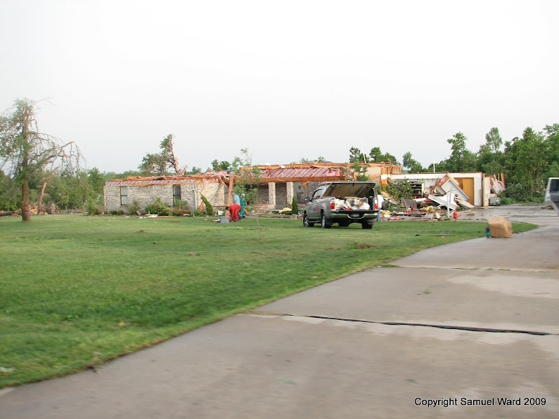
Several members of my family live within about 5 miles both north and south in between tornados that tracked across Moore and Norman. There is some incredible chaser video at this link.

http://www.weather.com/outlook/videos/r ... 7260#17259

The south Norman tornado, likely the one that also struck Tecumseh, was a certifiable monster, almost assuredly at least an EF-4.

So sad.


Agreed, that may well be an EF-4...
0 likes   
The above post and any post by Texas Snowman is NOT an official forecast and should not be used as such. It is just the opinion of the poster and may or may not be backed by sound meteorological data. It is NOT endorsed by any professional institution including storm2k.org. For official information, please refer to NWS products.

BlueIce
S2K Supporter
S2K Supporter
Posts: 194
Age: 36
Joined: Mon Sep 01, 2008 10:05 pm
Location: Oklahoma City, Oklahoma

Re: Next round of severe weather 7th May Onwards?

#562 Postby BlueIce » Mon May 10, 2010 9:14 pm

My neighborhood got hit directly by a tornado that went through south east Oklahoma City. I will post pictures soon.
0 likes   

User avatar
Texas Snowman
Storm2k Moderator
Storm2k Moderator
Posts: 6151
Joined: Fri Jan 25, 2008 11:29 am
Location: Denison, Texas

Re: Next round of severe weather 7th May Onwards?

#563 Postby Texas Snowman » Mon May 10, 2010 9:15 pm

Definite hook developing in the storm just north of Gainesville, Texas.

KXII-TV storm spotter Doug Grace reported a suspicious lowering a few minutes ago with that storm about five miles west of I-35 near Thackerville, Okla.
0 likes   
The above post and any post by Texas Snowman is NOT an official forecast and should not be used as such. It is just the opinion of the poster and may or may not be backed by sound meteorological data. It is NOT endorsed by any professional institution including storm2k.org. For official information, please refer to NWS products.

apocalypt-flyer
Category 1
Category 1
Posts: 468
Joined: Sat Aug 27, 2005 11:51 am

#564 Postby apocalypt-flyer » Mon May 10, 2010 9:18 pm

There's also something nearby Abilente, Texas that seems to try and pop up.
0 likes   

CrazyC83
Professional-Met
Professional-Met
Posts: 34001
Joined: Tue Mar 07, 2006 11:57 pm
Location: Deep South, for the first time!

#565 Postby CrazyC83 » Mon May 10, 2010 9:19 pm

Lone Grove got hit AGAIN it appears.
0 likes   

soonertwister
Category 5
Category 5
Posts: 1091
Joined: Mon Jun 16, 2003 2:52 pm

Re: Next round of severe weather 7th May Onwards?

#566 Postby soonertwister » Mon May 10, 2010 9:19 pm

Texas Snowman wrote:Definite hook developing in the storm just north of Gainesville, Texas.

KXII-TV storm spotter Doug Grace reported a suspicious lowering a few minutes ago with that storm about five miles west of I-35 near Thackerville, Okla.


That storm in particular looks like it could get very dangerous as it gets farther into the area of greatest instability.
0 likes   

User avatar
Texas Snowman
Storm2k Moderator
Storm2k Moderator
Posts: 6151
Joined: Fri Jan 25, 2008 11:29 am
Location: Denison, Texas

Re:

#567 Postby Texas Snowman » Mon May 10, 2010 9:21 pm

CrazyC83 wrote:Lone Grove got hit AGAIN it appears.


I know there was a home or two in Carter County that were hit, but that's the first I've heard that Lone Grove was actually hit.

Where did you see/hear that report?
0 likes   
The above post and any post by Texas Snowman is NOT an official forecast and should not be used as such. It is just the opinion of the poster and may or may not be backed by sound meteorological data. It is NOT endorsed by any professional institution including storm2k.org. For official information, please refer to NWS products.

Ntxwx
Tropical Storm
Tropical Storm
Posts: 153
Joined: Tue Jan 26, 2010 10:43 am
Location: Bridgeport, Texas

Re: Next round of severe weather 7th May Onwards?

#568 Postby Ntxwx » Mon May 10, 2010 9:22 pm

As the suns sets here in Decatur/Bridgeport sounds of thunder echo the atmosphere as a wall cloud sits to our north. No tornado I can see, FROM HERE.. But an ominous wall cloud with rapid lightning is still very impressive.


I take that back, now the sun has completely set and it is very dark and windy, everytime lightning strikes to the north, it reviels a lowering funnel cloud, still no touchdown but it does look more defined than earlier.
0 likes   

CrazyC83
Professional-Met
Professional-Met
Posts: 34001
Joined: Tue Mar 07, 2006 11:57 pm
Location: Deep South, for the first time!

#569 Postby CrazyC83 » Mon May 10, 2010 9:27 pm

My guess for ratings:

Moore-Choctaw: EF3

Norman-Tecumseh-Seminole: EF4
0 likes   

CrazyC83
Professional-Met
Professional-Met
Posts: 34001
Joined: Tue Mar 07, 2006 11:57 pm
Location: Deep South, for the first time!

Re: Re:

#570 Postby CrazyC83 » Mon May 10, 2010 9:28 pm

Texas Snowman wrote:
CrazyC83 wrote:Lone Grove got hit AGAIN it appears.


I know there was a home or two in Carter County that were hit, but that's the first I've heard that Lone Grove was actually hit.

Where did you see/hear that report?


Heard on KWTV.
0 likes   

CrazyC83
Professional-Met
Professional-Met
Posts: 34001
Joined: Tue Mar 07, 2006 11:57 pm
Location: Deep South, for the first time!

#571 Postby CrazyC83 » Mon May 10, 2010 9:29 pm

OKC Mayor, Red Cross, OKC Fire and Police, and Salvation Army holding a press conference at 10pm. We will stream it live.
0 likes   

BlueIce
S2K Supporter
S2K Supporter
Posts: 194
Age: 36
Joined: Mon Sep 01, 2008 10:05 pm
Location: Oklahoma City, Oklahoma

Re: Next round of severe weather 7th May Onwards?

#572 Postby BlueIce » Mon May 10, 2010 9:43 pm

0 likes   

CrazyC83
Professional-Met
Professional-Met
Posts: 34001
Joined: Tue Mar 07, 2006 11:57 pm
Location: Deep South, for the first time!

#573 Postby CrazyC83 » Mon May 10, 2010 9:56 pm

MESOSCALE DISCUSSION 0516
NWS STORM PREDICTION CENTER NORMAN OK
0951 PM CDT MON MAY 10 2010

AREAS AFFECTED...SRN-ERN OK...WRN AR...EXTREME NORTH TX

CONCERNING...TORNADO WATCH 149...150...

VALID 110251Z - 110345Z

THE SEVERE WEATHER THREAT FOR TORNADO WATCH 149...150...CONTINUES.

SCATTERED SEVERE THUNDERSTORMS...MOSTLY SUPERCELLULAR...CONTINUE
FROM NWRN AR...SWWD ACROSS OK INTO NCNTRL TX. THIS ACTIVITY
ORIGINATED WITHIN VERY UNSTABLE AIRMASS ALONG/AHEAD OF DRYLINE THAT
HAS RECENTLY STALLED. ALTHOUGH DIURNAL COOLING AND BOUNDARY LAYER
DECOUPLING SHOULD BEGIN TO IMPEDE UPDRAFT STRENGTH...VERY STRONG
SHEAR WILL LIKELY DELAY THIS PROCESS FOR SEVERAL HOURS AS INTERNAL
SUPERCELL PROCESSES ARE QUITE MATURE AND WILL TAKE SOME TIME TO
DEVOLVE. NEEDLESS TO SAY...TORNADO THREAT WILL CONTINUE UNTIL
UPDRAFTS BECOME ELEVATED AND WEAKEN.

..DARROW.. 05/11/2010


ATTN...WFO...LZK...SHV...TSA...FWD...OUN...

LAT...LON 33519773 34579562 36019389 35609337 33889458 33269672
33519773
0 likes   

User avatar
KWT
Category 5
Category 5
Posts: 31415
Joined: Tue Aug 17, 2004 11:02 am
Location: UK!!!

Re:

#574 Postby KWT » Mon May 10, 2010 10:02 pm

CrazyC83 wrote:My guess for ratings:

Moore-Choctaw: EF3

Norman-Tecumseh-Seminole: EF4


Yeah i'd go along with that from the damage I've seen.
0 likes   
Personal Forecast Disclaimer:
The posts in this forum are NOT official forecast and should not be used as such. They are just the opinion of the poster and may or may not be backed by sound meteorological data. They are NOT endorsed by any professional institution or storm2k.org. For official information, please refer to the NHC and NWS products

CrazyC83
Professional-Met
Professional-Met
Posts: 34001
Joined: Tue Mar 07, 2006 11:57 pm
Location: Deep South, for the first time!

Re: Next round of severe weather 7th May Onwards?

#575 Postby CrazyC83 » Mon May 10, 2010 10:04 pm

WWUS54 KFWD 110300
SVSFWD

SEVERE WEATHER STATEMENT
NATIONAL WEATHER SERVICE FORT WORTH TX
1000 PM CDT MON MAY 10 2010

TXC181-110330-
/O.CON.KFWD.TO.W.0011.000000T0000Z-100511T0330Z/
GRAYSON TX-
1000 PM CDT MON MAY 10 2010

...A TORNADO WARNING REMAINS IN EFFECT UNTIL 1030 PM CDT FOR NORTHERN
GRAYSON COUNTY...

AT 1000 PM CDT...STORM SPOTTERS AND DOPPLER RADAR OBSERVED A
DEVELOPING TORNADO.
THIS TORNADO WAS LOCATED NEAR KNOLLWOOD...MOVING
SOUTHEAST AT 40 MPH. STORM SPOTTERS REPORT A FUNNEL CLOUD ABOUT
HALFWAY TO THE GROUND. THIS IS A DANGEROUS STORM! SEEK SHELTER NOW!

PRECAUTIONARY/PREPAREDNESS ACTIONS...

IF YOU ARE CAUGHT OUTSIDE...SEEK SHELTER IN A REINFORCED BUILDING. AS
A LAST RESORT...LIE FLAT IN A DITCH OR LOW SPOT AND COVER YOUR HEAD.

A TORNADO WATCH REMAINS IN EFFECT UNTIL MIDNIGHT CDT TUESDAY MORNING
FOR NORTHEASTERN TEXAS.

&&

LAT...LON 3385 9661 3383 9656 3383 9651 3378 9648
3379 9644 3378 9641 3374 9637 3349 9637
3365 9681 3378 9676 3384 9671
TIME...MOT...LOC 0300Z 296DEG 34KT 3370 9661

$$
0 likes   

Siberian Express
S2K Supporter
S2K Supporter
Posts: 99
Joined: Tue Sep 27, 2005 9:13 pm
Location: Minnesota, USA

Re: Next round of severe weather 7th May Onwards?

#576 Postby Siberian Express » Mon May 10, 2010 10:08 pm

Thanks for posting those BlueIce. As bad as it looks, I think you folks just dodged a bullet. Hope everyone is OK.


BlueIce wrote:Here are photos from my neighborhood.

http://picasaweb.google.com/snward88/May10Tornado?feat=directlink

Image
0 likes   

soonertwister
Category 5
Category 5
Posts: 1091
Joined: Mon Jun 16, 2003 2:52 pm

Re: Next round of severe weather 7th May Onwards?

#577 Postby soonertwister » Mon May 10, 2010 10:12 pm

That Knollwood storm has weakened below severe limits. But two cells northeast of there both give strong evidence of being tornadic, and running along the Red River.
0 likes   

CrazyC83
Professional-Met
Professional-Met
Posts: 34001
Joined: Tue Mar 07, 2006 11:57 pm
Location: Deep South, for the first time!

#578 Postby CrazyC83 » Mon May 10, 2010 10:27 pm

One sad thing: they might have to do that all over again on Wednesday.
0 likes   

User avatar
Texas Snowman
Storm2k Moderator
Storm2k Moderator
Posts: 6151
Joined: Fri Jan 25, 2008 11:29 am
Location: Denison, Texas

Re: Next round of severe weather 7th May Onwards?

#579 Postby Texas Snowman » Mon May 10, 2010 10:29 pm

soonertwister wrote:That Knollwood storm has weakened below severe limits. But two cells northeast of there both give strong evidence of being tornadic, and running along the Red River.


Yep... just had another near miss at my home in northern Grayson County. Severe storm passed through the Sherman/Denison area in the last half-hour and it produced another tornado warning.

Storm spotters reported a wall cloud, intense rotation, and a lowering at Knollwood just north of Sherman and then a funnel cloud that was half-way to the ground east of Sherman.

First time I've actually had to herd my family into our safety closet this spring...
0 likes   
The above post and any post by Texas Snowman is NOT an official forecast and should not be used as such. It is just the opinion of the poster and may or may not be backed by sound meteorological data. It is NOT endorsed by any professional institution including storm2k.org. For official information, please refer to NWS products.

User avatar
Texas Snowman
Storm2k Moderator
Storm2k Moderator
Posts: 6151
Joined: Fri Jan 25, 2008 11:29 am
Location: Denison, Texas

#580 Postby Texas Snowman » Mon May 10, 2010 10:30 pm

One curious thing: the Pottowatomie Emergency Mgt. Director (I believe that was his title) was on one of our local TV stations a half-hour or so ago (KTEN-TV) and he disputed the report of three dead in his county...

EDIT: So there may only be two fatalities thus far in Oklahoma. I guess time will tell...

EDIT II: Found this on CNN.com. I believe Cleveland County is just west of Pottawatomie County, so that may be where the confusion resulted from: "Three people died in Cleveland County, just west of Tecumseh, said Albert Ashwood, director of the state emergency management department, and another was reported dead near Choctaw, east of Oklahoma City."
0 likes   
The above post and any post by Texas Snowman is NOT an official forecast and should not be used as such. It is just the opinion of the poster and may or may not be backed by sound meteorological data. It is NOT endorsed by any professional institution including storm2k.org. For official information, please refer to NWS products.


Return to “USA & Caribbean Weather”

Who is online

Users browsing this forum: Brent, Cpv17 and 47 guests