SE TX/SW LA weather: Much cooler and WET after Tuesday
Moderator: S2k Moderators
Forum rules

The posts in this forum are NOT official forecast and should not be used as such. They are just the opinion of the poster and may or may not be backed by sound meteorological data. They are NOT endorsed by any professional institution or STORM2K.
Re: SE TX/SW LA weather: We need rain!
I don't know if I should get a little excited but we are up to 60% Sat. through Mon. However that still leaves 40% (like me) who will not see rain.
0 likes
-
srainhoutx

- S2K Supporter

- Posts: 6919
- Age: 68
- Joined: Sun Jan 14, 2007 11:34 am
- Location: Haywood County, NC
- Contact:
Re: SE TX/SW LA weather: We need rain!
Nasty morning across Central TX. Hopefully we will see some of the activity move E over the next couple of days.
0 likes
Carla/Alicia/Jerry(In The Eye)/Michelle/Charley/Ivan/Dennis/Katrina/Rita/Wilma/Ike/Harvey
Member: National Weather Association
Wx Infinity Forums
http://wxinfinity.com/index.php
Facebook.com/WeatherInfinity
Twitter @WeatherInfinity
Member: National Weather Association
Wx Infinity Forums
http://wxinfinity.com/index.php
Facebook.com/WeatherInfinity
Twitter @WeatherInfinity
-
vbhoutex

- Storm2k Executive

- Posts: 29149
- Age: 74
- Joined: Wed Oct 09, 2002 11:31 pm
- Location: Cypress, TX
- Contact:
Re: SE TX/SW LA weather: We need rain!
srainhoutx wrote:Nasty morning across Central TX. Hopefully we will see some of the activity move E over the next couple of days.
That would be nice!! Of course we don't want the nasty part! We are bone dry in SE TX/LA.
0 likes
Skywarn, C.E.R.T.
Please click below to donate to STORM2K to help with the expenses of keeping the site going:

Please click below to donate to STORM2K to help with the expenses of keeping the site going:
-
southerngale

- Retired Staff

- Posts: 27418
- Joined: Thu Oct 10, 2002 1:27 am
- Location: Southeast Texas (Beaumont area)
 my Cowboys
 -
srainhoutx
- S2K Supporter
- Posts: 6919
- Age: 68
- Joined: Sun Jan 14, 2007 11:34 am
- Location: Haywood County, NC
- Contact:
Re: SE TX/SW LA weather: We need rain!
Finally!!
BULLETIN - EAS ACTIVATION REQUESTED
SEVERE THUNDERSTORM WARNING
NATIONAL WEATHER SERVICE HOUSTON/GALVESTON TX
435 PM CDT FRI MAY 14 2010
THE NATIONAL WEATHER SERVICE IN LEAGUE CITY HAS ISSUED A
* SEVERE THUNDERSTORM WARNING FOR...
NORTHERN BRAZOS COUNTY IN SOUTHEAST TEXAS...
NORTHWESTERN GRIMES COUNTY IN SOUTHEAST TEXAS...
WESTERN MADISON COUNTY IN SOUTHEAST TEXAS...
* UNTIL 500 PM CDT
* AT 429 PM CDT...NATIONAL WEATHER SERVICE DOPPLER RADAR INDICATED A
SEVERE THUNDERSTORM. THIS STORM WAS LOCATED 6 MILES SOUTHWEST OF
NORTH ZULCH...OR 17 MILES SOUTHWEST OF MADISONVILLE...AND MOVING
NORTH AT 25 MPH.
* LOCATIONS IN THE SEVERE THUNDERSTORM WARNING INCLUDE BUT ARE NOT
LIMITED TO IOLA AND NORMANGEE.
0 likes
Carla/Alicia/Jerry(In The Eye)/Michelle/Charley/Ivan/Dennis/Katrina/Rita/Wilma/Ike/Harvey
Member: National Weather Association
Wx Infinity Forums
http://wxinfinity.com/index.php
Facebook.com/WeatherInfinity
Twitter @WeatherInfinity
Member: National Weather Association
Wx Infinity Forums
http://wxinfinity.com/index.php
Facebook.com/WeatherInfinity
Twitter @WeatherInfinity
-
somethingfunny

- ChatStaff

- Posts: 3926
- Age: 37
- Joined: Thu May 31, 2007 10:30 pm
- Location: McKinney, Texas
Re: SE TX/SW LA weather: We need rain!
The rain is definitely coming your way this evening. I have been through it so I can tell you from experience it is indeed wet rain. 
0 likes

-
srainhoutx
- S2K Supporter
- Posts: 6919
- Age: 68
- Joined: Sun Jan 14, 2007 11:34 am
- Location: Haywood County, NC
- Contact:
Re: SE TX/SW LA weather: We need rain!
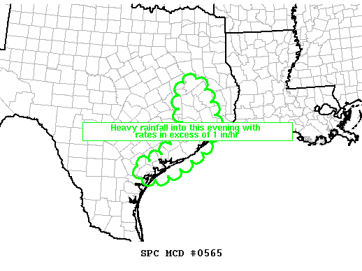
MESOSCALE DISCUSSION 0565
NWS STORM PREDICTION CENTER NORMAN OK
0602 PM CDT FRI MAY 14 2010
AREAS AFFECTED...SOUTHEAST TX AND MIDDLE/UPPER TX COAST
CONCERNING...HEAVY RAINFALL
VALID 142302Z - 150100Z
CORRIDOR OF HEAVY RAINFALL WITH RATES IN EXCESS OF 1 IN/HR WILL
SLOWLY SHIFT EAST-SOUTHEASTWARD ACROSS SOUTHEAST TX AND THE
MIDDLE/UPPER TX COAST THIS EVENING INCLUDING THE HOUSTON VICINITY.
RELATIVELY SLOW MOVING/COLD POOL-DRIVEN MCS WILL CONTINUE TO
PROPAGATE EAST-SOUTHEASTWARD ACROSS SOUTHEAST TX AND THE MIDDLE TO
UPPER TX COAST INCLUDING THE HOUSTON METRO THIS EVENING. ALONG WITH
ABOVE NORMAL PRECIPTIATABLE WATER VALUES AND RELATIVELY HIGH
MOISTURE CONTENT/PRECIPITATION EFFICIENCY WITH MEAN MIXING RATIOS IN
EXCESS OF 16 G/KG /PER 12Z LCH AND CRP OBSERVED RAOBS/...LIMITED
PROPAGATIONAL SPEED WITH LARGELY MCS-PARALLEL LOW TO MID
TROPOSPHERIC FLOW /PER WSR-88D VWP DATA/ WILL CONTINUE TO SUPPORT A
SLOW ESE MOVING CORRIDOR OF HEAVY RAINFALL WITH RATES IN EXCESS OF 1
IN/HR.
..GUYER.. 05/14/2010
ATTN...WFO...LCH...HGX...FWD...CRP...
0 likes
Carla/Alicia/Jerry(In The Eye)/Michelle/Charley/Ivan/Dennis/Katrina/Rita/Wilma/Ike/Harvey
Member: National Weather Association
Wx Infinity Forums
http://wxinfinity.com/index.php
Facebook.com/WeatherInfinity
Twitter @WeatherInfinity
Member: National Weather Association
Wx Infinity Forums
http://wxinfinity.com/index.php
Facebook.com/WeatherInfinity
Twitter @WeatherInfinity
-
srainhoutx
- S2K Supporter
- Posts: 6919
- Age: 68
- Joined: Sun Jan 14, 2007 11:34 am
- Location: Haywood County, NC
- Contact:
Re: SE TX/SW LA weather: We need rain!
FLOOD ADVISORY
NATIONAL WEATHER SERVICE HOUSTON/GALVESTON TX
637 PM CDT FRI MAY 14 2010
TXC157-201-150130-
/O.NEW.KHGX.FA.Y.0010.100514T2337Z-100515T0130Z/
/00000.N.ER.000000T0000Z.000000T0000Z.000000T0000Z.OO/
HARRIS TX-FORT BEND TX-
637 PM CDT FRI MAY 14 2010
THE NATIONAL WEATHER SERVICE IN LEAGUE CITY HAS ISSUED AN
* URBAN AND SMALL STREAM FLOOD ADVISORY FOR...
NORTHEASTERN FORT BEND COUNTY IN SOUTHEAST TEXAS...
HARRIS COUNTY IN SOUTHEAST TEXAS...
* UNTIL 830 PM CDT
* AT 633 PM CDT...NATIONAL WEATHER SERVICE DOPPLER RADAR INDICATED A
SLOW MOVING BAND OF VERY HEAVY RAINFALL ACROSS WEST CENTRAL
PORTIONS OF HARRIS COUNTY AND EXTENDING SOUTHWEST ACROSS FORT
BEND COUNTY. 2 TO 3 INCH HOURLY RAINFALL RATES ARE OCCURRING
IN THE STRONGEST STORMS IN THE BAND. ISOLATED AMOUNTS OF 3 TO 4
INCHES ARE POSSIBLE IN THE NEXT TWO HOURS.
0 likes
Carla/Alicia/Jerry(In The Eye)/Michelle/Charley/Ivan/Dennis/Katrina/Rita/Wilma/Ike/Harvey
Member: National Weather Association
Wx Infinity Forums
http://wxinfinity.com/index.php
Facebook.com/WeatherInfinity
Twitter @WeatherInfinity
Member: National Weather Association
Wx Infinity Forums
http://wxinfinity.com/index.php
Facebook.com/WeatherInfinity
Twitter @WeatherInfinity
-
vbhoutex
- Storm2k Executive
- Posts: 29149
- Age: 74
- Joined: Wed Oct 09, 2002 11:31 pm
- Location: Cypress, TX
- Contact:
Re: SE TX/SW LA weather: We need rain!
Definitely been getting some good heavy rain here in Spring Branch area, but nothing severe yet. No flooding yet either.
0 likes
Skywarn, C.E.R.T.
Please click below to donate to STORM2K to help with the expenses of keeping the site going:
Please click below to donate to STORM2K to help with the expenses of keeping the site going:
-
vbhoutex
- Storm2k Executive
- Posts: 29149
- Age: 74
- Joined: Wed Oct 09, 2002 11:31 pm
- Location: Cypress, TX
- Contact:
Re: SE TX/SW LA weather: We need rain!
It has let up some here, but looking at radar I don't see it stopping any time soon. This system is moving very slowly east so we are getting some training as the storms within the system are NNE. Will need to watch it for sure. I have a meeting to go to at 8:45 too. 
0 likes
Skywarn, C.E.R.T.
Please click below to donate to STORM2K to help with the expenses of keeping the site going:
Please click below to donate to STORM2K to help with the expenses of keeping the site going:
-
srainhoutx
- S2K Supporter
- Posts: 6919
- Age: 68
- Joined: Sun Jan 14, 2007 11:34 am
- Location: Haywood County, NC
- Contact:
Re:
JenBayles wrote:For the last 30 minutes or so the "red blob" over downtown Houston has been moving from east to west. is that a little low forming on the line?
This meso has been spinning all day Jen. The Meso Low does appear to be near Central Harris County.
0 likes
Carla/Alicia/Jerry(In The Eye)/Michelle/Charley/Ivan/Dennis/Katrina/Rita/Wilma/Ike/Harvey
Member: National Weather Association
Wx Infinity Forums
http://wxinfinity.com/index.php
Facebook.com/WeatherInfinity
Twitter @WeatherInfinity
Member: National Weather Association
Wx Infinity Forums
http://wxinfinity.com/index.php
Facebook.com/WeatherInfinity
Twitter @WeatherInfinity
-
JenBayles

- Category 5

- Posts: 3461
- Age: 63
- Joined: Tue Aug 26, 2003 3:27 pm
- Location: Houston, TX
- Contact:
FLASH FLOOD WARNING
TXC157-150230-
/O.NEW.KHGX.FF.W.0003.100515T0029Z-100515T0230Z/
/00000.0.ER.000000T0000Z.000000T0000Z.000000T0000Z.OO/
BULLETIN - EAS ACTIVATION REQUESTED
FLASH FLOOD WARNING
NATIONAL WEATHER SERVICE HOUSTON/GALVESTON TX
729 PM CDT FRI MAY 14 2010
THE NATIONAL WEATHER SERVICE IN LEAGUE CITY HAS ISSUED A
* FLASH FLOOD WARNING FOR...
FORT BEND COUNTY IN SOUTHEAST TEXAS...
* UNTIL 930 PM CDT
* AT 713 PM CDT...NATIONAL WEATHER SERVICE DOPPLER RADAR INDICATED
THAT FLASH FLOODING WAS LIKELY FROM A BAND OF STRONG THUNDERSTORMS
LOCATED ACROSS CENTRAL PORTIONS OF THE COUNTY. RADAR ESTIMATES INDICATE
THAT 3 TO 5 INCHES OF RAIN HAS FALLEN OVER THE PAST 3 HOURS WITH
ANOTHER 1 TO 2 INCHES LIKELY.
* LOCATIONS IN THE FLOOD WARNING INCLUDE BUT ARE NOT LIMITED TO TOWN
WEST...THOMPSONS...SUGAR LAND...STAFFORD...RICHMOND...PLEAK...PECAN
GROVE...NEEDVILLE...MISSION BEND...MEADOWS...FULSHEAR...FIRST
COLONY AND BEASLEY.
0 likes
-
Yankeegirl

- Category 5
- Posts: 3417
- Age: 50
- Joined: Sun May 23, 2004 11:59 pm
- Location: Cy-Fair, Northwest Houston
- Contact:
Re: SE TX/SW LA weather: We need rain!
Pretty much over here as of now, still lightning a ton to the south of me, kinda in your direction Jen!! Im not sure how much rain we ended up with, but it was a good amount, my empty flowerbeds are flooded....
0 likes
-
srainhoutx
- S2K Supporter
- Posts: 6919
- Age: 68
- Joined: Sun Jan 14, 2007 11:34 am
- Location: Haywood County, NC
- Contact:
Re: SE TX/SW LA weather: We need rain!
BULLETIN - EAS ACTIVATION REQUESTED
FLASH FLOOD WARNING
NATIONAL WEATHER SERVICE HOUSTON/GALVESTON TX
758 PM CDT FRI MAY 14 2010
THE NATIONAL WEATHER SERVICE IN LEAGUE CITY HAS ISSUED A
* FLASH FLOOD WARNING FOR...
HARRIS COUNTY IN SOUTHEAST TEXAS...
* UNTIL 945 PM CDT
* AT 745 PM CDT...NATIONAL WEATHER SERVICE DOPPLER RADAR INDICATED
THAT FLASH FLOODING WAS LIKELY FROM A CLUSTER OF SLOW MOVING STRONG
THUNDERSTORMS. DOPPLER RADAR ESTIMATES INDICATE THAT BETWEEN 2
AND 4 INCHES OF RAIN HAVE FALLEN ACROSS AREAS BETWEEN THE CITY
OF HOUSTON AND ALDINE NEAR I-45 AND ALONG I-10 BETWEEN
BELTWAY 8 AND KATY AND ALSO IN THE SUGARLAND AREA AND SOUTHWEST
HOUSTON.
* LOCATIONS IN THE FLOOD WARNING INCLUDE BUT ARE NOT LIMITED TO THE
MEDICAL CENTER...SPLASHTOWN...RELIANT PARK...MINUTE MAID PARK...
MEMORIAL...HOOKS AIRPORT...HOBBY AIRPORT...HERMAN PARK...THE
GALLERIA...BUSH-INTERCONTINENTAL AIRPORT...ADDICKS...WEST
UNIVERSITY PLACE...TOMBALL...SPRING VALLEY...SPRING...SOUTHSIDE
PLACE...PINEY POINT VILLAGE...KATY...JERSEY VILLAGE...JACINTO
CITY...HUNTERS CREEK VILLAGE...HUMBLE...HOUSTON...HILSHIRE
VILLAGE...HEDWIG VILLAGE...GALENA PARK...BUNKER HILL VILLAGE AND
BELLAIRE.
0 likes
Carla/Alicia/Jerry(In The Eye)/Michelle/Charley/Ivan/Dennis/Katrina/Rita/Wilma/Ike/Harvey
Member: National Weather Association
Wx Infinity Forums
http://wxinfinity.com/index.php
Facebook.com/WeatherInfinity
Twitter @WeatherInfinity
Member: National Weather Association
Wx Infinity Forums
http://wxinfinity.com/index.php
Facebook.com/WeatherInfinity
Twitter @WeatherInfinity
Return to “USA & Caribbean Weather”
Who is online
Users browsing this forum: No registered users and 151 guests