Big change for tomorrow - derecho perhaps?
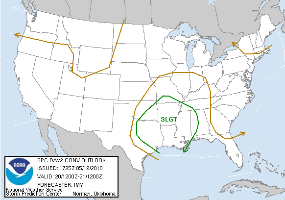
SPC AC 191725
DAY 2 CONVECTIVE OUTLOOK
NWS STORM PREDICTION CENTER NORMAN OK
1225 PM CDT WED MAY 19 2010
VALID 201200Z - 211200Z
...THERE IS A SLGT RISK OF SVR TSTMS FROM ERN TX/OK EWD ACROSS
AR/LA/MS AND INTO WRN AL/TN...
...SYNOPSIS...
AN UPPER LEVEL TROUGH FROM NEB/KS SWD INTO CENTRAL TX AT DAYBREAK IS
FORECAST TO EJECT SLIGHTLY NEGATIVELY-TILTED ACROSS THE LOWER/MS
VALLEY...AS A STRONG UPPER TROUGH DEEPENS AND MOVES EWD ACROSS THE
WRN STATES. MODELS ONLY SUGGEST A WEAK SURFACE TROUGH WILL BE
ASSOCIATED WITH UPPER TROUGH...WITH A MINOR SURFACE LOW LOCATED IN
WRN MO AND TRAILING SURFACE FRONT/TROUGH EXTENDING SWWD INTO NRN TX.
ALSO...WHILE THE SYNOPTIC WARM FRONT MAY BE IN MO...MORNING
CONVECTION IS LIKELY TO MAINTAIN A SUBTLE WARM FRONT FROM THE
ARKLATEX REGION SEWD INTO SRN AL DURING THE DAY THU.
...ERN TX/OK EWD ACROSS AR/LA/MS AND INTO WRN TN/AL...
SEVERE EVOLUTION ON THU WILL BE COMPLICATED BY WIDESPREAD CONVECTION
THAT IS EXPECTED TO BE ONGOING AT 12Z FROM MO/AR SWWD INTO SERN
OK/NRN TX. ALTHOUGH THE UPDRAFTS MAY BE SLIGHTLY DECOUPLED FROM
BOUNDARY LAYER...SHEAR AND INSTABILITY WILL BE FAVORABLE FOR THESE
STORMS TO BE SEVERE ACROSS AR...WRN TN...SERN OK AND NRN TX DURING
THE MORNING. PRIMARY THREAT SHOULD BE WIND DAMAGE AS CONGEALED
DOWNDRAFTS SHOULD HAVE CONSOLIDATED STORMS INTO ONE OR MORE MCS/S.
HOWEVER...WIND PROFILES/MODERATE INSTABILITY MAY ALSO SUPPORT AN
ISOLATED TORNADO AND SEVERE HAIL THREAT.
NAM/GFS SHOW DIFFERENT EVOLUTION OF CONVECTIVE PCPN ON THU. NAM HAS
BEEN CONSISTENT IN MORNING STORMS BEING MAINTAINED AND INTENSIFYING
AS A FORWARD PROPAGATING QLCS FROM THE ARKLATEX ESEWD ALONG BOUNDARY
INTO MS DURING THE AFTERNOON. THIS SOLUTION APPEARS MOST REASONABLE
GIVEN THE STRONG FORCING SPREADING EWD IN ASSOCIATION WITH THE UPPER
TROUGH. THE STRONG INSTABILITY AND FORECAST LINE MOTION AT 40-50 KT
WOULD BE VERY SUPPORTIVE OF DAMAGING WINDS...SOME WHICH COULD BE
SIGNIFICANT. ADDITIONALLY... THE LOW/DEEP LAYER SHEAR WOULD SUPPORT
TORNADOES WITHIN EMBEDDED BOWS. IF THIS SCENARIO APPEARS
LIKELY...PORTIONS OF AREA MAY BE UPGRADED TO A MODERATE RISK ON
UPCOMING DAY 1 OUTLOOKS.
FURTHER WEST ACROSS ERN OK AND NRN TX...AFTER MORNING CONVECTION
SHIFTS EAST OF THE AREA...PARTY CLOUDY SKIES SHOULD ALLOW
TEMPERATURES TO WARM INTO THE UPPER 70S AND 80S. THESE READINGS PLUS
THE MOIST BOUNDARY LAYER...EAST OF SURFACE TROUGH...WILL RESULT IN
MLCAPE VALUES FROM 2000-3000 J/KG. WEAK CONVERGENCE AND POSSIBLE
SUBSIDENCE BEHIND MCS OVER THE LOWER MS VALLEY MAY LIMIT STORM
COVERAGE. HOWEVER...MID LEVEL SPEED MAX COMBINED WITH STRONG
INSTABILITY AND 40-50 KT DEEP LAYER SHEAR WOULD SUPPORT AT LEAST
ISOLATED INTENSE SUPERCELLS BY LATE AFTERNOON. WHILE THE DEGREE OF
SHEAR AND VERY MOIST BOUNDARY LAYER MIGHT SUPPORT A TORNADO OR
TWO...RELATIVELY WEAK WINDS FROM THE SURFACE-700 MB SUGGEST THAT
VERY LARGE HAIL AND WIND DAMAGE WOULD BE THE PRIMARY THREATS WITH
THESE STORMS.
..IMY.. 05/19/2010
CLICK TO GET WUUS02 PTSDY2 PRODUCT
NOTE: THE NEXT DAY 2 OUTLOOK IS SCHEDULED BY 0600Z
CURRENT UTC TIME: 1822Z (2:22PM), RELOAD THIS PAGE TO UPDATE THE TIME
Tornado and Severe Weather Outbreak May 18-20
Moderator: S2k Moderators
Forum rules

The posts in this forum are NOT official forecast and should not be used as such. They are just the opinion of the poster and may or may not be backed by sound meteorological data. They are NOT endorsed by any professional institution or STORM2K.
-
CrazyC83
- Professional-Met

- Posts: 34315
- Joined: Tue Mar 07, 2006 11:57 pm
- Location: Deep South, for the first time!
Re: Moderate Risk for North Texas 5-19
Look for a PDS watch shortly.
MESOSCALE DISCUSSION 0623
NWS STORM PREDICTION CENTER NORMAN OK
0122 PM CDT WED MAY 19 2010
AREAS AFFECTED...OK AND EXTREME NRN TX
CONCERNING...SEVERE POTENTIAL...WATCH LIKELY
VALID 191822Z - 192015Z
MID-LVL SHORTWAVE RIDGING IN WAKE OF THE MORNING MCS WAS BEGINNING
TO MIGRATE INTO ERN OK AND ACCELERATED COOLING ALOFT IS EXPECTED TO
SPREAD EWD THROUGH THE NEXT FEW HOURS. 18Z VSBL SATL ALREADY SHOWS
EVIDENCE OF TCU INVOF THE TRIPLE POINT OVER ERN HEMPHILL/WHEELER
COUNTIES IN THE TX PNHDL AND MAY MARK THE BEGINNING OF AN ACTIVE
MID-LATE AFTN/EVENING DOWNSTREAM.
18Z MESOANALYSIS DEPICTS AN OUTFLOW BOUNDARY VERY NEAR I-40 WITH A
WRMFNT EXTENDING ESE FROM THE TRIPLE POINT ACROSS NORMAN TO SERN OK.
A PRE-FRONTAL TROUGH SEEMINGLY HAS EVOLVED AND WAS LOCATED A COUPLE
ROWS OF COUNTIES W OF I-44...WELL-AHEAD OF THE DRYLINE. TO THE W OF
THIS FEATURE...CU FIELD WAS INCREASING AND STRATUS WAS ERODING TO
THE N OF THE OUTFLOW BOUNDARY FROM ABOUT EL RENO WWD TO THE STATE
LINE.
AS THE SFC LOW BEGINS TO DEEPEN THIS AFTN...EXPECT THAT THE SFC-H85
FLOW WILL BACK SOMEWHAT AND MAINTAIN SUFFICIENT CONVERGENCE ALONG
THE DRYLINE TO SUPPORT TSTM INITIATION IN THE 19-21Z TIME
FRAME...PERHAPS EVOLVING FROM CURRENT BUILD-UPS ENTERING WCNTRL OK.
OTHER STORMS MAY ALSO INITIATE EWD ALONG THE OUTFLOW OR EVEN PERHAPS
THE PRE-FRONTAL TROUGH FROM OKC METRO WWD ALONG/JUST N OF I-40 AFTER
21Z. MATURE STORMS WILL TRACK ROUGHLY 250/30 KTS.
INGREDIENTS ARE BEGINNING TO CONGEAL FOR THE POSSIBILITY OF STRONG
TORNADOES FROM N OF KCSM ESE THROUGH KOKC METRO IN THE 21Z-02Z AND
POSSIBLY FARTHER ESE INTO ECNTRL OK BY MID-EVENING. HERE...0-1KM
SRH WILL GENERALLY BE 250-300 M2/S2 AMIDST LOW LCL/S AND A HIGH
PROBABILITY FOR DISCRETE STORMS. OTHERWISE...VERY LARGE HAIL AND
DMGG WIND GUSTS CAN ALSO BE EXPECTED.
..RACY.. 05/19/2010
ATTN...WFO...SHV...TSA...FWD...OUN...
LAT...LON 36249762 35909482 34089459 33529703 34249867 34939956
35939997 36249762
0 likes
-
srainhoutx

- S2K Supporter

- Posts: 6919
- Age: 68
- Joined: Sun Jan 14, 2007 11:34 am
- Location: Haywood County, NC
- Contact:
Re: Moderate Risk for North Texas 5-19
CrazyC83 wrote:Big change for tomorrow - derecho perhaps?
SPC AC 191725
DAY 2 CONVECTIVE OUTLOOK
NWS STORM PREDICTION CENTER NORMAN OK
1225 PM CDT WED MAY 19 2010
VALID 201200Z - 211200Z
...THERE IS A SLGT RISK OF SVR TSTMS FROM ERN TX/OK EWD ACROSS
AR/LA/MS AND INTO WRN AL/TN...
...SYNOPSIS...
AN UPPER LEVEL TROUGH FROM NEB/KS SWD INTO CENTRAL TX AT DAYBREAK IS
FORECAST TO EJECT SLIGHTLY NEGATIVELY-TILTED ACROSS THE LOWER/MS
VALLEY...AS A STRONG UPPER TROUGH DEEPENS AND MOVES EWD ACROSS THE
WRN STATES. MODELS ONLY SUGGEST A WEAK SURFACE TROUGH WILL BE
ASSOCIATED WITH UPPER TROUGH...WITH A MINOR SURFACE LOW LOCATED IN
WRN MO AND TRAILING SURFACE FRONT/TROUGH EXTENDING SWWD INTO NRN TX.
ALSO...WHILE THE SYNOPTIC WARM FRONT MAY BE IN MO...MORNING
CONVECTION IS LIKELY TO MAINTAIN A SUBTLE WARM FRONT FROM THE
ARKLATEX REGION SEWD INTO SRN AL DURING THE DAY THU.
...ERN TX/OK EWD ACROSS AR/LA/MS AND INTO WRN TN/AL...
SEVERE EVOLUTION ON THU WILL BE COMPLICATED BY WIDESPREAD CONVECTION
THAT IS EXPECTED TO BE ONGOING AT 12Z FROM MO/AR SWWD INTO SERN
OK/NRN TX. ALTHOUGH THE UPDRAFTS MAY BE SLIGHTLY DECOUPLED FROM
BOUNDARY LAYER...SHEAR AND INSTABILITY WILL BE FAVORABLE FOR THESE
STORMS TO BE SEVERE ACROSS AR...WRN TN...SERN OK AND NRN TX DURING
THE MORNING. PRIMARY THREAT SHOULD BE WIND DAMAGE AS CONGEALED
DOWNDRAFTS SHOULD HAVE CONSOLIDATED STORMS INTO ONE OR MORE MCS/S.
HOWEVER...WIND PROFILES/MODERATE INSTABILITY MAY ALSO SUPPORT AN
ISOLATED TORNADO AND SEVERE HAIL THREAT.
NAM/GFS SHOW DIFFERENT EVOLUTION OF CONVECTIVE PCPN ON THU. NAM HAS
BEEN CONSISTENT IN MORNING STORMS BEING MAINTAINED AND INTENSIFYING
AS A FORWARD PROPAGATING QLCS FROM THE ARKLATEX ESEWD ALONG BOUNDARY
INTO MS DURING THE AFTERNOON. THIS SOLUTION APPEARS MOST REASONABLE
GIVEN THE STRONG FORCING SPREADING EWD IN ASSOCIATION WITH THE UPPER
TROUGH. THE STRONG INSTABILITY AND FORECAST LINE MOTION AT 40-50 KT
WOULD BE VERY SUPPORTIVE OF DAMAGING WINDS...SOME WHICH COULD BE
SIGNIFICANT. ADDITIONALLY... THE LOW/DEEP LAYER SHEAR WOULD SUPPORT
TORNADOES WITHIN EMBEDDED BOWS. IF THIS SCENARIO APPEARS
LIKELY...PORTIONS OF AREA MAY BE UPGRADED TO A MODERATE RISK ON
UPCOMING DAY 1 OUTLOOKS.
FURTHER WEST ACROSS ERN OK AND NRN TX...AFTER MORNING CONVECTION
SHIFTS EAST OF THE AREA...PARTY CLOUDY SKIES SHOULD ALLOW
TEMPERATURES TO WARM INTO THE UPPER 70S AND 80S. THESE READINGS PLUS
THE MOIST BOUNDARY LAYER...EAST OF SURFACE TROUGH...WILL RESULT IN
MLCAPE VALUES FROM 2000-3000 J/KG. WEAK CONVERGENCE AND POSSIBLE
SUBSIDENCE BEHIND MCS OVER THE LOWER MS VALLEY MAY LIMIT STORM
COVERAGE. HOWEVER...MID LEVEL SPEED MAX COMBINED WITH STRONG
INSTABILITY AND 40-50 KT DEEP LAYER SHEAR WOULD SUPPORT AT LEAST
ISOLATED INTENSE SUPERCELLS BY LATE AFTERNOON. WHILE THE DEGREE OF
SHEAR AND VERY MOIST BOUNDARY LAYER MIGHT SUPPORT A TORNADO OR
TWO...RELATIVELY WEAK WINDS FROM THE SURFACE-700 MB SUGGEST THAT
VERY LARGE HAIL AND WIND DAMAGE WOULD BE THE PRIMARY THREATS WITH
THESE STORMS.
..IMY.. 05/19/2010
CLICK TO GET WUUS02 PTSDY2 PRODUCT
NOTE: THE NEXT DAY 2 OUTLOOK IS SCHEDULED BY 0600Z
CURRENT UTC TIME: 1822Z (2:22PM), RELOAD THIS PAGE TO UPDATE THE TIME
0 likes
Carla/Alicia/Jerry(In The Eye)/Michelle/Charley/Ivan/Dennis/Katrina/Rita/Wilma/Ike/Harvey
Member: National Weather Association
Wx Infinity Forums
http://wxinfinity.com/index.php
Facebook.com/WeatherInfinity
Twitter @WeatherInfinity
Member: National Weather Association
Wx Infinity Forums
http://wxinfinity.com/index.php
Facebook.com/WeatherInfinity
Twitter @WeatherInfinity
-
thetruesms

- Professional-Met
- Posts: 844
- Age: 42
- Joined: Thu Aug 16, 2007 1:14 pm
- Location: Tallahasee, FL
- Contact:
Re: Moderate Risk for North Texas 5-19
Perhaps, but looking at SREF for tomorrow, it doesn't seem like support for a derecho is going to be very strong in the new slight area. It seems more just like the environment may be better suited to maintain the overnight MCSsCrazyC83 wrote:Big change for tomorrow - derecho perhaps?
0 likes


Interesting to see they've gone for a high risk with this one, it certainly does need watching though I'd say this was a 'lower' end high risk, IE not quite a shoe-in...
Still going to need very close watching IMO!
Still going to need very close watching IMO!
0 likes
Personal Forecast Disclaimer:
The posts in this forum are NOT official forecast and should not be used as such. They are just the opinion of the poster and may or may not be backed by sound meteorological data. They are NOT endorsed by any professional institution or storm2k.org. For official information, please refer to the NHC and NWS products
The posts in this forum are NOT official forecast and should not be used as such. They are just the opinion of the poster and may or may not be backed by sound meteorological data. They are NOT endorsed by any professional institution or storm2k.org. For official information, please refer to the NHC and NWS products
-
CrazyC83
- Professional-Met
- Posts: 34315
- Joined: Tue Mar 07, 2006 11:57 pm
- Location: Deep South, for the first time!
Re: Moderate Risk for North Texas 5-19
Current conditions in the threat area - 2:00 pm CDT (Red - city in MDT, purple - city in HIGH)
Arkansas
DeQueen - Partly cloudy, 78 (67)
Fayetteville - Mostly cloudy, 62 (58)
Fort Smith - Partly cloudy, 74 (58)
Mena - Mostly cloudy, 72 (61)
Texarkana - Mostly cloudy, 81 (67)
Kansas
Chaunte - Thunderstorm, 57 (55)
Dodge City - Light rain, 57 (55)
Garden City - Light rain, 61 (57)
Medicine Lodge - Overcast, 62 (60)
Wichita - Overcast, 63 (59)
Oklahoma
Altus - A few clouds, 83 (66)
Ardmore - Mostly cloudy, 81 (66)
Bartlesville - Overcast, 62 (58)
Clinton - A few clouds, 82 (61)
Enid - Fog, 63 (63)
Lawton - A few clouds, 83 (66)
McAlester - Mostly cloudy, 75 (65)
Muskogee - Partly cloudy, 72 (61)
Oklahoma City - Partly cloudy, 72 (67)
Stillwater - Mostly cloudy, 65 (61)
Tulsa - Mostly cloudy, 66 (58)
Woodward - Mostly cloudy, 68 (62)
Texas
Abilene - Clear, 83 (64)
Dallas - A few clouds, 83 (66)
Fort Worth - Partly cloudy, 86 (67)
Paris - Mostly cloudy, 82 (72)
Sherman - Mostly cloudy, 82 (67)
Tyler - A few clouds, 89 (66)
Waco - A few clouds, 88 (66)
Wichita Falls - Partly cloudy, 83 (66)
0 likes
-
srainhoutx
- S2K Supporter
- Posts: 6919
- Age: 68
- Joined: Sun Jan 14, 2007 11:34 am
- Location: Haywood County, NC
- Contact:
Re:
CrazyC83 wrote:New watch coming out for most of Oklahoma. Should be PDS.
Watch 190 is a PDS.
0 likes
Carla/Alicia/Jerry(In The Eye)/Michelle/Charley/Ivan/Dennis/Katrina/Rita/Wilma/Ike/Harvey
Member: National Weather Association
Wx Infinity Forums
http://wxinfinity.com/index.php
Facebook.com/WeatherInfinity
Twitter @WeatherInfinity
Member: National Weather Association
Wx Infinity Forums
http://wxinfinity.com/index.php
Facebook.com/WeatherInfinity
Twitter @WeatherInfinity
-
CrazyC83
- Professional-Met
- Posts: 34315
- Joined: Tue Mar 07, 2006 11:57 pm
- Location: Deep South, for the first time!
Re: Re:
srainhoutx wrote:CrazyC83 wrote:New watch coming out for most of Oklahoma. Should be PDS.
Watch 190 is a PDS.Good call CrazyC83!
Considering that is in a high risk area, I would have been SHOCKED if it wasn't. Just waiting for the full text, it doesn't mention it yet on the SPC site but they haven't got the full text details out yet. My guess for the probabilities are 90/70 for tornadoes.
0 likes
-
srainhoutx
- S2K Supporter
- Posts: 6919
- Age: 68
- Joined: Sun Jan 14, 2007 11:34 am
- Location: Haywood County, NC
- Contact:
Re: Moderate Risk for North Texas 5-19
Going to be a long night in OK and N TX. Folks in OKC need to be paying close attention this evening.
0 likes
Carla/Alicia/Jerry(In The Eye)/Michelle/Charley/Ivan/Dennis/Katrina/Rita/Wilma/Ike/Harvey
Member: National Weather Association
Wx Infinity Forums
http://wxinfinity.com/index.php
Facebook.com/WeatherInfinity
Twitter @WeatherInfinity
Member: National Weather Association
Wx Infinity Forums
http://wxinfinity.com/index.php
Facebook.com/WeatherInfinity
Twitter @WeatherInfinity
Yep tonight certainly looks interesting, to be honest it has rather creeped up on me!
0 likes
Personal Forecast Disclaimer:
The posts in this forum are NOT official forecast and should not be used as such. They are just the opinion of the poster and may or may not be backed by sound meteorological data. They are NOT endorsed by any professional institution or storm2k.org. For official information, please refer to the NHC and NWS products
The posts in this forum are NOT official forecast and should not be used as such. They are just the opinion of the poster and may or may not be backed by sound meteorological data. They are NOT endorsed by any professional institution or storm2k.org. For official information, please refer to the NHC and NWS products
-
CrazyC83
- Professional-Met
- Posts: 34315
- Joined: Tue Mar 07, 2006 11:57 pm
- Location: Deep South, for the first time!
Re: Moderate Risk for North Texas 5-19
Probabilities are 95/60.
SEL0
URGENT - IMMEDIATE BROADCAST REQUESTED
TORNADO WATCH NUMBER 190
NWS STORM PREDICTION CENTER NORMAN OK
205 PM CDT WED MAY 19 2010
THE NWS STORM PREDICTION CENTER HAS ISSUED A
TORNADO WATCH FOR PORTIONS OF
MUCH OF OKLAHOMA
EFFECTIVE THIS WEDNESDAY AFTERNOON AND EVENING FROM 205 PM UNTIL
1000 PM CDT.
...THIS IS A PARTICULARLY DANGEROUS SITUATION...
DESTRUCTIVE TORNADOES...LARGE HAIL TO 3.5 INCHES IN DIAMETER...
THUNDERSTORM WIND GUSTS TO 70 MPH...AND DANGEROUS LIGHTNING ARE
POSSIBLE IN THESE AREAS.
THE TORNADO WATCH AREA IS APPROXIMATELY ALONG AND 55 STATUTE
MILES NORTH AND SOUTH OF A LINE FROM 40 MILES SOUTH OF GAGE
OKLAHOMA TO 40 MILES EAST SOUTHEAST OF MCALESTER OKLAHOMA. FOR A
COMPLETE DEPICTION OF THE WATCH SEE THE ASSOCIATED WATCH OUTLINE
UPDATE (WOUS64 KWNS WOU0).
REMEMBER...A TORNADO WATCH MEANS CONDITIONS ARE FAVORABLE FOR
TORNADOES AND SEVERE THUNDERSTORMS IN AND CLOSE TO THE WATCH
AREA. PERSONS IN THESE AREAS SHOULD BE ON THE LOOKOUT FOR
THREATENING WEATHER CONDITIONS AND LISTEN FOR LATER STATEMENTS
AND POSSIBLE WARNINGS.
DISCUSSION...TSTMS EXPECTED TO FORM IN THE NEXT HOUR OR SO INVOF
SLOWLY RETREATING W/E OUTFLOW BOUNDARY IN W CNTRL OK. OTHER STORMS
ALSO MAY FORM A BIT LATER NEAR INTERSECTION OF OUTFLOW BOUNDARY WITH
CONFLUENCE LINE IN CNTRL OK...AND IN MORE STRONGLY HEATED
ENVIRONMENT NEAR WARM FRONT IN SE OK /REF MCD 623/.
GIVEN STRENGTH OF WIND FIELD...EXPECTATION OF CONTINUED LOW LVL
DESTABILIZATION...AND EVENTUAL ONSET OF MID LVL COOLING/ASCENT WITH
UPR IMPULSE NOW IN THE WRN TX PANHANDLE...SETUP APPEARS FAVORABLE
FOR THE DEVELOPMENT OF STRONG SUPERCELLS. ONE OR TWO OF THESE MAY
BECOME LONG-LIVED...AND YIELD A COUPLE STRONG TORNADOES...AS THEY
INTERACT WITH BACKED LOW LVL FLOW NEAR OUTFLOW BOUNDARY AND/OR WARM
FRONT.
AVIATION...TORNADOES AND A FEW SEVERE THUNDERSTORMS WITH HAIL
SURFACE AND ALOFT TO 3.5 INCHES. EXTREME TURBULENCE AND SURFACE
WIND GUSTS TO 60 KNOTS. A FEW CUMULONIMBI WITH MAXIMUM TOPS TO
550. MEAN STORM MOTION VECTOR 26030.
...CORFIDI
0 likes
-
Texas Snowman

- Storm2k Moderator

- Posts: 6197
- Joined: Fri Jan 25, 2008 11:29 am
- Location: Denison, Texas
Re: Moderate Risk for North Texas 5-19
CrazyC83 wrote: ...THIS IS A PARTICULARLY DANGEROUS SITUATION...
DESTRUCTIVE TORNADOES...LARGE HAIL TO 3.5 INCHES IN DIAMETER...
THUNDERSTORM WIND GUSTS TO 70 MPH...AND DANGEROUS LIGHTNING ARE
POSSIBLE IN THESE AREAS.
PDS watch stops one county to my north and northwest. Agree that OKC looks to be the bulls-eye once again. Of course, there may not be another place on planet earth more prone to tornadoes than the OKC area as their history of official tornado touchdowns in the city shows (I think it's well over 100).
As an aside, personally, I think we (my part of the world) got off lucky on May 10th in that there were no more fatalities given the number of tornadoes, several EF-3s and a couple of EF-4s, and a couple of long tracks (30 miles I think was the tops) that occurred that day.
If a couple of dozen tornado reports are thrown down this evening/tonight (not saying that will happen), sooner or later, you run out of luck (i.e. a tornado tearing a trailer park apart and no one being killed) and something really bad happens.
I hope I'm wrong. But since our local weather KXII TV met Steve LaNore began to ramp up the talk about this event two or three days ago, I've had a bad feeling about this event.
(BTW, KXII.com will be streaming tonight if necessary for N. Texas and southern Oklahoma)
Guess we'll see what happens...
0 likes
The above post and any post by Texas Snowman is NOT an official forecast and should not be used as such. It is just the opinion of the poster and may or may not be backed by sound meteorological data. It is NOT endorsed by any professional institution including storm2k.org. For official information, please refer to NWS products.
Re:
CrazyC83 wrote:Cells starting to develop SW of Woodward.
Yep looks like things are starting to develop already, quite obvious this is going to be a long ole day!
Crazy, I suspect the only region in the world that can compare would probably be Bangledesh.
0 likes
Personal Forecast Disclaimer:
The posts in this forum are NOT official forecast and should not be used as such. They are just the opinion of the poster and may or may not be backed by sound meteorological data. They are NOT endorsed by any professional institution or storm2k.org. For official information, please refer to the NHC and NWS products
The posts in this forum are NOT official forecast and should not be used as such. They are just the opinion of the poster and may or may not be backed by sound meteorological data. They are NOT endorsed by any professional institution or storm2k.org. For official information, please refer to the NHC and NWS products

Re:
Dave wrote:Anyone having any problems with GRLevel 3 today? I'm not showing any warnings at all anywhere in the US.
I think that would be due to the fact that there aren't any warnings in the US at this time. Expect that to change soon.
Went to http://warnings.cod.edu/ and the last warning listed there was 9am-ish out of Tulsa.
0 likes
-
Texas Snowman
- Storm2k Moderator
- Posts: 6197
- Joined: Fri Jan 25, 2008 11:29 am
- Location: Denison, Texas
Re: Re:
KWT wrote:CrazyC83 wrote:Cells starting to develop SW of Woodward.
Yep looks like things are starting to develop already, quite obvious this is going to be a long ole day!
Crazy, I suspect the only region in the world that can compare would probably be Bangledesh.
Lots of heat to the SW of there to fuel these supercells.
And it was about this same time of the day and the same general area if I remember correctly when the May 10th event started to unfold.
0 likes
The above post and any post by Texas Snowman is NOT an official forecast and should not be used as such. It is just the opinion of the poster and may or may not be backed by sound meteorological data. It is NOT endorsed by any professional institution including storm2k.org. For official information, please refer to NWS products.
-
Dave

- Retired Staff

- Posts: 13442
- Age: 75
- Joined: Tue Aug 01, 2006 3:57 pm
- Location: Milan Indiana
- Contact:
I got it, when this laptop crashed the other night I forgot to load 2 data feeds to it out of Allison house...everything's working now..including the flash flood warning...
FLASH FLOOD WARNING
NATIONAL WEATHER SERVICE SPRINGFIELD MO
236 PM CDT WED MAY 19 2010
THE NATIONAL WEATHER SERVICE IN SPRINGFIELD HAS ISSUED A
* FLASH FLOOD WARNING FOR...
CHEROKEE COUNTY IN SOUTHEAST KANSAS...
CRAWFORD COUNTY IN SOUTHEAST KANSAS...
* UNTIL 900 PM CDT.
* AT 230 PM CDT...NATIONAL WEATHER SERVICE DOPPLER RADAR INDICATED
SLOW MOVING THUNDERSTORMS WITH VERY HEAVY RAINFALL ACROSS THE
WARNED AREA.
0 likes
Return to “USA & Caribbean Weather”
Who is online
Users browsing this forum: Google [Bot], txtwister78 and 143 guests