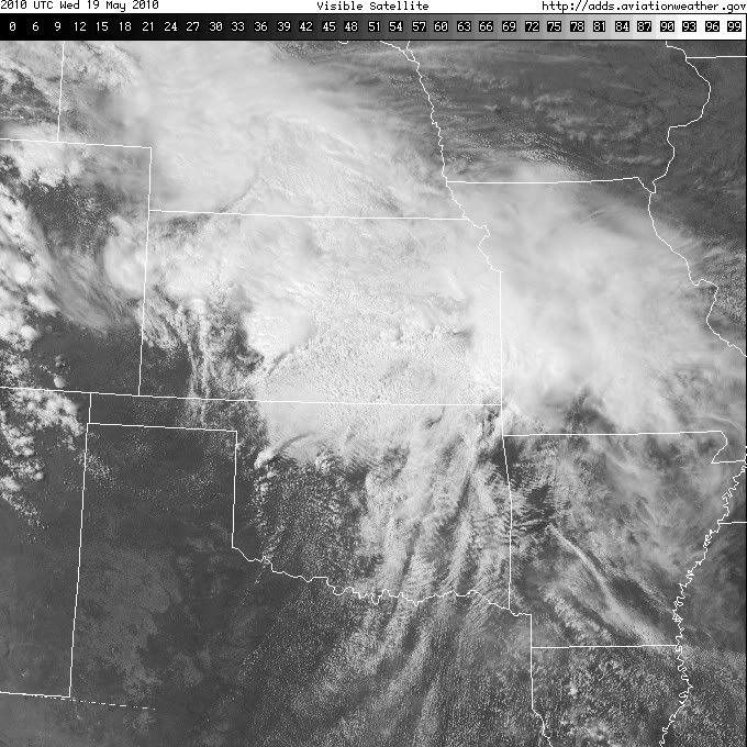
Tornado and Severe Weather Outbreak May 18-20

U.S. & Caribbean Weather Discussions and Severe Weather Events

Moderator: S2k Moderators

Forum rules

The posts in this forum are NOT official forecast and should not be used as such. They are just the opinion of the poster and may or may not be backed by sound meteorological data. They are NOT endorsed by any professional institution or STORM2K.

Help Support Storm2K
Message
Author
snoopj
Category 2
Category 2
Posts: 530
Joined: Wed Sep 10, 2003 9:46 pm
Location: KCMO
Contact:

Re: Re:

#41 Postby snoopj » Wed May 19, 2010 2:41 pm

snoopj wrote:
Dave wrote:Anyone having any problems with GRLevel 3 today? I'm not showing any warnings at all anywhere in the US.


I think that would be due to the fact that there aren't any warnings in the US at this time. Expect that to change soon.

Went to http://warnings.cod.edu/ and the last warning listed there was 9am-ish out of Tulsa.


Just saw a notice on the AllisonHouse support forums. It appears the COD server is down at the moment. Leaky power transformer. Switch the warnings server to the AllisonHouse server and all will be well.
0 likes   

User avatar
Dave
Retired Staff
Retired Staff
Posts: 13442
Age: 74
Joined: Tue Aug 01, 2006 3:57 pm
Location: Milan Indiana
Contact:

Re: Re:

#42 Postby Dave » Wed May 19, 2010 2:43 pm

snoopj wrote:
snoopj wrote:
Dave wrote:Anyone having any problems with GRLevel 3 today? I'm not showing any warnings at all anywhere in the US.


I think that would be due to the fact that there aren't any warnings in the US at this time. Expect that to change soon.

Went to http://warnings.cod.edu/ and the last warning listed there was 9am-ish out of Tulsa.


Just saw a notice on the AllisonHouse support forums. It appears the COD server is down at the moment. Leaky power transformer. Switch the warnings server to the AllisonHouse server and all will be well.


Got it....
0 likes   

User avatar
Dave
Retired Staff
Retired Staff
Posts: 13442
Age: 74
Joined: Tue Aug 01, 2006 3:57 pm
Location: Milan Indiana
Contact:

#43 Postby Dave » Wed May 19, 2010 2:53 pm

If nothing else looks like the chase teams are ready....

Image
0 likes   

User avatar
thetruesms
Professional-Met
Professional-Met
Posts: 844
Age: 41
Joined: Thu Aug 16, 2007 1:14 pm
Location: Tallahasee, FL
Contact:

#44 Postby thetruesms » Wed May 19, 2010 3:00 pm

I'd always thought it would be amusing if SPC would include chaser convergence in their mesoscale analysis :lol:

Most of the names are obviously unreadable, but I can see a couple of friends are making some interesting plays today
0 likes   

snoopj
Category 2
Category 2
Posts: 530
Joined: Wed Sep 10, 2003 9:46 pm
Location: KCMO
Contact:

Re:

#45 Postby snoopj » Wed May 19, 2010 3:02 pm

Dave wrote:If nothing else looks like the chase teams are ready....


That's insane. Let's hope they play it safe and no one gets seriously injured today. I worry with the popularity it's become that someone is going to go for the extreme closeup to impress The Weather Channel and going to pay the ultimate price for it.
0 likes   

CrazyC83
Professional-Met
Professional-Met
Posts: 34001
Joined: Tue Mar 07, 2006 11:57 pm
Location: Deep South, for the first time!

#46 Postby CrazyC83 » Wed May 19, 2010 3:06 pm

2000Z: No significant change.

SPC AC 191958

DAY 1 CONVECTIVE OUTLOOK
NWS STORM PREDICTION CENTER NORMAN OK
0258 PM CDT WED MAY 19 2010

VALID 192000Z - 201200Z

...THERE IS A HIGH RISK OF SVR TSTMS ACROSS CENTRAL OK...

...THERE IS A MDT RISK OF SVR TSTMS SURROUNDING THE HIGH RISK AREA
OVER A LARGE PART OF OK AND NRN TX...

...THERE IS A SLGT RISK OF SVR TSTMS SURROUNDING THE MDT RISK
AREA...FROM SW KS INTO THE LWR MS VLY....

PREVIOUS FORECAST ON TRACK WITH ONLY MINOR ADJUSTMENTS.

CONVECTION HAS RECENTLY DEVELOPED NEAR WARM FRONT/DRYLINE
INTERSECTION IN WRN OK AND MAY ALSO DEVELOP SHORTLY ALONG LOW LEVEL
CONFLUENCE LOCATED EAST OF OKC. AS DRYLINE AND UPPER TROUGH
SHIFT EWD...STORMS SHOULD INCREASE IN COVERAGE AND INTENSITY INTO
THE EVENING HOURS...REFERENCE WW 190. SURFACE OBSERVATIONS SHOW
BOUNDARY LAYER WINDS HAVE VEERED ACROSS SWRN OK AND WEAKENED
SOMEWHAT ALOFT AS VORTEX2 SOUNDING IN WRN OK SHOWED 850 MB WINDS
WERE 210/15KT COMPARED TO 35 KT AT OKC AT THE SAME TIME. REORIENTED
THE HIGH RISK AREA ALONG WARM FRONT...WHERE LOW LEVEL JET/SHEAR WILL
BE MAXIMIZED THROUGH EARLY EVENING. THE HIGH RISK EXTENDS FROM NW OF
OKC ESEWD TO THE MUSKOGEE/MCALESTER AREAS AND HAS THE HIGHEST
POTENTIAL FOR SIGNIFICANT TORNADOES AS WELL AS EXTREME HAIL/DAMAGING
WINDS. MLCAPE VALUES TO 3000 J/KG SOUTH OF WARM FRONT AND STRONGER
LOW LEVEL SHEAR NORTH OF WARM FRONT WILL FAVOR STRONG SUPERCELLS
WITH TORNADOES...LARGE HAIL AND DAMAGING WINDS ESPECIALLY ACROSS THE
MODERATE RISK AREA.

LATER TONIGHT...STORMS ARE EXPECTED TO CONGEAL INTO AND ONE OR MORE
MCS/S. IT APPEARS LIKELY THAT THESE SYSTEMS WILL ADVANCE FURTHER EWD
THAN EARLIER ANTICIPATED...SO THE SLIGHT RISK HAS BEEN EXTENDED
FURTHER EWD INTO PORTIONS OF SRN MO/AR FOR LATE TONIGHT. THE
CONSOLIDATED OUTFLOW AND STRENGTHENING SWLY FLOW ALOFT INDICATES THE
PRIMARY THREAT SHOULD BE DAMAGING WINDS.

..IMY.. 05/19/2010
0 likes   

User avatar
KWT
Category 5
Category 5
Posts: 31415
Joined: Tue Aug 17, 2004 11:02 am
Location: UK!!!

Re: Re:

#47 Postby KWT » Wed May 19, 2010 3:09 pm

snoopj wrote:
Dave wrote:If nothing else looks like the chase teams are ready....


That's insane. Let's hope they play it safe and no one gets seriously injured today. I worry with the popularity it's become that someone is going to go for the extreme closeup to impress The Weather Channel and going to pay the ultimate price for it.


Yep lets hope everyone remains safe, I know the British team I'm following is also in there today, already half way through thier tour, another 20 days to go, and a good 4-5 days have been high risk already as well which is insane
0 likes   
Personal Forecast Disclaimer:
The posts in this forum are NOT official forecast and should not be used as such. They are just the opinion of the poster and may or may not be backed by sound meteorological data. They are NOT endorsed by any professional institution or storm2k.org. For official information, please refer to the NHC and NWS products

User avatar
thetruesms
Professional-Met
Professional-Met
Posts: 844
Age: 41
Joined: Thu Aug 16, 2007 1:14 pm
Location: Tallahasee, FL
Contact:

Re:

#48 Postby thetruesms » Wed May 19, 2010 3:10 pm

CrazyC83 wrote:SURFACE OBSERVATIONS SHOW
BOUNDARY LAYER WINDS HAVE VEERED ACROSS SWRN OK AND WEAKENED
SOMEWHAT ALOFT AS VORTEX2 SOUNDING IN WRN OK SHOWED 850 MB WINDS
WERE 210/15KT COMPARED TO 35 KT AT OKC AT THE SAME TIME.
If only we could have these all over the place, all the time 8-)
0 likes   

User avatar
Texas Snowman
Storm2k Moderator
Storm2k Moderator
Posts: 6151
Joined: Fri Jan 25, 2008 11:29 am
Location: Denison, Texas

Re: Re:

#49 Postby Texas Snowman » Wed May 19, 2010 3:12 pm

snoopj wrote:
Dave wrote:If nothing else looks like the chase teams are ready....


That's insane. Let's hope they play it safe and no one gets seriously injured today. I worry with the popularity it's become that someone is going to go for the extreme closeup to impress The Weather Channel and going to pay the ultimate price for it.


Well, that pretty much happened on the May 10th outbreak didn't it?

Someone was a couple of hundred yards or less from a multi-vortex tornado and videoing it as it was wrapping up and passing over a roadway. They were interviewed on one of the morning news shows.

Fortunately, they got away with it but it was WAY TOO CLOSE FOR COMFORT!!!
0 likes   
The above post and any post by Texas Snowman is NOT an official forecast and should not be used as such. It is just the opinion of the poster and may or may not be backed by sound meteorological data. It is NOT endorsed by any professional institution including storm2k.org. For official information, please refer to NWS products.

User avatar
Dave
Retired Staff
Retired Staff
Posts: 13442
Age: 74
Joined: Tue Aug 01, 2006 3:57 pm
Location: Milan Indiana
Contact:

#50 Postby Dave » Wed May 19, 2010 3:12 pm

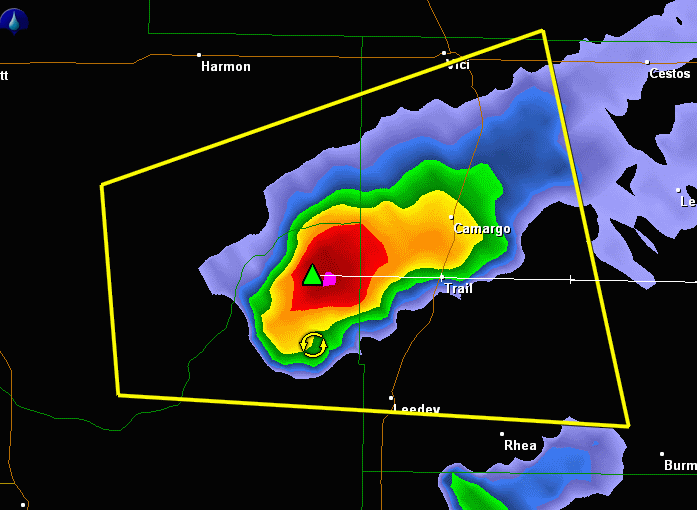
BULLETIN - IMMEDIATE BROADCAST REQUESTED
SEVERE THUNDERSTORM WARNING
NATIONAL WEATHER SERVICE NORMAN OK
312 PM CDT WED MAY 19 2010

THE NATIONAL WEATHER SERVICE IN NORMAN HAS ISSUED A

* SEVERE THUNDERSTORM WARNING FOR...
WESTERN DEWEY COUNTY IN NORTHWEST OKLAHOMA...
SOUTHEASTERN ELLIS COUNTY IN NORTHWEST OKLAHOMA...
NORTHEASTERN ROGER MILLS COUNTY IN WESTERN OKLAHOMA...

* UNTIL 415 PM CDT

* AT 312 PM CDT...NATIONAL WEATHER SERVICE RADAR INDICATED A SEVERE
THUNDERSTORM 9 MILES NORTHWEST OF LEEDEY...MOVING EAST AT 10 MPH.

HAZARDS IN THE WARNING INCLUDE...
HAIL UP TO THE SIZE OF QUARTERS...
WIND GUSTS TO 60 MPH...

* LOCATIONS IN THE WARNING INCLUDE CAMARGO AND LEEDEY.
0 likes   

CrazyC83
Professional-Met
Professional-Met
Posts: 34001
Joined: Tue Mar 07, 2006 11:57 pm
Location: Deep South, for the first time!

Re: Moderate Risk for North Texas 5-19

#51 Postby CrazyC83 » Wed May 19, 2010 3:14 pm

Current conditions in the threat area - 3:00 pm CDT (Red - city in MDT, purple - city in HIGH)

Arkansas
DeQueen - A few clouds, 80 (68)
Fayetteville - Partly cloudy, 69 (58)
Fort Smith - A few clouds, 76 (59)
Mena - Mostly cloudy, 77 (63)
Texarkana - A few clouds, 82 (68)

Kansas
Chaunte - Light rainshower, 57 (55)
Dodge City - Partly cloudy, 61 (56)
Garden City - Light rainshower, 62 (57)
Medicine Lodge - Overcast, 60 (59)
Wichita - Rain, 61 (57)

Oklahoma
Altus - A few clouds, 83 (63)
Ardmore - Mostly cloudy, 81 (66)
Bartlesville - Mostly cloudy, 64 (59)
Clinton - A few clouds, 83 (58)
Enid - Fog, 64 (64)
Lawton - A few clouds, 85 (66)
McAlester - Partly cloudy, 77 (66)
Muskogee - Mostly cloudy, 72 (61)
Oklahoma City - A few clouds, 78 (67)
Stillwater - Mostly cloudy, 67 (61)
Tulsa - Partly cloudy, 68 (60)
Woodward - A few clouds, 73 (62)

Texas
Abilene - Clear, 85 (64)
Dallas - A few clouds, 86 (66)
Fort Worth - Partly cloudy, 86 (68)
Paris - Mostly cloudy, 84 (73)
Sherman - Mostly cloudy, 82 (67)
Tyler - Partly cloudy, 89 (65)
Waco - Partly cloudy, 90 (66)
Wichita Falls - A few clouds, 84 (66)
0 likes   

CrazyC83
Professional-Met
Professional-Met
Posts: 34001
Joined: Tue Mar 07, 2006 11:57 pm
Location: Deep South, for the first time!

Re: Re:

#52 Postby CrazyC83 » Wed May 19, 2010 3:14 pm

Texas Snowman wrote:
snoopj wrote:
Dave wrote:If nothing else looks like the chase teams are ready....


That's insane. Let's hope they play it safe and no one gets seriously injured today. I worry with the popularity it's become that someone is going to go for the extreme closeup to impress The Weather Channel and going to pay the ultimate price for it.


Well, that pretty much happened on the May 10th outbreak didn't it?

Someone was a couple of hundred yards or less from a multi-vortex tornado and videoing it as it was wrapping up and passing over a roadway. They were interviewed on one of the morning news shows.

Fortunately, they got away with it but it was WAY TOO CLOSE FOR COMFORT!!!


Seriously, in these high risk situations, only the most trained professionals should be out there chasing.
0 likes   

CrazyC83
Professional-Met
Professional-Met
Posts: 34001
Joined: Tue Mar 07, 2006 11:57 pm
Location: Deep South, for the first time!

#53 Postby CrazyC83 » Wed May 19, 2010 3:15 pm

The Leedey cell seems to be starting to rotate now.
0 likes   

User avatar
Bunkertor
Category 5
Category 5
Posts: 3397
Joined: Tue May 09, 2006 3:48 pm

Re:

#54 Postby Bunkertor » Wed May 19, 2010 3:17 pm

Dave wrote:If nothing else looks like the chase teams are ready....


Mike Brown is out there, too. He has got plenty time now ... :lol:
0 likes   

User avatar
srainhoutx
S2K Supporter
S2K Supporter
Posts: 6919
Age: 67
Joined: Sun Jan 14, 2007 11:34 am
Location: Haywood County, NC
Contact:

Re: Moderate Risk for North Texas 5-19

#55 Postby srainhoutx » Wed May 19, 2010 3:19 pm

Perhaps Texas Snowman can edit the Topic Title to High Risk and cover OK as well.
0 likes   
Carla/Alicia/Jerry(In The Eye)/Michelle/Charley/Ivan/Dennis/Katrina/Rita/Wilma/Ike/Harvey

Member: National Weather Association
Wx Infinity Forums
http://wxinfinity.com/index.php

Facebook.com/WeatherInfinity
Twitter @WeatherInfinity

User avatar
Dave
Retired Staff
Retired Staff
Posts: 13442
Age: 74
Joined: Tue Aug 01, 2006 3:57 pm
Location: Milan Indiana
Contact:

#56 Postby Dave » Wed May 19, 2010 3:24 pm

Image
0 likes   

User avatar
Dave
Retired Staff
Retired Staff
Posts: 13442
Age: 74
Joined: Tue Aug 01, 2006 3:57 pm
Location: Milan Indiana
Contact:

#57 Postby Dave » Wed May 19, 2010 3:26 pm

Image
0 likes   

User avatar
Texas Snowman
Storm2k Moderator
Storm2k Moderator
Posts: 6151
Joined: Fri Jan 25, 2008 11:29 am
Location: Denison, Texas

Re: Moderate Risk for North Texas 5-19

#58 Postby Texas Snowman » Wed May 19, 2010 3:26 pm

srainhoutx wrote:Perhaps Texas Snowman can edit the Topic Title to High Risk and cover OK as well.


Oooppps! 8-)

Thanks for the reminder Srainhoutx!
0 likes   
The above post and any post by Texas Snowman is NOT an official forecast and should not be used as such. It is just the opinion of the poster and may or may not be backed by sound meteorological data. It is NOT endorsed by any professional institution including storm2k.org. For official information, please refer to NWS products.

CrazyC83
Professional-Met
Professional-Met
Posts: 34001
Joined: Tue Mar 07, 2006 11:57 pm
Location: Deep South, for the first time!

Re: High Risk / PDS Tornado Watch 5-19

#59 Postby CrazyC83 » Wed May 19, 2010 3:26 pm

MESOSCALE DISCUSSION 0624
NWS STORM PREDICTION CENTER NORMAN OK
0320 PM CDT WED MAY 19 2010

AREAS AFFECTED...OK

CONCERNING...TORNADO WATCH 190...

VALID 192020Z - 192145Z

THE SEVERE WEATHER THREAT FOR TORNADO WATCH 190 CONTINUES.

20Z MESOANALYSIS PLACES A LOW JUST S OF KGAG WITH A WRMFNT ESE
ACROSS DEWEY...BLAINE...KINGFISHER...OKLAHOMA COUNTIES...THEN SEWD
TO CHOCTAW COUNTY. A DRYLINE EXTENDED S FROM THE LOW INTO THE ALTUS
AREA.

TSTMS WERE INCREASING OVER WCNTRL OK NEAR THE TRIPLE POINT AND WILL
LIKELY BUILD SWD ALONG THE DRYLINE THROUGH LATE AFTN. OTHER STORMS
WILL CONTINUE TO GROW ALONG THE WRMFNT FROM JUST W OF KOKC WNW INTO
BLAINE/MAJOR COUNTIES. YET A THIRD REGION OF INITIATION...PER
LATEST RAPID REFRESH AND RECENT TCU DEVELOPMENT...WILL BE ACROSS
SERN OK TO THE SW THROUGH NW OF KMLC ALONG A POSSIBLE GRAVITY WAVE.

AS STORMS MATURE INTO SUPERCELLS THEY WILL MOVE 250/30 KTS WITH THE
TORNADO THREAT MAXIMIZED INVOF THE WRMFNT...PARTICULARLY FROM
KINGFISHER ESE THROUGH OKC METRO AND INTO SE OK NEAR KMLC.
THIS
ZONE WILL MAINTAIN ESELY LLVL FLOW VEERING QUICKLY TO SW ABOVE 2-3
KM AMIDST LOW LCLS. VERY LARGE HAIL CAN ALSO BE EXPECTED.

..RACY.. 05/19/2010


ATTN...WFO...SHV...TSA...FWD...OUN...

LAT...LON 36249762 35909482 34089459 33529703 34249867 34939956
35939997 36249762
0 likes   

CrazyC83
Professional-Met
Professional-Met
Posts: 34001
Joined: Tue Mar 07, 2006 11:57 pm
Location: Deep South, for the first time!

Re: High Risk / PDS Tornado Watch 5-19

#60 Postby CrazyC83 » Wed May 19, 2010 3:27 pm

WFUS54 KOUN 192026
TOROUN
OKC011-073-192100-
/O.NEW.KOUN.TO.W.0049.100519T2026Z-100519T2100Z/

BULLETIN - EAS ACTIVATION REQUESTED
TORNADO WARNING
NATIONAL WEATHER SERVICE NORMAN OK
326 PM CDT WED MAY 19 2010

THE NATIONAL WEATHER SERVICE IN NORMAN HAS ISSUED A

* TORNADO WARNING FOR...
NORTHWESTERN KINGFISHER COUNTY IN CENTRAL OKLAHOMA...
NORTHEASTERN BLAINE COUNTY IN NORTHWEST OKLAHOMA...

* UNTIL 400 PM CDT

* AT 326 PM CDT...STORM SPOTTERS REPORTED A TORNADO 5 MILES SOUTH OF
OKEENE
...MOVING NORTHEAST AT 20 MPH.

* LOCATIONS IN THE WARNING INCLUDE LACEY.

PRECAUTIONARY/PREPAREDNESS ACTIONS...

TAKE COVER NOW. LEAVE MOBILE HOMES AND VEHICLES. IF POSSIBLE...MOVE
TO A BASEMENT OR STORM SHELTER. OTHERWISE MOVE TO AN INTERIOR ROOM OR
HALLWAY ON THE LOWEST FLOOR. STAY AWAY FROM WINDOWS AND OUTSIDE
WALLS.

&&

LAT...LON 3617 9826 3616 9801 3596 9822 3600 9840
TIME...MOT...LOC 2026Z 212DEG 16KT 3605 9828

$$


30
0 likes   


Return to “USA & Caribbean Weather”

Who is online

Users browsing this forum: South Texas Storms and 33 guests