I'd say Norman gets an A+ on defining the high risk area...they bulls-eyed the tornadic action this afternoon and evening in Oklahoma.
To the south however, the moderate risk area in North Texas hardly had a raindrop...
Tornado and Severe Weather Outbreak May 18-20
Moderator: S2k Moderators
Forum rules

The posts in this forum are NOT official forecast and should not be used as such. They are just the opinion of the poster and may or may not be backed by sound meteorological data. They are NOT endorsed by any professional institution or STORM2K.
-
Texas Snowman

- Storm2k Moderator

- Posts: 6197
- Joined: Fri Jan 25, 2008 11:29 am
- Location: Denison, Texas
Re: High Risk / PDS Tornado Watch 5-19
0 likes
The above post and any post by Texas Snowman is NOT an official forecast and should not be used as such. It is just the opinion of the poster and may or may not be backed by sound meteorological data. It is NOT endorsed by any professional institution including storm2k.org. For official information, please refer to NWS products.
-
cheezyWXguy

- Category 5

- Posts: 6282
- Joined: Mon Feb 13, 2006 12:29 am
- Location: Dallas, TX
Re: High Risk / PDS Tornado Watch 5-19
Texas Snowman wrote:I'd say Norman gets an A+ on defining the high risk area...they bulls-eyed the tornadic action this afternoon and evening in Oklahoma.
To the south however, the moderate risk area in North Texas hardly had a raindrop...
apparently theyre still expecting the front to convect after midnight when it crosses the red river, but even if that happens, DFW nws seems to have dropped the ball on this one.
0 likes
-
somethingfunny

- ChatStaff

- Posts: 3926
- Age: 37
- Joined: Thu May 31, 2007 10:30 pm
- Location: McKinney, Texas
Re: High Risk / PDS Tornado Watch 5-19
Texas Snowman wrote:I'd say Norman gets an A+ on defining the high risk area...they bulls-eyed the tornadic action this afternoon and evening in Oklahoma.
To the south however, the moderate risk area in North Texas hardly had a raindrop...
Definitely A+ for Norman. No rain in North Texas...yet. That AFD Discussion was one of the more interesting ones that I've read....they basically said "God reminded us who's in charge", yet the models are still showing a squall line developing after midnight. I'm not sure I've ever seen nocturnal initiation of storms.....but I wouldn't go ahead and crack my car's windows in the driveway just yet.
0 likes
-
Dave

- Retired Staff

- Posts: 13442
- Age: 75
- Joined: Tue Aug 01, 2006 3:57 pm
- Location: Milan Indiana
- Contact:
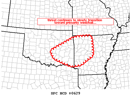
MESOSCALE DISCUSSION 0629
NWS STORM PREDICTION CENTER NORMAN OK
1109 PM CDT WED MAY 19 2010
AREAS AFFECTED...ERN OK/WRN AR
CONCERNING...TORNADO WATCH 191...192...
VALID 200409Z - 200545Z
THE SEVERE WEATHER THREAT FOR TORNADO WATCH 191...192...CONTINUES.
WIDESPREAD AREA OF STRONG/SEVERE STORMS CONTINUES ACROSS ERN OK/WRN
AR.
LATEST RADAR LOOP SHOWS SEVERAL SEVERE STORMS/STORM CLUSTERS MOVING
ACROSS ERN OK ATTM...WHILE COVERAGE OF STORMS CONTINUES TO INCREASE
ACROSS WRN AR. STORMS MOVING ACROSS OK CONTINUE TO SLOWLY EVOLVE
INTO AN MCS...AND THUS MAIN THREAT IN THIS AREA CONTINUES TO
TRANSITION TOWARD LARGE HAIL AND DAMAGING WINDS.
MEANWHILE...MORE ISOLATED STORMS DEVELOPING ACROSS AR ARE ALSO
EXPECTED TO BECOME CONGEALED/LESS ISOLATED OVER THE NEXT COUPLE OF
HOURS...WITH HAIL/WIND THREAT BECOMING PREDOMINANT. IN THE MEAN
TIME HOWEVER...A FEW ISOLATED ROTATING CELLS WITHIN THE LARGER
CONVECTIVE AREA WILL CONTINUE TO POSE A TORNADO THREAT.
..GOSS.. 05/20/2010
ATTN...WFO...LZK...SHV...TSA...OUN...
LAT...LON 34479658 35129700 36369440 36459253 34759244 33959372
33809476 34479658
0 likes
-
cheezyWXguy
- Category 5
- Posts: 6282
- Joined: Mon Feb 13, 2006 12:29 am
- Location: Dallas, TX
Re: High Risk / PDS Tornado Watch 5-19
somethingfunny wrote:Texas Snowman wrote:I'd say Norman gets an A+ on defining the high risk area...they bulls-eyed the tornadic action this afternoon and evening in Oklahoma.
To the south however, the moderate risk area in North Texas hardly had a raindrop...
Definitely A+ for Norman. No rain in North Texas...yet. That AFD Discussion was one of the more interesting ones that I've read....they basically said "God reminded us who's in charge", yet the models are still showing a squall line developing after midnight. I'm not sure I've ever seen nocturnal initiation of storms.....but I wouldn't go ahead and crack my car's windows in the driveway just yet.
happens from time to time, in fact it looks like it maybe starting in southern ok, with a lone cell out there
0 likes
-
Texas Snowman
- Storm2k Moderator
- Posts: 6197
- Joined: Fri Jan 25, 2008 11:29 am
- Location: Denison, Texas
Re: High Risk / PDS Tornado Watch 5-19
Heard this morning on radio news that NWS says there were at least 16 tornado touchdowns in Oklahoma yesterday.
No serious injuries have been reported though.
No serious injuries have been reported though.
0 likes
The above post and any post by Texas Snowman is NOT an official forecast and should not be used as such. It is just the opinion of the poster and may or may not be backed by sound meteorological data. It is NOT endorsed by any professional institution including storm2k.org. For official information, please refer to NWS products.
-
somethingfunny
- ChatStaff
- Posts: 3926
- Age: 37
- Joined: Thu May 31, 2007 10:30 pm
- Location: McKinney, Texas
Re: High Risk / PDS Tornado Watch 5-19
Hey! The cold front is popping again!!!! 
*goes outside to dance in the rain* - this part of DFW has been getting shafted by the past few systems.
*goes outside to dance in the rain* - this part of DFW has been getting shafted by the past few systems.
0 likes
-
Texas Snowman
- Storm2k Moderator
- Posts: 6197
- Joined: Fri Jan 25, 2008 11:29 am
- Location: Denison, Texas
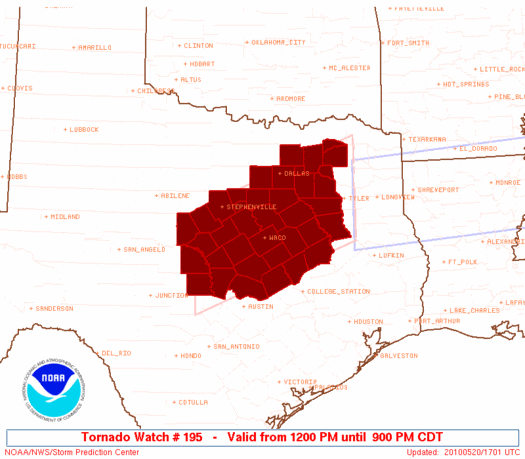
New tornado watch 195 coming out...
TORNADO WATCH OUTLINE UPDATE FOR WT 195
NWS STORM PREDICTION CENTER NORMAN OK
1200 PM CDT THU MAY 20 2010
TORNADO WATCH 195 IS IN EFFECT UNTIL 900 PM CDT FOR THE
FOLLOWING LOCATIONS
TXC001-027-035-049-053-085-093-099-113-119-139-143-145-161-193-
213-217-221-223-231-251-257-281-289-293-299-309-331-333-349-379-
395-397-411-425-439-467-491-210200-
/O.NEW.KWNS.TO.A.0195.100520T1700Z-100521T0200Z/
TX
. TEXAS COUNTIES INCLUDED ARE
ANDERSON BELL BOSQUE
BROWN BURNET COLLIN
COMANCHE CORYELL DALLAS
DELTA ELLIS ERATH
FALLS FREESTONE HAMILTON
HENDERSON HILL HOOD
HOPKINS HUNT JOHNSON
KAUFMAN LAMPASAS LEON
LIMESTONE LLANO MCLENNAN
MILAM MILLS NAVARRO
RAINS ROBERTSON ROCKWALL
SAN SABA SOMERVELL TARRANT
VAN ZANDT WILLIAMSON
$$
ATTN...WFO...FWD...EWX...SJT...
0 likes
The above post and any post by Texas Snowman is NOT an official forecast and should not be used as such. It is just the opinion of the poster and may or may not be backed by sound meteorological data. It is NOT endorsed by any professional institution including storm2k.org. For official information, please refer to NWS products.
-
srainhoutx

- S2K Supporter

- Posts: 6919
- Age: 68
- Joined: Sun Jan 14, 2007 11:34 am
- Location: Haywood County, NC
- Contact:
Re: Tornado and Severe Weather Outbreak May 19-20
0 likes
Carla/Alicia/Jerry(In The Eye)/Michelle/Charley/Ivan/Dennis/Katrina/Rita/Wilma/Ike/Harvey
Member: National Weather Association
Wx Infinity Forums
http://wxinfinity.com/index.php
Facebook.com/WeatherInfinity
Twitter @WeatherInfinity
Member: National Weather Association
Wx Infinity Forums
http://wxinfinity.com/index.php
Facebook.com/WeatherInfinity
Twitter @WeatherInfinity


-
somethingfunny
- ChatStaff
- Posts: 3926
- Age: 37
- Joined: Thu May 31, 2007 10:30 pm
- Location: McKinney, Texas
Re: Tornado and Severe Weather Outbreak May 19-20
I'm in the hole AGAIN  .... there's storms aligned east-west roughly along George Bush Turnpike about 7 miles north of me....and storms aligned roughly east-west along I-30 in Dallas about 7 miles south of me....Garland threads the gap once again!
I'm still hoping to squeeze a few drops out of this storm. If I decide to walk to the store, that might coax a few more clouds my way.
I'm still hoping to squeeze a few drops out of this storm. If I decide to walk to the store, that might coax a few more clouds my way.
0 likes
Re: Tornado and Severe Weather Outbreak May 19-20
Ntxwx wrote:But rapidly weaking^
^ Where can i see that ?
0 likes
Re: Tornado and Severe Weather Outbreak May 19-20
Bunkertor wrote:Ntxwx wrote:But rapidly weaking^
^ Where can i see that ?
Do observations... But if you can't then here is this from the FWD NWS
LATE MORNING CONVECTION HAS TAKING OFF ALONG THE COLD FRONT FROM
GRANBURY NORTHEASTWARD. THE MORNING OUTFLOW BOUNDARY WAS
POSITIONED NEAR THE SABINE RIVER FROM NORTH OF MCKINNEY TO NORTH
OF LONGVIEW. LOCAL ATMOSPHERE ALONG AND SOUTHEAST OF THE COLD
FRONT REMAINS VERY UNSTABLE WITH MLCAPE TO 3000 J/KG...PWATS OF
1.40 INCHES AND A WEAKENING CAP .
0 likes
Re: Tornado and Severe Weather Outbreak May 19-20
You're welcome...
The cold front is stalling and creating a boundary as mositure feeds in from the southeast the Tornado Watch is well placed. Daytime heating should help to elevate these storms within the next couple of hours. It isn't quite over yet for Dallas/Fort Worth. Keep a close eye on the cold front as it should be the focus point for storms to fire up shortly.
The cold front is stalling and creating a boundary as mositure feeds in from the southeast the Tornado Watch is well placed. Daytime heating should help to elevate these storms within the next couple of hours. It isn't quite over yet for Dallas/Fort Worth. Keep a close eye on the cold front as it should be the focus point for storms to fire up shortly.
0 likes
-
Dave
- Retired Staff
- Posts: 13442
- Age: 75
- Joined: Tue Aug 01, 2006 3:57 pm
- Location: Milan Indiana
- Contact:
Additional Watch Information:
TORNADO WATCH NUMBER 195
NWS STORM PREDICTION CENTER NORMAN OK
1200 PM CDT THU MAY 20 2010
THE NWS STORM PREDICTION CENTER HAS ISSUED A
TORNADO WATCH FOR PORTIONS OF
CENTRAL AND NORTH TEXAS
EFFECTIVE THIS THURSDAY AFTERNOON AND EVENING FROM NOON UNTIL 900
PM CDT.
TORNADOES...HAIL TO 4 INCHES IN DIAMETER...THUNDERSTORM WIND
GUSTS TO 70 MPH...AND DANGEROUS LIGHTNING ARE POSSIBLE IN THESE
AREAS.
THE TORNADO WATCH AREA IS APPROXIMATELY ALONG AND 70 STATUTE
MILES NORTH AND SOUTH OF A LINE FROM 20 MILES NORTHEAST OF TYLER
TEXAS TO 80 MILES WEST OF TEMPLE TEXAS. FOR A COMPLETE DEPICTION
OF THE WATCH SEE THE ASSOCIATED WATCH OUTLINE UPDATE (WOUS64 KWNS
WOU5).
REMEMBER...A TORNADO WATCH MEANS CONDITIONS ARE FAVORABLE FOR
TORNADOES AND SEVERE THUNDERSTORMS IN AND CLOSE TO THE WATCH
AREA. PERSONS IN THESE AREAS SHOULD BE ON THE LOOKOUT FOR
THREATENING WEATHER CONDITIONS AND LISTEN FOR LATER STATEMENTS
AND POSSIBLE WARNINGS.
OTHER WATCH INFORMATION...CONTINUE...WW 194...
DISCUSSION...TSTMS NOW NEAR COLD FRONT/OUTFLOW BOUNDARY INTERSECTION
IN NE TX EXPECTED TO DEVELOP SW ALONG COLD FRONT LATER TODAY AS SFC
HEATING FURTHER DESTABILIZES REGION REF MCD 633/. LOW LVL FLOW WILL
REMAIN MODEST...WITH 850 MB SSW WINDS LIKELY TO REMAIN AROUND 20
KTS. BUT WIND PROFILES WILL MAINTAIN DEEP-LAYER VEERING...WITH 250
MB WNW FLOW AROUND 70 KTS. COUPLED WITH RICH LOW LVL MOISTURE AND
VERY STEEP LOW TO MID LVL LAPSE RATES...SETUP MAY SUPPORT A FEW
STRONG SUPERCELLS. AS COLD FRONT IS QUITE SHALLOW AND SLOWLY
MOVING...THESE MAY REMAIN DISCRETE AND POSE A THREAT FOR
TORNADOES...IN ADDITION TO VERY LARGE HAIL AND LOCALLY DMGG WIND.
AVIATION...TORNADOES AND A FEW SEVERE THUNDERSTORMS WITH HAIL
SURFACE AND ALOFT TO 4 INCHES. EXTREME TURBULENCE AND SURFACE
WIND GUSTS TO 60 KNOTS. A FEW CUMULONIMBI WITH MAXIMUM TOPS TO
550. MEAN STORM MOTION VECTOR 28025.
0 likes
-
thetruesms

- Professional-Met

- Posts: 844
- Age: 42
- Joined: Thu Aug 16, 2007 1:14 pm
- Location: Tallahasee, FL
- Contact:

Return to “USA & Caribbean Weather”
Who is online
Users browsing this forum: Cpv17, txtwister78 and 150 guests