
ENSO Updates (2007 thru 2023)
Moderator: S2k Moderators
Forum rules

The posts in this forum are NOT official forecasts and should not be used as such. They are just the opinion of the poster and may or may not be backed by sound meteorological data. They are NOT endorsed by any professional institution or STORM2K. For official information, please refer to products from the National Hurricane Center and National Weather Service.
-
cycloneye

- Admin

- Posts: 149508
- Age: 69
- Joined: Thu Oct 10, 2002 10:54 am
- Location: San Juan, Puerto Rico
Re: ENSO Updates
The cold waters continue to expand and now it extends over 2,500 miles along the equatorial zone. It looks like La Nina doesn't want to waste time arriving.
0 likes
Visit the Caribbean-Central America Weather Thread where you can find at first post web cams,radars
and observations from Caribbean basin members Click Here
and observations from Caribbean basin members Click Here

Nope, fair play to the models they really have nailed it, you'd be silly to think La Nina isn't developing...
Now we hope it goes mod-strong rapidly, because if it does it could actually help to reverse the trend of a favourable Atlantic, mod/strong La Nina seasons tend to be above average....but not hyperactive....
Now we hope it goes mod-strong rapidly, because if it does it could actually help to reverse the trend of a favourable Atlantic, mod/strong La Nina seasons tend to be above average....but not hyperactive....
0 likes
Personal Forecast Disclaimer:
The posts in this forum are NOT official forecast and should not be used as such. They are just the opinion of the poster and may or may not be backed by sound meteorological data. They are NOT endorsed by any professional institution or storm2k.org. For official information, please refer to the NHC and NWS products
The posts in this forum are NOT official forecast and should not be used as such. They are just the opinion of the poster and may or may not be backed by sound meteorological data. They are NOT endorsed by any professional institution or storm2k.org. For official information, please refer to the NHC and NWS products
-
cycloneye
- Admin
- Posts: 149508
- Age: 69
- Joined: Thu Oct 10, 2002 10:54 am
- Location: San Juan, Puerto Rico
Re: ENSO Updates=CPC 5/17/10: El Nino 3.4 down to -0.1
Climate Prediction Center 5/17/10 update
No surprise the big dip to cold neutral numbers at El Nino 3.4.
Last Week Numbers
Niño 4= +0.5
Niño 3.4= +0.3
Niño 3= +0.5
Niño1+2= +0.2
This Week Numbers
Niño 4= +0.4ºC
Niño 3.4= -0.1ºC
Niño 3= 0.0ºC
Niño1+2= +0.4ºC
http://www.cpc.ncep.noaa.gov/products/a ... ts-web.pdf

No surprise the big dip to cold neutral numbers at El Nino 3.4.
Last Week Numbers
Niño 4= +0.5
Niño 3.4= +0.3
Niño 3= +0.5
Niño1+2= +0.2
This Week Numbers
Niño 4= +0.4ºC
Niño 3.4= -0.1ºC
Niño 3= 0.0ºC
Niño1+2= +0.4ºC
http://www.cpc.ncep.noaa.gov/products/a ... ts-web.pdf
0 likes
Visit the Caribbean-Central America Weather Thread where you can find at first post web cams,radars
and observations from Caribbean basin members Click Here
and observations from Caribbean basin members Click Here
-
StormClouds63
- Category 2

- Posts: 583
- Age: 62
- Joined: Tue May 13, 2008 11:56 am
- Location: Southwest Louisiana
Re: ENSO Updates=CPC 5/17/10: El Nino 3.4 down to -0.1
KWT wrote:Now we hope it goes mod-strong rapidly, because if it does it could actually help to reverse the trend of a favourable Atlantic, mod/strong La Nina seasons tend to be above average....but not hyperactive....
Good point.
0 likes
-
cycloneye
- Admin
- Posts: 149508
- Age: 69
- Joined: Thu Oct 10, 2002 10:54 am
- Location: San Juan, Puerto Rico
Re: ENSO Updates=CPC 5/17/10: El Nino 3.4 down to -0.1
StormClouds63 wrote:KWT wrote:Now we hope it goes mod-strong rapidly, because if it does it could actually help to reverse the trend of a favourable Atlantic, mod/strong La Nina seasons tend to be above average....but not hyperactive....
Good point.
And a moderate to strong La Nina trend to focus the tracks to the south.
0 likes
Visit the Caribbean-Central America Weather Thread where you can find at first post web cams,radars
and observations from Caribbean basin members Click Here
and observations from Caribbean basin members Click Here
They do but I'd be worried that if we get a -ve NAO this summer that would mean a higher risk for landfalls throughout the Caribbean/US...
0 likes
Personal Forecast Disclaimer:
The posts in this forum are NOT official forecast and should not be used as such. They are just the opinion of the poster and may or may not be backed by sound meteorological data. They are NOT endorsed by any professional institution or storm2k.org. For official information, please refer to the NHC and NWS products
The posts in this forum are NOT official forecast and should not be used as such. They are just the opinion of the poster and may or may not be backed by sound meteorological data. They are NOT endorsed by any professional institution or storm2k.org. For official information, please refer to the NHC and NWS products
-
cycloneye
- Admin
- Posts: 149508
- Age: 69
- Joined: Thu Oct 10, 2002 10:54 am
- Location: San Juan, Puerto Rico
Re: ENSO Updates=CPC 5/17/10: El Nino 3.4 down to -0.1
The Australians are at 0.0.

0 likes
Visit the Caribbean-Central America Weather Thread where you can find at first post web cams,radars
and observations from Caribbean basin members Click Here
and observations from Caribbean basin members Click Here
-
brunota2003

- S2K Supporter

- Posts: 9476
- Age: 35
- Joined: Sat Jul 30, 2005 9:56 pm
- Location: Stanton, KY...formerly Havelock, NC
- Contact:
-
cycloneye
- Admin
- Posts: 149508
- Age: 69
- Joined: Thu Oct 10, 2002 10:54 am
- Location: San Juan, Puerto Rico
Re: ENSO Updates
If that very cold pool of water goes to the surface,it may turn to a strong La Nina,but lets see what happens in the next couple of weeks.It appears Climate Prediction Center will proclaim ENSO as Neutral in their June 3rd monthly bulletin,actually playing catchup to the Australians that did that last week.
0 likes
Visit the Caribbean-Central America Weather Thread where you can find at first post web cams,radars
and observations from Caribbean basin members Click Here
and observations from Caribbean basin members Click Here
-
cycloneye
- Admin
- Posts: 149508
- Age: 69
- Joined: Thu Oct 10, 2002 10:54 am
- Location: San Juan, Puerto Rico
Re: ENSO Updates
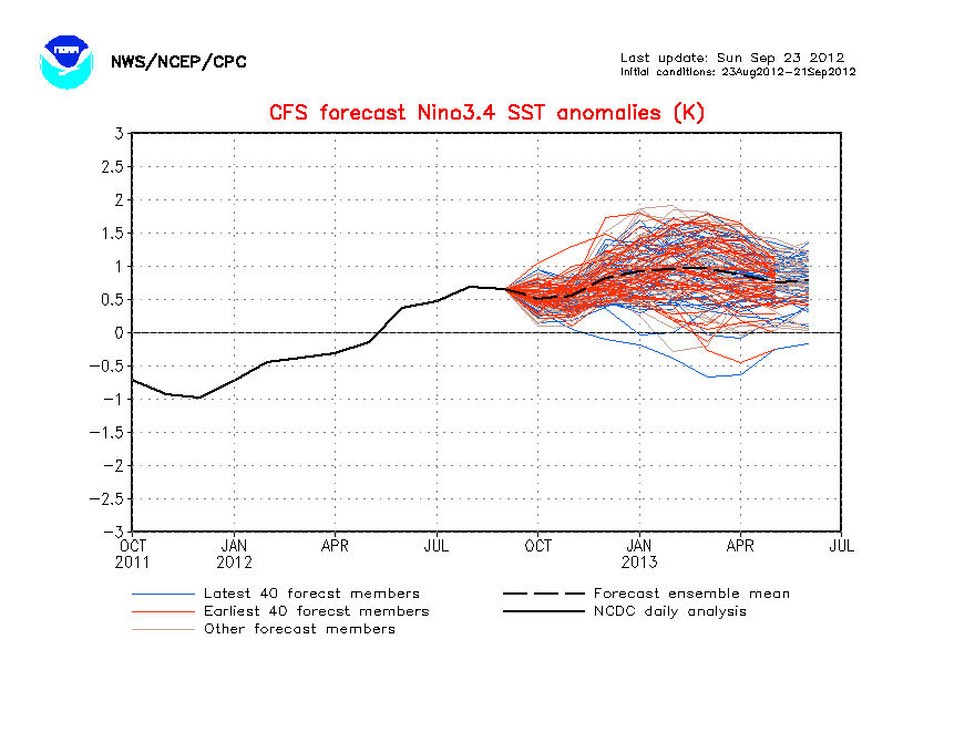
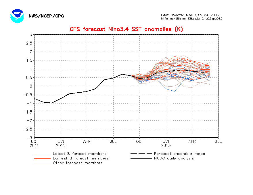
CFS model is taking a nose dive forecasting La Nina as early as mid-June. Also it stays in La Nina thru January.I think ahead,will the 2011 season be in La Nina?
0 likes
Visit the Caribbean-Central America Weather Thread where you can find at first post web cams,radars
and observations from Caribbean basin members Click Here
and observations from Caribbean basin members Click Here
-
cycloneye
- Admin
- Posts: 149508
- Age: 69
- Joined: Thu Oct 10, 2002 10:54 am
- Location: San Juan, Puerto Rico
Re: ENSO Updates
La Nina doesnt want to waste time appearing on the scene.

0 likes
Visit the Caribbean-Central America Weather Thread where you can find at first post web cams,radars
and observations from Caribbean basin members Click Here
and observations from Caribbean basin members Click Here
Models seem to be suggesting an evolution akin to 1998, so that year is clearly one to follow with regards to what will happen this hurricane season, though I'd be doubtful it takes till late July for things to get going given the ENSO is already flipping to La Nina.
0 likes
Personal Forecast Disclaimer:
The posts in this forum are NOT official forecast and should not be used as such. They are just the opinion of the poster and may or may not be backed by sound meteorological data. They are NOT endorsed by any professional institution or storm2k.org. For official information, please refer to the NHC and NWS products
The posts in this forum are NOT official forecast and should not be used as such. They are just the opinion of the poster and may or may not be backed by sound meteorological data. They are NOT endorsed by any professional institution or storm2k.org. For official information, please refer to the NHC and NWS products
-
cycloneye
- Admin
- Posts: 149508
- Age: 69
- Joined: Thu Oct 10, 2002 10:54 am
- Location: San Juan, Puerto Rico
Re: ENSO Updates
The IRI May updated model plume shows the dynamic models between Neutral and La Nina.
http://iri.columbia.edu/climate/ENSO/cu ... pdate.html

Probabilities of El Nino.Neutral and La Nina.
http://iri.columbia.edu/climate/ENSO/cu ... gure3.html

http://iri.columbia.edu/climate/ENSO/cu ... pdate.html
Probabilities of El Nino.Neutral and La Nina.
http://iri.columbia.edu/climate/ENSO/cu ... gure3.html
0 likes
Visit the Caribbean-Central America Weather Thread where you can find at first post web cams,radars
and observations from Caribbean basin members Click Here
and observations from Caribbean basin members Click Here
-
Annie Oakley

- Category 5

- Posts: 1103
- Joined: Tue Jul 31, 2007 12:54 pm
- Location: Texas
-
cycloneye
- Admin
- Posts: 149508
- Age: 69
- Joined: Thu Oct 10, 2002 10:54 am
- Location: San Juan, Puerto Rico
Re: ENSO Updates
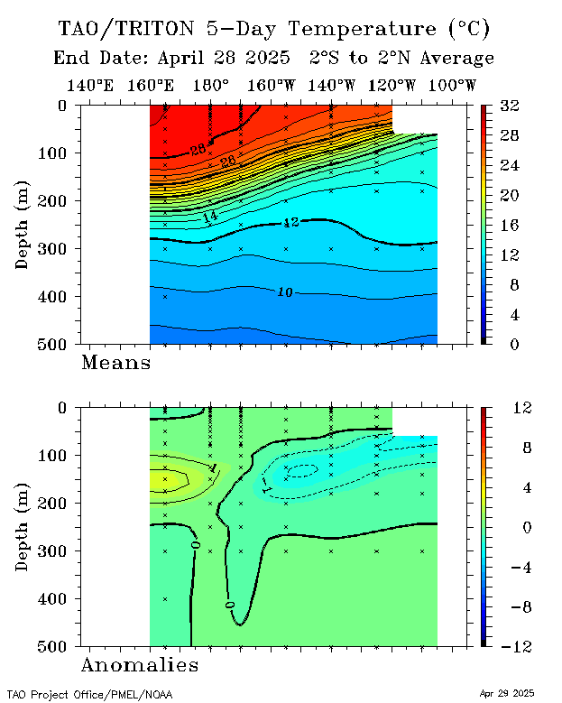
You can see how those cold waters have been propagating eastward and towards the surface in a fast pace in the past two months.At this pace Neutral will not last long.

0 likes
Visit the Caribbean-Central America Weather Thread where you can find at first post web cams,radars
and observations from Caribbean basin members Click Here
and observations from Caribbean basin members Click Here
Will probably see us reach La Nina by June at this rate, the models certainly have done well with this event thus far and the evolution of the pattern.
0 likes
Personal Forecast Disclaimer:
The posts in this forum are NOT official forecast and should not be used as such. They are just the opinion of the poster and may or may not be backed by sound meteorological data. They are NOT endorsed by any professional institution or storm2k.org. For official information, please refer to the NHC and NWS products
The posts in this forum are NOT official forecast and should not be used as such. They are just the opinion of the poster and may or may not be backed by sound meteorological data. They are NOT endorsed by any professional institution or storm2k.org. For official information, please refer to the NHC and NWS products
-
cycloneye
- Admin
- Posts: 149508
- Age: 69
- Joined: Thu Oct 10, 2002 10:54 am
- Location: San Juan, Puerto Rico
Re: ENSO Updates
The only question that has to be asked at this point is not when La Nina will arrive because that is a given but how strong it will be. The CFS model forecasts Weak to Moderate La Nina.
0 likes
Visit the Caribbean-Central America Weather Thread where you can find at first post web cams,radars
and observations from Caribbean basin members Click Here
and observations from Caribbean basin members Click Here


-
cycloneye
- Admin
- Posts: 149508
- Age: 69
- Joined: Thu Oct 10, 2002 10:54 am
- Location: San Juan, Puerto Rico
Re: ENSO Updates
The SOI is in an up and down period but doing it in positive so no signs of El Nino comming back.
Daily SOI values
http://www.longpaddock.qld.gov.au/Seaso ... SOIValues/
Daily 30 day text
http://www.bom.gov.au/climate/enso/soi.txt

Daily SOI values
http://www.longpaddock.qld.gov.au/Seaso ... SOIValues/
Daily 30 day text
http://www.bom.gov.au/climate/enso/soi.txt
0 likes
Visit the Caribbean-Central America Weather Thread where you can find at first post web cams,radars
and observations from Caribbean basin members Click Here
and observations from Caribbean basin members Click Here
-
cycloneye
- Admin
- Posts: 149508
- Age: 69
- Joined: Thu Oct 10, 2002 10:54 am
- Location: San Juan, Puerto Rico
Re: ENSO Updates

0 likes
Visit the Caribbean-Central America Weather Thread where you can find at first post web cams,radars
and observations from Caribbean basin members Click Here
and observations from Caribbean basin members Click Here
Who is online
Users browsing this forum: Ulf and 226 guests