ATL : INVEST 90L
Moderator: S2k Moderators
- Category 5
- Category 5

- Posts: 10074
- Age: 36
- Joined: Sun Feb 11, 2007 10:00 pm
- Location: New Brunswick, NJ
- Contact:
Re: ATL : INVEST 90L
And like pretty much every May Invest 90L, it looks like absolute crap. Should get torn apart by dry air and shear before the umbilical cord is cut.
Honestly I don't know why they bothered with it.
Honestly I don't know why they bothered with it.
0 likes
- HURAKAN
- Professional-Met

- Posts: 46084
- Age: 39
- Joined: Thu May 20, 2004 4:34 pm
- Location: Key West, FL
- Contact:
Re: ATL : INVEST 90L
Category 5 wrote:And like pretty much every May Invest 90L, it looks like absolute crap. Should get torn apart by dry air and shear before the umbilical cord is cut.
Honestly I don't know why they bothered with it.
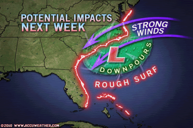
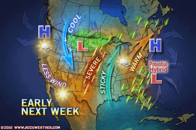
Not every disturbance looks great at the beginning, especially in May, but computer models have been consistent that an organized storm, maybe subtropical or tropical, will be moving towards the east coast early next week. I think it's something we need to watch. At least we're not like the WPAC that tags almost every cloud as an invest!!
0 likes
- Category 5
- Category 5

- Posts: 10074
- Age: 36
- Joined: Sun Feb 11, 2007 10:00 pm
- Location: New Brunswick, NJ
- Contact:
Re: ATL : INVEST 90L
HURAKAN wrote:Category 5 wrote:And like pretty much every May Invest 90L, it looks like absolute crap. Should get torn apart by dry air and shear before the umbilical cord is cut.
Honestly I don't know why they bothered with it.
Not every disturbance looks great at the beginning, especially in May, but computer models have been consistent that an organized storm, maybe subtropical or tropical, will be moving towards the east coast early next week. I think it's something we need to watch. At least we're not like the WPAC that tags almost every cloud as an invest!!
Well when you have 25 per year you have good odds.
Models are one thing, but its in an impossible environment for a system this disorganized, thats my point.
0 likes
- Category 5
- Category 5

- Posts: 10074
- Age: 36
- Joined: Sun Feb 11, 2007 10:00 pm
- Location: New Brunswick, NJ
- Contact:
- cycloneye
- Admin

- Posts: 149585
- Age: 69
- Joined: Thu Oct 10, 2002 10:54 am
- Location: San Juan, Puerto Rico
Re: ATL : INVEST 90L
IMO,I think they designated this as invest a bit premature.I would have waited at least to Saturday or the latest on Sunday but again is my opinion.
0 likes
Visit the Caribbean-Central America Weather Thread where you can find at first post web cams,radars
and observations from Caribbean basin members Click Here
and observations from Caribbean basin members Click Here
- HURAKAN
- Professional-Met

- Posts: 46084
- Age: 39
- Joined: Thu May 20, 2004 4:34 pm
- Location: Key West, FL
- Contact:
Re: ATL : INVEST 90L
cycloneye wrote:IMO,I think they designated this as invest a bit premature.I would have waited at least to Saturday or the latest on Sunday but again is my opinion.
I agree. Sometimes we criticize them bc we feel they're late on tagging a disturbance as invest. lol
Maybe by tomorrow or Sunday, a RECON mission is scheduled for Monday or Tuesday. Fun days ahead!
0 likes
- cycloneye
- Admin

- Posts: 149585
- Age: 69
- Joined: Thu Oct 10, 2002 10:54 am
- Location: San Juan, Puerto Rico
Re: ATL : INVEST 90L
Best Track 18:00z Update
ftp://ftp.tpc.ncep.noaa.gov/atcf/tcweb/
AL, 90, 2010052118, , BEST, 0, 251N, 729W, 25, 1012, LO, 34,
ftp://ftp.tpc.ncep.noaa.gov/atcf/tcweb/
AL, 90, 2010052118, , BEST, 0, 251N, 729W, 25, 1012, LO, 34,
0 likes
Visit the Caribbean-Central America Weather Thread where you can find at first post web cams,radars
and observations from Caribbean basin members Click Here
and observations from Caribbean basin members Click Here
- AJC3
- Admin

- Posts: 4156
- Age: 62
- Joined: Tue Aug 31, 2004 7:04 pm
- Location: Ballston Spa, New York
- Contact:
Re: ATL : INVEST 90L
You might be a tropical weenie if...
"You debate the merits of an invest"
Seriously, you can't really argue that it's too early for the system to be designated an invest because all it really infers at the NHC is interested in the area.
Invest: A weather system for which a tropical cyclone forecast center (NHC, CPHC, or JTWC) is interested in collecting specialized data sets (e.g., microwave imagery) and/or running model guidance. Once a system has been designated as an invest, data collection and processing is initiated on a number of government and academic web sites, including the Naval Research Laboratory (NRL) and the University of Wisconsin Cooperative Institute for Meteorological Satellite Studies (UW-CIMSS). The designation of a system as an invest does not correspond to any particular likelihood of development of the system into a tropical cyclone; operational products such as the Tropical Weather Outlook or the JTWC/TCFA should be consulted for this purpose.
0 likes
- HURAKAN
- Professional-Met

- Posts: 46084
- Age: 39
- Joined: Thu May 20, 2004 4:34 pm
- Location: Key West, FL
- Contact:
Re: ATL : INVEST 90L
AJC3 wrote:You might be a tropical weenie if...
"You debate the merits of an invest"
Guilty!!!
0 likes
- HURAKAN
- Professional-Met

- Posts: 46084
- Age: 39
- Joined: Thu May 20, 2004 4:34 pm
- Location: Key West, FL
- Contact:
Re: ATL : INVEST 90L
Jeff Masters:
An extratropical low pressure system has developed a few hundred miles northeast of the Bahamas today, and has been designated as the first "Invest" of the year (90L) by the National Hurricane Center. (For those of you who were wondering, a discussion of what an "Invest" is can be found in the Tropical Cyclone FAQ). This low has the potential to develop into the season's first named storm--Alex--and could be a threat to the Southeast U.S. coast by Tuesday. Wind shear is currently 40 knots over the low, and the high shear ripped apart a low level circulation that was attempting to form this morning. Water vapor loops show a large amount of dry, continental air exists to the west of the storm, and this dry air will hamper transition of 90L to a subtropical storm. This system is expected to move slowly northwestward towards the Southeast U.S. coast, and could bring 20 - 30 mph winds and heavy rain to the coast of North Carolina by Tuesday. While the storm will initially form in a region of high wind shear and be entirely extratropical, it will move into a region of lower wind shear in a gap between the polar jet stream to the north and the subtropical jet stream to its south early next week. At that time, the low will be positioned near the warm waters of the Gulf Stream, and will have the opportunity to develop a shallow warm core and transition to a subtropical storm. The models are divided on whether the storm will eventually make landfall on the Southeast U.S. coast 5 - 7 days from now, and it is too early to offer odds on this occurring. The counter-clockwise flow of air around this low will probably lead to northeasterly winds over the oil spill region Tuesday through Wednesday, keeping oil away from the coasts of Alabama and the Florida Panhandle, but pushing oil southwards towards the Loop Current.
An extratropical low pressure system has developed a few hundred miles northeast of the Bahamas today, and has been designated as the first "Invest" of the year (90L) by the National Hurricane Center. (For those of you who were wondering, a discussion of what an "Invest" is can be found in the Tropical Cyclone FAQ). This low has the potential to develop into the season's first named storm--Alex--and could be a threat to the Southeast U.S. coast by Tuesday. Wind shear is currently 40 knots over the low, and the high shear ripped apart a low level circulation that was attempting to form this morning. Water vapor loops show a large amount of dry, continental air exists to the west of the storm, and this dry air will hamper transition of 90L to a subtropical storm. This system is expected to move slowly northwestward towards the Southeast U.S. coast, and could bring 20 - 30 mph winds and heavy rain to the coast of North Carolina by Tuesday. While the storm will initially form in a region of high wind shear and be entirely extratropical, it will move into a region of lower wind shear in a gap between the polar jet stream to the north and the subtropical jet stream to its south early next week. At that time, the low will be positioned near the warm waters of the Gulf Stream, and will have the opportunity to develop a shallow warm core and transition to a subtropical storm. The models are divided on whether the storm will eventually make landfall on the Southeast U.S. coast 5 - 7 days from now, and it is too early to offer odds on this occurring. The counter-clockwise flow of air around this low will probably lead to northeasterly winds over the oil spill region Tuesday through Wednesday, keeping oil away from the coasts of Alabama and the Florida Panhandle, but pushing oil southwards towards the Loop Current.
0 likes
- gatorcane
- S2K Supporter

- Posts: 23708
- Age: 48
- Joined: Sun Mar 13, 2005 3:54 pm
- Location: Boca Raton, FL
Re: ATL : INVEST 90L
Really don't think this should be an invest. Shear continues to rip into it with no end in sight and water temps are too cool. The gulf stream may help but still not liking the chances of tropical development out of this.
0 likes
- HURAKAN
- Professional-Met

- Posts: 46084
- Age: 39
- Joined: Thu May 20, 2004 4:34 pm
- Location: Key West, FL
- Contact:
Re: ATL : INVEST 90L
NAM @ 72 hrs

Interestingly, NAM doesn't show much organization or movement until about 2 to 3 days from now.
Link - http://www.nco.ncep.noaa.gov/pmb/nwprod ... el_l.shtml

Interestingly, NAM doesn't show much organization or movement until about 2 to 3 days from now.
Link - http://www.nco.ncep.noaa.gov/pmb/nwprod ... el_l.shtml
0 likes
- wxman57
- Moderator-Pro Met

- Posts: 23175
- Age: 68
- Joined: Sat Jun 21, 2003 8:06 pm
- Location: Houston, TX (southwest)
Re: ATL : INVEST 90L
For now, I'd pay more attention to the Euro and Canadian for a possible track. BAM models should be ignored with such a system. LBAR is junk, too. Tropical models won't do well (GFDL/HWRF). However, I'd question the Euro's intensity forecast. Could well become Alex in 4-5 days but probably not a major threat to the East U.S. Coast. Just some squalls with gusty wind and beach erosion would be most likely.
0 likes
Who is online
Users browsing this forum: No registered users and 44 guests


