ATL : INVEST 90L

Moderator: S2k Moderators

Message
Author
User avatar
Hurricane Andrew
S2K Supporter
S2K Supporter
Posts: 1891
Age: 26
Joined: Sun May 23, 2010 2:53 pm
Location: KS

Re: Re:

#241 Postby Hurricane Andrew » Mon May 24, 2010 3:58 pm

HURAKAN wrote:
Hurricane Andrew wrote:if it is not to much trouble, can i get a link to where you got that from?

Thanks.


Link - http://www.ssd.noaa.gov/PS/TROP/TCFP/index.html

Thank you. It also has the other map i wanted.


I will be issueing my forcast on this, and the EPAC/CARR system.
0 likes   

The Enthusiast
NREMT-AEMT, WX nerd

Irene '11, Sandy '12, Irma '17 (SAR)

"Hard to think we were born to live this way..." -Wage War

User avatar
robbielyn
Category 5
Category 5
Posts: 1298
Joined: Wed May 07, 2003 9:45 am
Location: brooksville, fl

Re:

#242 Postby robbielyn » Mon May 24, 2010 4:32 pm

:lol: swang? how about swung lol.
KWT wrote:Yeah shear is decreasing, SSt's are somewhat marginal however as you can tell by the shallow convection...

Also needs to sort out its domninant circulation, there are various circulations and whilst one is becoming more dominant right now its still dropping southwards meaning its still being swang around by the broad low feature.
0 likes   
Robbielyn McCrary
I know just about enough to sound like I know what I'm talking about sometimes. But for your safety please follow the nhc for truly professional forecasting. :D

User avatar
MGC
S2K Supporter
S2K Supporter
Posts: 5885
Joined: Sun Mar 23, 2003 9:05 pm
Location: Pass Christian MS, or what is left.

Re: ATL : INVEST 90L=CODE ORANGE

#243 Postby MGC » Mon May 24, 2010 4:37 pm

I don't see how 90L warrents code orange. 90L is a big mess with too much shear and dry air to get going right now. Perhaps in a couple of days conditions might improve.......MGC
0 likes   

User avatar
wxman57
Moderator-Pro Met
Moderator-Pro Met
Posts: 22951
Age: 67
Joined: Sat Jun 21, 2003 8:06 pm
Location: Houston, TX (southwest)

Re: Re:

#244 Postby wxman57 » Mon May 24, 2010 5:09 pm

KWT wrote:
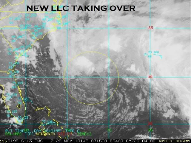
That's the problem there is not a single dominant LLC with this system, its just 3-4 eddy circulations rotating around a very large broad circulation, thats not the type of set-up that will normally see an upgrade.


Precisely. There isn't any well-defined center other than the center of the broad low that has those small insignificant eddies rotating around. There is some convection to the north of the broad low now, though, a sign that shear may be letting up a bit. But this system has quite a long ways to go to become Alex. Earliest possibly tomorrow night if it could develop convection over a center and have that convection persist. But by Wednesday, the low starts moving off to the NE over cooler water.
0 likes   

User avatar
wxman57
Moderator-Pro Met
Moderator-Pro Met
Posts: 22951
Age: 67
Joined: Sat Jun 21, 2003 8:06 pm
Location: Houston, TX (southwest)

Re: ATL : INVEST 90L=CODE ORANGE

#245 Postby wxman57 » Mon May 24, 2010 5:12 pm

MGC wrote:I don't see how 90L warrents code orange. 90L is a big mess with too much shear and dry air to get going right now. Perhaps in a couple of days conditions might improve.......MGC


Look at it this way, the NHC is now defining the probability of development to the nearest 10%. This "code orange" is a 30% chance of development over the next 48 hrs. That's a 70% chance it won't develop during that time. I'd say that is a fair estimate.
0 likes   

User avatar
Hurricane Andrew
S2K Supporter
S2K Supporter
Posts: 1891
Age: 26
Joined: Sun May 23, 2010 2:53 pm
Location: KS

#246 Postby Hurricane Andrew » Mon May 24, 2010 5:19 pm

I opened a INVEST 90L contest if you guys want to participate. It's in the contest forums.
0 likes   

The Enthusiast
NREMT-AEMT, WX nerd

Irene '11, Sandy '12, Irma '17 (SAR)

"Hard to think we were born to live this way..." -Wage War

User avatar
Annie Oakley
Category 5
Category 5
Posts: 1103
Joined: Tue Jul 31, 2007 12:54 pm
Location: Texas

Re:

#247 Postby Annie Oakley » Mon May 24, 2010 5:34 pm

Hurricane Andrew wrote:I opened a INVEST 90L contest if you guys want to participate. It's in the contest forums.

Hi Andrew-could you post the link for that please? Thanks in advance!
0 likes   

User avatar
Hurricane Andrew
S2K Supporter
S2K Supporter
Posts: 1891
Age: 26
Joined: Sun May 23, 2010 2:53 pm
Location: KS

#248 Postby Hurricane Andrew » Mon May 24, 2010 6:36 pm

0 likes   

The Enthusiast
NREMT-AEMT, WX nerd

Irene '11, Sandy '12, Irma '17 (SAR)

"Hard to think we were born to live this way..." -Wage War

User avatar
cycloneye
Admin
Admin
Posts: 143871
Age: 68
Joined: Thu Oct 10, 2002 10:54 am
Location: San Juan, Puerto Rico

Re: ATL : INVEST 90L=CODE ORANGE

#249 Postby cycloneye » Mon May 24, 2010 6:44 pm

Downgraded to Code Yellow

ABNT20 KNHC 242341
TWOAT
SPECIAL TROPICAL WEATHER OUTLOOK
NWS TPC/NATIONAL HURRICANE CENTER MIAMI FL
745 PM EDT MON MAY 24 2010

FOR THE NORTH ATLANTIC...CARIBBEAN SEA AND THE GULF OF MEXICO...

THE NON-TROPICAL LOW PRESSURE SYSTEM CENTERED BETWEEN BERMUDA AND
THE BAHAMAS REMAINS DISORGANIZED...AND THE POTENTIAL TO ACQUIRE
SUBTROPICAL CHARACTERISTICS DURING THE NEXT DAY OR SO IS
DIMINISHING. THERE IS A LOW CHANCE...20 PERCENT...OF THIS SYSTEM
BECOMING A SUBTROPICAL CYCLONE DURING THE NEXT 48 HOURS. THIS LOW
IS MOVING SLOWLY TOWARD THE NORTH-NORTHWEST AND IS STILL PRODUCING
A LARGE AREA OF SHOWERS AND THUNDERSTORMS ALONG WITH GALE FORCE
WINDS. FOR ADDITIONAL INFORMATION...PLEASE SEE HIGH SEAS FORECASTS
ISSUED BY THE NATIONAL WEATHER SERVICE...UNDER AWIPS HEADER
NFDHSFAT1 AND WMO HEADER FZNT01 KWBC. NO FURTHER SPECIAL TROPICAL
WEATHER OUTLOOKS ON THIS SYSTEM ARE ANTICIPATED.
$$

FORECASTER AVILA/BLAKE

Image
0 likes   
Visit the Caribbean-Central America Weather Thread where you can find at first post web cams,radars
and observations from Caribbean basin members Click Here

User avatar
Aquawind
Category 5
Category 5
Posts: 6714
Age: 61
Joined: Mon Jun 16, 2003 10:41 pm
Location: Salisbury, NC
Contact:

#250 Postby Aquawind » Mon May 24, 2010 6:57 pm

YAY!! VERY low chance of development..still be careful playing in the water..
0 likes   

User avatar
srainhoutx
S2K Supporter
S2K Supporter
Posts: 6919
Age: 67
Joined: Sun Jan 14, 2007 11:34 am
Location: Haywood County, NC
Contact:

Re: ATL : INVEST 90L=CODE YELLOW

#251 Postby srainhoutx » Mon May 24, 2010 7:27 pm

About time 'bones' showed up... :wink:
0 likes   
Carla/Alicia/Jerry(In The Eye)/Michelle/Charley/Ivan/Dennis/Katrina/Rita/Wilma/Ike/Harvey

Member: National Weather Association
Wx Infinity Forums
http://wxinfinity.com/index.php

Facebook.com/WeatherInfinity
Twitter @WeatherInfinity

User avatar
MGC
S2K Supporter
S2K Supporter
Posts: 5885
Joined: Sun Mar 23, 2003 9:05 pm
Location: Pass Christian MS, or what is left.

Re: ATL : INVEST 90L=CODE YELLOW

#252 Postby MGC » Mon May 24, 2010 8:15 pm

Glad the NHC agrees with me!.......MGC
0 likes   

User avatar
HURAKAN
Professional-Met
Professional-Met
Posts: 46086
Age: 38
Joined: Thu May 20, 2004 4:34 pm
Location: Key West, FL
Contact:

Re: ATL : INVEST 90L=CODE YELLOW

#253 Postby HURAKAN » Mon May 24, 2010 8:28 pm

00z

AL, 90, 2010052500, , BEST, 0, 280N, 704W, 40, 1007, LO
0 likes   

User avatar
HURAKAN
Professional-Met
Professional-Met
Posts: 46086
Age: 38
Joined: Thu May 20, 2004 4:34 pm
Location: Key West, FL
Contact:

#254 Postby HURAKAN » Mon May 24, 2010 8:30 pm

I also agree with the NHC that the chances are low but I wouldn't kill it before it's dead. I would like to see how it responds in the next 48 hours to lower shear values and the Gulf Stream.
0 likes   

User avatar
HURAKAN
Professional-Met
Professional-Met
Posts: 46086
Age: 38
Joined: Thu May 20, 2004 4:34 pm
Location: Key West, FL
Contact:

#255 Postby HURAKAN » Mon May 24, 2010 8:57 pm

Image

48 hours
0 likes   

User avatar
wxman57
Moderator-Pro Met
Moderator-Pro Met
Posts: 22951
Age: 67
Joined: Sat Jun 21, 2003 8:06 pm
Location: Houston, TX (southwest)

Re: ATL : INVEST 90L=CODE YELLOW

#256 Postby wxman57 » Mon May 24, 2010 9:01 pm

Models have always predicted that it would reach peak strength tomorrow night/Wednesday. But it's looking like it won't reach the organization level necessary for naming.
0 likes   

User avatar
HURAKAN
Professional-Met
Professional-Met
Posts: 46086
Age: 38
Joined: Thu May 20, 2004 4:34 pm
Location: Key West, FL
Contact:

#257 Postby HURAKAN » Mon May 24, 2010 9:44 pm

Image

NHC pulling the plugs
0 likes   

User avatar
HURAKAN
Professional-Met
Professional-Met
Posts: 46086
Age: 38
Joined: Thu May 20, 2004 4:34 pm
Location: Key West, FL
Contact:

#258 Postby HURAKAN » Mon May 24, 2010 11:07 pm

Image
0 likes   

jaxfladude
Category 5
Category 5
Posts: 1249
Joined: Wed Aug 24, 2005 9:36 pm
Location: Jacksonville, Fla

Re:

#259 Postby jaxfladude » Mon May 24, 2010 11:35 pm

HURAKAN wrote:..................
NHC pulling the plugs


Just pull the plug on the season NHC!
Do not like the set up STORM2K Forums is talking about of late for the upcoming hurricane season.
"Storm Cancel" is fine with me.
0 likes   

User avatar
HURAKAN
Professional-Met
Professional-Met
Posts: 46086
Age: 38
Joined: Thu May 20, 2004 4:34 pm
Location: Key West, FL
Contact:

#260 Postby HURAKAN » Mon May 24, 2010 11:55 pm

Image

Good pic
0 likes   


Return to “2010”

Who is online

Users browsing this forum: No registered users and 57 guests