ENSO Updates (2007 thru 2023)

This is the general tropical discussion area. Anyone can take their shot at predicting a storms path.

Moderator: S2k Moderators

Forum rules

The posts in this forum are NOT official forecasts and should not be used as such. They are just the opinion of the poster and may or may not be backed by sound meteorological data. They are NOT endorsed by any professional institution or STORM2K. For official information, please refer to products from the National Hurricane Center and National Weather Service.

Help Support Storm2K
Message
Author
User avatar
cycloneye
Admin
Admin
Posts: 145299
Age: 68
Joined: Thu Oct 10, 2002 10:54 am
Location: San Juan, Puerto Rico

Re: ENSO Updates

#1441 Postby cycloneye » Thu Jun 03, 2010 11:39 am

Climate Prediction Center June Update=La Nina by June-August timeframe

Is getting cold very fast in the ENSO areas.

http://www.cpc.ncep.noaa.gov/products/a ... odisc.html


Synopsis: Conditions are favorable for a transition to La Niña conditions during June – August 2010.

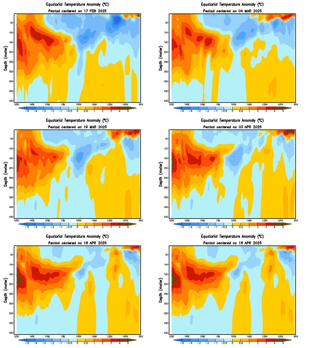
El Niño dissipated during May 2010 as positive surface temperature (SST) anomalies decreased rapidly across the equatorial Pacific Ocean and negative SST anomalies emerged across the eastern half of the Pacific (Fig. 1). All of the Niño indices decreased between 0.5oC to 1.0oC during the month (Fig. 2). Since the end of February, subsurface heat content anomalies (average temperatures in the upper 300m of the ocean, Fig. 3) have decreased steadily. Below-average temperatures have strengthened at depth and currently extend to the surface in parts of the eastern Pacific (Fig. 4). Also during May, enhanced convection persisted over Indonesia, while the area of suppressed convection strengthened and expanded over the tropical central Pacific (Fig. 5). The low-level easterly trade winds strengthened over the western and central equatorial Pacific, and anomalous upper-level westerly winds prevailed over the east-central Pacific. Collectively, these oceanic and atmospheric anomalies reflect the demise of El Niño and return of ENSO-neutral conditions.

The majority of models predict ENSO-neutral conditions (between -0.5oC to +0.5oC in the Niño-3.4 region) through early 2011 (Fig. 6). However, over the last several months, a growing number of models, including the NCEP Climate Forecast System (CFS), indicate the onset of La Niña conditions during June-August 2010. There is an increasing confidence in these colder model forecasts, which is supported by recent observations that show cooling trends in the Pacific Ocean and signs of coupling with the atmospheric circulation. Therefore, conditions are favorable for a transition to La Niña conditions during June-August 2010

0 likes   
Visit the Caribbean-Central America Weather Thread where you can find at first post web cams,radars
and observations from Caribbean basin members Click Here

User avatar
cycloneye
Admin
Admin
Posts: 145299
Age: 68
Joined: Thu Oct 10, 2002 10:54 am
Location: San Juan, Puerto Rico

Re: ENSO Updates=CPC 6/3/10 Montly=La Nina by June-August

#1442 Postby cycloneye » Thu Jun 03, 2010 12:27 pm

Here she comes:

Image
0 likes   
Visit the Caribbean-Central America Weather Thread where you can find at first post web cams,radars
and observations from Caribbean basin members Click Here

User avatar
Hybridstorm_November2001
S2K Supporter
S2K Supporter
Posts: 2811
Joined: Sat Aug 21, 2004 2:50 pm
Location: SW New Brunswick, Canada
Contact:

#1443 Postby Hybridstorm_November2001 » Thu Jun 03, 2010 12:43 pm

Sounds about right to me. Looking at the data I've been thinking it'll be here by around July 1st for the past three months.
0 likes   

User avatar
cycloneye
Admin
Admin
Posts: 145299
Age: 68
Joined: Thu Oct 10, 2002 10:54 am
Location: San Juan, Puerto Rico

Re: ENSO Updates=CPC June Update=La Nina by June-August

#1444 Postby cycloneye » Thu Jun 03, 2010 1:09 pm

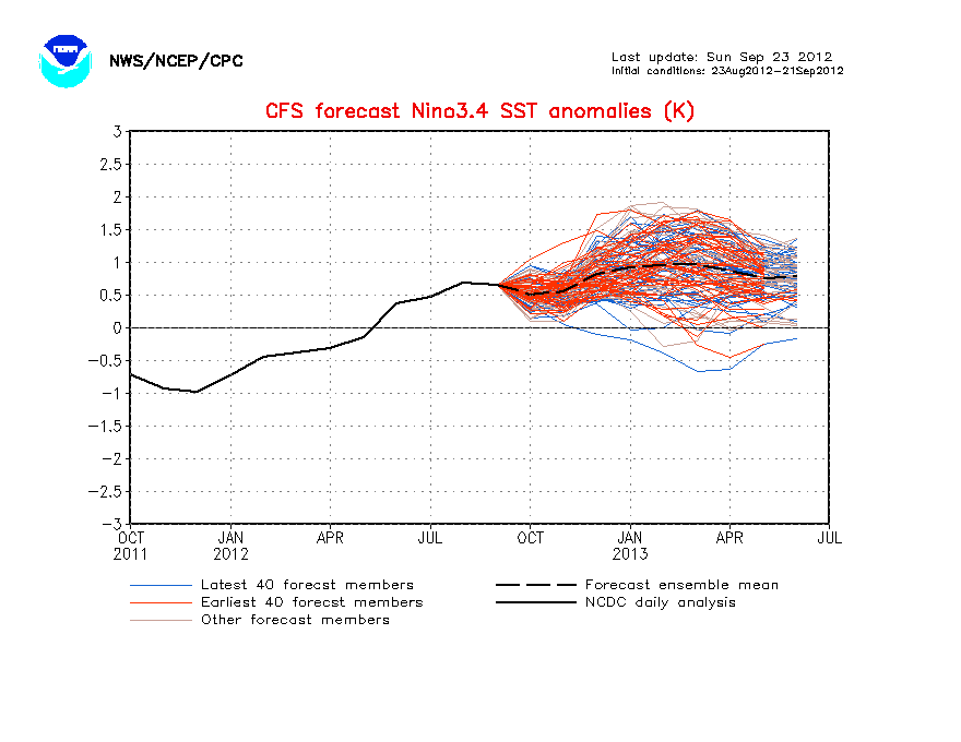
Wow,the CFS (NCEP) model goes even further down and now forecasts a Moderate to Strong La Nina.And as we know if that is the case and it materilize,it could mean a somewhat lesser active season but with tracks to the south.

http://www.cpc.ncep.noaa.gov/products/a ... cast.shtml


Image
0 likes   
Visit the Caribbean-Central America Weather Thread where you can find at first post web cams,radars
and observations from Caribbean basin members Click Here

User avatar
KWT
Category 5
Category 5
Posts: 31415
Joined: Tue Aug 17, 2004 11:02 am
Location: UK!!!

#1445 Postby KWT » Thu Jun 03, 2010 1:58 pm

Wll if a La Nina gets that strong then it might just save us from an insane season that would probably occur with a weaker La Nina set-up.

Its quite possible the CFS model is doing what it normally does and extrapolating the recent cooling rates too far, but we shall see!
0 likes   
Personal Forecast Disclaimer:
The posts in this forum are NOT official forecast and should not be used as such. They are just the opinion of the poster and may or may not be backed by sound meteorological data. They are NOT endorsed by any professional institution or storm2k.org. For official information, please refer to the NHC and NWS products

HURRICANELONNY
Category 5
Category 5
Posts: 1383
Joined: Wed May 07, 2003 6:48 am
Location: HOLLYWOOD.FL

Re: ENSO Updates=CPC June Update=La Nina by June-August

#1446 Postby HURRICANELONNY » Thu Jun 03, 2010 4:34 pm

It does seem that neutral with high SST's as 2005 was. Brings more #'s then La Nina would. I'm hoping for a strong La Nina to hopefully bring down the #'s. It's like throwing darts. The more darts you have. The more likely you'll hit the bulls eye. I think there will be huge Hurricanes like Floyd. But more like 15 names. Then over 20. But what do I know. :roll:
0 likes   
hurricanelonny

Duffy1966
Tropical Low
Tropical Low
Posts: 12
Joined: Tue Aug 14, 2007 7:25 pm

Re: ENSO Updates=CPC June Update=La Nina by June-August

#1447 Postby Duffy1966 » Thu Jun 03, 2010 5:37 pm

HURRICANELONNY wrote:It does seem that neutral with high SST's as 2005 was. Brings more #'s then La Nina would. I'm hoping for a strong La Nina to hopefully bring down the #'s. It's like throwing darts. The more darts you have. The more likely you'll hit the bulls eye. I think there will be huge Hurricanes like Floyd. But more like 15 names. Then over 20. But what do I know. :roll:

Why does a Stronger La Nina mean fewer Storms?
0 likes   

HurricaneJoe22
Category 1
Category 1
Posts: 456
Joined: Wed Sep 08, 2004 12:45 am
Location: Temple, Texas

Re: ENSO Updates=CPC June Update=La Nina by June-August

#1448 Postby HurricaneJoe22 » Thu Jun 03, 2010 5:39 pm

punctuation fail
0 likes   

User avatar
gatorcane
S2K Supporter
S2K Supporter
Posts: 23691
Age: 47
Joined: Sun Mar 13, 2005 3:54 pm
Location: Boca Raton, FL

Re:

#1449 Postby gatorcane » Thu Jun 03, 2010 6:54 pm

KWT wrote:Wll if a La Nina gets that strong then it might just save us from an insane season that would probably occur with a weaker La Nina set-up.

Its quite possible the CFS model is doing what it normally does and extrapolating the recent cooling rates too far, but we shall see!


Don't forget that we have much warmer SSTs than normal all across the Atlantic this year so if a La Nina forms, then I'm not so sure that would really put a cap on the number of systems. In fact if you look at the latest NOAA outlook, the presence of La Nina is what could allow us to hit the MAX number of systems in the range.
0 likes   

User avatar
KWT
Category 5
Category 5
Posts: 31415
Joined: Tue Aug 17, 2004 11:02 am
Location: UK!!!

#1450 Postby KWT » Thu Jun 03, 2010 7:14 pm

Well that is of course a factor, 1998 is the only year that had a mod la Nina but also had decently above average SSTs and that ended up at 14...This season won't end up as low as that I'd imagine but the MJO waves tend to be constricted in decent La Ninas.

As for the idea that the La Nina helps us to hit the max NS, I simply refer you to the simple fact that neutral seasons have had more NS then La Nina years in this warm phase...If we get to around -1C, I'm pretty confident your not going to get to 20, indeed you'll probably be closer to 15 than 20.

Thr NOAA outlook is the basic idea that La Nina allows for higher numbers, it hasn't in the recent past, it probably does promote a higher ACE index however which suggests longer lasting storms and I think that would be the case this year if the La Nina gets decently strong, a couple of big long lasting majors probably. I think the reason 2005 went sky high was because we really didn't have many of those big long trackers, they all developed and had fairly short tracsk (bar a couple of September systems and Emily) which helped to perserve that heat content for later in the season.

Of course this season is going to be a very good test for this whole idea, because other conditions really do suggest a top 3 type season, and even though I'm expecting a low end moderate eventually I'm still calling for 17NS which is way above the normal and only rivalled by a few.

Besides, I like the ACE index far more then the pure numbers anyway, much better reflects the season as a whole IMO. I think we will probably be pushing 200 once all is done with this year, La Ninas tend to generally end up between 165-200 though 1995 obviously went higher then that as did 1955.

Watch this season prove this a load of tosh...but I think Joe B is spot on with his range of 16-18.
0 likes   
Personal Forecast Disclaimer:
The posts in this forum are NOT official forecast and should not be used as such. They are just the opinion of the poster and may or may not be backed by sound meteorological data. They are NOT endorsed by any professional institution or storm2k.org. For official information, please refer to the NHC and NWS products

User avatar
johngaltfla
Category 5
Category 5
Posts: 2069
Joined: Sun Jul 10, 2005 9:17 pm
Location: Sarasota County, FL
Contact:

Re: Re:

#1451 Postby johngaltfla » Thu Jun 03, 2010 7:45 pm

gatorcane wrote:
KWT wrote:Wll if a La Nina gets that strong then it might just save us from an insane season that would probably occur with a weaker La Nina set-up.

Its quite possible the CFS model is doing what it normally does and extrapolating the recent cooling rates too far, but we shall see!


Don't forget that we have much warmer SSTs than normal all across the Atlantic this year so if a La Nina forms, then I'm not so sure that would really put a cap on the number of systems. In fact if you look at the latest NOAA outlook, the presence of La Nina is what could allow us to hit the MAX number of systems in the range.


That's why my number of named storms was so high. We may see a lot of fish, but the more storms we see, the greater the odds that one or two impact the U.S. My fear is for those beautiful islands in the Caribbean which I would hate to see impacted again, but fear they will not be.
0 likes   

User avatar
cycloneye
Admin
Admin
Posts: 145299
Age: 68
Joined: Thu Oct 10, 2002 10:54 am
Location: San Juan, Puerto Rico

Re: ENSO Updates

#1452 Postby cycloneye » Sun Jun 06, 2010 9:31 am

This transition from El Nino to La Nina with Neutral being there only for a short period is not seen often.

Image
0 likes   
Visit the Caribbean-Central America Weather Thread where you can find at first post web cams,radars
and observations from Caribbean basin members Click Here

User avatar
cycloneye
Admin
Admin
Posts: 145299
Age: 68
Joined: Thu Oct 10, 2002 10:54 am
Location: San Juan, Puerto Rico

Re: ENSO Updates=CPC 6/7/10 weekly update shortly

#1453 Postby cycloneye » Mon Jun 07, 2010 8:02 am

You can see in only a timeframe of one month,how the colder waters have expanded thru the equatorial Pacific.

May 6 2010

Image

June 7 2010

Image
0 likes   
Visit the Caribbean-Central America Weather Thread where you can find at first post web cams,radars
and observations from Caribbean basin members Click Here

User avatar
cycloneye
Admin
Admin
Posts: 145299
Age: 68
Joined: Thu Oct 10, 2002 10:54 am
Location: San Juan, Puerto Rico

Re: ENSO=CPC 6/7/10 weekly update=Nino 3.4 down to -0.4C

#1454 Postby cycloneye » Mon Jun 07, 2010 8:14 am

Climate Prediction Center 6/7/10 Weekly Update

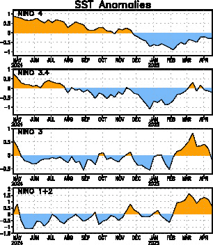
According to this update,Neutral ENSO may not be for too long in the equatorial Pacific as the data shows the falling of the numbers in almost all El Nino areas continues with El Nino 3.4 down to -0.4,only .1 above the threshold to be in La Nina territory.

Last Week Numbers

Niño 4= -0.4C
Niño 3.4= -0.2C
Niño 3= -0.4C
Niño1+2= -0.6C

This Week Numbers

Niño 4 +0.2C
Niño 3.4 -0.4C
Niño 3 -0.5C
Niño1+2 -0.2C

http://www.cpc.ncep.noaa.gov/products/a ... ts-web.pdf

Image
0 likes   
Visit the Caribbean-Central America Weather Thread where you can find at first post web cams,radars
and observations from Caribbean basin members Click Here

User avatar
wxman57
Moderator-Pro Met
Moderator-Pro Met
Posts: 22978
Age: 67
Joined: Sat Jun 21, 2003 8:06 pm
Location: Houston, TX (southwest)

Re: ENSO=CPC 6/7/10 weekly update=Nino 3.4 down to -0.4C

#1455 Postby wxman57 » Mon Jun 07, 2010 8:52 am

Question - where can I get these weekly numbers so that I can plot my own trace of the SST anomaly? I need to make a simple graphic showing temperature change in the Pacific.
0 likes   

User avatar
MHurricanes
Tropical Storm
Tropical Storm
Posts: 102
Age: 73
Joined: Thu Aug 14, 2008 2:05 pm
Location: Altamonte Springs, FL
Contact:

Re: ENSO=CPC 6/7/10 weekly update=Nino 3.4 down to -0.4C

#1456 Postby MHurricanes » Mon Jun 07, 2010 8:55 am

Joe Bastardi believes its the North Atlantic Tripole that is more important to this year's hurricane season than the existence of neutral, La Nina or El Nino conditions ("unless it's a raging El Nino"). His comments are here:

http://www.accuweather.com/video/88702593001/the-la-nina-is-not-the-driving-force-for-this-season.asp?channel=vblog_bastardi
0 likes   

User avatar
cycloneye
Admin
Admin
Posts: 145299
Age: 68
Joined: Thu Oct 10, 2002 10:54 am
Location: San Juan, Puerto Rico

Re: ENSO=CPC 6/7/10 weekly update=Nino 3.4 down to -0.4C

#1457 Postby cycloneye » Mon Jun 07, 2010 9:02 am

wxman57 wrote:Question - where can I get these weekly numbers so that I can plot my own trace of the SST anomaly? I need to make a simple graphic showing temperature change in the Pacific.


In the link to CPC there are no archieves but you can go back thru the pages of this thread from this one backwards to get the past numbers from the past updates that I have posted.
0 likes   
Visit the Caribbean-Central America Weather Thread where you can find at first post web cams,radars
and observations from Caribbean basin members Click Here

User avatar
cycloneye
Admin
Admin
Posts: 145299
Age: 68
Joined: Thu Oct 10, 2002 10:54 am
Location: San Juan, Puerto Rico

Re: ENSO=CPC 6/7/10 weekly update=Nino 3.4 down to -0.4C

#1458 Postby cycloneye » Mon Jun 07, 2010 9:07 am

MHurricanes wrote:Joe Bastardi believes its the North Atlantic Tripole that is more important to this year's hurricane season than the existence of neutral, La Nina or El Nino conditions ("unless it's a raging El Nino"). His comments are here:

http://www.accuweather.com/video/88702593001/the-la-nina-is-not-the-driving-force-for-this-season.asp?channel=vblog_bastardi


For those members that dont know where is the tripole,is warm in deep tropics,cold at subtropical Atlantic and warm in the north Atlantic.

Image
0 likes   
Visit the Caribbean-Central America Weather Thread where you can find at first post web cams,radars
and observations from Caribbean basin members Click Here

User avatar
cycloneye
Admin
Admin
Posts: 145299
Age: 68
Joined: Thu Oct 10, 2002 10:54 am
Location: San Juan, Puerto Rico

Re: ENSO=CPC 6/7/10 weekly update=Nino 3.4 down to -0.4C

#1459 Postby cycloneye » Mon Jun 07, 2010 3:44 pm

Image
0 likes   
Visit the Caribbean-Central America Weather Thread where you can find at first post web cams,radars
and observations from Caribbean basin members Click Here

User avatar
cycloneye
Admin
Admin
Posts: 145299
Age: 68
Joined: Thu Oct 10, 2002 10:54 am
Location: San Juan, Puerto Rico

Re: ENSO Updates

#1460 Postby cycloneye » Tue Jun 08, 2010 1:30 pm

Here is Dr Jeff Masters discussion about the growing posibility of having La Nina by July.His analog is 1998 and I agree that 98 looks very good right now.

Posted by: JeffMasters, 1:42 PM GMT on June 08, 2010

El Niño rapidly dissipated in May, and we are now very close to entering into a La Niña event, according to the latest sea surface temperature (SST) data over the tropical Eastern Pacific. The weekly SST readings in the area 5°N - 5°S, 120°W - 170°W, also called the "Niña 3.4 region", fell to 0.4°C below average on June 7, a full 1°C drop in just one and a half months. This puts us very close to the -0.5°C threshold needed to be considered a La Niña event, according to NOAA's latest El Niño Discussion. The Australian Bureau of Meteorology showed conditions in the Niña 3.4 region were not quite that cool--0.2°C below average for the week ending June 6. Nevertheless, the speed of the collapse of El Niño makes it likely that a La Niña event is on its way this summer, and NOAA's Climate Prediction Center has issued a La Niña watch. Ten of the 23 El Niño models (updated as of May 19) are predicting La Niña conditions for hurricane season. However, as NOAA's Climate Prediction Center commented in their June 3 advisory, a number of the more reliable models are now calling for La Niña to develop this summer. They comment, "there is an increasing confidence in these colder model forecasts, which is supported by recent observations that show cooling trends in the Pacific Ocean and signs of coupling with the atmospheric circulation." Historically, about 35 - 40% of El Niño events are followed by a La Niña within the same year.

It is interesting to note that the last time we had a strong El Niño event, in 1998, El Niño collapsed dramatically in May, and a strong La Niña event developed by hurricane season. History appears to be repeating itself, and I predict the emergence of La Niña by July. Since La Niña events tend to bring lower amounts of wind shear to the tropical Atlantic, we can expect a much more active Atlantic hurricane season than usual in 2010. Since 2010 is similar to 1998 in the behavior of the El Niño/La Niña cycle, it is possible that this year's hurricane season could resemble the 1998 Atlantic hurricane season. That year had about 40% above-average activity, with 14 named storms, 10 hurricanes, and 3 intense hurricanes. The season was relatively late-starting, with only one named storm occurring before August 20. Once the season got going, six named storms affected the Gulf of Mexico, including two hurricanes, Earl and Georges, that passed directly over the location of the Deepwater Horizon oil spill.


Image
Image
0 likes   
Visit the Caribbean-Central America Weather Thread where you can find at first post web cams,radars
and observations from Caribbean basin members Click Here


Return to “Talkin' Tropics”

Who is online

Users browsing this forum: No registered users and 18 guests