
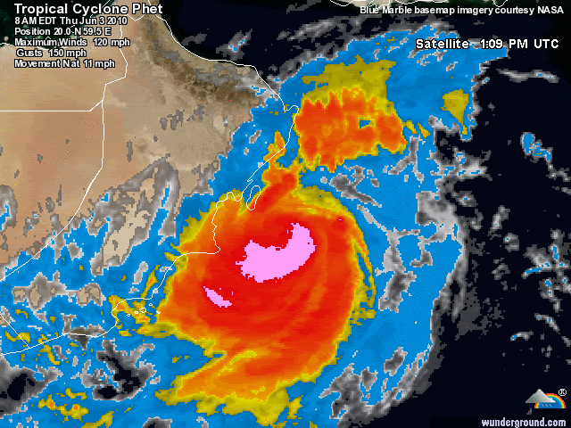
Masirah Airport sustained at 74 mph on the latest obs.
http://www.wunderground.com/cgi-bin/fin ... ct=WEATHER
ARABIAN SEA - DEEP DEPRESSION (03A)
Moderator: S2k Moderators


-
Derek Ortt


Yeah Derek I agree, there was a time where it was probably down to about 80-85kts but it has re-organised itself again today to some degree and looks much better today.
Will be interesting to see if we see some strengthening as it heads ENE/NE, the JWTC expect weakening but these systems on a ENE heading can sometimes pull surprises.
Will be interesting to see if we see some strengthening as it heads ENE/NE, the JWTC expect weakening but these systems on a ENE heading can sometimes pull surprises.
0 likes
Personal Forecast Disclaimer:
The posts in this forum are NOT official forecast and should not be used as such. They are just the opinion of the poster and may or may not be backed by sound meteorological data. They are NOT endorsed by any professional institution or storm2k.org. For official information, please refer to the NHC and NWS products
The posts in this forum are NOT official forecast and should not be used as such. They are just the opinion of the poster and may or may not be backed by sound meteorological data. They are NOT endorsed by any professional institution or storm2k.org. For official information, please refer to the NHC and NWS products


Re: ARABIAN SEA -VERY SEVERE CYCLONIC STORM PHET (03A)
0 likes

Northern eyewall looks like its having a hard time, the system is very much open in terms of the eyewall right now thats for sure!
0 likes
Personal Forecast Disclaimer:
The posts in this forum are NOT official forecast and should not be used as such. They are just the opinion of the poster and may or may not be backed by sound meteorological data. They are NOT endorsed by any professional institution or storm2k.org. For official information, please refer to the NHC and NWS products
The posts in this forum are NOT official forecast and should not be used as such. They are just the opinion of the poster and may or may not be backed by sound meteorological data. They are NOT endorsed by any professional institution or storm2k.org. For official information, please refer to the NHC and NWS products


Re: ARABIAN SEA -VERY SEVERE CYCLONIC STORM PHET (03A)
The cyclone is expected to be in Omani land until the end of Saturday according to the model output from King Abdulaziz University, Jeddah, Saudi Arabia:
http://weather.kau.edu.sa/content.aspx? ... &cid=39987
For rainfall
http://weather.kau.edu.sa/Pages-%D8%A7% ... D8%B1.aspx
For 500 mb charts
http://weather.kau.edu.sa/Pages-طبقات-الجو-العليا-مستوى-500.aspx
According to the Met Office Authority in Oman, Masirah Island recorded 99 mm rainfall and wind of 150 km/hr. Since the morning wind was very strong and sustain for long in that speed.
As it is now (21:00GMT):
Masirah Island is having heavy rainfall, but wind is weakening at this time than previously, Wadis are flooding. Electricity is still down
Sur (a coastal station) in the Eastern province (Al-Sharqyah) is having heavy shower, it is expected to increasing in the coming hours.
Some coastal cities in the Eastern Province (North Eastern coast from Masirah Island) are facing heavy rainfall and electricity down, these cities may face the touchdown of the cyclone.
Mahawt coastal city western side of Masirah Island experienced heavy rainfall but expected to ease down.
0 likes

Re: ARABIAN SEA -VERY SEVERE CYCLONIC STORM PHET (03A)
WTIO31 PGTW 032100
MSGID/GENADMIN/NAVMARFCSTCEN PEARL HARBOR HI/JTWC//
SUBJ/TROPICAL CYCLONE 03A (PHET) WARNING NR 013//
RMKS/
1. TROPICAL CYCLONE 03A (PHET) WARNING NR 013
01 ACTIVE TROPICAL CYCLONE IN NORTHIO
MAX SUSTAINED WINDS BASED ON ONE-MINUTE AVERAGE
WIND RADII VALID OVER OPEN WATER ONLY
---
WARNING POSITION:
031800Z --- NEAR 20.8N 59.2E
MOVEMENT PAST SIX HOURS - 340 DEGREES AT 08 KTS
POSITION ACCURATE TO WITHIN 040 NM
POSITION BASED ON EYE FIXED BY SATELLITE
PRESENT WIND DISTRIBUTION:
MAX SUSTAINED WINDS - 105 KT, GUSTS 130 KT
WIND RADII VALID OVER OPEN WATER ONLY
RADIUS OF 064 KT WINDS - 045 NM NORTHEAST QUADRANT
045 NM SOUTHEAST QUADRANT
045 NM SOUTHWEST QUADRANT
045 NM NORTHWEST QUADRANT
RADIUS OF 050 KT WINDS - 085 NM NORTHEAST QUADRANT
070 NM SOUTHEAST QUADRANT
070 NM SOUTHWEST QUADRANT
085 NM NORTHWEST QUADRANT
RADIUS OF 034 KT WINDS - 100 NM NORTHEAST QUADRANT
090 NM SOUTHEAST QUADRANT
095 NM SOUTHWEST QUADRANT
115 NM NORTHWEST QUADRANT
REPEAT POSIT: 20.8N 59.2E
---
FORECASTS:
12 HRS, VALID AT:
040600Z --- 21.8N 58.9E
MAX SUSTAINED WINDS - 090 KT, GUSTS 110 KT
WIND RADII VALID OVER OPEN WATER ONLY
VECTOR TO 24 HR POSIT: 010 DEG/ 03 KTS
---
24 HRS, VALID AT:
041800Z --- 22.4N 59.0E
MAX SUSTAINED WINDS - 070 KT, GUSTS 085 KT
WIND RADII VALID OVER OPEN WATER ONLY
VECTOR TO 36 HR POSIT: 055 DEG/ 03 KTS
---
36 HRS, VALID AT:
050600Z --- 22.7N 59.5E
MAX SUSTAINED WINDS - 065 KT, GUSTS 080 KT
WIND RADII VALID OVER OPEN WATER ONLY
RADIUS OF 050 KT WINDS - 025 NM NORTHEAST QUADRANT
025 NM SOUTHEAST QUADRANT
025 NM SOUTHWEST QUADRANT
025 NM NORTHWEST QUADRANT
RADIUS OF 034 KT WINDS - 050 NM NORTHEAST QUADRANT
055 NM SOUTHEAST QUADRANT
035 NM SOUTHWEST QUADRANT
040 NM NORTHWEST QUADRANT
VECTOR TO 48 HR POSIT: 070 DEG/ 07 KTS
---
EXTENDED OUTLOOK:
48 HRS, VALID AT:
051800Z --- 23.2N 60.9E
MAX SUSTAINED WINDS - 065 KT, GUSTS 080 KT
WIND RADII VALID OVER OPEN WATER ONLY
RADIUS OF 050 KT WINDS - 025 NM NORTHEAST QUADRANT
025 NM SOUTHEAST QUADRANT
025 NM SOUTHWEST QUADRANT
025 NM NORTHWEST QUADRANT
RADIUS OF 034 KT WINDS - 050 NM NORTHEAST QUADRANT
055 NM SOUTHEAST QUADRANT
040 NM SOUTHWEST QUADRANT
040 NM NORTHWEST QUADRANT
VECTOR TO 72 HR POSIT: 070 DEG/ 10 KTS
---
72 HRS, VALID AT:
061800Z --- 24.4N 64.9E
MAX SUSTAINED WINDS - 055 KT, GUSTS 070 KT
WIND RADII VALID OVER OPEN WATER ONLY
DISSIPATING AS A SIGNIFICANT TROPICAL CYCLONE OVER WATER
RADIUS OF 050 KT WINDS - 020 NM NORTHEAST QUADRANT
020 NM SOUTHEAST QUADRANT
020 NM SOUTHWEST QUADRANT
020 NM NORTHWEST QUADRANT
RADIUS OF 034 KT WINDS - 050 NM NORTHEAST QUADRANT
055 NM SOUTHEAST QUADRANT
045 NM SOUTHWEST QUADRANT
040 NM NORTHWEST QUADRANT
VECTOR TO 96 HR POSIT: 060 DEG/ 13 KTS
---
LONG RANGE OUTLOOK:
NOTE...ERRORS FOR TRACK HAVE AVERAGED NEAR 250 NM
ON DAY 4 AND 350 NM ON DAY 5... AND FOR INTENSITY
NEAR 20 KT EACH DAY.
---
96 HRS, VALID AT:
071800Z --- 27.2N 70.0E
MAX SUSTAINED WINDS - 025 KT, GUSTS 035 KT
WIND RADII VALID OVER OPEN WATER ONLY
DISSIPATED AS A SIGNIFICANT TROPICAL CYCLONE OVER LAND
---
REMARKS:
032100Z POSITION NEAR 21.1N 59.1E.
TROPICAL CYCLONE (TC) 03A (PHET), LOCATED APPROXIMATELY 170 NM SOUTH-
SOUTHEAST OF MUSCAT, OMAN, HAS TRACKED NORTH-NORTHWESTWARD AT 08
KNOTS OVER THE PAST SIX HOURS. ANIMATED INFRARED SATELLITE IMAGERY
SHOWS TC 03A HAS MOVED TO THE WEST OF THE PREVIOUSLY FORECASTED TRACK
AND HAS MAINTAINED TRACK SPEED OVER THE PAST SIX HOURS. BASED ON AN
EYE FEATURE PRESENT IN AVAILABLE SATELLITE IMAGERY, TC 03A IS CUR-
RENTLY MAKING LANDFALL IN SOUTHEASTERN OMAN. THE CURRENT FORECAST
TRACK KEEPS PHET MOVING SLOWLY POLEWARD THROUGH THE EASTERN PORTION
OF OMAN FOR THE NEXT 24 TO 36 HOURS TOWARD THE BASE OF A SLOWLY-
MOVING MID-LATITUDE TROUGH, ANALYZED TO THE NORTH AND EAST OF THE
CYCLONE. AS THE TROUGH MOVES OUT, AN INDUCED RIDGE TO THE EAST OF TC
03A WILL BEGIN TO RE-ORIENT AND EVENTUALLY BECOME THE DOMINANT
STEERING INFLUENCE. THEREAFTER, A SECONDARY MID-LATITUDE TROUGH WILL
DEVELOP AND APPROACH THE CYCLONE FROM THE NORTHWEST BEYOND TAU 48,
HELPING TC 03A TO ACCELERATE IN THE LATTER PORTION OF THE FORECAST
PERIOD. TOTAL PRECIPITABLE WATER PRODUCTS INDICATE THAT TC 03A HAS
BEEN ABLE TO BUFFER ITSELF FROM A MAJORITY OF THE DRY AIR ADVECTING
INTO THE ARABIAN SEA FROM SOUTHERN OMAN, WHICH IN TURN HAS ALLOWED
TC 03A TO MAINTAIN ITS INTENSITY OVER THE PAST 12 HOURS. ALTHOUGH
PHET IS MOVING OVER THE COASTAL REGION OF OMAN, CONTINUED INFLOW OF
WARM, MOIST AIR FROM THE SOUTHWEST MONSOONAL FLOW, WILL ALLOW PHET
TO AVOID RAPID WEAKENING OVER THE COAST BEFORE IT EMERGES BACK IN THE
NORTHERN ARABIAN SEA. AFTER MOVING BACK OVER WATER, INCREASING INFLOW
OF WARM, MOIST AIR WILL SUPPORT THE POSSIBILITY OF RE-DEVELOPMENT,
HOWEVER, VERTICAL WIND SHEAR (VWS) IS EXPECTED TO INCREASE, PRE-
VENTING SIGNIFICANT INTENSIFICATION AND EVENTUALLY INDUCING LOW
WEAKENING. LANDFALL INTO PAKISTAN AROUND TAU 84 WILL QUICKLY LEAD TO
THE DISSIPATION OF TC 03A BY TAU 96. THIS FORECAST IS BASED ON THE
CONSENSUS OF AVAILABLE MODEL GUIDANCE. MAXIMUM SIGNIFICANT WAVE
HEIGHT AT 031800Z IS 30 FEET. NEXT WARNINGS AT 040300Z, 040900Z,
041500Z AND 042100Z.//
NNNN
0 likes

*really* bad news, even if I was expecting this.
This looks so much like Saomai in 2006, I believe...Really strong winds. Plus, it will have the relative effects of Morakot wrt to rain in Oman. About the only way it gets worse for Oman is if there are any more surprises to the west, or if there are any delays in moving through Oman.
I can already tell you that this will be a storm measurably worse than Gonu in impact on Oman, if current forecast holds.
0 likes
Re: ARABIAN SEA -VERY SEVERE CYCLONIC STORM PHET (03A)
What is the estimated Intensity of Phet? JTWC maintained 105 knots in #13 above.
0 likes
That is really bad news to see this system turning NNW, which means its going to be very difficult for Phet to miss Oman, unless it recurves NE/ENE right now its pretty much certain to make landfall.
What is the area like in terms of population?
What is the area like in terms of population?
0 likes
Personal Forecast Disclaimer:
The posts in this forum are NOT official forecast and should not be used as such. They are just the opinion of the poster and may or may not be backed by sound meteorological data. They are NOT endorsed by any professional institution or storm2k.org. For official information, please refer to the NHC and NWS products
The posts in this forum are NOT official forecast and should not be used as such. They are just the opinion of the poster and may or may not be backed by sound meteorological data. They are NOT endorsed by any professional institution or storm2k.org. For official information, please refer to the NHC and NWS products
-
ozonepete
- Professional-Met

- Posts: 4743
- Joined: Mon Sep 07, 2009 3:23 pm
- Location: From Ozone Park, NYC / Now in Brooklyn, NY
Re: ARABIAN SEA -VERY SEVERE CYCLONIC STORM PHET (03A)
Hi Hurakan,
Photobucket is jammed again, so I can't show the image but maybe you can. It's the 37GHz V image from the Navy site - in this case the TMI was the best one available. 37GHz picks up the lower levels much better than 85-91GHz, which covers the middle levels better. 85-91GHz has too much signal attenuation from ice crystals and pellets above the liquid layer, but 37GHz gets through. Because of this, you can get a better fix on the real eye position and the lower level circulation. It goes with the 85GHz Meteo-7 you just posted. If you look at them together you can see the difference. Always try to use the 37GHz if you can get it to show the truer surface position.
P.S. I took the link to it out of here because PHP wasn't parsing it right. If you want the link, email me.
0 likes
Just had a look at the map, yeah the track does take it through a fairly populated region, esp as it comes out back towards sea again on the JWTC.
Certainly not good!
Certainly not good!
0 likes
Personal Forecast Disclaimer:
The posts in this forum are NOT official forecast and should not be used as such. They are just the opinion of the poster and may or may not be backed by sound meteorological data. They are NOT endorsed by any professional institution or storm2k.org. For official information, please refer to the NHC and NWS products
The posts in this forum are NOT official forecast and should not be used as such. They are just the opinion of the poster and may or may not be backed by sound meteorological data. They are NOT endorsed by any professional institution or storm2k.org. For official information, please refer to the NHC and NWS products
Who is online
Users browsing this forum: No registered users and 54 guests