Holy crap.
Its only June 12. The season is only 12 days old, and we have a developing Cape Verde system. Waves have made it off the coast, organized and intense, and have not been dissipating as they have in the past, and now one of them is forming. This is downright scary regarding the rest of our season. Stap in fellas, its going to be a bumpy ride.
This will easily be code orange at 2 AM. My guess is 40%, maybe higher in the morning when there are good visible images. Still though, this is looking more and more like Alex with each passing hour.
ATL : INVEST 92L - DISCUSSION
Moderator: S2k Moderators
-
Evil Jeremy

- S2K Supporter

- Posts: 5463
- Age: 32
- Joined: Mon Apr 10, 2006 2:10 pm
- Location: Los Angeles, CA
Re: ATL : INVEST 92L
0 likes
Frances 04 / Jeanne 04 / Katrina 05 / Wilma 05 / Fay 08 / Debby 12 / Andrea 13 / Colin 16 / Hermine 16 / Matthew 16 / Irma 17

Re: ATL : INVEST 92L
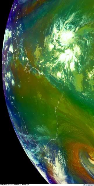
This image is a few hours old, but it shows that this is a HUGE system:

by the way, it's good to see everyone back again! I live a few feet away from the Gulf of Mexico, so I'll be around to provide pictures of any tropical system-oil spill horrors that might await us on the north central Gulf Coast!
by the way, it's good to see everyone back again! I live a few feet away from the Gulf of Mexico, so I'll be around to provide pictures of any tropical system-oil spill horrors that might await us on the north central Gulf Coast!
Last edited by rockyman on Sat Jun 12, 2010 9:50 pm, edited 1 time in total.
0 likes


-
SFLcane

- S2K Supporter
- Posts: 10281
- Age: 48
- Joined: Sat Jun 05, 2010 1:44 pm
- Location: Lake Worth Florida
Re: ATL : INVEST 92L
Here you can get a good crasp how large this wave is on this 4km IR loop. 4hr loop
http://raleighwx.easternuswx.com/models/satellite/ETropical4kmIR.html
http://raleighwx.easternuswx.com/models/satellite/ETropical4kmIR.html
0 likes
-
alan1961

- Category 2

- Posts: 771
- Joined: Mon Mar 20, 2006 11:58 am
- Location: Derby, Derbyshire, England
- Contact:
Re: ATL : INVEST 92L
cycloneye wrote:I am going to say that after seeing the last few hours of images,at the 2 AM TWO,they will increase the % to 50 and the color will be orange. What do the peeps think?
Alex(ander) the great by tomorrow
0 likes
-
HurricaneJoe22
- Category 1

- Posts: 456
- Joined: Wed Sep 08, 2004 12:45 am
- Location: Temple, Texas
Re: ATL : INVEST 92L
I think given where the storm is and the time of year, the NHC will stay conservative and keep it a yellow tonight and maybe bump up the percentage to 30. I think maybe after visibles in the morning and if it maintains convection and shows more organization, then a good chance at a bump to code orange. I'm not gonna get too excited over this one, but I'm glad it's looking interesting to break the boredom.
0 likes

Re: ATL : INVEST 92L
SFLcane wrote:Here you can get a good crasp how large this wave is on this 4km IR loop. 4hr loop
http://raleighwx.easternuswx.com/models/satellite/ETropical4kmIR.html
God that things a monster! I think there's little doubt this will be Alex given the model support, very good upper level conditions the next 72 hrs, warm SSTs, and the sheer size of this system.
0 likes
-
canetracker

- S2K Supporter
- Posts: 751
- Age: 63
- Joined: Wed Jul 27, 2005 8:49 pm
- Location: Suburbia New Orleans...Harahan, LA
Re: ATL : INVEST 92L
alan1961 wrote:cycloneye wrote:I am going to say that after seeing the last few hours of images,at the 2 AM TWO,they will increase the % to 50 and the color will be orange. What do the peeps think?
Alex(ander) the great by tomorrow
I am thinking code orange too.
0 likes
-
wxman57

- Moderator-Pro Met

- Posts: 23175
- Age: 68
- Joined: Sat Jun 21, 2003 8:06 pm
- Location: Houston, TX (southwest)
Re: ATL : INVEST 92L
All I can see for now is a little mid-level rotation. I don't think there's any LLC. That could come if thunderstorms persist over the same area tonight and tomorrow. T-numbers would be not be of much value at this point. Well, time for bed.
0 likes
-
canetracker
- S2K Supporter
- Posts: 751
- Age: 63
- Joined: Wed Jul 27, 2005 8:49 pm
- Location: Suburbia New Orleans...Harahan, LA
Re: ATL : INVEST 92L
wxman57 wrote:All I can see for now is a little mid-level rotation. I don't think there's any LLC. That could come if thunderstorms persist over the same area tonight and tomorrow. T-numbers would be not be of much value at this point. Well, time for bed.
Thanks for the educated input. : ) Love reading your posts.
0 likes
-
cycloneye

- Admin

- Posts: 149508
- Age: 69
- Joined: Thu Oct 10, 2002 10:54 am
- Location: San Juan, Puerto Rico
Re: ATL : INVEST 92L
Here is the 00z surface analysis from TAFB. Has the low moving WNW and pressure going down from the 1012 mbs.

0 likes
Visit the Caribbean-Central America Weather Thread where you can find at first post web cams,radars
and observations from Caribbean basin members Click Here
and observations from Caribbean basin members Click Here
-
hockeytim19

- Tropical Low

- Posts: 15
- Age: 45
- Joined: Mon Jun 07, 2010 7:36 pm
- Location: Deerfield Beach, FL
- Contact:
Re: ATL : INVEST 92L
An interesting note: At 7.2 N, Isadore in 1990 formed at the lowest-latitude for any storm in the North Atlantic. 92L could make a run at that record

0 likes
-
hockeytim19
- Tropical Low
- Posts: 15
- Age: 45
- Joined: Mon Jun 07, 2010 7:36 pm
- Location: Deerfield Beach, FL
- Contact:
Re: ATL : INVEST 92L
...and the amazing thing is that Isadore formed in September... not the first half of JUNE! 
hockeytim19 wrote:An interesting note: At 7.2 N, Isadore in 1990 formed at the lowest-latitude for any storm in the North Atlantic. 92L could make a run at that record
0 likes
-
cycloneye
- Admin
- Posts: 149508
- Age: 69
- Joined: Thu Oct 10, 2002 10:54 am
- Location: San Juan, Puerto Rico
Re: ATL : INVEST 92L
Nice loop.

0 likes
Visit the Caribbean-Central America Weather Thread where you can find at first post web cams,radars
and observations from Caribbean basin members Click Here
and observations from Caribbean basin members Click Here

-
frederic79

- Category 1
- Posts: 271
- Joined: Sun Jul 18, 2004 8:48 pm
- Location: Grand Bay, AL
Re: ATL : INVEST 92L
If this system is indicative of what's to come, then climotology doesn't mean alot this year. Does anyone know when the last time a Cape Verde system showed up in June, much less early June? This is always home-grown month or less. Wow, it feels like August both literally and figuratively!
0 likes
-
curtadams
- S2K Supporter
- Posts: 1122
- Joined: Sun Aug 28, 2005 7:57 pm
- Location: Orange, California
- Contact:
Re: ATL : INVEST 92L
I'm actually pretty bearish on this system. Big systems develop s - l - o - w - l - y. Low latitude will probably slow it more. Finally, without quickscat or recon, and with dim long-term prospects due to shear ahead, the NHC is really going to drag its feet about naming anything that does show up.
0 likes
Who is online
Users browsing this forum: No registered users and 23 guests