ATL : INVEST 92L - DISCUSSION
Moderator: S2k Moderators


There is still some convection near the center Cycloneye, the problem is the way the convection imploded further north is a sign of what sort of conditions 92l itself will be in within the next 24hrs.
0 likes
Personal Forecast Disclaimer:
The posts in this forum are NOT official forecast and should not be used as such. They are just the opinion of the poster and may or may not be backed by sound meteorological data. They are NOT endorsed by any professional institution or storm2k.org. For official information, please refer to the NHC and NWS products
The posts in this forum are NOT official forecast and should not be used as such. They are just the opinion of the poster and may or may not be backed by sound meteorological data. They are NOT endorsed by any professional institution or storm2k.org. For official information, please refer to the NHC and NWS products

Re: ATL : INVEST 92L - Discussion
I agree, convection to the north- east is dying and is increasing near the center
0 likes

-
HURAKAN

- Professional-Met

- Posts: 46084
- Age: 39
- Joined: Thu May 20, 2004 4:34 pm
- Location: Key West, FL
- Contact:
MEDIUM at 40%
TROPICAL WEATHER OUTLOOK
NWS TPC/NATIONAL HURRICANE CENTER MIAMI FL
800 PM EDT MON JUN 14 2010
FOR THE NORTH ATLANTIC...CARIBBEAN SEA AND THE GULF OF MEXICO...
AN AREA OF LOW PRESSURE LOCATED ABOUT 1250 MILES EAST OF THE LESSER
ANTILLES HAS CHANGED LITTLE TODAY...BUT CONTINUES TO SHOW SIGNS OF
ORGANIZATION. ENVIRONMENTAL CONDITIONS ARE FORECAST TO REMAIN
SOMEWHAT CONDUCIVE FOR DEVELOPMENT OF THIS LOW FOR THE NEXT DAY OR
SO...BUT ARE EXPECTED TO BECOME LESS FAVORABLE AFTER THAT. THERE
REMAINS A MEDIUM CHANCE...40 PERCENT...OF THIS SYSTEM BECOMING A
TROPICAL CYCLONE DURING THE NEXT 48 HOURS AS IT MOVES
WEST-NORTHWESTWARD TO NORTHWESTWARD AT ABOUT 15 MPH.
ELSEWHERE...TROPICAL CYCLONE FORMATION IS NOT EXPECTED DURING THE
NEXT 48 HOURS.
$$
FORECASTER STEWART/BLAKE
0 likes
-
Ivanhater

- Storm2k Moderator

- Posts: 11221
- Age: 39
- Joined: Fri Jul 01, 2005 8:25 am
- Location: Pensacola
Re: ATL : INVEST 92L - Discussion
Now that is an interesting TWO. HMMM tonight should be interesting
0 likes
Michael

Re: ATL : INVEST 92L - Discussion
I agree with the NHC we cannot rule out development yet, even if it looks less organized than earlier today, we could have a surprise tomorrow.
0 likes
-
Ivanhater
- Storm2k Moderator
- Posts: 11221
- Age: 39
- Joined: Fri Jul 01, 2005 8:25 am
- Location: Pensacola
Re: ATL : INVEST 92L - Discussion
.BUT CONTINUES TO SHOW SIGNS OF
ORGANIZATION.
Structurally it has, let's see if it can blow some storms up tonight
ORGANIZATION.
Structurally it has, let's see if it can blow some storms up tonight
0 likes
Michael
-
Ivanhater
- Storm2k Moderator
- Posts: 11221
- Age: 39
- Joined: Fri Jul 01, 2005 8:25 am
- Location: Pensacola
Re: ATL : INVEST 92L - Discussion
Looking at microwave imagery, it's obvious why the NHC says it has organized today...LLC is well defined...all it needs is to develop storms over the center, looking out for that tonight

0 likes
Michael
Its going to get one more shot, the shear over the center isn't too bad right now but is clearly really hammering off to the north, so much so you can see that convection has a really sheared look...
But the center LLC is still under less then 10kts...my interest has risen just a touch again.
But the center LLC is still under less then 10kts...my interest has risen just a touch again.
0 likes
Personal Forecast Disclaimer:
The posts in this forum are NOT official forecast and should not be used as such. They are just the opinion of the poster and may or may not be backed by sound meteorological data. They are NOT endorsed by any professional institution or storm2k.org. For official information, please refer to the NHC and NWS products
The posts in this forum are NOT official forecast and should not be used as such. They are just the opinion of the poster and may or may not be backed by sound meteorological data. They are NOT endorsed by any professional institution or storm2k.org. For official information, please refer to the NHC and NWS products

-
curtadams
- S2K Supporter

- Posts: 1122
- Joined: Sun Aug 28, 2005 7:57 pm
- Location: Orange, California
- Contact:
I agree it looks pretty nice on the IR2 loop, which is to say at lower cloud levels. But, the NHC likes persistence for numbering/naming - they hate numbering a system which is immediately going to evaporate, barring land threats. If it throws up some convection tonight, you could make an argument it's a TD, but I don't see the NHC numbering it unless they expect it to last at least a day and that seems unlikely with the shear/dry air issues we're all seeing.
0 likes
-
cycloneye

- Admin

- Posts: 149514
- Age: 69
- Joined: Thu Oct 10, 2002 10:54 am
- Location: San Juan, Puerto Rico
Re: ATL : INVEST 92L - Discussion
SSD Dvorak stays at 1.0.
14/2345 UTC 11.3N 41.7W T1.0/1.0 92L -- Atlantic
http://www.ssd.noaa.gov/PS/TROP/tdpositions.html
14/2345 UTC 11.3N 41.7W T1.0/1.0 92L -- Atlantic
http://www.ssd.noaa.gov/PS/TROP/tdpositions.html
0 likes
Visit the Caribbean-Central America Weather Thread where you can find at first post web cams,radars
and observations from Caribbean basin members Click Here
and observations from Caribbean basin members Click Here

Re: ATL : INVEST 92L - Discussion
I think at least one more night that it has a chance to produce and maintain some deeper convection, what appears to be a small LLC is pulling away from the convection to its northeast that was disrupting its inflow from the east quadrant.
zoomed in sat pic & where I think a small LLC is located:
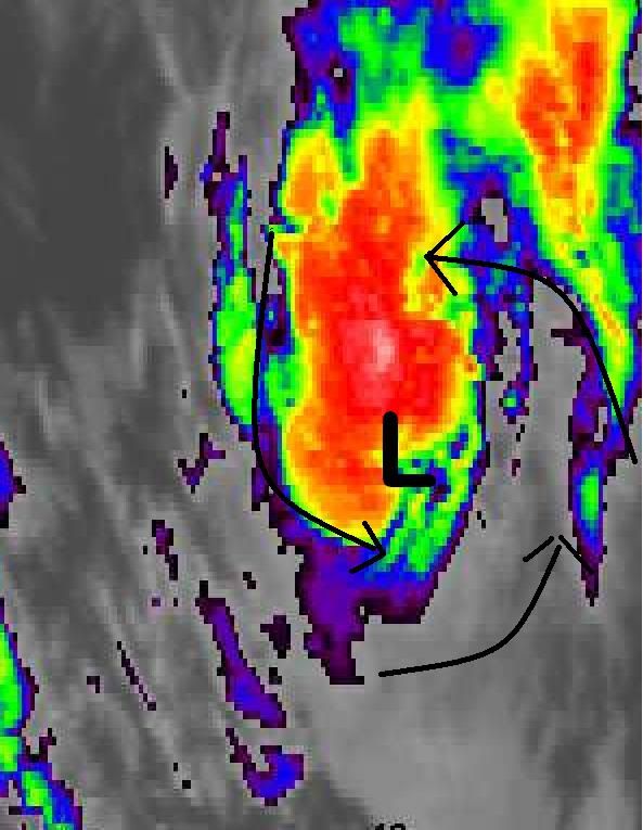
zoomed in sat pic & where I think a small LLC is located:
0 likes
-
cycloneye
- Admin
- Posts: 149514
- Age: 69
- Joined: Thu Oct 10, 2002 10:54 am
- Location: San Juan, Puerto Rico
Re: ATL : INVEST 92L - Discussion
00 UTC Best Track
AL, 92, 2010061500, , BEST, 0, 112N, 421W, 25, 1011, DB
AL, 92, 2010061500, , BEST, 0, 112N, 421W, 25, 1011, DB
0 likes
Visit the Caribbean-Central America Weather Thread where you can find at first post web cams,radars
and observations from Caribbean basin members Click Here
and observations from Caribbean basin members Click Here
-
Weatherfreak000
Re: ATL : INVEST 92L - Discussion
Convection has definitely finally made it over the center with that best track...as I can tell some nice healthy convection is fully incasing our center. If ever anything were to happen..it'd be happening tonight.
0 likes
-
lonelymike
- S2K Supporter
- Posts: 634
- Joined: Sat Jul 26, 2008 10:12 am
- Location: walton county fla
Re: ATL : INVEST 92L - Discussion
Don't worry the fat lady is warming up, Bones is on call and wxman57 will be along tomorrow to shatter another hurricane fantasy of many a young and promising youth 
Ivanhater: The work goes on and the dream never dies
Ivanhater: The work goes on and the dream never dies
0 likes
GO SEMINOLES

It looks decent enough right now, amazing what the sunset can sometimes do to these developing tropical systems...
Lets see how long it can hold its convection for before uncle shear comes knocking...
Lets see how long it can hold its convection for before uncle shear comes knocking...
0 likes
Personal Forecast Disclaimer:
The posts in this forum are NOT official forecast and should not be used as such. They are just the opinion of the poster and may or may not be backed by sound meteorological data. They are NOT endorsed by any professional institution or storm2k.org. For official information, please refer to the NHC and NWS products
The posts in this forum are NOT official forecast and should not be used as such. They are just the opinion of the poster and may or may not be backed by sound meteorological data. They are NOT endorsed by any professional institution or storm2k.org. For official information, please refer to the NHC and NWS products
It looks like a tropical storm, I'm sure if you showed many of the Joe Public out there it was a TS, they'd think your telling the truth with that image!
Does look like its going to have one more attempt before the shear kicks the living daylights out of it!
Does look like its going to have one more attempt before the shear kicks the living daylights out of it!
0 likes
Personal Forecast Disclaimer:
The posts in this forum are NOT official forecast and should not be used as such. They are just the opinion of the poster and may or may not be backed by sound meteorological data. They are NOT endorsed by any professional institution or storm2k.org. For official information, please refer to the NHC and NWS products
The posts in this forum are NOT official forecast and should not be used as such. They are just the opinion of the poster and may or may not be backed by sound meteorological data. They are NOT endorsed by any professional institution or storm2k.org. For official information, please refer to the NHC and NWS products
Who is online
Users browsing this forum: No registered users and 15 guests