
ATL : INVEST 92L - DISCUSSION
Moderator: S2k Moderators
-
ozonepete
- Professional-Met

- Posts: 4743
- Joined: Mon Sep 07, 2009 3:23 pm
- Location: From Ozone Park, NYC / Now in Brooklyn, NY
Re: ATL : INVEST 92L - Discussion
I wonder if the shear is lessening because an upper level low is developing ahead of it within the TUTT. If you watch the motion in the upper level clouds, it seems like this is a possibility...
0 likes

Re: Re:
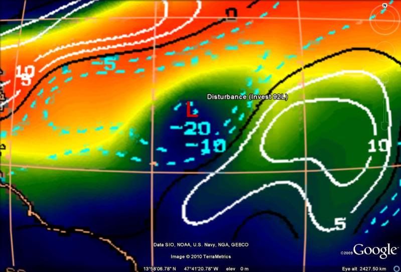
HURAKAN wrote:bvigal wrote:Hey Hurakan, am I reading that shear map wrong? I was looking at the same thing, and 92 looks to me close to 30kt, then 40kt in a few hrs. Here, I've marked it on the pic you posted:
Good observation. I missed that!

But the shear streak has been moving NW as well, but not as fast as 92L has been moving, so I would think that by tomorrow some time it will reach the stronger shear of 30-40 knots.
0 likes
-
cycloneye

- Admin

- Posts: 149508
- Age: 69
- Joined: Thu Oct 10, 2002 10:54 am
- Location: San Juan, Puerto Rico
Re: ATL : INVEST 92L - Discussion
The latest image at 0245z.-80C tops return.

0 likes
Visit the Caribbean-Central America Weather Thread where you can find at first post web cams,radars
and observations from Caribbean basin members Click Here
and observations from Caribbean basin members Click Here
-
Ivanhater

- Storm2k Moderator

- Posts: 11221
- Age: 39
- Joined: Fri Jul 01, 2005 8:25 am
- Location: Pensacola
Re: ATL : INVEST 92L - Discussion
I will say this, I would not want to be caught under this thunderstorm complex

0 likes
Michael
-
Fego

- S2K Supporter

- Posts: 767
- Age: 66
- Joined: Sun Apr 18, 2004 7:58 pm
- Location: San Juan, Puerto Rico
- Contact:

-
bvigal

- S2K Supporter
- Posts: 2276
- Joined: Sun Jul 24, 2005 8:49 am
- Location: British Virgin Islands
- Contact:
Re: ATL : INVEST 92L - Discussion
Interesting idea about an upper level low. I've been looking at the various level vorticity since mid-afternoon, stacked on 92L with those tops. We've had this upper level trough over us for days - see here
I think shear often doesn't result as forecast when tropical lows are involved, it seems much more predictable in winter. If shear does kill it short term, which looks likely, when it gets here that energy will make for some good gusty tstorms, etc. However, as it moves further west, you guys on the mainland keep an eye on this... I never discount a disturbance that has unusual staying power, it might lose its organization and impressive appearance on satellite, but the energy is still there.
I think shear often doesn't result as forecast when tropical lows are involved, it seems much more predictable in winter. If shear does kill it short term, which looks likely, when it gets here that energy will make for some good gusty tstorms, etc. However, as it moves further west, you guys on the mainland keep an eye on this... I never discount a disturbance that has unusual staying power, it might lose its organization and impressive appearance on satellite, but the energy is still there.
0 likes
-
cycloneye
- Admin
- Posts: 149508
- Age: 69
- Joined: Thu Oct 10, 2002 10:54 am
- Location: San Juan, Puerto Rico
Re: ATL : INVEST 92L - Discussion
bvigal wrote:Interesting idea about an upper level low. I've been looking at the various level vorticity since mid-afternoon, stacked on 92L with those tops. We've had this upper level trough over us for days - see here
I think shear often doesn't result as forecast when tropical lows are involved, it seems much more predictable in winter. If shear does kill it short term, which looks likely, when it gets here that energy will make for some good gusty tstorms, etc. However, as it moves further west, you guys on the mainland keep an eye on this... I never discount a disturbance that has unusual staying power, it might lose its organization and impressive appearance on satellite, but the energy is still there.
Regardless of what kind of system may be,it will bring some squally weather this fathers day weekend to the NE Caribbean.
0 likes
Visit the Caribbean-Central America Weather Thread where you can find at first post web cams,radars
and observations from Caribbean basin members Click Here
and observations from Caribbean basin members Click Here

-
bvigal
- S2K Supporter
- Posts: 2276
- Joined: Sun Jul 24, 2005 8:49 am
- Location: British Virgin Islands
- Contact:
Re: ATL : INVEST 92L - Discussion
Yes, Luis!!
Hey, look at the size of that convection over 3 hrs, compared to the size of Puerto Rico - quite impressive!


Hey, look at the size of that convection over 3 hrs, compared to the size of Puerto Rico - quite impressive!
0 likes
-
vbhoutex

- Storm2k Executive
- Posts: 29149
- Age: 74
- Joined: Wed Oct 09, 2002 11:31 pm
- Location: Cypress, TX
- Contact:
Re: ATL : INVEST 92L - Discussion
You can bet we will. We've seen them go to almost nothing and then HELLO here I am again. NEVER SAY NEVER in the tropics, especially with conditions the way they are this season.bvigal wrote:Interesting idea about an upper level low. I've been looking at the various level vorticity since mid-afternoon, stacked on 92L with those tops. We've had this upper level trough over us for days - see here
I think shear often doesn't result as forecast when tropical lows are involved, it seems much more predictable in winter. If shear does kill it short term, which looks likely, when it gets here that energy will make for some good gusty tstorms, etc. However, as it moves further west, you guys on the mainland keep an eye on this... I never discount a disturbance that has unusual staying power, it might lose its organization and impressive appearance on satellite, but the energy is still there.
0 likes
Skywarn, C.E.R.T.
Please click below to donate to STORM2K to help with the expenses of keeping the site going:

Please click below to donate to STORM2K to help with the expenses of keeping the site going:

-
hockeytim19

- Tropical Low

- Posts: 15
- Age: 45
- Joined: Mon Jun 07, 2010 7:36 pm
- Location: Deerfield Beach, FL
- Contact:
Re: ATL : INVEST 92L - Discussion
I think for the past few hours, 92L has had the perfect amount of shear to help ventilate itself, allowing for some storms to blow up right around the center... but very soon, it will encounter very high shear values (30-40+ kts) and that will effectively shut off this temporary upward pulse of convectionand turn 92L into a naked swirl.
0 likes
Re: ATL : INVEST 92L - Discussion
Shear continues to move out of the way, at least for now and 92L is not in such a bad position.
0 likes
-
HURAKAN

- Professional-Met
- Posts: 46084
- Age: 39
- Joined: Thu May 20, 2004 4:34 pm
- Location: Key West, FL
- Contact:
LOW - 10%
996
ABNT20 KNHC 160525
TWOAT
TROPICAL WEATHER OUTLOOK
NWS TPC/NATIONAL HURRICANE CENTER MIAMI FL
200 AM EDT WED JUN 16 2010
FOR THE NORTH ATLANTIC...CARIBBEAN SEA AND THE GULF OF MEXICO...
ALTHOUGH SHOWER AND THUNDERSTORM ACTIVITY ASSOCIATED WITH THE LOW
PRESSURE SYSTEM LOCATED ABOUT 850 MILES EAST OF THE LESSER ANTILLES
HAS INCREASED TONIGHT...UPPER-LEVEL WINDS ARE UNFAVORABLE FOR
TROPICAL CYCLONE FORMATION. THERE IS A LOW CHANCE...10 PERCENT...OF
THIS SYSTEM BECOMING A TROPICAL CYCLONE DURING THE NEXT 48 HOURS AS
IT MOVES WEST-NORTHWESTWARD TO NORTHWESTWARD NEAR 15 MPH.
ELSEWHERE...TROPICAL CYCLONE FORMATION IS NOT EXPECTED DURING THE
NEXT 48 HOURS.
$$
FORECASTER CANGIALOSI/BEVEN
0 likes
-
Brent
- S2K Supporter
- Posts: 38755
- Age: 37
- Joined: Sun May 16, 2004 10:30 pm
- Location: Tulsa Oklahoma
- Contact:
Re: ATL : INVEST 92L - Discussion
NHC says NEXT, everyone go to bed 
I am intrigued tonight but I will wait til morning to see how it looks. My thinking is it will poof again just like the past 2 days.
I am intrigued tonight but I will wait til morning to see how it looks. My thinking is it will poof again just like the past 2 days.
0 likes
#neversummer


Re: ATL : INVEST 92L - Discussion
I am impressed....didnt see this latest flare-up coming. This is a TD in my book...if the convection persists NHC will have to upgrade. Then again if it runs into 30knts of shear then its decapitation ala Chris back in 06.....
edit to add.....Hey Brent nice to see you still around...
edit to add.....Hey Brent nice to see you still around...
0 likes

-
Brent
- S2K Supporter
- Posts: 38755
- Age: 37
- Joined: Sun May 16, 2004 10:30 pm
- Location: Tulsa Oklahoma
- Contact:
Re: ATL : INVEST 92L - Discussion
ROCK wrote:I am impressed....didnt see this latest flare-up coming. This is a TD in my book...if the convection persists NHC will have to upgrade. Then again if it runs into 30knts of shear then its decapitation ala Chris back in 06.....
edit to add.....Hey Brent nice to see you still around...
HAHA, I'll be around more once we get storms. Not these sorry invests that can't make up their mind.
0 likes
#neversummer

Who is online
Users browsing this forum: No registered users and 60 guests