ATL : INVEST 92L - DISCUSSION
Moderator: S2k Moderators
-
djones65
- Category 1

- Posts: 264
- Age: 60
- Joined: Mon Jun 20, 2005 12:05 am
- Location: Ocean Springs, MS
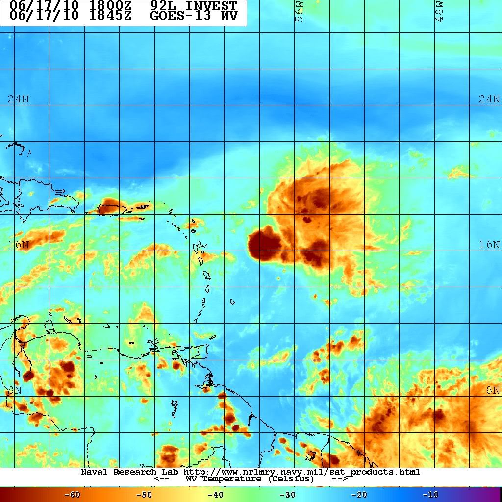
A ship at 17.8N and 58.6W at 1800 UTC reported east winds (90 degrees) at 24.1 knots and seas of 13.1 feet. It is located 120 miles north of the vorticity maximum. A second ship also unidentified near 15.4N and 61.5W at 1800 UTC reported NNE winds (30 degrees) at 19 knots. This ship was located 190 miles west southwest of the vorticity maximum. Both ships reported 1015 mb pressures, but ambient pressure to the north is rather high at 1019 mb. Lastly, a buoy, I believe 41101, located near 14.6N and 56.2W had the sharp wave/low level vortmax pass very near it early this morning. As it passed pressure dropped to at least 1012 mb (we didn't get consistent observations as it passed), and at 1100UTC the winds were out of the south (180 degrees) at 7 knots. Obviously these obs do not confirm a surface circulation, but I don't think it rules out one either. Convection continues to blossom just to the east of the low level vortmax and I believe I can see it on the western edge of the latest burst of convection. If you look at water vapor loops there appears to be two upper level circulations forming within the TUTT lying across the Greater Antilles with the most significant being near 22N and 64W roughly. If this feature becomes more pronounced it will "pull" the strongest westerly winds north and westward allowing more ridging to develop over 92L. The upper low is moving westward. If it moves more southwestward it can help create a ridge over the northeastern Caribbean Sea. There are so many ifs obviously the potential for development into a tropical cyclone is very low, but I am glad to see NHC discussing it once again in their outlooks.
0 likes
-
Nederlander
- S2K Supporter

- Posts: 1259
- Joined: Sat Jul 19, 2008 4:28 pm
- Location: Conroe, TX
Re: ATL : INVEST 92L - DISCUSSION
will 92L be passing by any buoys in the near future?? would love to see some data on how this system is being able to handle all of this shear..
0 likes
-
srainhoutx

- S2K Supporter
- Posts: 6919
- Age: 68
- Joined: Sun Jan 14, 2007 11:34 am
- Location: Haywood County, NC
- Contact:
Re: ATL : INVEST 92L - DISCUSSION
0 likes
Carla/Alicia/Jerry(In The Eye)/Michelle/Charley/Ivan/Dennis/Katrina/Rita/Wilma/Ike/Harvey
Member: National Weather Association
Wx Infinity Forums
http://wxinfinity.com/index.php
Facebook.com/WeatherInfinity
Twitter @WeatherInfinity
Member: National Weather Association
Wx Infinity Forums
http://wxinfinity.com/index.php
Facebook.com/WeatherInfinity
Twitter @WeatherInfinity
-
tolakram
- Admin

- Posts: 20186
- Age: 62
- Joined: Sun Aug 27, 2006 8:23 pm
- Location: Florence, KY (name is Mark)
Re: ATL : INVEST 92L - DISCUSSION
Nederlander wrote:will 92L be passing by any buoys in the near future?? would love to see some data on how this system is being able to handle all of this shear..
edit:
I was seeing something but clearly misreading the map.
Last edited by tolakram on Thu Jun 17, 2010 2:08 pm, edited 1 time in total.
0 likes
M a r k
- - - - -
Join us in chat: Storm2K Chatroom Invite. Android and IOS apps also available.
The posts in this forum are NOT official forecasts and should not be used as such. Posts are NOT endorsed by any professional institution or STORM2K.org. For official information and forecasts, please refer to NHC and NWS products.
-
cycloneye

- Admin
- Posts: 149505
- Age: 69
- Joined: Thu Oct 10, 2002 10:54 am
- Location: San Juan, Puerto Rico
Re: ATL : INVEST 92L - DISCUSSION
92L is back at our authomated graphic above.

0 likes
Visit the Caribbean-Central America Weather Thread where you can find at first post web cams,radars
and observations from Caribbean basin members Click Here
and observations from Caribbean basin members Click Here
-
lrak

- S2K Supporter
- Posts: 1770
- Age: 59
- Joined: Thu Jun 21, 2007 2:48 pm
- Location: Corpus Christi, TX
Re: ATL : INVEST 92L - DISCUSSION
That blob of new convection blew up right over the leftover circulation...hmmm.
lrak AKA karl
lrak AKA karl
0 likes
AKA karl
Also
Personal Forecast Disclaimer:
My posts on this forum are NOT official forecast and should not be used as such. My posts are my basic observations and are definitely not backed by any "well some" meteorological knowledge. For official information, please refer to the NHC and NWS products.
Also
Personal Forecast Disclaimer:
My posts on this forum are NOT official forecast and should not be used as such. My posts are my basic observations and are definitely not backed by any "well some" meteorological knowledge. For official information, please refer to the NHC and NWS products.
-
Fego

- S2K Supporter
- Posts: 767
- Age: 66
- Joined: Sun Apr 18, 2004 7:58 pm
- Location: San Juan, Puerto Rico
- Contact:
Re: ATL : INVEST 92L - DISCUSSION
"..still standing".. like the Billy Joel song. Open wave or not, look like it will be a raining weekend .

Uploaded with ImageShack.us

Uploaded with ImageShack.us
0 likes
Go Giants! Go Niners! Go Warriors!
-
djones65
- Category 1
- Posts: 264
- Age: 60
- Joined: Mon Jun 20, 2005 12:05 am
- Location: Ocean Springs, MS
Observations from Guadeloupe and all of the Lesser Antilles will be very interesting tonight. The potential for heavy rains is very significant for the islands of the northeast Caribbean and farther west over the weekend so I hope we don't see any problems from that. And as usual, even if this was a named tropical system, that would likely be the greatest threat anyway. But we should be able to get good surface observations now that 92L is approaching the islands, and if a closed surface circulation is observed I imagine NHC will have a dilemma of what to do...
0 likes


-
Gustywind

- Category 5

- Posts: 12334
- Joined: Mon Sep 03, 2007 7:29 am
- Location: Baie-Mahault, GUADELOUPE
Re:
djones65 wrote:Observations from Guadeloupe and all of the Lesser Antilles will be very interesting tonight. The potential for heavy rains is very significant for the islands of the northeast Caribbean and farther west over the weekend so I hope we don't see any problems from that. And as usual, even if this was a named tropical system, that would likely be the greatest threat anyway. But we should be able to get good surface observations now that 92L is approaching the islands, and if a closed surface circulation is observed I imagine NHC will have a dilemma of what to do...
Absolutely my friend, if anything happens tonight and tommorow i will try to keep you informed as usual and as possible. Hope that ours friends from Guadeloupe and the adjacents islands of the carib will post some news too...
Gustywind
0 likes
-
MGC

- S2K Supporter
- Posts: 5940
- Joined: Sun Mar 23, 2003 9:05 pm
- Location: Pass Christian MS, or what is left.
Re: ATL : INVEST 92L - DISCUSSION
92L keeps hanging on. Gotta keep an eye on it until it completely falls apart. I'm afraid that if the shear relaxes to any degree it might organize quickly......MGC
0 likes
-
Brent
- S2K Supporter
- Posts: 38755
- Age: 37
- Joined: Sun May 16, 2004 10:30 pm
- Location: Tulsa Oklahoma
- Contact:
Re: ATL : INVEST 92L - DISCUSSION
The fact it looks decent in the face of 30-40 kts of shear tells me there's something to closely watch here. It may not ever develop, but I don't think it's dead either. It will have a much better environment to develop in 2-3 days.
0 likes
#neversummer
Re: ATL : INVEST 92L - DISCUSSION
MGC wrote:92L keeps hanging on. Gotta keep an eye on it until it completely falls apart. I'm afraid that if the shear relaxes to any degree it might organize quickly......MGC
Indeed, SHIPS, assuming a low persisting through the forecast period starts to strengthen it after 96 hours or so, as the shear forecast by GFS drops under 20 knots. It also assumes the BAMM forecast track, which has the low clipping the southern coast of Hispanola.
Code: Select all
*   ATLANTIC SHIPS INTENSITY FORECAST       *
                    *      GOES DATA AVAILABLE                  *
                    *      OHC  DATA AVAILABLE                  *
                    *  INVEST      AL922010  06/17/10  18 UTC   *

TIME (HR)          0     6    12    18    24    36    48    60    72    84    96   108   120
V (KT) NO LAND    25    24    23    22    22    22    24    25    26    28    35    42    49
V (KT) LAND       25    24    23    22    22    22    24    25    26    25    30    37    44
V (KT) LGE mod    25    25    24    23    22    21    20    20    21    23    26    32    35

SHEAR (KT)        36    36    31    29    24    27    24    25    14    21    20    18    19
0 likes
-
pepeavilenho
- Tropical Storm

- Posts: 171
- Joined: Thu Jul 09, 2009 12:01 pm

-
cycloneye
- Admin
- Posts: 149505
- Age: 69
- Joined: Thu Oct 10, 2002 10:54 am
- Location: San Juan, Puerto Rico
Re: ATL : INVEST 92L - DISCUSSION
What it will do is bring plenty of squally weather to the NE Caribbean this weekend.More about local effects at the big Caribbean thread at U.S & Caribbean forum.
viewtopic.php?f=24&t=85676&p=1992304#p1992304
viewtopic.php?f=24&t=85676&p=1992304#p1992304
0 likes
Visit the Caribbean-Central America Weather Thread where you can find at first post web cams,radars
and observations from Caribbean basin members Click Here
and observations from Caribbean basin members Click Here
-
Ivanhater

- Storm2k Moderator

- Posts: 11221
- Age: 39
- Joined: Fri Jul 01, 2005 8:25 am
- Location: Pensacola
Re: ATL : INVEST 92L - DISCUSSION
It's interesting to note that right now is the strongest shear this will face. Shear decreasing ahead as 92L moves west

0 likes
Michael


-
cycloneye
- Admin
- Posts: 149505
- Age: 69
- Joined: Thu Oct 10, 2002 10:54 am
- Location: San Juan, Puerto Rico
Re: ATL : INVEST 92L - DISCUSSION
Here is the synopsis from the San Juan NWS that talks about the TUTT.
AREA FORECAST DISCUSSION
NATIONAL WEATHER SERVICE SAN JUAN PR
401 PM AST THU JUN 17 2010
.SYNOPSIS...
A TUTT AND ASSOCIATED AREA OF LOW PRESSURE NOW EXTENDING ALMOST
EAST TO WEST ACROSS THE ATLANTIC...AND JUST NORTH OF PUERTO RICO
AND THE NORTHERN LEEWARDS...AND WILL SLOWLY LIFT NORTHWARDS OVER
THE NEXT DAY OR SO...AS HIGH PRESSURE BUILDS AND SPREADS NORTH
OVER THE LOCAL REGION.
0 likes
Visit the Caribbean-Central America Weather Thread where you can find at first post web cams,radars
and observations from Caribbean basin members Click Here
and observations from Caribbean basin members Click Here
Who is online
Users browsing this forum: No registered users and 71 guests