ATL : INVEST 92L - DISCUSSION
Moderator: S2k Moderators
-
gatorcane

- S2K Supporter

- Posts: 23708
- Age: 48
- Joined: Sun Mar 13, 2005 3:54 pm
- Location: Boca Raton, FL
Whether this develops or not, one things seems quite possible -- that this wave and associated moisture may be heading to Bahamas/Southern FL/FL Straits in the long-range. I've seen run after run of the GFS bringing the wave through South FL. That would be nice as here in Palm Beach (Eastern), it hasn't rained alot the past couple of weeks with strong ridging aloft so I would welcome something to create an increase in moisture.
0 likes
-
Evil Jeremy

- S2K Supporter
- Posts: 5463
- Age: 32
- Joined: Mon Apr 10, 2006 2:10 pm
- Location: Los Angeles, CA
Re: ATL : INVEST 92L - DISCUSSION
92L is hanging in there. However, it still has quite a bit of shear to go through. If it can maintain its current organization, which isn't much, it could have a chance in a few days.
0 likes
Frances 04 / Jeanne 04 / Katrina 05 / Wilma 05 / Fay 08 / Debby 12 / Andrea 13 / Colin 16 / Hermine 16 / Matthew 16 / Irma 17

Re: ATL : INVEST 92L - DISCUSSION
I'm gonna beat wxman57 to the punch. The convection has increased due to the shear but there is no sign of a closed circulation. check back in a day or so! 
Squally weather for the northern windwards.
Squally weather for the northern windwards.
0 likes
The following post is NOT an official forecast and should not be used as such. It is just the opinion of the poster and may or may not be backed by sound meteorological data. It is NOT endorsed by any professional institution including storm2k.org For Official Information please refer to the NHC and NWS products.

This system is certainly interesting, the fact the jet streak is lifting out slightly is certainly helping this one out.
I'd keep an eye on this one down the line, not sure it'll develop but its clearly an active wave still and there is more then a few hints that there is still a semi decent circulation, if it doess stumble into decent conditions it'll need watching closely, esp as it'll move into an area where history does support development.
I'd keep an eye on this one down the line, not sure it'll develop but its clearly an active wave still and there is more then a few hints that there is still a semi decent circulation, if it doess stumble into decent conditions it'll need watching closely, esp as it'll move into an area where history does support development.
0 likes
Personal Forecast Disclaimer:
The posts in this forum are NOT official forecast and should not be used as such. They are just the opinion of the poster and may or may not be backed by sound meteorological data. They are NOT endorsed by any professional institution or storm2k.org. For official information, please refer to the NHC and NWS products
The posts in this forum are NOT official forecast and should not be used as such. They are just the opinion of the poster and may or may not be backed by sound meteorological data. They are NOT endorsed by any professional institution or storm2k.org. For official information, please refer to the NHC and NWS products
-
Bocadude85

- Category 5

- Posts: 2991
- Age: 39
- Joined: Mon Apr 18, 2005 2:20 pm
- Location: Honolulu,Hi
Re: ATL : INVEST 92L - DISCUSSION
http://rammb.cira.colostate.edu/product ... 130800.GIF
Looks like the llc was pulled back into the convection.
Looks like the llc was pulled back into the convection.
0 likes
-
srainhoutx

- S2K Supporter
- Posts: 6919
- Age: 68
- Joined: Sun Jan 14, 2007 11:34 am
- Location: Haywood County, NC
- Contact:
Re: ATL : INVEST 92L - DISCUSSION
0 likes
Carla/Alicia/Jerry(In The Eye)/Michelle/Charley/Ivan/Dennis/Katrina/Rita/Wilma/Ike/Harvey
Member: National Weather Association
Wx Infinity Forums
http://wxinfinity.com/index.php
Facebook.com/WeatherInfinity
Twitter @WeatherInfinity
Member: National Weather Association
Wx Infinity Forums
http://wxinfinity.com/index.php
Facebook.com/WeatherInfinity
Twitter @WeatherInfinity
-
Explorer93
- Tropical Low

- Posts: 11
- Joined: Sun Jun 13, 2010 12:47 am
- Location: Pensacola, FL
Re: ATL : INVEST 92L - DISCUSSION
I'm surprised it even past the shear that was in front of it. The convection has really came together in the past 12 hours.
0 likes
-
wxman57

- Moderator-Pro Met

- Posts: 23175
- Age: 68
- Joined: Sat Jun 21, 2003 8:06 pm
- Location: Houston, TX (southwest)
Re: ATL : INVEST 92L - DISCUSSION
tailgater wrote:I'm gonna beat wxman57 to the punch. The convection has increased due to the shear but there is no sign of a closed circulation. check back in a day or so!
Squally weather for the northern windwards.
How'd you know I was just about to post?
Right, no LLC any longer, just a wave axis in high shear. And it won't remember that it used to have an LLC when it passes the shear zone. But it WILL be a moderate area of vorticity moving into a region of warm water and lower shear by late this weekend/early next week. Euro and Canadian split the vorticity in two, taking part toward the Yucatan and part north of Cuba into the SE Gulf by Wednesday. GFS moves the main vorticity north of Cuba thru the FL Straits and west of Key West by Wednesday.
If something does remain of the vorticity next Tue/Wed when it gets away from Cuba, then there is the potential for development. Wind shear in the south-central and SE Gulf won't be extremely high then, but a building ridge along the mid Gulf Coast may cause it to slow/stall next Wed/Thu and/or move slowly westward.
We have some very sensitive clients off the SE LA coast to worry about, so I'm keeping a close watch on it.

0 likes
Re: ATL : INVEST 92L - DISCUSSION
I think the odds are slim but it could refire after hitting favorable June climatology in the June formation areas.
If you made me bet I would say poof.
If you made me bet I would say poof.
0 likes
-
Ivanhater

- Storm2k Moderator

- Posts: 11221
- Age: 39
- Joined: Fri Jul 01, 2005 8:25 am
- Location: Pensacola
Re: ATL : INVEST 92L - DISCUSSION
I agree wxman. With each convective burst like this, it allows the vorticity that you mention to get stronger. Also if the worst of the shear stays just to the north like the gfs has been advertising, then we may have a player here down the road
0 likes
Michael

-
lrak

- S2K Supporter
- Posts: 1770
- Age: 59
- Joined: Thu Jun 21, 2007 2:48 pm
- Location: Corpus Christi, TX
Re: ATL : INVEST 92L - DISCUSSION
I sure hope it doesn't get too strong in the Gulf. This year suxors bad for wave wishing, I want the ocean to stay calm and glassy for a few years.
0 likes
AKA karl
Also
Personal Forecast Disclaimer:
My posts on this forum are NOT official forecast and should not be used as such. My posts are my basic observations and are definitely not backed by any "well some" meteorological knowledge. For official information, please refer to the NHC and NWS products.
Also
Personal Forecast Disclaimer:
My posts on this forum are NOT official forecast and should not be used as such. My posts are my basic observations and are definitely not backed by any "well some" meteorological knowledge. For official information, please refer to the NHC and NWS products.
-
cycloneye

- Admin

- Posts: 149508
- Age: 69
- Joined: Thu Oct 10, 2002 10:54 am
- Location: San Juan, Puerto Rico
Re: ATL : INVEST 92L - DISCUSSION
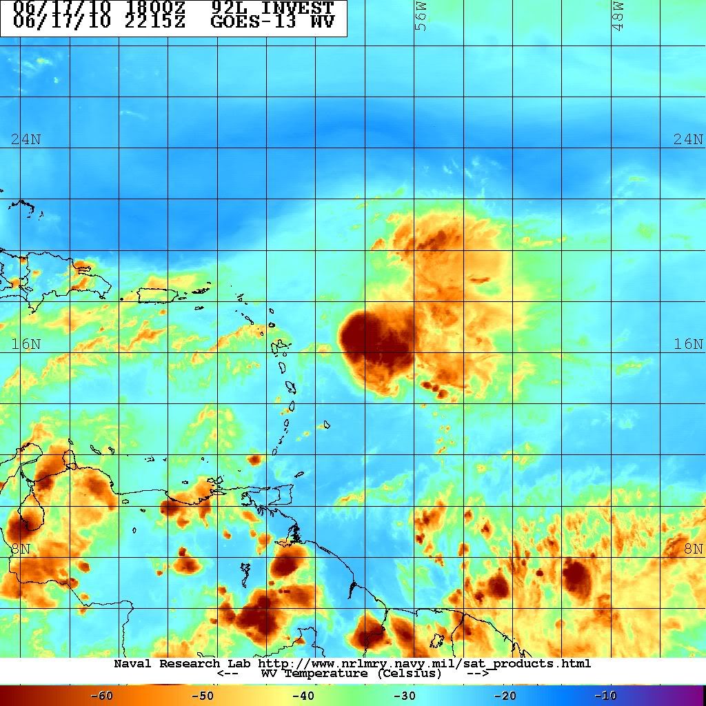
The latest at 23:15Z.

0 likes
Visit the Caribbean-Central America Weather Thread where you can find at first post web cams,radars
and observations from Caribbean basin members Click Here
and observations from Caribbean basin members Click Here
-
cycloneye
- Admin
- Posts: 149508
- Age: 69
- Joined: Thu Oct 10, 2002 10:54 am
- Location: San Juan, Puerto Rico
Re: ATL : INVEST 92L - DISCUSSION
Up to 20%
TROPICAL WEATHER OUTLOOK
NWS TPC/NATIONAL HURRICANE CENTER MIAMI FL
800 PM EDT THU JUN 17 2010
FOR THE NORTH ATLANTIC...CARIBBEAN SEA AND THE GULF OF MEXICO...
A STRONG TROPICAL WAVE APPROACHING THE LEEWARD ISLANDS IS PRODUCING
AN AREA OF SHOWERS AND THUNDERSTORMS. ALTHOUGH THE ASSOCIATED
SHOWER AND THUNDERSTORM ACTIVITY HAS INCREASED THIS EVENING...IT
REMAINS POORLY ORGANIZED DUE TO STRONG UPPER-LEVEL WINDS.
DEVELOPMENT...IF ANY...IS EXPECTED TO BE SLOW TO OCCUR AS THIS
SYSTEM MOVES WEST-NORTHWESTWARD AT ABOUT 15 MPH. THERE IS A LOW
CHANCE...20 PERCENT...OF THIS SYSTEM BECOMING A TROPICAL CYCLONE
DURING THE NEXT 48 HOURS. REGARDLESS OF DEVELOPMENT...LOCALLY
HEAVY RAINS AND GUSTY WINDS ARE POSSIBLE OVER PORTIONS OF THE
LEEWARD ISLANDS...THE VIRGIN ISLANDS...AND PUERTO RICO OVER THE
NEXT DAY OR TWO.
ELSEWHERE...TROPICAL CYCLONE FORMATION IS NOT EXPECTED DURING THE
NEXT 48 HOURS.
$$
FORECASTER CANGIALOSI/PASCH
0 likes
Visit the Caribbean-Central America Weather Thread where you can find at first post web cams,radars
and observations from Caribbean basin members Click Here
and observations from Caribbean basin members Click Here
-
cycloneye
- Admin
- Posts: 149508
- Age: 69
- Joined: Thu Oct 10, 2002 10:54 am
- Location: San Juan, Puerto Rico
Re: ATL : INVEST 92L - DISCUSSION
Ivanhater wrote:That is a big change
Because of this part right?
DEVELOPMENT...IF ANY...IS EXPECTED TO BE SLOW TO OCCUR AS THIS
SYSTEM MOVES WEST-NORTHWESTWARD AT ABOUT 15 MPH
0 likes
Visit the Caribbean-Central America Weather Thread where you can find at first post web cams,radars
and observations from Caribbean basin members Click Here
and observations from Caribbean basin members Click Here
-
Ivanhater
- Storm2k Moderator
- Posts: 11221
- Age: 39
- Joined: Fri Jul 01, 2005 8:25 am
- Location: Pensacola
Re: ATL : INVEST 92L - DISCUSSION
Storms continue to cool..really surprised the ball of convection has maintained for so long. Hot towers increasing of -80c

0 likes
Michael
Re: ATL : INVEST 92L - DISCUSSION
Ivanhater wrote:I agree wxman. With each convective burst like this, it allows the vorticity that you mention to get stronger. Also if the worst of the shear stays just to the north like the gfs has been advertising, then we may have a player here down the road
Yeah I'm starting to get increasingly curious about the possible set-up down the road. Its a long way off but if the jet can stay where it is and slightly move northwards then the ball of convection won't be sheared to pieces, at least not very often anyway...and if you can get it into the more favourable region down the road I'd be very worried, esp because its heading towards an area that certainly has been known to develop storms in the past.
0 likes
Personal Forecast Disclaimer:
The posts in this forum are NOT official forecast and should not be used as such. They are just the opinion of the poster and may or may not be backed by sound meteorological data. They are NOT endorsed by any professional institution or storm2k.org. For official information, please refer to the NHC and NWS products
The posts in this forum are NOT official forecast and should not be used as such. They are just the opinion of the poster and may or may not be backed by sound meteorological data. They are NOT endorsed by any professional institution or storm2k.org. For official information, please refer to the NHC and NWS products


-
djones65
- Category 1

- Posts: 264
- Age: 60
- Joined: Mon Jun 20, 2005 12:05 am
- Location: Ocean Springs, MS
Here is the link to the radar from Guadeloupe...
http://www.meteo.fr/temps/domtom/antill ... SAIC2.html
Click on animation if it isn't looping... Unfortunately there only appears to be four frames to animate, approximately one hour at 15 min intervals, but it is interesting nonetheless...
I still don't think we have enough observations to confirm that there is not a surface circulation with this vortmax and I think it is a possibility that a small vortex is under the western edge of the convection. With that being said my personal opinion is that the rotation seen in visible imagery is just above the surface, say at 850 mb or so. Also, earlier today the low level vortmax I was tracking was moving at almost 20 mph, and had been for the preceeding 30 hours or so. Since 1800 UTC when the small vortmax was located at 16N and 58.5W it should be at least near 60W by now. I see no reason why the low level vortmax would come to a sudden halt, yet the deep convection has not progressed west of 59W. Therefore, I imagine that shear is still strong as most of us has stated and the system is definitely not developing at this time in my opinion. At least not significantly... I still see the upper circulation within the TUTT north of Puerto Rico is still retrograding and the main shear jet is being pulled gradually northward and westward and a ridge is increasing over the SE Caribbean and 92L. The diffluence between the ridge/anticyclone near 10N 60W and the upper low near 22N 65W is enhancing thunderstorm development. If the upper low keeps moving westward I think it is possible the upper ridge can build northward over 92L in about 36 hours and provide a more favorable environment for strengthening very late in the weekend or early next week. Of course this is just my opinion and is not official information. I would expect that after midnight tonight or on Saturday we will have sufficient surface observations to confirm that this system is an open wave or still has a small surface circulation.
0 likes
Who is online
Users browsing this forum: No registered users and 66 guests