ATL : TROPICAL DEPRESSION ALEX - MODELS
Moderator: S2k Moderators

-
floridasun78
- Category 5

- Posts: 3755
- Joined: Sun May 17, 2009 10:16 pm
- Location: miami fl
-
x-y-no

- Category 5
- Posts: 8359
- Age: 65
- Joined: Wed Aug 11, 2004 12:14 pm
- Location: Fort Lauderdale, FL
Re:
floridasun78 wrote:what is chance of track moving more toward right?
I'd say not much at all in the short term (say the next three days.)
After that, it depends on how fast it develops and whether the mid-level weakness the Euro sees is there.
0 likes


-
cycloneye

- Admin

- Posts: 149478
- Age: 69
- Joined: Thu Oct 10, 2002 10:54 am
- Location: San Juan, Puerto Rico
Re: ATL : INVEST 93L - MODELS
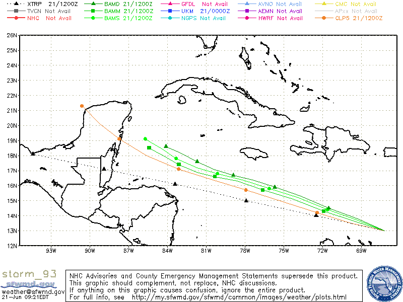
12 UTC BAMS
Wow,SHIP intensity up to 100kts in 120 hours.
290
WHXX01 KWBC 211846
CHGHUR
TROPICAL CYCLONE GUIDANCE MESSAGE
NWS TPC/NATIONAL HURRICANE CENTER MIAMI FL
1846 UTC MON JUN 21 2010
DISCLAIMER...NUMERICAL MODELS ARE SUBJECT TO LARGE ERRORS.
PLEASE REFER TO NHC OFFICIAL FORECASTS FOR TROPICAL CYCLONE
AND SUBTROPICAL CYCLONE INFORMATION.
ATLANTIC OBJECTIVE AIDS FOR
DISTURBANCE INVEST (AL932010) 20100621 1800 UTC
...00 HRS... ...12 HRS... ...24 HRS. .. ...36 HRS...
100621 1800 100622 0600 100622 1800 100623 0600
LAT LON LAT LON LAT LON LAT LON
BAMS 13.5N 67.8W 14.2N 69.9W 15.1N 72.2W 15.9N 74.3W
BAMD 13.5N 67.8W 14.4N 70.0W 15.4N 72.2W 16.1N 74.2W
BAMM 13.5N 67.8W 14.2N 70.0W 15.1N 72.3W 15.8N 74.5W
LBAR 13.5N 67.8W 14.5N 69.8W 15.7N 72.2W 16.6N 74.5W
SHIP 25KTS 32KTS 41KTS 51KTS
DSHP 25KTS 32KTS 41KTS 51KTS
...48 HRS... ...72 HRS... ...96 HRS. .. ..120 HRS...
100623 1800 100624 1800 100625 1800 100626 1800
LAT LON LAT LON LAT LON LAT LON
BAMS 16.6N 76.6W 17.8N 80.6W 19.1N 84.0W 20.3N 87.0W
BAMD 16.6N 76.0W 17.3N 79.3W 18.1N 82.2W 18.9N 84.6W
BAMM 16.4N 76.6W 17.3N 80.2W 18.3N 83.3W 19.2N 86.0W
LBAR 17.4N 76.6W 18.3N 80.5W 20.3N 83.7W 22.4N 85.7W
SHIP 61KTS 76KTS 89KTS 100KTS
DSHP 61KTS 76KTS 89KTS 100KTS
...INITIAL CONDITIONS...
LATCUR = 13.5N LONCUR = 67.8W DIRCUR = 290DEG SPDCUR = 11KT
LATM12 = 12.8N LONM12 = 65.9W DIRM12 = 285DEG SPDM12 = 12KT
LATM24 = 12.3N LONM24 = 63.2W
WNDCUR = 25KT RMAXWD = 30NM WNDM12 = 25KT
CENPRS = 1010MB OUTPRS = 1011MB OUTRAD = 120NM SDEPTH = S
RD34NE = 0NM RD34SE = 0NM RD34SW = 0NM RD34NW = 0NM
0 likes
Visit the Caribbean-Central America Weather Thread where you can find at first post web cams,radars
and observations from Caribbean basin members Click Here
and observations from Caribbean basin members Click Here

As far as tracking to the right, of course anything is possible. Looks like the Euro has a Texas trough dropping down toward the gulf. Troughs don't usually dig this time of year but a disturbance in the gulf might tend to draw a trough further south than usual. If anything develops in the Caribbean, the longer it hangs around in the gulf the more time there is for a trough to drop down and pull it NE.
0 likes

-
lester

- S2K Supporter

- Posts: 1305
- Age: 37
- Joined: Sat Aug 27, 2005 5:21 pm
- Location: Washington, DC
- Contact:
Re: ATL : INVEST 93L - MODELS
cycloneye wrote:12 UTC BAMS
Wow,SHIP inyensity up to 100kts in 120 hours.
290
WHXX01 KWBC 211846
CHGHUR
TROPICAL CYCLONE GUIDANCE MESSAGE
NWS TPC/NATIONAL HURRICANE CENTER MIAMI FL
1846 UTC MON JUN 21 2010
DISCLAIMER...NUMERICAL MODELS ARE SUBJECT TO LARGE ERRORS.
PLEASE REFER TO NHC OFFICIAL FORECASTS FOR TROPICAL CYCLONE
AND SUBTROPICAL CYCLONE INFORMATION.
ATLANTIC OBJECTIVE AIDS FOR
DISTURBANCE INVEST (AL932010) 20100621 1800 UTC
...00 HRS... ...12 HRS... ...24 HRS. .. ...36 HRS...
100621 1800 100622 0600 100622 1800 100623 0600
LAT LON LAT LON LAT LON LAT LON
BAMS 13.5N 67.8W 14.2N 69.9W 15.1N 72.2W 15.9N 74.3W
BAMD 13.5N 67.8W 14.4N 70.0W 15.4N 72.2W 16.1N 74.2W
BAMM 13.5N 67.8W 14.2N 70.0W 15.1N 72.3W 15.8N 74.5W
LBAR 13.5N 67.8W 14.5N 69.8W 15.7N 72.2W 16.6N 74.5W
SHIP 25KTS 32KTS 41KTS 51KTS
DSHP 25KTS 32KTS 41KTS 51KTS
...48 HRS... ...72 HRS... ...96 HRS. .. ..120 HRS...
100623 1800 100624 1800 100625 1800 100626 1800
LAT LON LAT LON LAT LON LAT LON
BAMS 16.6N 76.6W 17.8N 80.6W 19.1N 84.0W 20.3N 87.0W
BAMD 16.6N 76.0W 17.3N 79.3W 18.1N 82.2W 18.9N 84.6W
BAMM 16.4N 76.6W 17.3N 80.2W 18.3N 83.3W 19.2N 86.0W
LBAR 17.4N 76.6W 18.3N 80.5W 20.3N 83.7W 22.4N 85.7W
SHIP 61KTS 76KTS 89KTS [b]100KTS
DSHP 61KTS 76KTS 89KTS 100KTS
...INITIAL CONDITIONS...
LATCUR = 13.5N LONCUR = 67.8W DIRCUR = 290DEG SPDCUR = 11KT
LATM12 = 12.8N LONM12 = 65.9W DIRM12 = 285DEG SPDM12 = 12KT
LATM24 = 12.3N LONM24 = 63.2W
WNDCUR = 25KT RMAXWD = 30NM WNDM12 = 25KT
CENPRS = 1010MB OUTPRS = 1011MB OUTRAD = 120NM SDEPTH = S
RD34NE = 0NM RD34SE = 0NM RD34SW = 0NM RD34NW = 0NM
[/b]
Wow!
0 likes
-
Wx_Warrior
- Category 5
- Posts: 2718
- Joined: Thu Aug 03, 2006 3:58 pm
- Location: Beaumont, TX

-
StormClouds63
- Category 2

- Posts: 583
- Age: 62
- Joined: Tue May 13, 2008 11:56 am
- Location: Southwest Louisiana
Re: ATL : INVEST 93L - MODELS
Ivanhater wrote:168..weaker on this run
Latest forecast tracks for 93AL looks more like Emily (2005) in terms of direction (not intensity, of course).
Also, a strong system in the Eastern Pacific on this latest run (above) of the Euro, but a very unimpressive 93AL.
Last edited by StormClouds63 on Mon Jun 21, 2010 2:06 pm, edited 2 times in total.
0 likes
-
Wx_Warrior
- Category 5
- Posts: 2718
- Joined: Thu Aug 03, 2006 3:58 pm
- Location: Beaumont, TX
-
HURAKAN

- Professional-Met

- Posts: 46084
- Age: 39
- Joined: Thu May 20, 2004 4:34 pm
- Location: Key West, FL
- Contact:
Code: Select all
                    *   ATLANTIC SHIPS INTENSITY FORECAST       *
                    *      GOES DATA AVAILABLE                  *
                    *      OHC  DATA AVAILABLE                  *
                    *  INVEST      AL932010  06/21/10  18 UTC   *

TIME (HR)          0     6    12    18    24    36    48    60    72    84    96   108   120
V (KT) NO LAND    25    28    32    35    41    51    61    71    76    83    89    94   100
V (KT) LAND       25    28    32    35    41    51    61    71    76    83    89    94   100
V (KT) LGE mod    25    26    28    30    32    38    46    57    69    84    98   108   111

SHEAR (KT)         8    13    10     3     2     5    10     7     6     3     5     3     7
SHEAR ADJ (KT)    -1    -3    -6     0    -1     0    -4    -1    -2    -4    -3    -1     0
SHEAR DIR        132   172   193   230    37   275   350   315    10   333    33   345    38
SST (C)         29.0  29.0  29.0  29.0  28.9  28.9  29.0  29.2  29.3  29.3  29.4  29.6  29.3
POT. INT. (KT)   152   152   152   152   151   150   152   155   156   156   157   161   155
ADJ. POT. INT.   150   151   151   151   148   146   146   147   147   146   146   148   143
200 MB T (C)   -52.3 -52.0 -52.5 -52.9 -52.2 -52.4 -52.2 -52.5 -52.5 -52.7 -52.8 -52.8 -52.7
TH_E DEV (C)       7     7     6     6     8     7     9    10    11    10    12    11    13
700-500 MB RH     84    83    82    80    81    79    77    75    71    70    67    68    65
GFS VTEX (KT)      0  LOST  LOST  LOST  LOST  LOST  LOST  LOST  LOST  LOST  LOST  LOST  LOST
850 MB ENV VOR    81    83    86    84    87    83    71    65    62    65    44    39    16
200 MB DIV        81    79    96    87    92    71    55    22    12     3     6    -8     2
LAND (KM)        247   228   233   246   293   255   155   131   224   331   293   306   154
LAT (DEG N)     13.5  13.9  14.2  14.7  15.1  15.8  16.4  16.9  17.3  17.7  18.3  18.8  19.2
LONG(DEG W)     67.8  68.9  70.0  71.2  72.3  74.5  76.6  78.5  80.2  81.8  83.3  84.6  86.0
STM SPEED (KT)    10    11    12    12    11    11    10     9     8     8     7     6     7
HEAT CONTENT      61    64    77    89    89    70    85   108   108   100   106    95    94

  FORECAST TRACK FROM BAMM      INITIAL HEADING/SPEED (DEG/KT):290/ 11      CX,CY:  -9/  4
  T-12 MAX WIND:  25            PRESSURE OF STEERING LEVEL (MB):  559  (MEAN=624)
  GOES IR BRIGHTNESS TEMP. STD DEV.  50-200 KM RAD:   9.6 (MEAN=14.5)
  % GOES IR PIXELS WITH T < -20 C    50-200 KM RAD:  96.0 (MEAN=65.0)

                        INDIVIDUAL CONTRIBUTIONS TO INTENSITY CHANGE
                         6   12   18   24   36   48   60   72   84   96  108  120
                        ----------------------------------------------------------
  SAMPLE MEAN CHANGE     1.   2.   3.   4.   6.   8.   9.  11.  11.  12.  13.  13.
  SST POTENTIAL          0.   0.   0.   1.   6.  13.  21.  26.  31.  34.  37.  38.
  VERTICAL SHEAR MAG     1.   2.   4.   5.   8.   9.  11.  11.  13.  14.  15.  15.
  VERTICAL SHEAR ADJ     0.   1.   1.   1.   1.   2.   3.   3.   4.   3.   3.   2.
  VERTICAL SHEAR DIR     0.   0.  -1.  -1.  -1.  -1.  -1.  -1.   0.   1.   0.   1.
  PERSISTENCE            0.  -1.  -1.  -1.  -1.  -1.  -1.  -1.  -1.   0.   0.   0.
  200/250 MB TEMP.       0.  -1.  -1.  -1.  -2.  -2.  -3.  -3.  -3.  -3.  -3.  -3.
  THETA_E EXCESS         0.  -1.  -1.  -1.  -2.  -2.  -3.  -4.  -4.  -4.  -4.  -4.
  700-500 MB RH          0.   0.   0.  -1.  -1.  -2.  -2.  -2.  -2.  -2.  -2.  -2.
  GFS VORTEX TENDENCY    0.   0.   0.   0.  -1.  -1.  -1.  -1.  -1.  -2.  -2.  -2.
  850 MB ENV VORTICITY   0.   1.   1.   2.   2.   3.   4.   4.   5.   5.   5.   4.
  200 MB DIVERGENCE      0.   1.   2.   3.   4.   5.   5.   5.   5.   4.   3.   2.
  ZONAL STORM MOTION     0.   0.   0.   1.   1.   1.   1.   2.   2.   2.   2.   2.
  STEERING LEVEL PRES    0.   0.   0.   0.   0.   1.   1.   1.   1.   1.   1.   0.
  DAYS FROM CLIM. PEAK   0.   0.   0.   0.   0.  -1.  -1.  -1.  -1.  -1.   0.  -1.
  GOES PREDICTORS        1.   3.   4.   4.   4.   4.   3.   2.   1.   1.   1.   2.
  OCEAN HEAT CONTENT     0.   0.   0.   0.   0.   1.   0.  -1.  -2.  -1.   2.   7.
                        ----------------------------------------------------------
  TOTAL CHANGE           3.   7.  10.  16.  26.  36.  46.  51.  58.  64.  69.  75.

   ** 2010 ATLANTIC RI INDEX AL932010 INVEST     06/21/10  18 UTC **
           ( 30 KT OR MORE MAX WIND INCREASE IN NEXT 24 HR)

 12 HR PERSISTENCE (KT):   0.0 Range:-45.0 to  30.0 Scaled/Wgted Val:  0.6/  1.3
 850-200 MB SHEAR (KT) :   7.0 Range: 26.2 to   3.2 Scaled/Wgted Val:  0.8/  1.0
 D200 (10**7s-1)       :  87.0 Range:-21.0 to 140.0 Scaled/Wgted Val:  0.7/  1.0
 POT = MPI-VMAX (KT)   : 125.2 Range: 33.5 to 126.5 Scaled/Wgted Val:  1.0/  0.7
 850-700 MB REL HUM (%):  84.2 Range: 56.0 to  85.0 Scaled/Wgted Val:  1.0/  0.6
 % area w/pixels <-30 C:  86.0 Range: 17.0 to 100.0 Scaled/Wgted Val:  0.8/  0.1
 STD DEV OF IR BR TEMP :   9.6 Range: 30.6 to   3.2 Scaled/Wgted Val:  0.8/  1.3
 Heat content (KJ/cm2) :  76.0 Range:  0.0 to 130.0 Scaled/Wgted Val:  0.6/  0.0

 Prob of RI for 25 kt RI threshold=    66% is   5.3 times the sample mean(12.6%)
 Prob of RI for 30 kt RI threshold=    55% is   6.8 times the sample mean( 8.1%)
 Prob of RI for 35 kt RI threshold=    39% is   8.2 times the sample mean( 4.8%)
 Prob of RI for 40 kt RI threshold=    21% is   6.1 times the sample mean( 3.4%)

   ##         ANNULAR HURRICANE INDEX (AHI) AL932010 INVEST     06/21/10  18 UTC         ##
   ## STORM NOT ANNULAR, SCREENING STEP FAILED, NPASS=4 NFAIL=3                          ##
   ## AHI=  0   (AHI OF 100 IS BEST FIT TO ANN. STRUC., 1 IS MARGINAL, 0 IS NOT ANNULAR) ##
   ##     ANNULAR INDEX RAN NORMALLY

** PROBABILITY OF SECONDARY EYEWALL FORMATION AL932010 INVEST     06/21/2010  00 UTC **
TIME        0-12h   0-24h   0-36h   0-48h       EXPERIMENTAL PRODUCT (PrSEFoNe-model)
CLIMO (%)     0       0       0       0    <--- PROBABILITY BASED ON INTENSITY ONLY
PROB  (%)     0       0       0       0    <--- FULL MODEL RAN NORMALLY
0 likes
-
cycloneye
- Admin
- Posts: 149478
- Age: 69
- Joined: Thu Oct 10, 2002 10:54 am
- Location: San Juan, Puerto Rico
Re: ATL : INVEST 93L - MODELS
240 hours.An about face from ECMWF on intensity,from a strong hurricane at 00z to almost nothing at 12z.

0 likes
Visit the Caribbean-Central America Weather Thread where you can find at first post web cams,radars
and observations from Caribbean basin members Click Here
and observations from Caribbean basin members Click Here
-
tolakram
- Admin
- Posts: 20185
- Age: 62
- Joined: Sun Aug 27, 2006 8:23 pm
- Location: Florence, KY (name is Mark)
Re: ATL : INVEST 93L - MODELS
No model support for the first set of runs.
Hurakan, no more green name?
Hurakan, no more green name?
0 likes
M a r k
- - - - -
Join us in chat: Storm2K Chatroom Invite. Android and IOS apps also available.
The posts in this forum are NOT official forecasts and should not be used as such. Posts are NOT endorsed by any professional institution or STORM2K.org. For official information and forecasts, please refer to NHC and NWS products.
-
Wx_Warrior
- Category 5
- Posts: 2718
- Joined: Thu Aug 03, 2006 3:58 pm
- Location: Beaumont, TX

Re: ATL : INVEST 93L - MODELS
yeah the EURO backs way off.....so no consistency yet from any of the models....
GFS, GFDL,HWRF....nada to be concerned about...
GFS, GFDL,HWRF....nada to be concerned about...
0 likes
-
Wx_Warrior
- Category 5
- Posts: 2718
- Joined: Thu Aug 03, 2006 3:58 pm
- Location: Beaumont, TX
Re: ATL : INVEST 93L - MODELS
Until something decent develops, models will be all over the place.
0 likes
-
gatorcane

- S2K Supporter
- Posts: 23708
- Age: 48
- Joined: Sun Mar 13, 2005 3:54 pm
- Location: Boca Raton, FL
Now that the ECMWF shows no development on this last run, then it appears no model is developing 93L. I do see that upper-level conditions are going to become more favorable for 93L as it heads west below the shear axis that sits across the Greater Antilles to the north. SSTs are plenty warm as well and dry air appears to not be an issue. It certainly has a chance as it heads into the Western Caribbean, but I think 30% from the NHC is right on at the moment. I don't have any concern yet.
0 likes
-
wxman22

- Category 5
- Posts: 1939
- Joined: Mon Jan 30, 2006 12:39 am
- Location: Wichita Falls, TX
- Contact:
Re: ATL : INVEST 93L - MODELS
Looks like Euro is back to reality showing tropical Storm towards the Texas coast.This could be one of those situations when the strength of the storm could really determine where it ultimately goes.(Weaker system moves more west Stronger system moves more north and east.)


0 likes
Who is online
Users browsing this forum: No registered users and 55 guests