ATL: TROPICAL DEPRESSION ALEX - DISCUSSION

Moderator: S2k Moderators

Message
Author
rockyman
Category 5
Category 5
Posts: 1967
Joined: Thu Jun 26, 2003 12:24 pm
Location: Dauphin Island, AL

Re: ATL: INVEST 93L - DISCUSSION

#801 Postby rockyman » Wed Jun 23, 2010 8:10 pm

cycloneye wrote:Is the first time that 93L has the pressure down to 1009 mbs at Best Track.

AL, 93, 2010062400, , BEST, 0, 170N, 795W, 25, 1009 WV

ftp://ftp.tpc.ncep.noaa.gov/atcf/tcweb/ ... 010.invest


Hey, Luis...what's the "34 NEQ" from your link?...this is the first time it hasn't shown "0" in that colum
0 likes   

User avatar
TeamPlayersBlue
Category 5
Category 5
Posts: 3445
Joined: Tue Feb 02, 2010 1:44 am
Location: Denver/Applewood, CO

#802 Postby TeamPlayersBlue » Wed Jun 23, 2010 8:17 pm

I think in the next round of increased convection, we will see this storm really come together. Once it 'explodes' again, i dont see it dying again
0 likes   
Personal Forecast Disclaimer:
The posts in this forum are NOT official forecast and should not be used as such. They are just the opinion of the poster and may or may not be backed by sound meteorological data. They are NOT endorsed by any professional institution or storm2k.org. For official information, please refer to the NHC and NWS products.

tolakram
Admin
Admin
Posts: 20010
Age: 62
Joined: Sun Aug 27, 2006 8:23 pm
Location: Florence, KY (name is Mark)

Re: ATL: INVEST 93L - DISCUSSION

#803 Postby tolakram » Wed Jun 23, 2010 8:17 pm

One more for the evening. larger version of the last visible for the evening. 720P should be available for this one.

[youtube]http://www.youtube.com/watch?v=6-p0kcuW1iQ[/youtube]
0 likes   
M a r k
- - - - -
Join us in chat: Storm2K Chatroom Invite. Android and IOS apps also available.

The posts in this forum are NOT official forecasts and should not be used as such. Posts are NOT endorsed by any professional institution or STORM2K.org. For official information and forecasts, please refer to NHC and NWS products.

User avatar
cycloneye
Admin
Admin
Posts: 145355
Age: 68
Joined: Thu Oct 10, 2002 10:54 am
Location: San Juan, Puerto Rico

Re: ATL: INVEST 93L - DISCUSSION

#804 Postby cycloneye » Wed Jun 23, 2010 8:18 pm

rockyman wrote:
cycloneye wrote:Is the first time that 93L has the pressure down to 1009 mbs at Best Track.

AL, 93, 2010062400, , BEST, 0, 170N, 795W, 25, 1009 WV

ftp://ftp.tpc.ncep.noaa.gov/atcf/tcweb/ ... 010.invest


Hey, Luis...what's the "34 NEQ" from your link?...this is the first time it hasn't shown "0" in that colum


I am not a guru on how atcf works the Best Track thing,but my guess is that is related to any more updates in any particular run and the tropical models (The BAMS) can make the run at that particular time. If I am wrong,I would like to have any of the pro mets to come. :)
0 likes   
Visit the Caribbean-Central America Weather Thread where you can find at first post web cams,radars
and observations from Caribbean basin members Click Here

User avatar
WeatherLovingDoc
S2K Supporter
S2K Supporter
Posts: 453
Joined: Fri Sep 05, 2008 10:08 pm
Location: Washington D.C.

Re: ATL: INVEST 93L - DISCUSSION

#805 Postby WeatherLovingDoc » Wed Jun 23, 2010 8:24 pm

Nice last visual tolakram. Think I can almost see that naked LLC. I still need Latitudes and Longitudes from my fellow experts to truly site these findings. Been here almost a year, but I'm gaining in knowledge. Thanks-WLD
0 likes   

Dean4Storms
S2K Supporter
S2K Supporter
Posts: 6358
Age: 62
Joined: Sun Aug 31, 2003 1:01 pm
Location: Miramar Bch. FL

Re: ATL: INVEST 93L - DISCUSSION

#806 Postby Dean4Storms » Wed Jun 23, 2010 8:25 pm

There is a small area of dry air just west of this wave in the western Carib. Sea., between it and the slight shear it might be what is holding this wave back so far.
0 likes   

User avatar
tailgater
S2K Supporter
S2K Supporter
Posts: 3339
Joined: Sun Jul 11, 2004 9:13 pm
Location: St. Amant La.

Re: ATL: INVEST 93L - DISCUSSION

#807 Postby tailgater » Wed Jun 23, 2010 8:31 pm

Conditions at 42057 as of
(8:50 pm EDT on 06/23/2010)
0050 GMT on 06/24/2010:
Wind Direction (WDIR): NNE ( 20 deg true )
Wind Speed (WSPD): 11.7 kts
Wind Gust (GST): 13.6 kts
Wave Height (WVHT): 3.3 ft
Dominant Wave Period (DPD): 7 sec
Average Period (APD): 5.1 sec
Atmospheric Pressure (PRES): 29.84 in

Pressure rising as expected but northly winds ?
Things are starting to come together, I would expect this Invest to be on the cusp of becoming our first TD of the season by this time tomorrow. But I'm just a long time gawker.
850mb vorticity, less impressive.
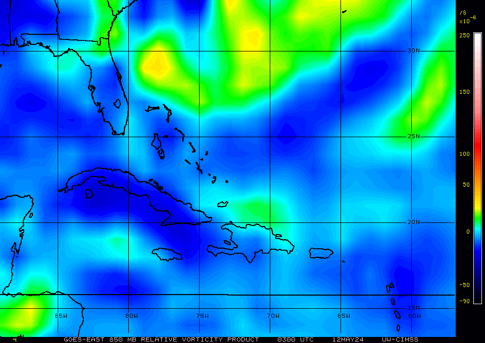
Image
0 likes   
The following post is NOT an official forecast and should not be used as such. It is just the opinion of the poster and may or may not be backed by sound meteorological data. It is NOT endorsed by any professional institution including storm2k.org For Official Information please refer to the NHC and NWS products.

Nederlander
S2K Supporter
S2K Supporter
Posts: 1250
Joined: Sat Jul 19, 2008 4:28 pm
Location: Conroe, TX

Re: ATL: INVEST 93L - DISCUSSION

#808 Postby Nederlander » Wed Jun 23, 2010 8:58 pm

I think 83W-84W is going to be the mark for this thing to get its act together...

Personal Forecast Disclaimer:
The posts in this forum are NOT official forecast and should not be used as such. They are just the opinion of the poster and may or may not be backed by sound meteorological data. They are NOT endorsed by any professional institution or storm2k.org. For official information, please refer to the NHC and NWS products.
0 likes   

fernandingas
Tropical Wave
Tropical Wave
Posts: 3
Joined: Sun Jun 13, 2010 8:11 pm

Re: ATL: INVEST 93L - DISCUSSION

#809 Postby fernandingas » Wed Jun 23, 2010 9:06 pm

Hello friends. I have in my hand SMN bulletin Mexico. His prediction is that after spending the Yucatan Peninsula is better organized and become a Hurricane. This is the link
http://smn.cna.gob.mx/boletin/discusion/discusion.html
0 likes   

User avatar
wxman57
Moderator-Pro Met
Moderator-Pro Met
Posts: 22979
Age: 67
Joined: Sat Jun 21, 2003 8:06 pm
Location: Houston, TX (southwest)

Re: ATL: INVEST 93L - DISCUSSION

#810 Postby wxman57 » Wed Jun 23, 2010 9:27 pm

Just in the last few hours, I'm seeing signs of organization south of Jamaica. Squalls are diminishing near the two mid-level centers to the east and concentrating south of Jamaica. Could be the beginning of something. Let's see if it continues tonight and tomorrow.
0 likes   

User avatar
Ivanhater
Storm2k Moderator
Storm2k Moderator
Posts: 11161
Age: 38
Joined: Fri Jul 01, 2005 8:25 am
Location: Pensacola

Re: ATL: INVEST 93L - DISCUSSION

#811 Postby Ivanhater » Wed Jun 23, 2010 9:33 pm

wxman57 wrote:Just in the last few hours, I'm seeing signs of organization south of Jamaica. Squalls are diminishing near the two mid-level centers to the east and concentrating south of Jamaica. Could be the beginning of something. Let's see if it continues tonight and tomorrow.


Hmmm. That seems a bit earlier than even you thought. I would like to see a nice burst, but I don't think this is that type of system, at least not yet. It may just be a large monsoon type system in the Caribbean right now that needs to congeal; which may have started.
0 likes   
Michael

ozonepete
Professional-Met
Professional-Met
Posts: 4743
Joined: Mon Sep 07, 2009 3:23 pm
Location: From Ozone Park, NYC / Now in Brooklyn, NY

Re: ATL: INVEST 93L - DISCUSSION

#812 Postby ozonepete » Wed Jun 23, 2010 9:35 pm

wxman57 wrote:Just in the last few hours, I'm seeing signs of organization south of Jamaica. Squalls are diminishing near the two mid-level centers to the east and concentrating south of Jamaica. Could be the beginning of something. Let's see if it continues tonight and tomorrow.


Hey wxman57, I just saw the same thing and came on in here to see what was going on. I agree with you.
0 likes   

User avatar
bahamaswx
Category 5
Category 5
Posts: 1542
Joined: Sat Sep 13, 2003 1:11 am
Location: Georgetown, Bahamas

#813 Postby bahamaswx » Wed Jun 23, 2010 9:46 pm

I can't believe the amount of energy still hanging out in the eastern caribbean.
0 likes   

Weatherfreak000

#814 Postby Weatherfreak000 » Wed Jun 23, 2010 9:49 pm

93L is definitely consolidating.
0 likes   

Ikester
Professional-Met
Professional-Met
Posts: 361
Age: 39
Joined: Mon Jun 21, 2010 5:00 pm
Location: Jacksonville, FL

Re: ATL: INVEST 93L - DISCUSSION

#815 Postby Ikester » Wed Jun 23, 2010 9:50 pm

I've used the analogy before....if you stir a cup of coffee long enough, the circulation will eventually reach the bottom of the cup.
0 likes   

User avatar
tailgater
S2K Supporter
S2K Supporter
Posts: 3339
Joined: Sun Jul 11, 2004 9:13 pm
Location: St. Amant La.

Re: ATL: INVEST 93L - DISCUSSION

#816 Postby tailgater » Wed Jun 23, 2010 9:50 pm

http://mkwc.ifa.hawaii.edu/satellite/sa ... verlay=off
This WV loop shows a Upper low in the SE GOM backing off to the west, as it moves out the shear zone should move out with it. It also shows the dry air slot that 93l is currently passing through.
0 likes   
The following post is NOT an official forecast and should not be used as such. It is just the opinion of the poster and may or may not be backed by sound meteorological data. It is NOT endorsed by any professional institution including storm2k.org For Official Information please refer to the NHC and NWS products.

User avatar
brunota2003
S2K Supporter
S2K Supporter
Posts: 9476
Age: 34
Joined: Sat Jul 30, 2005 9:56 pm
Location: Stanton, KY...formerly Havelock, NC
Contact:

Re: Re:

#817 Postby brunota2003 » Wed Jun 23, 2010 9:55 pm

wxman57 wrote:
brunota2003 wrote:I don't get it...these waves have had near prime conditions (according to current standards) to develop, and then even intensify. Little dry air, hot SSTs, low shear, low pressures...heck, some even already had a low pressure on them! Yet they keep failing...why?

What criteria have we overlooked in the past that is clearly not there currently?


We weren't expecting it to come together until Friday. Today is Wednesday. It's consolidating very slowly. Come back Friday.

Yes, but I was talking more in general. Something seems to be in the EPac that the Atlantic is currently lacking, but what is it? The Atlantic is trying it's darnedest to pop something off with not only this wave, but other waves as well, then the waves move into the EPac and BOOM...system. Conditions between the two basins are not that terribly different, so the EPac must have something that the Atlantic is lacking. 10 to 15 knots of shear should not prevent a system (though it would be lopsided), from forming when there is little dry air, hot ssts, low background pressures, etc.

It constantly happened in the past...what's different this time? (Besides the countless prayers being thrown up all across the Gulf)
0 likes   

Brent
S2K Supporter
S2K Supporter
Posts: 38090
Age: 36
Joined: Sun May 16, 2004 10:30 pm
Location: Tulsa Oklahoma
Contact:

Re: ATL: INVEST 93L - DISCUSSION

#818 Postby Brent » Wed Jun 23, 2010 10:00 pm

wxman57 wrote:Just in the last few hours, I'm seeing signs of organization south of Jamaica. Squalls are diminishing near the two mid-level centers to the east and concentrating south of Jamaica. Could be the beginning of something. Let's see if it continues tonight and tomorrow.


I just got home from work, looked at it, and saw the same. I will see if it persists overnight, but this is the best it has looked in 2 days, no denying that.
0 likes   
#neversummer

User avatar
Ivanhater
Storm2k Moderator
Storm2k Moderator
Posts: 11161
Age: 38
Joined: Fri Jul 01, 2005 8:25 am
Location: Pensacola

Re: ATL: INVEST 93L - DISCUSSION

#819 Postby Ivanhater » Wed Jun 23, 2010 10:02 pm

We need some pictures up in here

Image
0 likes   
Michael

Ikester
Professional-Met
Professional-Met
Posts: 361
Age: 39
Joined: Mon Jun 21, 2010 5:00 pm
Location: Jacksonville, FL

Re: ATL: INVEST 93L - DISCUSSION

#820 Postby Ikester » Wed Jun 23, 2010 10:07 pm

Up in here, up in here... :lol:
Image
0 likes   


Return to “2010”

Who is online

Users browsing this forum: No registered users and 5 guests