BEGIN
NHC_ATCF
invest_al942010.invest
FSTDA
R
U
040
010
0000
201006251452
NONE
NOTIFY=ATRP
END
INVEST, AL, L, , , , , 94, 2010, DB, O, 2010062512, 9999999999, , , , , , METWATCH, , AL942010
AL, 94, 2010062418, , BEST, 0, 152N, 549W, 25, 1012, DB, 0, , 0, 0, 0, 0,
AL, 94, 2010062500, , BEST, 0, 161N, 560W, 25, 1012, DB, 0, , 0, 0, 0, 0,
AL, 94, 2010062506, , BEST, 0, 169N, 570W, 25, 1012, DB, 0, , 0, 0, 0, 0,
AL, 94, 2010062512, , BEST, 0, 178N, 578W, 25, 1013, DB, 34, NEQ, 0, 0, 0, 0, 1014, 120, 45, 0, 0, L, 0, , 0, 0, INVEST
ATL: INVEST 94L - DISCUSSION
Moderator: S2k Moderators
-
Parungo
- Tropical Low

- Posts: 20
- Age: 54
- Joined: Sun Jul 26, 2009 8:12 am
- Location: Seville, Spain
- Contact:
ATL: INVEST 94L - DISCUSSION
0 likes
-
cwachal

This is the sort of system that quite possibly will develop when it heads northwards around the subtropical high in about 3-5 days time, would be short lived regardless I'd have thought.
0 likes
Personal Forecast Disclaimer:
The posts in this forum are NOT official forecast and should not be used as such. They are just the opinion of the poster and may or may not be backed by sound meteorological data. They are NOT endorsed by any professional institution or storm2k.org. For official information, please refer to the NHC and NWS products
The posts in this forum are NOT official forecast and should not be used as such. They are just the opinion of the poster and may or may not be backed by sound meteorological data. They are NOT endorsed by any professional institution or storm2k.org. For official information, please refer to the NHC and NWS products
-
Bocadude85

- Category 5

- Posts: 2991
- Age: 39
- Joined: Mon Apr 18, 2005 2:20 pm
- Location: Honolulu,Hi
Re:
cwachal wrote:here we go atl is going to get active here really fast we could have 2 named storms by Sunday night at this rate
I think its going to take awhile for this one to develop.. it may have a chance in a few days once it gets away from the shear.
0 likes
-
Aquawind
- Category 5
- Posts: 6714
- Age: 62
- Joined: Mon Jun 16, 2003 10:41 pm
- Location: Salisbury, NC
- Contact:
Re:
KWT wrote:This is the sort of system that quite possibly will develop when it heads northwards around the subtropical high in about 3-5 days time, would be short lived regardless I'd have thought.
Agreed.. I don't expect it to stack with the ULL and it will have to get past the ULL and then possibly develop when it starts lifting out..
0 likes
-
johngaltfla

- Category 5
- Posts: 2073
- Joined: Sun Jul 10, 2005 9:17 pm
- Location: Sarasota County, FL
- Contact:
Re: ATL: INVEST 94L - DISCUSSION
Is it too late to withdraw that prediction for 31 named storms and change it to oh, like 50? 
This one is in a good spot as stated above once the ULL lifts out. I can not even begin to think what August will look like.
This one is in a good spot as stated above once the ULL lifts out. I can not even begin to think what August will look like.
0 likes
-
chzzdekr81

- S2K Supporter

- Posts: 189
- Joined: Sun Aug 30, 2009 7:54 pm
- Location: Orange, Texas (SETX)
- Contact:
If these two invests form into tropical storms before July starts, the season would start off just as the 2005 season did - 2 named storms in the first month of hurricane season.
Last edited by chzzdekr81 on Fri Jun 25, 2010 11:07 am, edited 1 time in total.
0 likes
I survived Rita, Humberto, Edouard, and Ike.
-
chzzdekr81
- S2K Supporter
- Posts: 189
- Joined: Sun Aug 30, 2009 7:54 pm
- Location: Orange, Texas (SETX)
- Contact:
Re: ATL: INVEST 94L - DISCUSSION
johngaltfla wrote:Is it too late to withdraw that prediction for 31 named storms and change it to oh, like 50?
This one is in a good spot as stated above once the ULL lifts out. I can not even begin to think what August will look like.
Lets just be thankful we only have two invests right now and not two major hurricanes like in the EPAC.
0 likes
I survived Rita, Humberto, Edouard, and Ike.
Re: ATL: INVEST 94L - DISCUSSION
This is the sort of system that quite possibly will develop when it heads northwards around the subtropical high in about 3-5 days time, would be short lived regardless I'd have thought.
KWT,
The 00Z GFS had 94L moving northward around the high (as you said) as a weak system by early next week...
And, per 93L the entire broad circulation is still moving west at about 10 kts (perhaps a little less than), so the GFS might be right that both remain weak - so far the GFS has done a good job with 93L, bucking the trend of many other models earlier this week (that had 93L as a hurricane by now)...
Frank
0 likes
-
vacanechaser

- Category 5
- Posts: 1461
- Joined: Wed Dec 03, 2003 9:34 pm
- Location: Portsmouth, Va
- Contact:
Re: ATL: INVEST 94L - DISCUSSION
Frank2 wrote: so far the GFS has done a good job with 93L, bucking the trend of many other models earlier this week (that had 93L as a hurricane by now)...
Frank
i dont remember that... not by this time... i think most ramped it up once into the gulf...
Jesse V. Bass III
http://www.vastormphoto.com
Hurricane Intercept Research Team
0 likes


-
lester

- S2K Supporter
- Posts: 1305
- Age: 37
- Joined: Sat Aug 27, 2005 5:21 pm
- Location: Washington, DC
- Contact:
A LARGE BUT DISORGANIZED AREA OF CLOUDINESS AND SHOWERS CENTERED
JUST EAST OF THE NORTHERN LEEWARD ISLANDS IS ASSOCIATED WITH A
TROPICAL WAVE INTERACTING WITH AN UPPER-LEVEL TROUGH. THIS SYSTEM
HAS THE POTENTIAL FOR SLOW DEVELOPMENT AS IT MOVES TOWARD THE
NORTHWEST AT 10 TO 15 MPH. THERE IS A LOW CHANCE...20 PERCENT...OF
THIS SYSTEM BECOMING A TROPICAL CYCLONE DURING THE NEXT 48 HOURS.
0 likes
-
HURAKAN

- Professional-Met

- Posts: 46084
- Age: 39
- Joined: Thu May 20, 2004 4:34 pm
- Location: Key West, FL
- Contact:
Re: ATL: INVEST 94L - DISCUSSION
963
ABNT20 KNHC 251750
TWOAT
TROPICAL WEATHER OUTLOOK
NWS TPC/NATIONAL HURRICANE CENTER MIAMI FL
200 PM EDT FRI JUN 25 2010
FOR THE NORTH ATLANTIC...CARIBBEAN SEA AND THE GULF OF MEXICO...
SATELLITE IMAGES AND SURFACE OBSERVATIONS INDICATE THAT THE LOW
PRESSURE AREA BETWEEN THE NORTHERN COAST OF HONDURAS AND GRAND
CAYMAN HAS BECOME BETTER ORGANIZED TODAY. AN AIR FORCE
RECONNAISSANCE PLANE IS CURRENTLY APPROACHING THE SYSTEM TO
DETERMINE IF A TROPICAL DEPRESSION HAS FORMED. REGARDLESS...
UPPER-LEVEL WINDS ARE BECOMING MORE CONDUCIVE FOR DEVELOPMENT AND A
TROPICAL DEPRESSION WILL LIKELY FORM AT ANY TIME LATER TODAY OR
SATURDAY. THERE IS A HIGH CHANCE...80 PERCENT...OF THIS SYSTEM
BECOMING A TROPICAL CYCLONE DURING THE NEXT 48 HOURS. THIS
SYSTEM...ACCOMPANIED BY HEAVY RAINS AND GUSTY WINDS...IS FORECAST
TO MOVE SLOWLY TOWARD THE WEST-NORTHWEST AND REACH THE YUCATAN
PENINSULA IN A DAY OR TWO. ALL INTERESTS IN THE NORTHWESTERN
CARIBBEAN SEA AND YUCATAN SHOULD MONITOR THE PROGRESS OF THIS
SYSTEM.
A LARGE BUT DISORGANIZED AREA OF CLOUDINESS AND SHOWERS CENTERED
JUST EAST OF THE NORTHERN LEEWARD ISLANDS IS ASSOCIATED WITH A
TROPICAL WAVE INTERACTING WITH AN UPPER-LEVEL TROUGH. THIS SYSTEM
HAS THE POTENTIAL FOR SLOW DEVELOPMENT AS IT MOVES TOWARD THE
NORTHWEST AT 10 TO 15 MPH. THERE IS A LOW CHANCE...20 PERCENT...OF
THIS SYSTEM BECOMING A TROPICAL CYCLONE DURING THE NEXT 48 HOURS.
ELSEWHERE...TROPICAL CYCLONE FORMATION IS NOT EXPECTED DURING THE
NEXT 48 HOURS.
$$
FORECASTER AVILA/ROBERTS
0 likes

Re: ATL: INVEST 94L - DISCUSSION
HURAKAN wrote:
Except for shear, everything else looks good
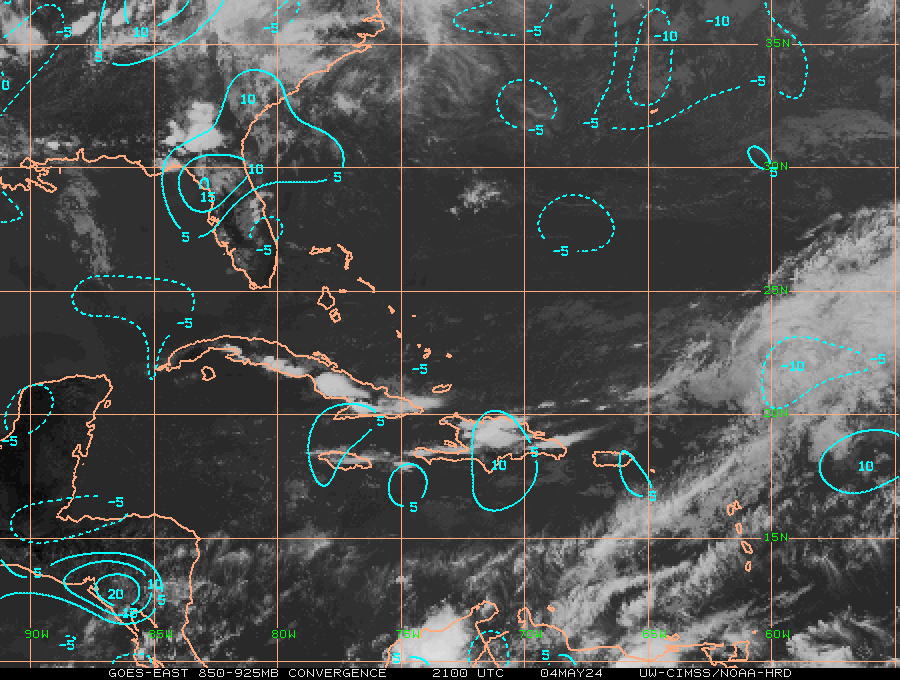
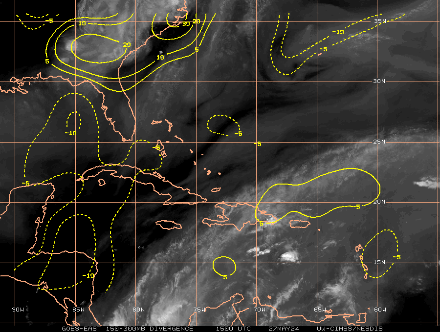
What do the first two images show?
0 likes

Re: ATL: INVEST 94L - DISCUSSION
A LARGE BUT DISORGANIZED AREA OF CLOUDINESS AND SHOWERS CENTERED
JUST EAST OF THE NORTHERN LEEWARD ISLANDS IS ASSOCIATED WITH A
TROPICAL WAVE INTERACTING WITH AN UPPER-LEVEL TROUGH. THIS SYSTEM
HAS THE POTENTIAL FOR SLOW DEVELOPMENT AS IT MOVES TOWARD THE
NORTHWEST AT 10 TO 15 MPH. THERE IS A LOW CHANCE...20 PERCENT...OF
THIS SYSTEM BECOMING A TROPICAL CYCLONE DURING THE NEXT 48 HOURS.
Up to 20%
0 likes
Re:
HURAKAN wrote:Convergence and Divergence, look in the bottom of the graphs and you will see the names
Is convergence where the winds split into different directions and divergence is where the winds come from different directions to the same point? At what level is the convergence/divergence, and what is the significance of it?
0 likes
-
HURAKAN
- Professional-Met
- Posts: 46084
- Age: 39
- Joined: Thu May 20, 2004 4:34 pm
- Location: Key West, FL
- Contact:
Re: Re:
I-wall wrote:HURAKAN wrote:Convergence and Divergence, look in the bottom of the graphs and you will see the names
Is convergence where the winds split into different directions and divergence is where the winds come from different directions to the same point? At what level is the convergence/divergence, and what is the significance of it?
Convergence or converge, is where winds come together at the surface, and divergence or diverge, is where winds separate at the upper levels, allowing the storm to "breath."
0 likes
Re: Re:
HURAKAN wrote:I-wall wrote:HURAKAN wrote:Convergence and Divergence, look in the bottom of the graphs and you will see the names
Is convergence where the winds split into different directions and divergence is where the winds come from different directions to the same point? At what level is the convergence/divergence, and what is the significance of it?
Convergence or converge, is where winds come together at the surface, and divergence or diverge, is where winds separate at the upper levels, allowing the storm to "breath."
Thanks Hurakan
0 likes
Who is online
Users browsing this forum: No registered users and 51 guests