
Yeah I think this will be a Mexicdo storm, but more on the north side of Mexico than south...the ECM doesn't develop it at all till it starts to move overland and thus is probably too far south in the first 48hrs...
I think the NHC probably deciding whether to go TD or Alex.
ATL: TROPICAL DEPRESSION ALEX - DISCUSSION
Moderator: S2k Moderators
0 likes
Personal Forecast Disclaimer:
The posts in this forum are NOT official forecast and should not be used as such. They are just the opinion of the poster and may or may not be backed by sound meteorological data. They are NOT endorsed by any professional institution or storm2k.org. For official information, please refer to the NHC and NWS products
The posts in this forum are NOT official forecast and should not be used as such. They are just the opinion of the poster and may or may not be backed by sound meteorological data. They are NOT endorsed by any professional institution or storm2k.org. For official information, please refer to the NHC and NWS products
-
greg_kfdm_tv
- Professional-Met

- Posts: 110
- Joined: Fri Aug 29, 2003 8:50 pm
- Location: Beaumont, Texas
- Contact:

Re: ATL: INVEST 93L - DISCUSSION
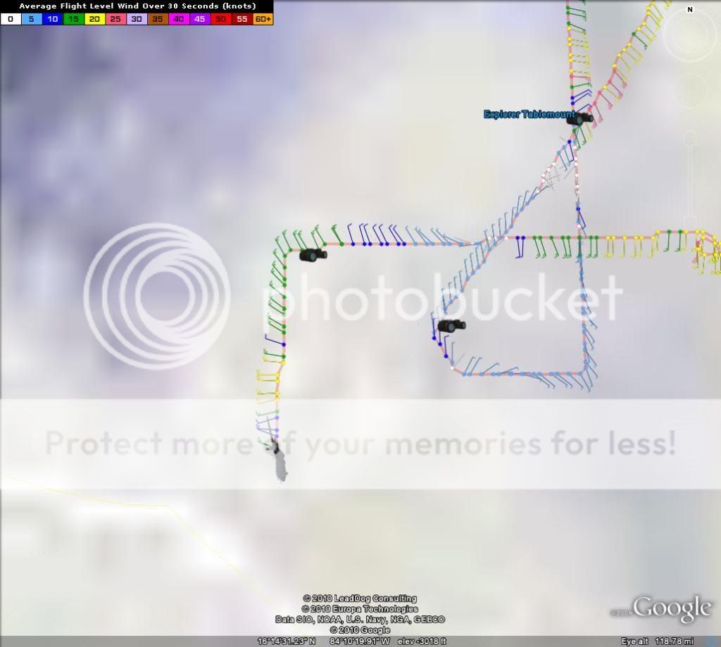
Lots of west winds of up to 20kts
0 likes
The following post is NOT an official forecast and should not be used as such. It is just the opinion of the poster and may or may not be backed by sound meteorological data. It is NOT endorsed by any professional institution including storm2k.org For Official Information please refer to the NHC and NWS products.
-
Air Force Met
- Military Met

- Posts: 4372
- Age: 57
- Joined: Tue Jul 08, 2003 9:30 am
- Location: Roan Mountain, TN
Re: Re:
RL3AO wrote:Dean4Storms wrote:With its satellite appearance, pressure and winds sustained over 35mph there has to be a west wind somewhere.
Even if there is a west wind, its not a depression IMO. It certainly doesn't have a well defined closed LLC.
Enough west winds for you yet?
All they had to do was head a little further south (think I said 30 miles or so)...now that they went down to 16N...we got winds from the west at 23 kts...that's pretty well defined.
0 likes

Re: Re:
KFDM Meteorologist wrote:I agree Chief!greg_kfdm_tv wrote:I still like an idea of an eventual landfall well south of Brownsville...around Tampico. Ridge to the north is just too strong and I do not see the models that turn Alex to be north being correct. Also, it already is far south in the Gulf of Honduras and is not gaining much latitude as it moves west-northwest.
Third the motion...likely Mexico bound.
0 likes


-
tolakram
- Admin

- Posts: 20186
- Age: 62
- Joined: Sun Aug 27, 2006 8:23 pm
- Location: Florence, KY (name is Mark)
Re: ATL: INVEST 93L - DISCUSSION
Looks like the center was further west than they thought, so now it's time to turn around and make another run at it.
0 likes
M a r k
- - - - -
Join us in chat: Storm2K Chatroom Invite. Android and IOS apps also available.
The posts in this forum are NOT official forecasts and should not be used as such. Posts are NOT endorsed by any professional institution or STORM2K.org. For official information and forecasts, please refer to NHC and NWS products.

Re: ATL: INVEST 93L - DISCUSSION
Oh my... it sure looks like it's happening!
http://www.goes.noaa.gov/HURRLOOPS/huirloop.html
Pretty impressive seeing both 93L/Alex and 94L in the shot, only 3.5 weeks into the season.
--
http://www.goes.noaa.gov/HURRLOOPS/huirloop.html
Pretty impressive seeing both 93L/Alex and 94L in the shot, only 3.5 weeks into the season.
--
0 likes
-
ConvergenceZone
.gif)
- Category 5

- Posts: 5241
- Joined: Fri Jul 29, 2005 1:40 am
- Location: Northern California
Re: Re:
Third the motion...likely Mexico bound.
Yea, it seems pretty unanimous regarding a Mexico landfall
Of couse once it forms, we will have the wobble wars starting....
Last edited by ConvergenceZone on Fri Jun 25, 2010 4:17 pm, edited 1 time in total.
0 likes
-
CrazyC83
- Professional-Met
- Posts: 34315
- Joined: Tue Mar 07, 2006 11:57 pm
- Location: Deep South, for the first time!
Re: Re:
HurrMark wrote:KFDM Meteorologist wrote:I agree Chief!greg_kfdm_tv wrote:I still like an idea of an eventual landfall well south of Brownsville...around Tampico. Ridge to the north is just too strong and I do not see the models that turn Alex to be north being correct. Also, it already is far south in the Gulf of Honduras and is not gaining much latitude as it moves west-northwest.
Third the motion...likely Mexico bound.
First landfall might even be in Belize.
0 likes
-
AdamFirst

- S2K Supporter

- Posts: 2490
- Age: 36
- Joined: Thu Aug 14, 2008 10:54 am
- Location: Port Saint Lucie, FL
I dont know if my eyes are deceiving me but it does look like 93L is slowly scooting northwest...but it's always hard to tell with these things.
0 likes
Dolphins Marlins Canes Golden Panthers HEAT
Andrew 1992 - Irene 1999 - Frances 2004 - Jeanne 2004 - Wilma 2005 - Fay 2008 - Isaac 2012 - Matthew 2016 - Irma 2017 - Dorian 2019 - Ian 2022 - Nicole 2022 - Milton 2024
Andrew 1992 - Irene 1999 - Frances 2004 - Jeanne 2004 - Wilma 2005 - Fay 2008 - Isaac 2012 - Matthew 2016 - Irma 2017 - Dorian 2019 - Ian 2022 - Nicole 2022 - Milton 2024
Yep looks a little south of what expected, brings credence to the ECM solution, though I think the 12z ECM was too far to the south in the end...
0 likes
Personal Forecast Disclaimer:
The posts in this forum are NOT official forecast and should not be used as such. They are just the opinion of the poster and may or may not be backed by sound meteorological data. They are NOT endorsed by any professional institution or storm2k.org. For official information, please refer to the NHC and NWS products
The posts in this forum are NOT official forecast and should not be used as such. They are just the opinion of the poster and may or may not be backed by sound meteorological data. They are NOT endorsed by any professional institution or storm2k.org. For official information, please refer to the NHC and NWS products
-
tolakram
- Admin
- Posts: 20186
- Age: 62
- Joined: Sun Aug 27, 2006 8:23 pm
- Location: Florence, KY (name is Mark)
Re: ATL: INVEST 93L - DISCUSSION
I'm a little shocked at just how many west winds where found and how much better this is looking.
Personal Forecast Disclaimer:
The posts in this forum are NOT official forecast and should not be used as such. They are just the opinion of the poster and may or may not be backed by sound meteorological data. They are NOT endorsed by any professional institution or storm2k.org. For official information, please refer to the NHC and NWS products.
This is not a forecast but I don't want to be caught with my disclaimer down.
Conditions down there are in record territory, I wonder just how fast this thing can develop?
0 likes
M a r k
- - - - -
Join us in chat: Storm2K Chatroom Invite. Android and IOS apps also available.
The posts in this forum are NOT official forecasts and should not be used as such. Posts are NOT endorsed by any professional institution or STORM2K.org. For official information and forecasts, please refer to NHC and NWS products.
- - - - -
Join us in chat: Storm2K Chatroom Invite. Android and IOS apps also available.
The posts in this forum are NOT official forecasts and should not be used as such. Posts are NOT endorsed by any professional institution or STORM2K.org. For official information and forecasts, please refer to NHC and NWS products.


-
Comanche

- Category 1

- Posts: 381
- Age: 54
- Joined: Wed Jul 06, 2005 9:33 am
- Location: Clear Lake City Texas
Re: ATL: INVEST 93L - DISCUSSION
tolakram wrote:I'm a little shocked at just how many west winds where found and how much better this is looking.
Personal Forecast Disclaimer:
The posts in this forum are NOT official forecast and should not be used as such. They are just the opinion of the poster and may or may not be backed by sound meteorological data. They are NOT endorsed by any professional institution or storm2k.org. For official information, please refer to the NHC and NWS products.
This is not a forecast but I don't want to be caught with my disclaimer down.
Conditions down there are in record territory, I wonder just how fast this thing can develop?
probably not as good as it could have if it were a little north, all that landmass south **should** have an impact on strengthening ability.
0 likes
***I am not a meteorologist not do I play one on tv, so whatever I say is purely speculative on my part!***
Re:
RL3AO wrote:Um...watch out Belize?
Quite possible given the center appears to be only a little bit north of Houndras, though land fricition maybe giving a false indicator.
That being said I think it probably will lift out to the WNW/NW and it should hit S.Yucatan...
0 likes
Personal Forecast Disclaimer:
The posts in this forum are NOT official forecast and should not be used as such. They are just the opinion of the poster and may or may not be backed by sound meteorological data. They are NOT endorsed by any professional institution or storm2k.org. For official information, please refer to the NHC and NWS products
The posts in this forum are NOT official forecast and should not be used as such. They are just the opinion of the poster and may or may not be backed by sound meteorological data. They are NOT endorsed by any professional institution or storm2k.org. For official information, please refer to the NHC and NWS products

If the models haven't changed the NHC should not have any trouble putting this out as the seasons first tropical storm by 8PM. Even if they are not sure of the trough strength and timing they can start with warnings for the Yucatan then sweep the track up the Mexican coast to texas and beyond if necessary.
0 likes
-
ConvergenceZone
- Category 5
- Posts: 5241
- Joined: Fri Jul 29, 2005 1:40 am
- Location: Northern California
Who is online
Users browsing this forum: No registered users and 148 guests